
Swauk Creek Fire Forest Closure Order 09 14 2024
Related Incident:
Publication Type: Closures
UNITED STATES DEPARTMENT OF AGRICULTURE
Forest Service
Okanogan-Wenatchee National Forest CLE ELUM, WA
SWAUK CREEK FIRE Closure
Closure Order: 06-17-03-24-26
Pursuant to 16 USC § 551 and 36 CFR § 261.50(a) and (b), and to provide for public safety, the
following acts are prohibited within the CLE ELUM Ranger District of the Okanogan- Wenatchee
National Forest. This Order is effective 09/10/2024 and will remain in effect through OCTOBER 31,
2024, unless rescinded sooner.
PROHIBITIONS:
1.Entering into or being upon National Forest System lands, as described below and displayed on the
attached map, Exhibit A [36 CFR § 261.53(e)].
2.Being on a National Forest System trail, as described below and displayed on the attached map,
Exhibit A [36 CFR § 261.55(a)].
3.Being on a National Forest System Road as described below and displayed on the attached map,
Exhibit A [36 CFR § 261.54(e)].
4.Use of vehicle off of National Forest System Roads as described below and displayed on the
attached map, Exhibit A [36 CFR § 261.56].
CLOSURE AREA DESCRIPTION:
The Fire Emergency Area Closure is defined as follows:
The closure begins at the junction of Hwy 97 and Section 34 in T. 20 N. R. 17 E WM. It proceeds
east along the southern edge of Sections 34, 35, and 36. It continues into T. 20 N. R 18 E along
the southern edge of Sections 31 and into 32 to its intersection with Forest Service Road 3507. The
closure continues to follow the eastern edge of road 3507 to its junction with Forest Service Road
3500 in Section 28, T. 20 N R. 18 E. It then follows the west edge of FSR 3500 to Section. 33 T. 20
N. R. 18 E where it follows the Forest boundary westerly to the southwest corner of Section 32, T.
20 N R. 18 E., then into to Section 30 and along the Forest boundary between Sections 25-24, 24-13,
23-14, 22-15 T. 20 N. R. 17 E. to where the forest
boundary intersects with Hwy 97, and then along the east edge of Hwy 97 back to the start.
The following campgrounds, roads, and trails are included in this closure order:
Roads Closed
FSR 3507, from the junction with FSR 3500 to 3507-120
Trails Closed
Trail No.4WD 319 Crystal Ridge
Trail No. 1374 First Creek
Trail No. 1368 Snowshoe Ridge
See Exhibit A for closure map.
EXEMPTIONS:
Pursuant to 36 CFR § 261.50(e), the following persons are exempt from this Order:
1. Any Federal, State, or local officer, or member of an organized rescue or fire-fighting
force in the performance of an official duty.
2. Persons with Forest Service Permit No. FS-7700-48 (Permit for Use of Roads, Trails, or
Areas Restricted by Regulation Order), specifically exempting them from this Order.
These prohibitions are in addition to the general prohibitions in 36 CFR Part 261, Subpart A.
Violations of these prohibitions are punishable by a fine of not more than $5,000.00 for an
individual or $10,000.00 for a corporation, or imprisonment for not more than six months, or
both. (16 USC § 551; 18 USC §§ 3551, 3571, and 3581.)
Executed in Wenatchee,Washington this 11th day of September, 2024.
______________________________
TARA UMPHRIES
Acting Forest Supervisor
Okanogan-Wenatchee National Forest
Swauk Creek Fire Update 09 14 2024
Related Incident:
Publication Type: News
Swauk Creek Fire
September 14, 2024
Estimated size: 335 acres
Containment: 14%
Start Date/Time: 9/8/2024 at 3:54 PM
Area of Origin: Adjacent to Highway 97, 14 miles east of Cle Elum, WA
Cause: Vehicle Fire/Under Investigation
Structures Damaged: 0
Update: Yesterday crews made great progress on the fire lines and improved containment. They were able to strengthen up the southern edge of the fire perimeter with solid containment lines and put in work on the north and eastern flanks. Overnight the fire did not experience any growth and remained within the perimeter while crews continue their vigilant watch over the fire. Crews will continue monitoring the fire during evening hours to ensure nothing spots outside of the fire lines.
Today crews will be working on the fire perimeter and improving containment lines. Dozers and masticators continue improving and opening areas around the perimeter and containment lines. Outer contingency lines are also being worked on and placed for protection should unfavorable or unexpected weather pattern impact the fire.
Crews are preparing for an upcoming firing operation. This will bring the edge of the fire up to the control line on the northern portion of the fire. This tactic will allow crews to remove dense fuels near fire lines and fuels that may be hazardous to safety or firefighting operations. During these controlled burning operations, smoke will likely be visible from Highway 97 and surrounding communities.
This type of fire suppression tactic safely consumes the available fuels ahead of an active fire edge while reducing the potential for negative impacts and resource damage caused by higher-intensity fire. The primary purpose for a firing operation in this area of the fire is due to the steep terrain where the fuel and the fire continue to smolder. The firing area is difficult for ground crews to access to construct direct fire lines. Without removing the dense, unburned materials there is a higher likelihood that the fire could grow large in a rapid pace and overrun the current fire lines.
The structure protection group will continue working on property identification and evaluation ensuring homes and other buildings are identified and we are aware of their presence. The structure groups will also be assigned as structure protection during the firing operations to ensure no embers or other hazards from the burn threaten homes or structures.
Road Closures: Highway 97 remains open. Please use caution when traveling through the area. There is a heavy flow of fire vehicle traffic traveling in and out of the fire area.
Evacuation Levels: There are no changes to the evacuation levels. They were updated as a precaution; there is no immediate residential threat from this fire. Evacuations can be found on the interactive map. Many Forest Service roads are affected in this area; please review the map if you want to know about a specific location/road.
Live map of active fires from Kittitas County:
https://kitcogis.maps.arcgis.com/.../minima.../index.html...
The First Creek area is currently closed to the public.
Notification Level 3 (Go Now) is shown on the map; however, this area has no residential structures.
Notification Level 2 (Get ready)
- Residences east of US 97 north of fire to Liberty Rd
- Forest Service Road 3506 south of fire to Upper Green Canyon Rd
Notification Level 1 (Be Fire Aware)
- The town of Liberty
- All Liberty Rd
- Forest Service Road 9726 and all of its extensions (including Deer Gulch, Pine Gulch, Robinson Gulch, and Harkness Gulch)
Currently, no evacuation notices are issued for residents south of First Creek or west of US Highway 97.
As always, conditions can change quickly, please stay alert and avoid the area if you feel unsafe.
Weather and Fire Behavior: A weak disturbance will move across the area today bringing some light showers with dry weather is anticipated for tomorrow. The disturbance today will bring gusty winds, especially in the afternoon and evening with calmer winds on Sunday. Today’s temperatures are anticipated to be highs of 63-66 degrees and lows of 43-46 degrees.
Hood River County Forestry and Recreation Closure Update 09 14 2024
Related Incident: Whisky Creek Fire
Publication Type: Closures
FIRE SEASON 2024 UPDATED 9/13/2024
The HRC Tree Farm & trails are a dynamic system and several updates need to be communicated. Continued progress in The Whisky Creek Fire suppression efforts permits HRC to begin the phase 2 reopening of trails, roads, staging areas & Kingsley Campground. Effective 5:00 p.m. Thursday, September 12th, 2024.
Several roads & trails will remain closed:
Roads & trails to remain closed:
- Dead Point Rd.
- Kingsley Rd. (West of reservoir)
- Green Point Rd.
- Upper Trail-180 (West of reservoir)
Trails heavily impacted by Whisky Creek contingency fire line construction and will remain closed until repaired:
- Trail-110/Mitchell Ridge
- Trail-112
- Upper Trail-160/Baby Heads
Trails absorbed by Whisky Creek contingency fire line construction and are now decommissioned:
- Trail-133/Borderline
- Trail -135/Blade Runner
HRC Forestry will be coordinating efforts to repair impacted trails and efforts will commence once moisture returns and dirt can be compacted. As a provision for HRC strategic long-term fire line operations, decommissioned trails will be replaced with comparable alternatives and relocated. Please reach out if you would like to engage in this process.
Homestead Complex and Lane 1 Fire Daily Update for Saturday September 14 2024 09 14 2024
Related Incident: Lane 1 Fire
Publication Type: News
Email: 2024.homesteadcomplex@firenet.gov
Fire Information Line: 541-208-7100 (Staffed 8 a.m. to 8 p.m.)
Facebook: https://www.facebook.com/HomesteadComplexFireInfo/
Inciweb: Homestead Complex https://t.ly/syeHa and Cottage Grove - Lane 1 https://t.ly/QBrum
September 14, 2024
Northwest Complex Incident Management Team 7 took over management of the Homestead Complex and the Cottage Grove – Lane 1 fires last night. In total, 510 people are assigned to these fires. Fire managers are continuing to use direct and indirect tactics to respond to all the fires under a full suppression strategy. Three of the seven fires in the Homestead Complex are 100% contained: the Salmon 33 Fire (275 acres); the Reynolds Butte Fire (334 acres); and the Lost Bucket Fire (34 acres). Crews are improving containment lines by reducing fuels through mastication, chipping wood, and hauling fuel to landings away from the fire.
On the Horse Heaven Fire (2,715 acres, 56% containment), crews will continue with mop-up operations on lined spots ON the north flank. Road clean-up, chipping and log hauling is underway on other flanks of the fire.
On the Fuller Lake Fire (3,516 acres, 0% containment) yesterday, firefighters on the west flank cut out trees blocking the 3810 Road where the fire had previously crossed. Crews also continued mopping up a spot fire on the southwest corner near the 3810 Road. Today, the plan is to continue mopping up, chipping, road clearing, and locating additional control lines.
The Bullpup Fire (520 acres, 7% containment) remains within control lines. Yesterday, crews were busy with chipping and road clean-up on the 200 Road that is serving as a primary control line. The priority objective for fire managers is to prevent the fire from progressing further north toward critical habitat for wild steelhead (the Frank and Jeanne Moore Wild Steelhead Special Management Area).
On the No Man Fire (2,089 acres, 44% containment), crews will be patrolling, mopping-up, chipping, hauling logs and conducting suppression repair operations.
On the Lane 1 Fire (29,951 acres, 99% containment),clean-up and suppression repair work will continue around the fire. The work includes chipping vegetation and log hauling operations and repairing forest road infrastructure. This work will also make road travel safer for the public once closures to public lands are removed.
Closures and fire restrictions: Two closure orders impact every District of the Umpqua National Forest https://t.ly/Mvn6G. The forest is in High Fire Danger with Public Use Restrictions at Level 2 https://t.ly/LI4cd. A Bureau of Land Management (BLM) Roseburg District closure order for portions of BLM land bordering the Umpqua National Forest closure north of Steamboat remains in effect https://t.ly/uWX6l.
Weather: Cooler weather with higher humidity has helped reduce fire behavior. This trend will continue through next week, with periods of rainfall expected. Some limited periods of drying may create isolated areas of visible smoke.
Actualizacin diaria del incendio Whisky Creek 09 14 2024
Related Incident: Whisky Creek Fire
Publication Type: News
Tamaño de Whisky Creek: 3,084 acres | Fecha de inicio: 20 de julio |Causa: De orígen humano |Contención 25%
Total de recursos: 121 | Equipos de obreros: 3 | Camiones de bomberos: 3 | Topadoras: 2 | Maquinarias pesadas: 2 | Helicópteros: 1
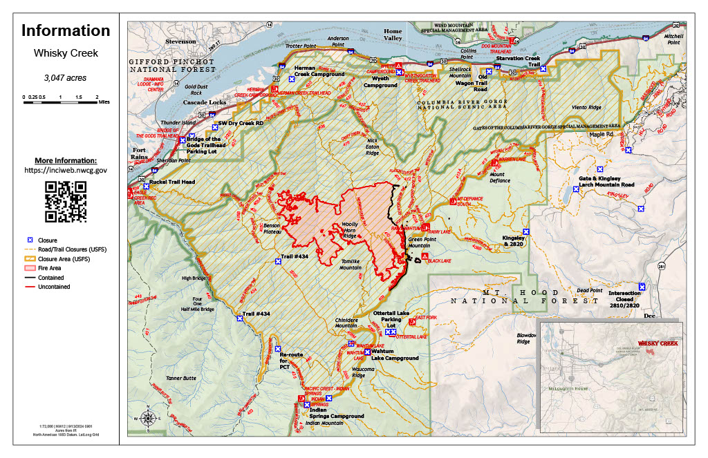
El incendio Whisky Creek se encuentra en un terreno escarpado y escabroso dentro del área de naturaleza Mark O. Hatfield en el Bosque Nacional Mt. Hood. Permanece dentro de las líneas de control a lo largo de los extremos sur y este. La huellas del incendio Eagle Creek continúan como barrera a lo largo de los extremos oeste y norte del incendio.
En las últimas 24 horas hubo una intensidad mínima de fuego mientras los equipos de bomberos trabajaron para reparar los caminos forestales 2820 y 2810. Los bomberos patrullaron las líneas desde el extremo sureste del incendio hasta Green Point Mountain y hacia el norte hasta la huella del incendio Eagle Creek. Las cuadrillas terminaron de reparar las líneas de mano alrededor de los fuegos salpicados por arriba Black Lake. Anoche se realizó un vuelo de infrarrojos (IR) que indicó que el incendio ha crecido por 37 acres en los últimos tres días, y ahora tiene una totalidad de 3,084 acres.
El condado de Hood River anunció que han abierto de nuevo algunas carreteras y senderos para bicicletas, además de haberse abierto el campamento Kingsley Campground. Para obtener más información sobre qué carreteras y áreas se han abierto, consulte el sitio web del condado de Hood River: https://www.hoodrivercounty.gov/forestry
Clima: Esta noche se desplazará del área el actual sistema de alta presión y lo seguirá un sistema de baja presión que permanecerá hasta mañana. Este resultará en otra ronda de temperaturas más frescas, así como la posibilidad de lluvia.
Para saber el pronóstico de humo y seguridad, consulte: oregonsmoke.org.
Cierres: Los cierres de áreas permanecerán en el Bosque Nacional Mt. Hood, el Área Escénica Nacional Columbia River Gorge y el Condado de Hood River. Se establecen cierres para la seguridad del público y de los bomberos; La intrusión en un área de cierre puede interrumpir las actividades de extinción y reparación de incendios, poner en peligro vidas y propiedades, y puede resultar en multas. La información de cierre se encuentra en: https://linktr.ee/whisky_creek.2024.
Seguridad: El público juega un papel importante en la prevención del próximo incendio forestal; tenga cuidado con cualquier posible fuente de incendio. Para obtener consejos de prevención, consulte: https://keeporegongreen.org. La TFR sigue vigente para el incendio Whisky Creek: https://tinyurl.com/2s49yrj4. Las restricciones contra incendios están vigentes dentro del Bosque Nacional Mt. Hood:https://www.fs.usda.gov/main/mthood/fire
Homestead Complex and Lane 1 Fire Daily Update for Saturday September 14 2024 09 14 2024
Related Incident:
Publication Type: News
Email: 2024.homesteadcomplex@firenet.gov
Fire Information Line: 541-208-7100 (Staffed 8 a.m. to 8 p.m.)
Facebook: https://www.facebook.com/HomesteadComplexFireInfo/
Inciweb: Homestead Complex https://t.ly/syeHa and Cottage Grove - Lane 1 https://t.ly/QBrum
September 14, 2024
Northwest Complex Incident Management Team 7 took over management of the Homestead Complex and the Cottage Grove – Lane 1 fires last night. In total, 510 people are assigned to these fires. Fire managers are continuing to use direct and indirect tactics to respond to all the fires under a full suppression strategy. Three of the seven fires in the Homestead Complex are 100% contained: the Salmon 33 Fire (275 acres); the Reynolds Butte Fire (334 acres); and the Lost Bucket Fire (34 acres). Crews are improving containment lines by reducing fuels through mastication, chipping wood, and hauling fuel to landings away from the fire.
On the Horse Heaven Fire (2,715 acres, 56% containment), crews will continue with mop-up operations on lined spots ON the north flank. Road clean-up, chipping and log hauling is underway on other flanks of the fire.
On the Fuller Lake Fire (3,516 acres, 0% containment) yesterday, firefighters on the west flank cut out trees blocking the 3810 Road where the fire had previously crossed. Crews also continued mopping up a spot fire on the southwest corner near the 3810 Road. Today, the plan is to continue mopping up, chipping, road clearing, and locating additional control lines.
The Bullpup Fire (520 acres, 7% containment) remains within control lines. Yesterday, crews were busy with chipping and road clean-up on the 200 Road that is serving as a primary control line. The priority objective for fire managers is to prevent the fire from progressing further north toward critical habitat for wild steelhead (the Frank and Jeanne Moore Wild Steelhead Special Management Area).
On the No Man Fire (2,089 acres, 44% containment), crews will be patrolling, mopping-up, chipping, hauling logs and conducting suppression repair operations.
On the Lane 1 Fire (29,951 acres, 99% containment),clean-up and suppression repair work will continue around the fire. The work includes chipping vegetation and log hauling operations and repairing forest road infrastructure. This work will also make road travel safer for the public once closures to public lands are removed.
Closures and fire restrictions: Two closure orders impact every District of the Umpqua National Forest https://t.ly/Mvn6G. The forest is in High Fire Danger with Public Use Restrictions at Level 2 https://t.ly/LI4cd. A Bureau of Land Management (BLM) Roseburg District closure order for portions of BLM land bordering the Umpqua National Forest closure north of Steamboat remains in effect https://t.ly/uWX6l.
Weather: Cooler weather with higher humidity has helped reduce fire behavior. This trend will continue through next week, with periods of rainfall expected. Some limited periods of drying may create isolated areas of visible smoke.
Whisky Creek Fire update 09 14 2024
Related Incident: Whisky Creek Fire
Publication Type: News
Whisky Creek Size: 3,084 acres | Start Date: July 20 | Cause: Human | Containment: 25%
Total Resources: 121 | Hand Crews: 3 | Engines: 3 | Dozers: 2 | Heavy Equipment: 2 | Helicopters: 1
The Whisky Creek Fire is in steep and rugged terrain within the Mark O. Hatfield Wilderness in the Mt. Hood National Forest. The fire remains within the control lines along the southern and eastern edge. The Eagle Creek Fire scar continues to be a barrier along the western and northern edges of the fire.
The last 24 hours produced minimal fire behavior as fire crews continued working to repair Forest Roads 2820 and 2810. Firefighters patrolled lines from the Southeast portion of the fire all the way to Green Point Mountain and north to the Eagle Creek burn scar. Crews completed full repair on hand lines around the spot fires above Black Lake. An infrared (IR) flight was performed last night to show the fire has increased in size by 37 acres over the last three days for a total of 3,084 acres.
Hood River County has announced they have re-opened some roads and bike trails in addition to opening Kingsley Campground. For more information on which roads and areas have been opened please visit the Hood River County website: https://www.hoodrivercounty.gov/forestry
Weather: The current high-pressure system will be moving out of the area tonight and is being followed by a low-pressure system which will remain well into tomorrow. This will bring another round of cooler temperatures as well as a chance of showers.
For smoke forecasts and safety, visit: oregonsmoke.org.
Closures: Area closures remain in the Mt. Hood National Forest, Columbia River Gorge National Scenic Area, and Hood River County. Closures are put into place for the safety of the public and fire crews; intrusion into a closure area can disrupt fire suppression and repair activities, endanger lives and property, and can result in fines. Closure information is at: https://linktr.ee/whisky_creek.2024.
Safety: The public plays an important role in preventing the next wildfire; please use caution with all potential ignition sources. For prevention tips see: https://keeporegongreen.org. The Temporary Flight Restriction remains in effect for the Whisky Fire: https://tinyurl.com/2s49yrj4. Fire restrictions are in place on the Mt. Hood National Forest: https://www.fs.usda.gov/main/mthood/fire.
Middle Fork Complex Community Meeting September 13 2024 09 14 2024
Related Incident:
Publication Type: Announcement
Bachelor Complex Flat Top and Firestone Fires Update 09 14 2024
Related Incident: Bachelor Complex FiresFlat Top and Firestone Fires
Publication Type: News
Northwest 3 Complex Incident Management Team
Lonnie Click ~ Incident Commander
September 14, 2024
Bachelor Complex and Flat Top and Firestone Fires Update
Quick Facts: Bachelor Complex
Size: 10,801 acres Start Date: Sept 8, 2024 Location: 20 miles SW Bend, OR
Personnel: 436
Quick Facts: Firestone & Flat Top Fires
Firestone Size: 9,117 acres Start Date: Sept 6, 2024 Location: North of Fort Rock, OR
Flat Top Size: 33,172 acres Personnel: 229
Yesterday, firefighters continued to establish containment lines and conduct strategic burning operations on the Bachelor Complex, Flat Top and Firestone Fires. Due to the decrease in temperatures and wind, the fires produced less smoke than in previous days. Unburned pockets of vegetation continue to burn and produce smoke within the interior of the Firestone and Flat Top Fires. Crews also worked night shifts to patrol and secure these areas. These are priority fires in the region and more personnel, heavy equipment and aerial resources continue to arrive to support suppression efforts. Today, firefighters will continue to establish and secure containment lines and conduct tactical burning operations around the Bachelor Complex, Flat Top and Firestone Fires.
Bachelor Complex: The higher elevation fires in the Bachelor Complex near the Cascade crest have experienced minimal fire growth over the last three days due to cooler temperatures, higher moisture levels and good overnight humidity recovery. Crews continue to mop up and secure the eastern flank of the Little Lava Fire east of Forest Service Road (FSR) 45. Firefighters will continue to scout for opportunities to establish and connect control lines to Edison Trail north of the Little Lava Fire perimeter. On the Backside and 911 Fires, crews will continue to strengthen containment lines and extinguish sources of heat within the fire perimeter.
Flat Top Fire: Yesterday, firefighters successfully used tactical firing operations to secure control lines along FSR 410. If conditions are favorable, firefighters plan to continue strategic firing operations today to help secure control lines along the western flank near Willow Butte and northeast corner from FSR 410 towards FSR 470 and FSR 18.
Firestone Fire: Resources continue to reinforce containment lines along the southern and southwestern flanks of the fire near the base of East Butte to FSR 220. Today, crews will also continue to prepare roads south and southeast of the fire in preparation for potential burning operations in the coming days.
Weather and Fire Behavior: Vegetation on the Bachelor Complex fires will continue to dry out a little with temperatures today in the mid-50’s. West, northwest winds could gust up to 20 mph this afternoon. On the Firestone and Flat Top Fires, moisture levels will drop and are expected to reach 25-30% relative humidity this afternoon with warm weather in the mid-70’s. The wind will shift to the northwest this afternoon with gusts up to 18 mph. Saturday night a passing shower is possible late with patchy fog mainly over the Bachelor Complex.
Evacuations: Deschutes County lowered some evacuation levels on the Bachelor Complex yesterday, September 13. Emergency management and fire officials are revaluating evacuation levels daily. Level 3 evacuations mean “Go Now,” Level 2 means “Be Set” and Level 1 means "Be Ready.” To view current evacuation levels, please visit the Deschutes County Emergency Information Interactive Map at: http://www.deschutes.org/emergency. For Lake County evacuation information, please visit: https://www.lakecountyor.org/flat_top.php
Closures: There are two temporary emergency closure areas on the Deschutes National Forest for these fires. View the updated closure orders and maps on the Deschutes National Forest site at: https://www.fs.usda.gov/alerts/deschutes/alerts-notices.
Facebook: facebook.com/deschutesnationalforest/
InciWeb:
inciweb.wildfire.gov/incident-information/ordef-bachelor-complex-fires
inciweb.wildfire.gov/incident-information/ordef-flat-top-and-firestone-fires
YouTube: youtube.com/@CentralOregonFireInfo
Fire Information Line: (541) 249-9829, 8:00 a.m. to 8:00 p.m.
Smoke & Air Quality Information: fire.airnow.gov
Coffee Pot Fire Daily Update 09 14 2024
Related Incident: Coffee Pot Fire
Publication Type: News
Unified Command: CAIIMT15 & CAL FIRE
Fire Size: 14,080 acres
Percent Contained: 71%
Primary Strategic Control Line: 96%
Personnel: 833
Cause: Lightning
Start Date: Saturday, August 3, 2024, at 10:05 a.m.
Location: Southeast of Three Rivers, CA
CURRENT SITUATION: Southeastern Area Complex Incident Management Team Two will shadow California Interagency Complex Incident Management Team 15 today and take command of the Coffee Pot Fire at 7:00 a.m. on Sunday, September 15th. Shadowing ensures a smooth transition from one team to another with the transfer of the current strategic situation that has taken place over the team’s tenure.
On the fireline, crews continued to work diligently on the fire activity south of Homers Nose and around the confluence of Horse Creek and the East Fork Kaweah River. Aircraft reinforced hand line construction with targeted retardant applications and firefighters monitored the line throughout the day to ensure it was holding. Building on progress from the previous day’s work, firefighters continued to mop-up and secure the line around the remainder of the fire’s edge. Fire behavior continued to diminish; control lines are holding well, and most of the remaining smoke and heat are well inside the burned area and are not expected to threaten the control lines.
Today, firefighters will continue to work on the northeast portion of the fire; construction will continue on the direct handlines that run parallel to the East Fork Kaweah River and adjacent to Horse Creek. Crews around the remainder of the fire perimeter will continue to hold and patrol the lines and backhaul any unneeded equipment. Road work, fuel reduction, and contingency line planning will continue on Mineral King Road east toward Silver City. Crews will evaluate structure protection needs around the communities of Mineral King, Silver City, and Cabin Cove o an abundance of caution in the unlikely event that the eastern flank of the fire breaches control lines.
WEATHER: Similar temperatures and winds can be anticipated across the area today. Smoke dispersion will be slightly better due to a moderately less stable atmosphere aloft. As a low-pressure system moves in from the north on Sunday, expect a small drop in daytime temperatures, a slight increase in relative humidity and afternoon winds, and a very slight chance of precipitation on Sunday night.
SMOKE IMPACTS: Expect similar conditions today as yesterday throughout the outlook area. Hammond will continue to see MODERATE air quality conditions, while areas far north and south of the fire will be in GOOD air quality today. Giant Forest and Three Rivers may see brief periods of MODERATE impacts late afternoon. For more information on current wildfire smoke impacts in your community, please visit AirNow.gov or fire.airnow.gov.
EVACUATION NOTICES: The Tulare County Fire Department has issued Evacuation WARNINGS for zones TLC-E094-B, TLC-E094-C, TLC-E094-D, TLC-E094-E, and TLC-E095. To find your zone, please refer to: protect.genasys.com.
FIRE INFORMATION: A Public Information Officer will be at the Three Rivers Village Market daily from 11:00 a.m. to 4 p.m. to provide fire information and answer questions.
BLM AND PARK CLOSURES: The portion of South Fork Drive within Sequoia and Kings Canyon National Parks and trails accessed from the road, including the Ladybug and Garfield Grove Trails, are closed. Recreational access to the Mineral King area of Sequoia National Park is closed to the public. This applies to Mineral King campgrounds, trailheads, and area trails. All other areas of the parks are open but are likely to be impacted by varying levels of smoke and poor air quality. Park closure information is available online at nps.gov/seki. The Bureau of Land Management has also issued a closure of the Case Mountain Extensive Recreation Management Area at blm.gov/press-release.
PUBLIC NOTICE: Wildfires are a no-fly zone for unauthorized aircraft, including drones. If you fly, we can’t. For more information, visit knowbeforeyoufly.org.