
West Mountain Fires Daily Update September 15 2024 09 15 2024
Related Incident: Dollar Fire
Publication Type: Announcement
Snag Fire, 11 miles E of Cascade, 33,300 acres, 27% contained, https://tinyurl.com/4k9dk3mu
Dollar Fire, 18 NE of Cascade, 4,360 acres, 8% contained, https://tinyurl.com/bef6r3tz
Goat Fire, 11 miles SE of Cascade, 26,456 acres, 0% contained, https://tinyurl.com/2h4a3dvr
Cause: Lightning (All Fires)
Personnel: 695
Special Note: Today is the last workday for Army crews from the 14th Brigade Engineer Battalion based at Joint Base Lewis McChord (JBLM). The Sierra Pacific Jets will transport the soldiers back to JBLM in Washington state on Tuesday, September 17. The fire management team is grateful for the opportunity to have partnered with the military in this way.
Weather and Fire Behavior: Today, the temperature highs should be in the mid 60s, with a minimum relative humidity of 29%. Winds are predicted from the SW at 6-10 mph with gusts to 20 mph. Isolated showers and thunderstorms may begin in the evening, going through the night into Monday morning. There should be a break from precipitation during the day, with showers returning Monday night through Tuesday with predictions from 1/2” to 1”. The remaining week should remain cool and humid. Yesterday, clouds moved in, and this moderated fire behavior even more than predicted. Very little activity is predicted again today with mostly smoldering and maybe small amounts of creeping.
Dollar Fire:
- The Dollar Fire remains unstaffed overall, however, suppression repair activities will occur in conjunction with guidance from Resource Advisors. Today, this repair will focus particularly on handline rehabilitation.
- Fire Suppression Repair is a series of immediate post-fire actions taken to repair damages and minimize potential soil erosion and impacts resulting from fire suppression activities.
Snag Fire:
- Firefighters are backhauling equipment from the Warm Lake Rd. area. Helicopters assisted in this equipment removal yesterday by hauling out “sling loads” – nets filled with cargo and suspended from a line. This is utilized when equipment is in hard to access places.
- Crews continue patrolling along the Warm Lake Rd. on the northwest side of the fire.
- To the northeast, firefighters have completed structure assessments in the Warm Lake and Fish Hatchery area and continue with structure preparation efforts.
- To the southeast, firefighters will assess Rice Peak Lookout to determine if it needs structure protection efforts.
- On the west side, structure assessments and protection efforts continue in the Horsethief area.
- Today, crews will begin constructing a dozer line from the west edge of the Snag Fire toward the Horsethief Reservoir and are scouting for another dozer line further south on Horsethief Rd heading northeast back toward the fire’s edge. Masticators will work in conjunction with dozers to clear fuel from these lines.
- Near the southern tip of the Snag Fire, off the 409 Rd, crews are mopping up from the pile burning performed a few days ago to remove fuel from this area.
Goat Fire:
- Crews are working to connect the gap between the northern-most point of the Goat Fire and the southern-most tip of the Snag Fire with a combination of dozer and handline.
- Near the northwest edge of the fire, there are multiple small UTV roads and trails winding through the area. Crews are working to improve and piece these roads and trails together, constructing a combination of indirect and direct line along this northeastern edge.
- On the west side of the Goat Fire, firefighters continue scouting for options to build line that will connect the 099 Trail to the 417 Road and then to the 409 Road.
- Firefighters are widening the 409 road to make this a larger fuel break to help with the above objective.
Wapiti Fire Update Sunday Sept 15 2024 09 15 2024
Related Incident:
Publication Type: News
Wapiti Fire Statistics
Size: 125,459 acres
Completion: 29%
Total Personnel: 849
Location: Grandjean, ID
Reported: July 24, 2024
Cause: Lightning
For More Information
Information Phone: 208-593-7132
Email: 2024.wapiti@firenet.gov
InciWeb: https://inciweb.wildfire.gov/incident-information/idbof-wapiti-fire
Facebook: https://www.facebook.com/wapitifireinfo2024
Linktree: https://linktr.ee/WapitiFireInfo2024
Interactive Map: https://tinyurl.com/WapitiFireInfoMap
Special Notes: The rain events of the last week contributed to slowing of fire activity, a drastic decrease in smoke, and improvement of air quality for all communities in and around the Wapiti Fire. Hazards associated with the fire's suppression still requires the closure of Highway 21 throughout the weekend.
With over 313 miles of fire perimeter, it is not feasible for firefighters to manually check every piece of the perimeter for hot spots. As such, the fire suppression strategy for the Wapiti Fire transitioned to a mix of confinement and containment tactics. Containment utilizes a combination of direct and indirect fire lines that resources build. Confinement uses a combination of natural geographic features that are expected to hold any growth of the fire. These features can include rock bands, ridges, burn scars, or other fuel type changes. Both of these strategies are represented through a percentage and combined, will be reflected through percent “completed.” Containment tactics have been used to secure the eastern edge of the fire and have allowed the communities in and around Stanley to return to their homes, as well as protecting values around the Cape Horn area. Firefighters have simultaneously engaged in direct and indirect containment tactics with the goal of protecting values at risk in the Lowman area, including various residences and recreational infrastructure. The weather events of the past week and the anticipated weather arriving again on Monday will allow fire managers to more fully assess portions of the western and southern areas of the fire that are using a confinement strategy.
The last full night operational period was completed Saturday night. A partial operational period will occur Sunday evening. Aggressive efforts in division MM and PP, in conjunction with the forecasted precipitation this week, has eliminated the need for night operations.
Current Situation: The Grandjean area is secure, and all the structure protection equipment was removed. Today (09/15) homeowners will be escorted into Grandjean to winterize their homes.
Communities of Ten Ax, Two Ravens, Seven Peaks, and others South of Highway 21 have full structure protection mitigations in place with hoses, sprinklers, and fold-a-tank systems at the ready. Pump systems have been winterized and are staged in the area, ready for quick deployment if necessary. Careful planning and attention have been taken to ensure heavy equipment does not damage those communities.
The north side of Highway 21, Sourdough and all parts of Lowman have similar structure protection measures in place; hoses, sprinklers, fold-a-tanks, and winterized pump systems to facilitate the containment strategies that are needed in those areas.
Incoming rain is expected Monday into Tuesday, which will further assist with minimizing fire behavior and enhancing confinement strategies.
Division KK (Structure Group East), HH, and DD: Suppression repair efforts are underway with the end goal of repairing disturbance caused by the initial suppression and structure protection efforts. Miles of hoses, pumps, and other equipment have been removed (backhauled) from the area.
Divisions MM and PP: No further firing operations are planned in the Cape Horn area as conditions are not favorable for burnout operations. Based on visible growth and infrared data fire managers are comfortable with the containment achieved in this area. Some suppression repair activities are underway with the assistance of heavy equipment.
Division WW and Structure Group West: Fire activity in the 8-mile area picked up as clouds cleared and the vegetation was exposed to direct sunlight and wind. Heavy helicopters continued to keep the line checked on the ridge with strategically placed bucket drops. No additional growth was observed. Structure protection remains in place if the fire does move down the 8-mile drainage. Firefighters had to disconnect and winterize some of the pumps to ensure they don’t freeze with the cold nighttime temperatures.
Division VV: Infrared flights show isolated and scattered heat along the southern perimeter of the fire located in the wilderness area. Natural barriers, such as rocky scree and cliffs continue to hold the perimeter in place.
Weather, Fuels, and Fire Behavior: Fall weather trends are continuing with cool mornings and temperatures increasing to low 70s throughout the day. Dry conditions are expected Sunday as the high-pressure front continues across the region. Incident Meteorologists anticipate colder weather and precipitation starting late Monday evening and continuing over the next several days. Fire managers expect a stronger storm than the previous week, which will bring more moisture.
Evacuations:
For evacuation information on the Wapiti Fire, please see the Custer County Sheriff’s Facebook page at https://www.facebook.com/p/Custer-County-Sheriff-Idaho-61558947312289/ and the Boise County Sheriff’s Facebook page at https://www.facebook.com/boisecountysheriff/.
To sign up for Custer County CodeRED emergency notifications, text CUSTER to 99411 or enroll online at https://public.coderedweb.com/CNE/BF28E45537FF
To sign up for Boise County Alert Sense emergency notification enroll online at https://public.alertsense.com/SignUp/publicUser.aspx?regionid=1163
Closures and Fire Restrictions:
The Middle Fork Complex Fire Closure Order is amended to provide consistency with the Wapiti Fire closure. This amended order, Forest Order #0402-06-64, closes the 582 and 563 roads, as well as the 579 road from its junction with 563 eastward to the junction with Highway 21. More information can be found at: https://www.fs.usda.gov/alerts/boise/alerts-notices
State Highway 21 remains closed from MP84 (Sourdough Lodge) to MP126 (Stanley Lake turn off) for public and firefighter safety.
A Wapiti Fire Area Closure / Forest Order: 0414-04-151 for portions of the Boise, Sawtooth, and Salmon-Challis National Forests can be found at this site: https://www.fs.usda.gov/alerts/sawtooth/alerts-notices
Boise National Forest Stage 1 Fire Restrictions / Forest Order: 0402-00-63 can be found at this site: https://www.fs.usda.gov/alerts/boise/alerts-notices
Sawtooth National Forest Stage 1 Fire Restrictions / Forest Order 0414-00-044 can be found at this site: https://www.fs.usda.gov/alerts/sawtooth/alerts-notices
Fire restrictions on federal, state, and private lands may be found at this site: https://www.idl.idaho.gov/fire-management/fire-restrictions-finder/
A Temporary Flight Restriction (TFR) is in place over the Wapiti Fire. Wildfires are a no-fly zone for unauthorized aircraft, including drones. If you fly, we can’t. For more information, visit http://knowbeforeyoufly.org.
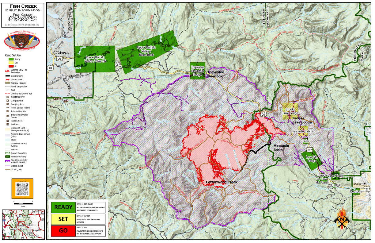
Fish Creek Fire Update Sunday 09 15 2024
Related Incident:
Publication Type: News
Northern Rockies Team 2, Incident Commander Scott Schuster
Location: 7 miles SW of Togwotee Pass
Start Date: Friday, August 16, 2024
Cause: Lightning
Size: 25,009 acres
Percent complete: 69%
Resources: 415 Total Personnel: 9 Hand Crews; 10 Engines; 17 Heavy Equipment; 1 Type 3 Helicopter
KEY MESSAGES:
The Bridger-Teton and Shoshone National Forests have updated the Closure Order for the area of the fire. Additional information regarding the current closure order can be found in the Forest websites.
Creeping, smoldering, and backing behavior of the Fish Creek Fire will continue with a minimal potential for single tree torching.
Watch for heavy equipment traveling in the Highway 26/287 corridor that could significantly slow travel. Please slow down and use caution when driving in this area.
CURRENT STATUS:
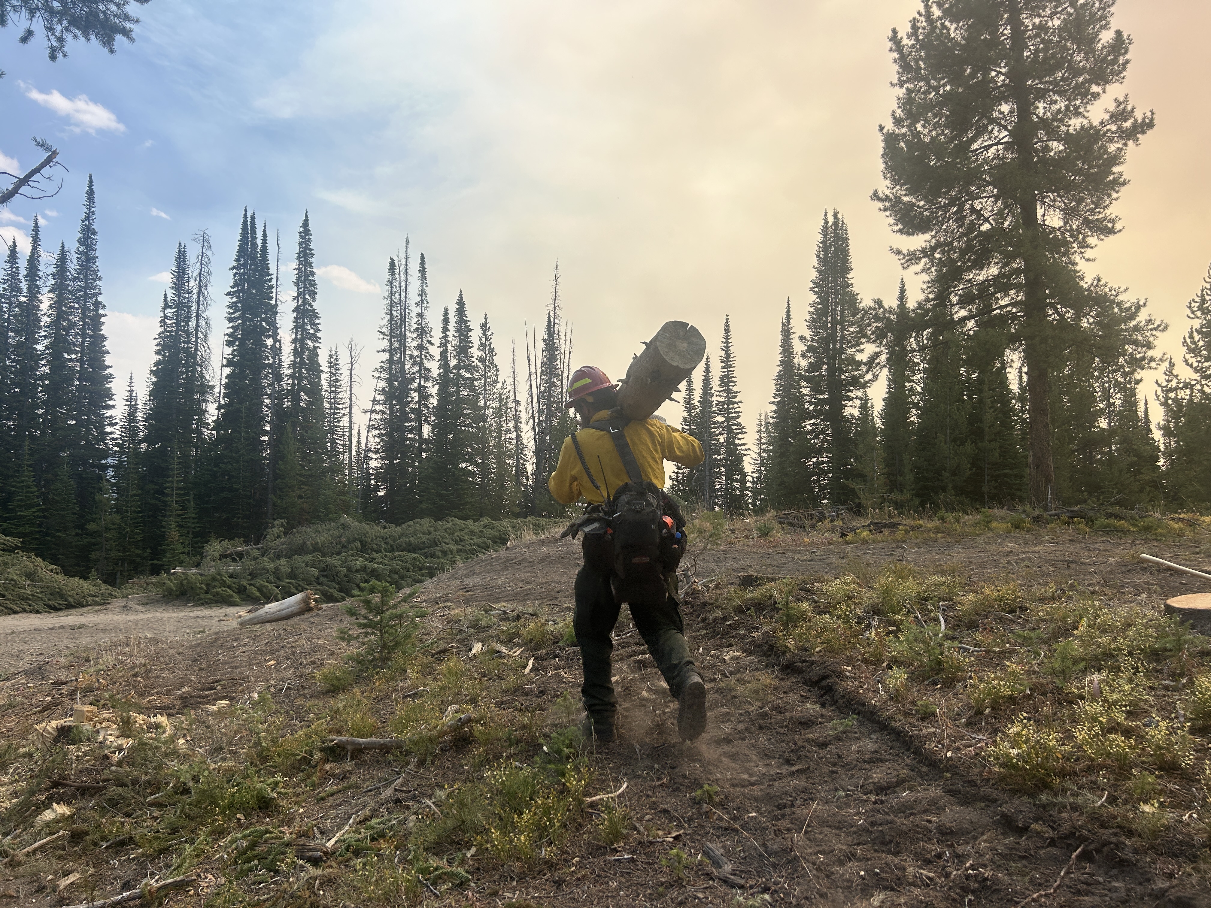
Crews started the suppression repair on Continental Divide Trail while another group of firefighters removed all the hoses and related equipment that are no longer necessary in that area.
Yesterday, firefighters finished the work of repairing some impacts and minimize potential soil erosion resulting from the fire suppression activities along Deception Road from Highway 26 to Brooks Lake Lodge campground. Weather conditions allowed overnight flights through the fire area for reconnaissance to update the fire acres and spread. This data is utilized to make operational decisions for the fire. Firefighters are continuing fuels mitigation actions take place around the Togwotee Lodge. This action will reduce the ability of the fuels to feed the fire and will improve defensible space for values at risk (including the Highway 26 corridor, Brooks Lake, Pinnacle and Breccia Drive) from the Fish Creek Fire, or future wildfires.
Numerous hazards remain in the fire, for example, dead trees where roots could have been weakened by fire along with steep slopes that no longer have small vegetation holding soil in place.
WEATHER AND FIRE BEHAVIOR:
Across the fire zone, mostly sunny skies and warmer temperatures are expected today with isolated showers in the afternoon. Today will be dryer than the last two days, with a high-pressure system and mostly cloudy. A slight chance for showers and thunderstorms returns to western Wyoming on Monday. The observed fire behavior is expected to be creeping and smoldering, with isolated tree torching in the interior of the fire.
AIR QUALITY AND SMOKE:
Although air quality has improved, unhealthy air quality is possible in some locations. For up-to-date air quality alerts, current and predicted smoke conditions and ways to mitigate poor air quality, check out the AirNow website at https://www.airnow.gov/.
CLOSURES AND EVACUATIONS:
The joint Closure Order issued by both the Bridger-Teton and Shoshone National Forests for the fire area, remains in effect. Please do not enter the closure area or use any Forest Roads that are closed. For specific details regarding this closure, please reference the map at Fish Creek Area, Roads, and Trails Closure Order (map) and the Forest closure order fseprd1204904.pdf (usda.gov).
Under the jurisdiction of Fremont County, the areas of Brooks Lake, Pinnacle Drive and Breccia Drive remain at Level 2 “Set” Status (indicated by yellow blocks on the PIO Incident Map). A Level 2 “Set” Status means residents should be ready to evacuate at a moment’s notice. If the Level 2 Set notice changes back to a Level 3 “Go” notice, residents must evacuate until advised otherwise by Fremont County. See the alert notice on the Fremont County Fire Protection District Facebook page.
The Teton County Division of Emergency Management utilizes a Ready, Set, Go system for evacuation messaging, visit their website for additional details at www.tetoncountywy.gov/1846/Ready-Set-GO. (Indicated by green blocks on the PIO Incident Map.) They advise all residents to be in a “Ready” status by preparing for evacuations and becoming fire adapted. All residents are encouraged to sign up for Teton County, Wyoming's free alert and warning service, Teton WY Alerts at: Teton_WY Alerts - Sign Up (everbridge.net).
US HWY 26/287 is open for free-flowing traffic. Motorists may still experience smoke and sometimes limited visibility. A 45-mph speed restriction remains in effect for the fire area. Motorists are encouraged to stay alert for fire personnel and fire vehicles and use caution when travelling through the area. The Wyoming Department of Transportation (WYDOT) continues to work closely with Fremont County Emergency Management, Fremont County Sheriff’s Office and fire officials for the safety of motorists and firefighters. Drivers are encouraged to visit https://www.wyoroad.info/ prior to traveling on US HWY 26/287 for road status and information, or download the Wyoming 511 app at https://www.wyoroad.info/511/WY511Mobile.html to monitor for any changes due to fire activity.
Daily Update for the Chimney Fire 09 15 2024
Related Incident: Chimney Fire
Publication Type: News
Suppression repair efforts progress on the Chimney Fire
Daily Update – Sunday, September 15, 2024
Acres: 6,519
Start Date: 9/2/2024
Location: 9 miles northwest of Fairfield, ID
Personnel: 300
Containment: 21%
Fuels: Timber, brush, grass, understory
Highlights: Firefighters are working in coordination with local Resource Advisors to increase suppression repairs efforts across the fire area. Warmer, drier weather resulted in slightly increased fire activity yesterday, although no additional fire spread was recorded. Crews are carefully monitoring for any hotspots or potential fire spread using both ground patrols and aerial reconnaissance.
Operations: Firefighters continued to identify new suppression repair projects yesterday. Berms that were created during dozerline construction were flattened, and water bars were installed to prevent future erosion and runoff. Scattering of brush and cut vegetation from chainsaw activities was completed to help return the area to a more natural condition. Resource Advisors are aiding firefighters in these activities by ensuring that sensitive resources are not negatively impacted and burned areas are restored appropriately. Crews also initiated repairs around cabins and other infrastructure near the southern portion of the fire. Firefighters observed slightly increased smoldering and creeping in heavy dead and down timber as a drying pattern settled into the region. On the west side, crews are closely monitoring along the Middle Fork of Lime Creek searching for any evidence of increased fire activity. Suppression repair efforts will continue across the fire as crews attempt to make progress ahead of incoming storms.
Weather: Sunday will be the last day of the next seven days where temperatures will warm above 70 degrees, at 65 to 75 degrees for high temperature across the area. Humidity recovery will be poor at 38 to 50 percent, with afternoon humidity readings of 16 to 24 percent. Southern winds will continue with afternoon gusts in the 20 to 28 mph range. An incoming storm will bring rain Sunday night and potentially moderate to heavy rain on Monday night and Tuesday.
Smoke: Smoke may be visible from the Fairfield area, with possible haze in the afternoon today. An interactive smoke map located at https://fire.airnow.gov/ allows you to zoom into your area to see the latest conditions.
Closures: The Sawtooth National Forest has issued an emergency temporary closure area for the Chimney Fire. The purpose of the closure order is to protect firefighters and the public during wildfire suppression activities occurring in and around the area. The full closure order (No. 0414-05-065) and map are available on the Sawtooth National Forest website at https://www.fs.usda.gov/alerts/sawtooth/alerts-notices.
Safety: The health and safety of firefighters and the public are always the first priority. A temporary flight restriction (TFR) is in place over the area, which includes uncrewed aircraft or drones. Flying drones near wildfires is dangerous for pilots and firefighters and can bring wildfire suppression efforts to a halt. Know before you fly. If you fly, we can’t. More information can be found at: https://uas.nifc.gov/.
More Information: https://inciweb.wildfire.gov/incident-information/ideix-chimney-fire / 208-246-8292 / https://www.facebook.com/sawtoothnationalforest / 2024.chimney@firenet.gov / https://www.facebook.com/IdahoDepartmentofLands/
Airport Fire Incident Update Evening 09 14 2024
Related Incident:
Publication Type: News
Location: Trabuco Canyon, CA
Personnel: 1949
Start Date: 9/9/ 2024 01:00pm
Cause: Human
Size: 23,519 acres
Percent contained: 19%
The Airport Fire is 23,519 acres with 19% containment. Active fire behavior was observed near Modjeska Peak and Sugar Loaf today. Multiple aircraft were utilized to address the increased activity and assist ground crews in moderating fire behavior. Substantial progress was made toward Bell Canyon through the combined efforts of heavy equipment, hand tools, and aerial support. In Trabuco Canyon, direct and indirect firelines were successfully constructed toward El Cariso. Ongoing efforts focused on preventing further property loss and establishing a containment line to confine the fire within its current boundaries. Damage assessment teams diligently evaluated the extent of structural damage, and those efforts will continue as they gain access.
Favorable weather conditions persisted, with the marine layer returning this evening and forecast light precipitation in the coming days. Despite recent weather, the dry vegetation has exhibited active fire behavior, indicating the continued risk of increased fire activity.
Evacuation levels are being assessed daily by fire managers in collaboration with law enforcement based on fire containment and safety considerations. Efforts are underway to safely return residents to their homes as conditions permit.
Fossil Complex Evening Update 09 14 2024
Related Incident: Fossil Complex
Publication Type: News
Drier Conditions Today On The Service Fire
SPRAY, Ore. – Containment lines were completed across all divisions on the Service Fire. The fire continued to pose problems on the eastern side of the fire as heat hidden under juniper trees flared up today, slowing the installation of plumbing and mop up. The unburned island in the middle of the fire, consisting of 600 acres of grass and timber, was lined today and mop up will begin tomorrow.
With the installation of some additional hose lays tonight, mop up will be occurring across all divisions. Aircraft will be dropping water to cool flare ups and areas of heat to support the efforts of the crews on the ground. The plan for tonight is to continue cooling hot spots, secure line and install hose lays where needed to set the day shift up for success.
Fire behavior and weather conditions created the potential for fire to spread, testing the lines in some areas. Fire Behavior Analyst Boone Zimmerlee reported that the fire activity he observed was within the ability of nearby crews to catch.
Temperatures were in the upper 60s to lower 70s today with wind of 3-5 MPH out of the west-northwest with gusts of 10-15 MPH. Decreasing clouds are expected tonight, with relative humidity recovering to 60-80%. A low-pressure system will affect the area tomorrow with possible morning sprinkles and a potential for additional light rain tomorrow night. Firefighters are expecting cooler temperatures with winds similar to today.
Videos: Recordings of the Daily Operations Updates and other stories are available at: https://www.youtube.com/@FossilComplex.
Evacuation: Level 3 evacuations remain inside the perimeter of the Service Fire. For the most recent evacuation levels please go to: https://www.facebook.com/WheelerCountySheriffsOffice/
The Two Cabin, Holmes, Kinzua and Canyon Fires are all in patrol status.
FIRE AT A GLANCE
Fossil Complex
Total Size: 24,431acres
Two Cabin-253 acres
Canyon-192 acres
Kinzua-96 acres
Holmes-15 acres
Service- 23,875
Containment: 8%
Cause: Lightning
Current Cost: $16.2 M
All Resources
Hand Crews: 41
Engines: 59
Water Tender: 12
Dozers: 21
Skidders: 7
Skidgen: 4
Excavator: 2
Masticator: 3
Feller Buncher: 4
Total Resources: 1,294
Aerial Resources
Type 1: 5
Type 2: 8
Type 3: 4
UAS 3: 1
Evacuations:
Level 3: 11 addresses
https://www.facebook.com/WheelerCountySheriffsOffice/
ODF Incident Commander:
Matt Howard
Incident Management Team 2
Shoe Fly Fire Morning Update 09 14 2024
Related Incident: Shoe Fly Fire
Publication Type: News
Firefighters push toward completion of mop up
MITCHELL, Ore. – Mop up on the Shoe Fly Fire is near completion. Firefighters have reached 300 feet of cold black adjacent to the perimeter on much of the 26,774 acre fire, resulting in an increase of containment to 77%.
Today, firefighters will continue to mop up heavier fuels in the Gird’s Creek area on the southwest flank and around Baldy Mountain on the northeast corner of the fire. These areas have timber and larger fuels that hold heat longer and require more water and effort to extinguish. A drone with infrared capabilities will be used in the northeast corner of the fire to locate hot spots, speeding up the mop up process.
Bridge Fire Evening Update 09 14 2024
Related Incident: Bridge Fire
Publication Type: News
Unified Command: CIIMT5, Los Angeles County Fire, Los Angeles County Sheriff, San Bernardino County Fire, San Bernardino County Sheriff, CAL FIRE – San Bernardino/Inyo/Mono Unit
Start Date: September 8, 2024, at 2:12 p.m.
Fire Information: (626) 470-0120 ***Original number***
Media Line: (626) 470-1395
Hours: 7:00 a.m. to 9:00 p.m.
Email: 2024.Bridge@firenet.gov
Fire Size: 53,779 acres
Percent Contained: 5%
Personnel: 2,625
Injuries: 2
Cause: Under investigation
Location: Sheep Mountain Wilderness, San Gabriel Mountains National Monument
CURRENT SITUATION: Today firefighters continued establishing and strengthening direct containment lines while also constructing secondary contingency lines with dozers and hand crews. Several helicopters working the hottest areas helped firefighters make progress, and additionally responded late this afternoon in an assist for containing a new fire start in the Lytle Creek area.
The northwest corner of the fire was most active today. Air operations plans to install a mobile retardant base tonight in that area to aid firefighters in directly attacking it aggressively with night-flying helicopters. Although interior “islands” of unburned vegetation remain in the northern part of the fire, firefighters also plan to go direct and continue holding and securing their containment lines to protect the community of Wrightwood, Pinon Hills and beyond. To the northeast, the fire has reached drainages on the west side of the north fork of Lytle Creek, however firefighters are prioritizing dozer lines and direct attack wherever possible to stop the fire’s spread.
The east side of the fire is less active, however still presenting risks to residents in the Mt. Baldy area so evacuation orders remain in effect. Structure defense groups remain in place throughout the day and night to mitigate any isolated heat and continue the progress made by the previous operating shift.
On the south side, firefighters are still holding their containment line at Sunset Peak area while they continue contingency line construction below it. This area of the fire is where they were able to increase containment percentage by 2 percent.
In the rugged and steep terrain of the Sheep Mountain Wilderness below Mount Baden-Powell, firefighters gained entry in three main locations to construct dozer line and hand lines while aircraft assisted them with extinguishing hotspots.
This afternoon, damage inspection teams released interactive maps for local residents affected by the Bridge Fire. For San Bernardino County visit: https://prepare.sbcounty.gov/bridge-fire/. For Los Angeles County visit: https://recovery.lacounty.gov/bridgefire/.
The next public meeting is scheduled for Monday, September 16 at Lytle Creek Community Center, 14082 Center Rd., San Bernardino, CA at 7:00 p.m. It will also be live streamed via the new Angeles NF Fire Info YouTube page.
Evacuation Orders:
- Mt. Baldy Road, North Mountain Avenue and Shinn Roads from San Antonio Heights to Wrightwood and east to Cucamonga Peak
- Hwy 138 south to Lone Pine Canyon and Highway 2 east to Lone Pine Canyon Road.
- The community of Wrightwood.
- Lone Pine Canyon Road south to the forest.
- East Fork communities of Camp Williams Resort (café, mobile home park, campground) and River Community (near the resort).
Evacuation Warnings:
- West Cajon area of Highway 138 south to Lytle Creek and Oil Well Road East to Stone Basin
- San Antonio Heights and Upland from the foothills south to 23rd Street.
- Piñon Hills from Wrightwood north to Highway 138 and Lebec Road west to Los Angeles County.
- For evacuation warnings in San Dimas, La Verne, and Claremont please visit: Genasys Protect
“Know Your Zone” by visiting the Genasys Protect website or download the app. Protect.genasys.com
If not already registered for emergency alerts, please register here:
- Los Angeles County: https://ready.lacounty.gov/emergency-notifications/
- San Bernardino County: https://wp.sbcounty.gov/sheriff/alerts/
Evacuation Centers:
- San Bernardino County Fairgrounds: 14800 Seventh Street, Victorville, CA
- Jessie Turner Health/Fitness Center: 15556 Summit Ave, Fontana, CA. (909) 854-5100
- Pomona Fairplex: 601 W McKinley Avenue Pomona, CA (Gate 3, corner of McKinley/White)
- Antelope Valley Fairgrounds: 2551 W Avenue H, Lancaster, CA
Animals:
- Devore Animal Shelter: 19777 Shelter Way, San Bernardino, CA. (909) 386-9820. After hours: (800) 472-5609
- Palmdale Animal Care Center (Small Animals): 38550 Sierra Hwy, Palmdale, CA
- Lancaster Animal Care Center (Small Animals): 5210 W Ave I, Lancaster, CA
- Antelope Valley Fairgrounds (Large Animals): 2551 W Avenue H, Lancaster, CA. Call (562) 706-8581
For more information on shelters, visit:
- www.redcross.org/get-help/disaster-relief-and-recovery-services/find-an-open-shelter.html
- https://lacounty.gov/emergency/
CLOSURES:
- SR-138 from Lone Pine Canyon Road to Beekley Road
- SR-2 closed from Big Pines to SR-138
- Big Pines Highway
- Big Rock Creek Road
- San Gabriel Canyon and East Fork of the San Gabriel River
- Highway 39
- East Fork Road
- Glendora Ridge Road and Glendora Mountain Road
- Mt. Baldy Road at Shinn Road intersection
WEATHER:
High humidities are expected tonight, with stronger southwest winds at the heel of the fire. Northwest winds will push down on the fire from the north side. Sunday will see cooler temperatures as well with a significant cold front dropping approximately 1/10 inch of rain and snow above 9,000 feet. Winds will switch from the southwest to the northeast on Sunday, testing containment lines on this fire. Favorable winds, temperatures, and humidity will continue until Thursday, however dry and hot conditions will start again this Friday.
For smoke impacts and an interactive map, visit fire.airnow.gov.
FIRE RESTRICTIONS IN OPEN AREAS OF ANGELES NATIONAL FOREST:
The Fire Danger on the Angeles National Forest is now “Extreme” Angeles National Forest - News & Events (usda.gov)
Additional Information Resources:
Updated Fish Creek Fire Area Road and Trail Closure Order 040324312 09 13 2024
Related Incident:
Publication Type: Closures
U.S. Department of Agriculture, U.S. Forest Service Bridger-Teton National Forest
Jackson & Blackrock Ranger Districts Shoshone National Forest
Wind River District
Fish Creek Fire Area, Road, and Trail Closure
The Fish Creek Fire is burning 7-miles southwest of Togwotee Pass. https://inciweb.wildfire.gov/incident-information/wybtf-fish-creek-fire. The described area, road, and trail closure order is in effect:
Bridger-Teton National Forest Fish Creek Fire Closure area boundary begins where it meets the SW corner of Shoshone National Forest Fish Creek Fire area boundary that abuts the Continental Divide and Bridger-Teton National Forest boundary, at the boundary of Sections 22 and 27, T43N R110W. Continuing W along the section line for approximately 3 miles until the intersection of the FS RD 30750 and then southwesterly along said road (North Fork of Fish Creek) to its intersection with FS RD 30800 then northerly along said road (Cottonwood Creek) to a point approximately ½ mile due east of the confluence of Elkhorn Creek and Cottonwood Creek, due west along this bearing to the confluence of Elkhorn Creek and Cottonwood Creek, then northwesterly along Elkhorn Creek to the hydrologic divide, then southwesterly then north and northwesterly to Mt. Leidy, then northeasterly along the hydrologic divide to its intersection with the South Fork Spread Creek Road (30100) , then northerly along the same road to its intersection with Hatchet Road (30160), then following and including Flagstaff Road (30100) east to its intersection with US Highway 26/287. North across highway 26/287 to the hydrologic divide on Angle Mountain. East along the hydrologic divide to its intersection with the Continental Divide in the center of Section 22 T44N R110W.
The Shoshone National Forest Fish Creek Fire Closure area boundary begins at the SE corner of the Bridger-Teton National Forest Fire closure area. Continuing E along the N side of the section line dividing T43N R110W Sections 27 and 22 to Forest Service Road (FS RD) 540. The closure area continues NW on the W side of FS RD 540 to the intersection with FS RD 540.1D. Continuing NW along the W side of FS RD 540.1D to the intersection with FS RD 540.1E, the closure continues NW on the W side of FS RD 540.1E to the W side of Pelham Lake Creek. Extending E on the NW side of Pelham Lake Creek to the confluence of the Wind River, the closure crosses the Wind River to the private property boundary. At the private property boundary, the closure continues N then E on the W side of the property boundary to Highway (HWY) 26/287 and resumes on the NE side of HWY 26/287. In a SE direction, the closure extends to FS RD 513. The closure continues E on the N side of FS RD 513 to the W side of the section line dividing T43N R109W sections 27 and 26. Continuing N along said section line, the closure extends to the Dunoir Special Management Area (SMA) boundary and continues NW along said boundary to the Continental Divide. The closure continues W and SW along the S side of the Continental Divide until it meets the Blackrock RD boundary. The closure connects with the NE corner of the Bridger-Teton National Forest Fire closure area.
The Described Roads and Trails include the following NFS roads and trails located within and bordering the Described Area:
1. Portion of NFS Road 30750 (Moccasin Basin Road), to its intersection with NFS Rd 30800.
2. Forest Road 30100 (Flagstaff/South Fork Spread Creek Road) in its entirety.
3. Forest Road 30200 (Mary’s Lake) in its entirety.
4. Forest Road 30234 (Nation Creek) in its entirety.
5. Forest Road 30250 (Leidy Lake) in its entirety.
6. Forest Road 30800 in its entirety.
7. NFS Trail 30240 in its entirety.
8. FS RD 30120 (North Fork Spread Creek) in its entirety.
9. FS RD 30140 (Grizzly Creek) in its entirety.
10. FS RD 30010 (Two Ocean Basin) in its entirety.
11. NFS Trail 4079 (Cottonwood Creek Trail), in its entirety.
12. NFS Trail 4106 (Spruce Creek Trail), in its entirety.
13. NFS Trail 6107 (Two Ocean Basin Trail) in its entirety.
14. NFS Trail 6071 (South Fork Spread Creek) in its entirety.
15. NFS Trail 6057 (portion of Holmes Cave Trail south of the hydrologic divide of Angle Mountain.
Shoshone National Forest:
3. Falls Campground Road
4. FS RD 515 in its entirety
5. FS RD 521 in its entirety
6. FS RD 522 in its entirety
7. FS RD 537 in its entirety
8. That portion of FS RD 540 north of its junction with FS RD 540.1D
9. FS RD 540.1A in its entirety
10. That portion of FS RD 540.1E northwest of Pelham Lake Creek
11. FS RD 645 in its entirety
12. MT10 in its entirety
13. North of FS RD 513
14. FS RD 549 in its entirety
15. FS RD 548 and all roads that originate from said road
16. FS RD 548.1D in its entirety
17. FS RD 649 in its entirety
18. FS RD 585 in its entirety
19. FS RD 589 in its entirety
20. FS RD 590 in its entirety
21. FS RD 591 in its entirety
22. FS Trail 807.1A Pinnacles Trail
23. FS Trail 823.1B Bonneville Pass Trail
24. FS Trail 823 Bear Cub Pass Trail
25. FS Trail 823.1A Jade Lakes Trail
26. FS Trails 823.1C Rainbow Lake Trail
27. FS Trail 823.1E Sublette Pass Trail
Rescinded Rogue RiverSiskiyou Closure for Middle Fork Fire 09 14 2024
Related Incident: Middle Fork Fire
Publication Type: Closures
Per the Rogue River-Siskiyou National Forest's Facebook Page:
News Release: Middle Fork Fire Emergency Area & Road Closure Rescinded
Prospect Ore – September 13, 2024 — Rogue River-Siskiyou National Forest Supervisor Molly Juillerat is rescinding the Middle Fork Fire Emergency Area & Road Closure effective at 6:00 a.m. on Saturday, September 14, 2024, in cooperation with the Incident Management Team managing the Diamond Complex on the Umpqua National Forest. The closure is being rescinded as a result of significant progress made with fire operations. The public is reminded to use caution whenever traveling through recently burned areas, particularly on windy days when trees are more likely to fall. The closure was in effect until January 15, 2025 unless rescinded.