
Actualizacin diaria del incendio Whisky Creek 09 15 2024
Related Incident: Whisky Creek Fire
Publication Type: News
Whisky Creek Size: 3,092 acres | Fecha de inicio: 20 de julio |Causa: De orígen humano |Contención 25%
Total de recursos: 113 | Equipos de obreros: 3 | Camiones de bomberos: 3 | Topadoras: 2 | Maquinarias pesadas: 2 | Helicópteros: 1
El incendio Whisky Creek se encuentra en un terreno escarpado y escabroso dentro del área de naturaleza Mark O. Hatfield en el Bosque Nacional Mt. Hood. Permanece dentro de las líneas de control a lo largo de los extremos sur y este. La huellas del incendio Eagle Creek continúan como barrera a lo largo de los extremos oeste y norte del incendio.
En las últimas 24 horas hubo una intensidad mínima de fuego, ya que las excavadoras terminaron de hacer reparaciones en el camino forestal 2820 y ahora se enfocan en el camino forestal 2810. Las cuadrillas de mano pudieron remover maleza alrededor de varias torres de comunicación cerca del Mt. Defiance.
Aunque el condado de Hood River abrió algunos senderos para bicicletas, carreteras y campamentos, los cierres siguen vigentes por la seguridad pública y de los bomberos. Para obtener actualizaciones continuas sobre los cierres del condado, consulte: https://www.hoodrivercounty.gov/forestry.
Clima: Ayer, las temperaturas estuvieron más frescas; Sin embargo, el sistema de baja presión no resultó en la lluvia que se esperaba. Esperaremos a que las temperaturas sigan más frescas con la posibilidad de algunas lluvias aisladas todo el domingo. Existe la posibilidad de que la humedad se dure hasta principios de esta semana.
Para saber el pronóstico de humo y seguridad, consulte: oregonsmoke.org.
Cierres: Los cierres de áreas permanecerán en el Bosque Nacional Mt. Hood, el Área Escénica Nacional Columbia River Gorge y el Condado de Hood River. Se establecen cierres para la seguridad del público y de los bomberos; La intrusión en un área de cierre puede interrumpir las actividades de extinción y reparación de incendios, poner en peligro vidas y propiedades, y puede resultar en multas. La información de cierre se encuentra en: https://linktr.ee/whisky_creek.2024.
Seguridad: El público juega un papel importante en la prevención del próximo incendio forestal; tenga cuidado con cualquier posible fuente de incendio. Para obtener consejos de prevención, consulte: https://keeporegongreen.org. La TFR sigue vigente para el incendio Whisky Creek: https://tinyurl.com/2s49yrj4. Las restricciones contra incendios están vigentes dentro del Bosque Nacional Mt. Hood:https://www.fs.usda.gov/main/mthood/fire
Whisky Creek Fire update 09 15 2024
Related Incident: Whisky Creek Fire
Publication Type: News
Whisky Creek Size: 3,092 acres | Start Date: July 20 | Cause: Human | Containment: 25%
Total Resources: 113 | Hand Crews: 3 | Engines: 3 | Dozers: 2 | Heavy Equipment: 2 | Helicopters: 1
The Whisky Creek Fire is in steep and rugged terrain within the Mark O. Hatfield Wilderness in the Mt. Hood National Forest. The fire remains within the control lines along the southern and eastern edge. The Eagle Creek Fire scar continues to be a barrier along the western and northern edges of the fire.
The last 24 hours produced minimal fire behavior as excavators completed the repair work on Forest Road 2820 and are now focusing on Forest Road 2810. Hand crews were successful clearing brush from around multiple communication towers near Mt. Defiance.
Although Hood River County has opened some bike trails, roads and campgrounds, closures do remain in effect for firefighter and public safety. For continuing updates on county closures, please visit: https://www.hoodrivercounty.gov/forestry.
Weather: Temperatures were cooler yesterday; however, the low-pressure system did not bring the precipitation that was hoped for. We can look forward to continuing cooler temperatures with the possibility of some isolated pop-up showers through Sunday. There is a potential for moisture moving into the early parts of this week.
For smoke forecasts and safety, visit: oregonsmoke.org.
Closures: Area closures remain in the Mt. Hood National Forest, Columbia River Gorge National Scenic Area, and Hood River County. Closures are put into place for the safety of the public and fire crews; intrusion into a closure area can disrupt fire suppression and repair activities, endanger lives and property, and can result in fines. Closure information is at: https://linktr.ee/whisky_creek.2024.
Safety: The public plays an important role in preventing the next wildfire; please use caution with all potential ignition sources. For prevention tips see: https://keeporegongreen.org. The Temporary Flight Restriction remains in effect for the Whisky Fire: https://tinyurl.com/2s49yrj4. Fire restrictions are in place on the Mt. Hood National Forest: https://www.fs.usda.gov/main/mthood/fire.
Shoe Fly Fire Morning Update 09 15 2024
Related Incident: Shoe Fly Fire
Publication Type: News
ODF Team 1 plans for transition
MITCHELL, Ore. – Crews are expected to complete mop up and suppression repair of the Shoe Fly Fire today. The remaining mop up work is near Baldy Mountain, where efforts will focus on gridding for any remaining heat. Suppression repair work near Baldy Mountain and in the Peggy Butte area will be completed today as well.
Final backhaul of hose and equipment to the Incident Command Post to be returned to fire cache will occur today. As firefighters complete mop up on the fireline today, the fire camp west of Mitchell will be disassembled.
Incident Commander Joe Hessel extended his thanks to the local community and landowners for the support over the last 14 days as more than 1,000 firefighters were based in Mitchell. “We appreciate all you have done to welcome us into your community. Thank you!”
The weather forecast includes a slight chance of showers beginning late afternoon. Seasonal temperatures with highs in the low 60’s are expected for the next several days. However, fuels are still extremely dry and receptive to fire, follow current fire restrictions and use caution with any ignition source.
Today at 6:00 p.m. management of the fire will be transferred back to ODF’s Central Oregon District. The fire will continue to be patrolled by five engines with two overhead managers for the next several days to ensure there is no heat or flames near the fireline. Smoke may be visible from fuels burning in the interior of the fire until fall rains come.
This will be the last update for the Shoe Fly Fire. Questions related to the Shoe Fly Fire can be directed to the Central Oregon District’s John Day Unit, 541-575-1139.
Willamette Complex Daily Update 09 15 2024
Related Incident: North Willamette Complex
Publication Type: News
Willamette Complex North Update
Boulder Creek, Ore, Linton Creek, Pyramid, 374, and Roundtop Fires
Date: Sunday, September 15, 2024
Willamette Complex North Facebook Page: https://www.facebook.com/profile.php?id=61565845313387
Email: 2024.WillametteComplex.North@firenet.gov
Information line: 541-208-1262 Hours: 8 a.m. to 8 p.m.
Overview: There was minimal fire activity overnight, with fires holding within containment lines. The Boulder Creek Fire remains the priority for fire crews. Containment increased on the Ore Fire. Heavy fuels continue to show fire activity. Periods of sun could increase fire movement and create smoke. The forecast is for patchy clouds and light rain with highs around the mid-60s in the fire area. Tomorrow California Complex Incident Management Team 13 hands over command of the Willamette Complex North to Northern Rockies Complex Incident Management Team 6. It has been about one week since four fires were added to the North Complex, and CACIIMT 13 wants to thank firefighters, support crews, and the Willamette National Forest for the hard work and dedication to safely contain the fires with no structures lost.
Boulder Creek Fire Evacuation Notices
LEVEL 3 (GO NOW) EVACUATION NOTICE: Scott Creek Road
LEVEL 1 (BE READY) EVACUATION NOTICE:
South of Highway 126 from milepost 53.5 east to Scott Creek Road and Horse Creek Road east of Foley Springs, Foley Springs, Forest Service Road #302, Belknap Springs Road South, Camp Yale Road, Yale Lane, North of Highway 126 East from the east end of Drury Lane to the end of North Belknap Springs Road
Evacuation Notice Source: Visit www.LaneCountyOR.gov or use this link.
Boulder Creek: 511 acres, 0% contained
Located 5 miles east of McKenzie Bridge. There is still heat in the fire area near OR 126. Crews continue to prevent the fire from crossing OR 126 and impacting the Scott Creek Road system. Hand crews are connecting dozer line to further secure the fire.
Ore: 3,474 acres, 76% contained
Located 7 miles northeast of Blue River. Containment went up thanks to work on the ground. Minimal fire activity. Chipping and removal of fuels continues.
Linton Creek: 1,301 acres, 0% contained
Located in the Three Sisters Wilderness northeast of Eileen Lake. Fire activity popped up in areas previously hit by lightning strikes from a recent storm. Those spots have been lined and are not expected to expand.
Pyramid: 1,311 Acres, 98% contained
East of Middle Santiam Wilderness. The Pyramid is holding within control lines. Chipping of burnable fuels remains the focus as the fire nears full containment.
374: 58 acres, 0% contained
This fire is also in the Three Sisters Wilderness, northwest of Packsaddle Mountain. 18 smokejumpers are now assigned to the fire. They continue to improve trail systems to create a box around the fire.
Roundtop: Less than one acre, 100% contained
Near the 374 Fire and Little Roundtop Mountain. No heat detected.
Road Closures: OR 126 is now open to one-lane traffic between mileposts 13 and 19.5 (intersection with OR 242). OR 242 remains closed to all traffic indefinitely between the intersection with OR 126 and the Dee Wright Observatory (mileposts 55 to 75), in the area of the Linton Creek Fire. Use an alternate route; do not divert onto forest roads to avoid closures. Check for updates at: https://tripcheck.com/
Willamette National Forest Area Closures: Due to increased fire activity in the McKenzie River Ranger District, the Linton Creek Fire closure area was expanded to include Boulder Creek, 374, Roundtop, as well as other fires on the Middle Fork Ranger District including Young Grasshopper and Lowell Creek fires. Source: https://www.fs.usda.gov/detail/willamette/alerts-notices/?cid=fseprd552029.
Operational Briefing for Middle Fork Complex 09 15 2024
Related Incident:
Publication Type: Announcement
9/15/24 Operational Briefing for the Middle Fork Complex can be found at:
https://www.youtube.com/watch?v=oa0oIiENTN4
Bachelor Complex Flat Top and Firestone Fires Update 09 15 2024
Related Incident: Bachelor Complex FiresFlat Top and Firestone Fires
Publication Type: News
Northwest 3 Complex Incident Management Team
Lonnie Click ~ Incident Commander
September 15, 2024
Bachelor Complex and Flat Top and Firestone Fires Update
Quick Facts: Bachelor Complex
Size: 10,801 acres Start Date: Sept 8, 2024 Location: Mt Bachelor, 20 miles SW Bend, OR
Personnel: 520
Quick Facts: Firestone & Flat Top Fires
Firestone Size: 9,188 acres Start Date: Sept 6, 2024 Location: North of Fort Rock, OR
Flat Top Size: 34,985 acres
Personnel: 283
Yesterday, firefighters continued to construct firelines, conduct strategic firing operations, and mop up on the Bachelor Complex, Flat Top, and Firestone Fires. The Bachelor Complex did have an increase in acreage due to some moderate fire activity and burnout operations near Sheridan Mountain and Road 4528 and Lolo Butte near Road 4030 to secure the eastern flank of the Little Lava Fire. The Lucky Butte Fire near the Cascade crest continues to be monitored and has not experienced any significant growth. Mop up continues on the Backside and 911 Fires. On the Flat Top Fire, firefighters were able to perform strategic firing operations to help secure fireline along the western flank south of Willow Butte and the northeast corner from FSR 410 towards FSR 470 and FSR 18. During burnout operations on the north end of the fire, aerial and ground resources stopped forward progression. of a spot fire from the burnout. Crews also worked night shifts to patrol and secure these areas.
Bachelor Complex: On the Little Lava Fire, crews will continue to perform burnout operations as needed to secure the south flank of the fire. Firefighters will continue fireline construction on the north flank of the fire and scout for opportunities to establish and connect control line to Edison Trail north of the Little Lava Fire perimeter. Improving control lines and conducting mop-up on the Backside and 911 Fires will continue. The Lucky Butte Fire will continue to be monitored.
Flat Top Fire: Burnout operations near Willow Butte and the northeast corner of the fire from FSR 410 towards FSR 470 and FSR 18 will continue today. Crews will mop-up and secure firing operations from yesterday.
Firestone Fire: Firefighters will continue mop-up operations on south and west flanks of the fire, prepare FSR 22 for burnout operations and construct fireline on the north flank.
Weather and Fire Behavior: The Bachelor Complex may receive a 10% chance of rain with Firestone and Flat Top fires likely to see a 40% chance of rain and possible thunderstorms this afternoon. Wind is expected to shift from the west to a north-northeasterly direction with possible wind gusts up to 22 mph. The Bachelor Complex is expecting high temperatures in the 50s and the Firestone and Flat Top Fires in the 60s.
Evacuations: Emergency management and fire officials are reevaluating evacuation levels daily. Level 3 evacuations mean “Go Now,” Level 2 means “Be Set” and Level 1 means "Be Ready.” To view current evacuation levels, please visit the Deschutes County Emergency Information Interactive Map at: http://www.deschutes.org/emergency. For Lake County evacuation information, please visit: https://www.lakecountyor.org/flat_top.php.
Closures: There are two emergency closure areas on the Deschutes National Forest for these fires. View the updated closure orders and maps on the Deschutes National Forest site at: https://www.fs.usda.gov/alerts/deschutes/alerts-notices.
Facebook: https://www.facebook.com/deschutesnationalforest/
InciWeb:
https://inciweb.wildfire.gov/incident-information/ordef-bachelor-complex-fires
https://inciweb.wildfire.gov/incident-information/ordef-flat-top-and-firestone-fires
YouTube: https://www.youtube.com/@CentralOregonFireInfo?app=desktop
Fire Information Line: (541) 249-9829, 8:00 a.m. to 8:00 p.m.
Smoke & Air Quality Information: fire.airnow.gov
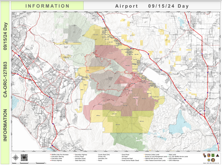
Airport Fire Incident Update 09 15 2024
Related Incident:
Publication Type: News
Location: Trabuco Canyon, CA
Personnel: 1941
Start Date: 9/9/ 2024 01:00pm
Cause: Human
Size: 23,519 acres
Percent contained: 19%
The Airport fire remained within its existing footprint overnight. Firefighters have been able to access previously inaccessible areas around Trabuco Canyon Road and construct direct lines. In the canyon above Lake Elsinore, both direct and indirect lines have been built, and direct lines have also been constructed west towards El Cariso. Structure protection measures have been implemented at the Lazy W Ranch by adding sprinkler protection. Containment lines are being reinforced in various areas, including Bell Canyon, along Trabuco Canyon Road, and in the canyon above Lake Elsinore.
Damage Inspection Teams are currently inspecting structures along the Ortega corridor. This process is expected to take several days to complete. Yesterday, Riverside County announced changes to evacuation zones, moving some areas from orders to warnings.
While the weather has been favorable with cooler temperatures, drizzle, and light showers, Modjeska Peak remains dry, and there is a risk of surface fires above 4,000 feet. The smoldering vegetation at higher elevations still poses a threat due to its potential to roll downhill and ignite unburned vegetation.
The weather forecast for the next few days is favorable for firefighting efforts. Tonight, thick fog and high humidity are expected, which can help slow the spread of the fire. On Sunday and Monday, cooler temperatures and light rain are predicted, providing additional relief. The overall conditions should be conducive to containment efforts. The combination of high humidity, cool temperatures, and light rain is expected to significantly aid in controlling the fire.

_0.jpg?VersionId=NdjtbviSKasXk5E2HATC51t6__nCqXXv)
.jpg?VersionId=2BSh4Ek7L3aatEZ5o_drLMK1Lyq9781M)
Short Draw Fire Daily Update 09 15 2024
Related Incident:
Publication Type: News
Key Messages
All evacuation warnings and notices issued by the Powder River County Sheriff's Office and Campbell County Sheriff's Office have been rescinded.
The Montana DNRC County Assist Team and local agencies have been connecting with affected landowners to provide available resources. For information on post-fire relief, please visit: https://www.uwyo.edu/barnbackyard/resources/wildfire.html.
Current Status
Fire crews successfully conducted a burnout operation on the northwest side of the fire to connect and reduce an unburned pocket of vegetation. Hand crews, engine teams, and dozers have established control lines along the southeast and western perimeters. Additional control lines are expected to be established along the fire line throughout the day. Crews will continue patrolling and working inward from these lines to suppress hotspots. On the southwestern side, fire activity remains ongoing with hotspots and isolated torching, which is expected due to changing winds. Crews are actively monitoring this area and working to contain any flare-ups. Structure protection efforts are ongoing to ensure the safety of residents and valuable assets.
Weather and Fire Behavior
Sunday's weather forecast includes light winds, low humidity and temperatures reaching the high 80s. Winds will shift from the southeast at 10-15 mph during the day. By Sunday night, temperatures will drop to around 57 degrees, and winds are expected to increase, with gusts reaching up to 25 mph.
The fire, initially spread by strong winds, has left many unburned pockets of green vegetation within its interior. Over the next few days these isolated fuel pockets are expected to burn and torch in the coming days due to changing winds.
Evacuations And Closures
All evacuation warnings and notices associated with the fire area have been rescinded. Please avoid the fire area as crews and aerial resources continue fire suppression efforts. The roads remain closed to non-local traffic. Ensuring firefighter safety and protecting life and preservation of grazing lands are most important.
There is a temporary flight restriction (TFR) over the fire area. For firefighter safety, please do not fly unmanned aerial systems in the area.
Coffee Pot Fire Daily Update 09 15 2024
Related Incident: Coffee Pot Fire
Publication Type: News
Command: SACIMT2
Fire Size: 14,081
Percent Contained: 79%
Personnel: 833
Cause: Lightning
Start Date: Saturday, August 3, 2024, at 10:05 a.m.
Location: Southeast of Three Rivers, CA
CURRENT SITUATION: Southern Area Complex Incident Management Team Two assumed command of the Coffee Pot Fire at 7:00 a.m. this morning, Sunday, September 15th. Due to the current condition and successes on the ground, the incident is no longer being managed in unified command with CalFire.
Yesterday, firefighters continued to make progress in the northeastern section of the fire. Crews worked on the control line in the steep terrain on the north side of Horse Creek and continued to monitor and mop-up the lines from the East Fork Kaweah River to Scratch Creek. Crews around the remainder of the fire perimeter continued to hold and patrol the lines, backhaul unneeded equipment, and mop-up farther into the burned area. Crews also worked in the communities along Mineral King Road; chipping smaller materials, and removing snags and hazardous trees as a part of contingency planning.
Today, firefighters will continue handline construction around Horse Creek and monitor the fire as it slowly consumes fuel inside the control lines. Aircraft will continue to support the work on the ground, dropping water to cool hot spots where needed. Crews will continue mop-up efforts; gridding for hot spots and cutting and piling debris to secure the line on the southern, western, and northwestern perimeter of the fire. Contingency work will also continue along Mineral King Road east to Silver City.
WEATHER: A strong low-pressure system will move over the region tomorrow. Ahead of that transition expect a slight decrease in temperature today, with colder conditions overnight. Tomorrow, cold weather will move into place, dropping temperatures well below normal for this time of year. There will be a slight chance of light precipitation (snow possible above 8,000 feet), but a better chance exists later in the week.
SMOKE IMPACTS: Expect similar conditions today as yesterday throughout the outlook area. Hammond will continue to see MODERATE air quality conditions, while areas far north and south of the fire will be in GOOD air quality today. Areas in the Owens Valley can expect MODERATE air quality conditions today, with a majority of the smoke impacts being from the fires to the south of the Coffee Pot fire. For more information on current wildfire smoke impacts in your community, please visit AirNow.gov or fire.airnow.gov.
EVACUATION NOTICES: The Tulare County Fire Department has issued Evacuation WARNINGS for zones TLC-E094-B, TLC-E094-C, TLC-E094-D, TLC-E094-E, and TLC-E095. To find your zone, please refer to: protect.genasys.com.
FIRE INFORMATION: A Public Information Officer will be at the Three Rivers Village Market daily from 11:00 a.m. to 4 p.m. to provide fire information and answer questions.
BLM AND PARK CLOSURES: The portion of South Fork Drive within Sequoia and Kings Canyon National Parks and trails accessed from the road, including the Ladybug and Garfield Grove Trails, are closed. Recreational access to the Mineral King area of Sequoia National Park is closed to the public. This applies to Mineral King campgrounds, trailheads, and area trails. All other areas of the parks are open but are likely to be impacted by varying levels of smoke and poor air quality. Park closure information is available online at nps.gov/seki. The Bureau of Land Management has also issued a closure of the Case Mountain Extensive Recreation Management Area at blm.gov/press-release.
PUBLIC NOTICE: Wildfires are a no-fly zone for unauthorized aircraft, including drones. If you fly, we can’t. For more information, visit knowbeforeyoufly.org.
Buck Creek and Bowman Well Fire Update 09 15 2024
Related Incident: Buck Creek Fire
Publication Type: News
Buck Creek Size: 5,657 acres | Reported Date: September 7 | Cause: Lightning | Containment: 3%
Bowman Well Size: 2,853 acres | Reported Date: September 6 | Cause: Lightning | Containment: 97%
Total Resources Personnel: 675 | Crews: 17 | Engines: 35| Water Tenders: 16 | Heavy Equipment: 15 | Helicopters: 5
(Silver Lake, Ore.) – The Buck Creek Fire started in heavy timber within the Yamsay Mountain Semi-Primitive Area on the Fremont-Winema National Forest, about 13 miles southwest of Silver Lake, Ore. The fire spread north and east into managed timber stands with brush and grass understory and is now about 11 miles from the community of Silver Lake. The Bowman Well Fire was burning in sage brush, grass, and juniper on lands administered by the Bureau of Land Management about 3 miles northwest of Christmas Valley, Ore. All constructed fire lines on both fires held during the windy conditions yesterday and last night. Public and firefighter safety remain the top priority on these incidents.
Buck Creek: Yesterday, winds from the west resulted in increased fire activity on the south edge of the fire near Antler Horse Camp. Helicopter bucket drops aided firefighters as they worked to limit fire growth. In the northwest corner near Buck Creek just south of Rodman Rock, firefighters successfully conducted tactical firing operations. These efforts removed unburned fuels from the fire’s edge to the constructed handline, where it was contained. Hand crews and dozers constructed fire line along the west flank in the vicinity of Buck Ridge. Across the north, northwest and northeast edges (about one mile west of Forest Road 3038), day and night crews continued to improve and mop up along the dozer lines. They also extended hose lays along the constructed fire line to the fire’s most eastern point. On the southern flank, dozer operators built fire line directly on the fire’s edge, near Horse Antler Camp. Six smokejumpers and a twenty-person crew continued to extend hand line and fire hose from near the fire’s origin at Bridge Creek, eastward along the fire edge. These crews have been spending their nights in this difficult-to-access part of the fire. Yesterday, a Rapid Extraction Medical (REM) module joined the crews via the Blue Buck Trail so emergency medical assistance is available at all times.
Today, crews will extend hand line and dozer line on the west and south flanks of the fire. Firefighters will also set up pumps and install hose along constructed lines to aid in mop up activities. If conditions permit, more tactical firing operations will take place on the north flank of the fire. Cooler, wet weather and winds from the north may provide firefighters with opportunities to make greater progress on suppression activities. Aviation resources remain available to assist as conditions allow.
Bowman Well: Yesterday, firefighters patrolled lines to ensure none were threatened by fire activity. Grading restored most roads used to access the fire to pre-suppression condition. Firefighters will patrol containment lines and equipment operators will grade roads again today. As containment increases, excess firefighting resources are being shifted to the Buck Creek Fire.
Evacuations: In coordination with fire managers, the Lake County Sheriff has established evacuations for the Buck Creek Fire. All evacuations for the Bowman Well Fire have been lifted. Go to www.lakecountyor.orgfor details about evacuation levels.
Weather: Today, it will be cooler and damper, with the maximum temperature in the 50s and humidity also in the 50s. There will be cloud cover all day, but only 1/10 inch of rain is predicted.
Safety: Firefighting equipment and personnel are present on local roads. Fire managers ask the public to drive attentively and to remain clear of the fire areas. The public also plays an important role in preventing the next wildfire by using caution with all ignition sources. For prevention tips visit, https://keeporegongreen.org. Current fire danger is extreme and restrictions are in place within the Fremont-Winema National Forest. More information can be found at https://www.fs.usda.gov/fremont-winema.
Closures: A forest closure order is in effect for the area around the Buck Creek Fire. For the complete order and map, go to: https://www.fs.usda.gov/fremont-winema. Christmas Valley Airport is being used as the helibase for fire operations and is temporarily closed to general aviation. A temporary flight restriction remains in place over the Buck Creek Fire.
Smoke: Smoke from multiple fires around the region is affecting air quality. For more information on smoke conditions and strategies on limiting exposure, go to: www.oregonsmoke.org or www.AirNow.gov.