
Coffee Pot Fire Evacuation Update 09 17 2024
Related Incident: Coffee Pot Fire
Publication Type: Announcement
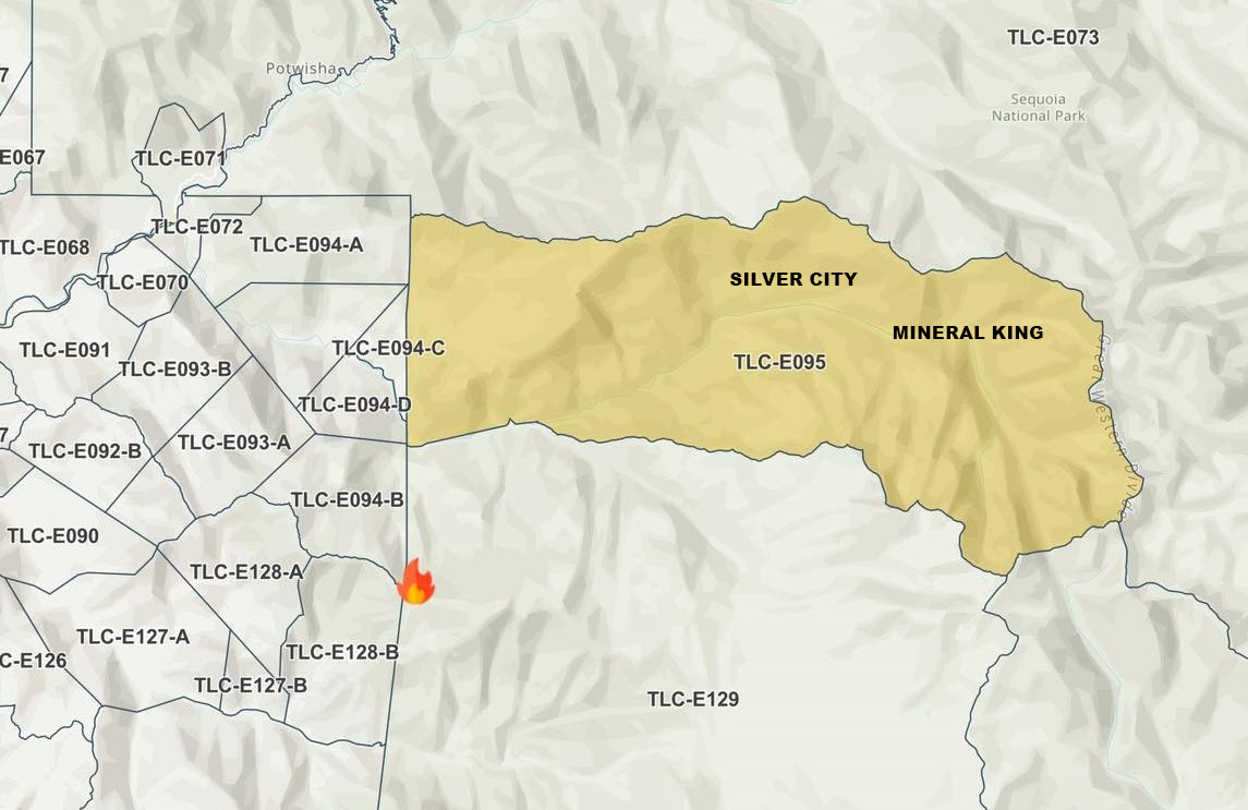
Tulare County Fire Department lifts Coffee Pot Fire evacuation warnings for the following areas effective Tuesday, Sept. 17, 2024.
Zones TLC-E094-B, TLC-E094-D and TLC-E094-C. The area includes east of River Hill, north of Case Mountain, west of Mitchell Ranch, and the community of Oak Grove. West of the National Park Boundary, north of the East Fork of the Kaweah River, east of Oak Grove. The area south of the East Fork of the Kaweah River, approximately a half mile southeast of Oak Grove, just below Mineral King Road, and follows the river east to the southern border of the Genasys zone. North of South Fork Drive, east of Skyline Drive (Salt Creek, fire control road), south of Mineral King Road, and west of the National Park Boundary.
Please refer to the Genesys website for a more detailed area description: protect.genasys.com.
Siphon Fire Morning Update 09 17 2024
Related Incident: Siphon Fire
Publication Type: Announcement
SiphonFire Morning Update:
The Siphon Fire is currently 15,527 acres with 58% containment. Crews continue to patrol and monitor the fire’s perimeter and improve existing firelines. Dry conditions along with cooler temperatures are expected through midweek. There are 60 personnel assigned to the fire including 7 engines and 2 water tenders.
A Trails and Road Emergency Closure Order has been implemented to provide for public health and safety due to firefighting operations and fire danger associated with the Siphon Fire on the #TontoNF. Closed trailheads include First Water Trailhead, Crosscut Trailhead, Broadway Trailhead and Peralta Trailhead. This order shall be in effect from Sept. 16, 2024, at 8 a.m. through Sept. 30, 2024, at 6 p.m., unless rescinded. For a copy of this Order, visit: https://www.fs.usda.gov/alerts/tonto/alerts-notices
Maricopa County has moved residents from GO status and lifted the evacuation order. The roadblock has been removed by Arizona Department of Transportation and SR 88 (Apache Trail) is open.
Pearl Fire Daily Update 09 17 2024
Related Incident:
Publication Type: Announcement
At 6 a.m. on Tuesday, Sept. 17, 2024, the US Forest Service Type 3 Incident Management Team took command of the Pearl Fire. The fire is located approximately 5 miles northwest of Red Feather Lakes and currently estimated at 128 acres with 0% containment. There was no perimeter growth overnight. Larimer County Sheriff's Office determined that the fire originated on private property and was human caused.
Multiple air resources dropped water and fire retardant throughout the day yesterday. Over 75 ground resources are on scene working with aviation assets. Airplanes and helicopters will be working to help secure the fire perimeter and protect values at risk. Low temperatures and higher humidity levels are expected throughout the day. Windy conditions will be possible with 30 to 40 mph gusts across the fire area.
Larimer County Sheriff's Office will continue to operate the Joint Information Center and provide information about evacuation notices, animal evacuations and road closures. For evacuation information visit https://www.nocoalert.org/ or text LCEVAC to 888777. The Joint Information Center can be reached at (970) 980-2500.
For more information on the Pearl Fire visit InciWeb and for the latest updates, follow us on Facebook and Twitter to watch our update videos. To receive email updates on this fire, join our email list and select Forest Health & Fire: North of Hwy 14 to Wyoming Border (Red Feather Lakes).
Diamond Complex and Middle Fork Fire Update 09 17 2024
Related Incident: Middle Fork Fire
Publication Type: News
Current Situation: Firefighters, crews, and heavy-equipment operators made great progress in suppression repair operations around the Diamond Complex on Monday. With favorable weather conditions over the past several days, personnel and equipment have been completing repair projects around this large-scale complex. Another weather system with rain is forecasted through Wednesday. Crews plan to continue their operations during this weather event as it is safe to do so.
Diamond Complex: With all the fires being widespread across the diverse forest landscape, personnel and equipment are fanned out in all divisions with suppression repair tasks to complete. Most of the hand-constructed control lines have been repaired. Heavy-equipment operators and hand crew are repairing dozer-constructed control lines and stream crossings. Dead hazard trees are being cut down and removed while wood chippers are processing the slash. Road graders continue to repair wash boarded forest roads while crews clean out and repair culverts and catch basins. The goal of all these important repair operations is to return to the forest and infrastructure to as much of a pre-fire condition as possible by removing fire-suppression features as well as protecting streams and waterways from soil-erosion damage.
The Diamond Complex includes 33 fires in the Umpqua National Forest, 31 of which are 100% contained. The remaining two fires that are not fully contained are the Pine Bench Fire (3,976 acres, 66% contained) and the Potter Fire (3,428 acres, 76% contained).
Middle Fork Fire: At 6:00 p.m. today, California Interagency Incident Management Team 14 will transfer command of the Middle Fork Fire back to Crater Lake National Park. The fire has remained within its current perimeter for an extended period with no further growth expected. The fire is currently unstaffed and in patrol status. All suppression repair related to the incident has been completed. This will be the last update for the Middle Fork Fire. All future information concerning this incident will be disseminated by Crater Lake National Park Public Affairs Officer Marsha McCabe (541-594-3091, marsha_mccabe@nps.gov). Crater Lake National Park is open; however, three fire-related trail closures are in effect.
Forest Closure: Umpqua National Forest lands, roads, and trails around the Diamond Complex fires are temporarily closed (with several exemptions) under Forest Order 06-15-24-07. You are responsible for knowing where you are in relation to the closed areas, so be prepared and view the order and map prior to recreating on your public lands.
Fire Restrictions: On the Umpqua National Forest, fire danger is set at High and Public Use Restrictions Level 2 are in effect. Campfires must be in Forest Service constructed fire rings or fireplaces in designated sites and are not allowed in dispersed sites or in wilderness areas.
Diamond Complex (Umpqua National Forest)
Size: 11,141 acres
Containment: 86%
Personnel: 425
Resources: 5 crews | 1 helicopter | 8 engines | 4 dozers | 13 water tenders | 3 masticators | 7 excavators
Middle Fork Fire (Crater Lake National Park)
Size: 5,286 acres
Containment: 70%
Personnel: 0
###
Next update to be released 9-19-2024
Fossil Complex Daily Update 09 17 2024
Related Incident: Fossil Complex
Publication Type: News
Wetting Rain Falls On the Service Fire
SPRAY, Ore. – Night shift added depth through mop up, thickening the rind up to 200’ in some areas. Mop up is expected to continue over the next few days, and despite the wetting rains, heavy fuels continue to smolder underground and need to be uncovered and extinguished before pushing toward the interior. Trees weakened by the fire are being removed, as a safety measure, where firefighters will be working.
An inventory of the firelines built during suppression is underway to map places where the suppression activity disturbed the soil and suppression repair work is needed.
Soil disturbances of note are berms along dozer lines and ruts from heavy equipment that are likely to collect or channel water, which can degrade soil or cause erosion. The removal of berms and installation of water bars or scattering debris, called suppression repair, helps the ecosystem recover and protects watershed quality.
Southwest winds of 5-9 mph gusting to 16 mph becoming West-Southwest 10-15 mph gusting to 25 mph on ridgetops. The shift of wind direction has the potential to uproot trees that have been weakened by the fire. Temperatures of 55-60 degrees today.
Videos: Recordings of the Daily Operations Updates and other stories are available at: https://www.youtube.com/@FossilComplex.
Evacuation: Level 3 evacuations remain inside the perimeter of the Service Fire. For the most recent evacuation levels please go to: https://www.facebook.com/WheelerCountySheriffsOffice/
The Two Cabin, Holmes, Kinzua and Canyon Fires are all in patrol status.
FIRE AT A GLANCE
Fossil Complex
Total Size: 24,446 acres
Two Cabin-253 acres
Canyon-192 acres
Kinzua-96 acres
Holmes-15 acres
Service- 23,890
Containment: 28%
Cause: Lightning
Current Cost: $20.1M
All Resources
Hand Crews: 41
Engines: 51
Water Tender: 17
Dozers: 12
Skidgen: 7
Excavator: 2
Masticator: 1
Total Resources: 1,240
Aerial Resources
Type 1: 3
Type 2: 5
Type 3: 3
UAS 3: 1
Evacuations:
Level 3: 11 addresses https://www.facebook.com/WheelerCountySheriffsOffice/
ODF Incident Commander:
Matt Howard
Incident Management Team 2
Bachelor Complex Flat Top and Firestone Fires Update 09 17 2024
Related Incident: Bachelor Complex FiresFlat Top and Firestone Fires
Publication Type: News
Northwest 3 Complex Incident Management Team
Lonnie Click ~ Incident Commander
September 17, 2024
Bachelor Complex, Flat Top and Firestone Fires Update
September 17, 2024
Quick Facts: Bachelor Complex
Size: 10,963 acres
Start Date: Sept 8, 2024
Location: 20 miles SW Bend, OR
Personnel: 623
Quick Facts: Firestone & Flat Top Fires
Firestone Size: 10,935 acres
Start Date: Sept 6, 2024
Location: North of Fort Rock, OR
Flat Top Size: 35,453 acres
Personnel: 294
Yesterday, firefighters took advantage of favorable weather conditions and moderated fire behavior on the Bachelor Complex, Flat Top and Firestone Fires. On the Little Lava Fire, firefighters constructed fireline along the western, southern and northern flanks of the fire, conducted successful burnout operations along the southern perimeter to further secure control lines and continued mop-up operations. On the Firestone Fire, mop-up continued on the western and eastern flanks of the fire and direct handline was constructed south of Forest Service Road (FSR) 650. Mop-up operations and hazard tree felling continued on the Flat Top Fire.
Bachelor Complex: Mop-up operations are complete on the Backside and 911 incidents and both fires will continue to be monitored by air. The Lucky Butte Fire is also being monitored by unmanned aerial systems (UAS). Mop-up operations, hazard tree removal and suppression repair work will continue along the western and southern perimeters of the Little Lava Fire. Hand and dozer line construction is ongoing along the northern flank working west from FSR 45. Firefighters are also constructing indirect fireline along a portion of the southern edge where terrain is too rough for heavy equipment or firefighters to construct direct control lines along the fire’s edge. Crews plan to conduct strategic burning operations along this section of indirect line when weather conditions are favorable to secure the line by removing fuel ahead of the fire.
Flat Top Fire: Today, firefighters will continue to mop-up and secure the perimeter to ensure that fire remains within the established control lines. Crews will continue to monitor for heat within the fire perimeter and extinguish any hot spots as needed. Resources are also removing hazard trees along road systems and near the fire’s edge and starting to repair suppression activities around the perimeter.
Firestone Fire: Today, firefighters will continue mop-up operations moving 50-100 feet into the interior of the fire perimeter to strengthen the control lines. Resources are identifying and removing hazard trees along control lines and road systems. Crews are also extinguishing sources of heat directly along the fire perimeter where possible and are constructing indirect control lines in areas with lava flows, pumice soils and other challenging terrain features along the north flank.
Weather and Fire Behavior: Today, fire behavior is expected to be more active than yesterday due to lower relative humidity levels. Winds will be out of the west, northwest gusting up to 20 mph on the Flat Top and Firestone incidents and 20-25 mph over the Bachelor Complex. There is a 5% chance of rain overnight.
Evacuations: Emergency management and fire officials are reevaluating evacuation levels daily. Level 3 evacuations mean “Go Now,” Level 2 means “Be Set” and Level 1 means "Be Ready.” To view current evacuation levels, please visit the Deschutes County Emergency Information Interactive Map at: http://www.deschutes.org/emergency. For Lake County evacuation information, please visit: https://www.lakecountyor.org/flat_top.php.
Closures: There are two emergency closure areas on the Deschutes National Forest for these fires. View the updated closure orders and maps on the Deschutes National Forest site at: https://www.fs.usda.gov/alerts/deschutes/alerts-notices.
Facebook: https://www.facebook.com/deschutesnationalforest/
InciWeb:
https://inciweb.wildfire.gov/incident-information/ordef-bachelor-complex-fires
https://inciweb.wildfire.gov/incident-information/ordef-flat-top-and-firestone-fires
YouTube: https://www.youtube.com/@CentralOregonFireInfo?app=desktop
Fire Information Line: (541) 249-9829, 8:00 a.m. to 8:00 p.m.
Smoke & Air Quality Information: fire.airnow.gov
Coffee Pot Daily Update 09 17 2024
Related Incident: Coffee Pot Fire
Publication Type: News
Command: SACIMT2
Fire Size: 14,086
Percent Contained: 79%
Primary Strategic Control Line: 96%
Personnel: 597
Cause: Lightning
Start Date: Saturday, August 3, 2024, at 10:05 a.m.
Location: Southeast of Three Rivers, CA
CURRENT SITUATION: Yesterday’s weather conditions, with cooler temperatures and higher relative humidity, reduced fire activity. In the northeastern section of the fire, crews continue to reinforce the control lines along the East Fork Kaweah River towards Scratch Creek. Crews will be strengthening control lines in the area around Homers Nose and in the Horse Creek drainage. Along the southern and western flanks of the fire, crews are patrolling, mopping up and monitoring for hot spots. Crews continue to work on removing flammable materials and hazardous trees along Mineral King Road. Suppression repair, minimizing soil erosion, preventing impacts to water quality, and restoring pre-fire conditions as much as possible, was completed along the western control line. As crews continue to patrol the control lines, unneeded equipment will be backhauled from the southern and western flanks of the fire.
WEATHER: Temperatures will remain cooler than normal today but are expected to be 10 degrees warmer than yesterday. The expected high in areas over 5,000 feet in elevation is 61 degrees. Conditions will be mostly sunny. Relative humidity will bottom out around 50%. Sustained west winds will reach 3-7 mph with gusts of 12-18 mph. Potential for rainfall, with wetting amounts included, increases on Wednesday and Thursday.
SMOKE IMPACTS: Expect similar air quality conditions today, with little smoke production. All communities in the outlook area will be in the GOOD range throughout the day. Some MODERATE conditions late afternoon in Hammond and Springville possible, based on fire activity. For more information on current wildfire smoke impacts in your community, please visit AirNow.gov or fire.airnow.gov.
EVACUATION NOTICES: The Tulare County Fire Department has issued Evacuation WARNINGS for zones TLC-E094-B, TLC-E094-C, TLC-E094-D, TLC-E094-E, and TLC-E095. To find your zone, please refer to: protect.genasys.com.
FIRE INFORMATION: A Public Information Officer will be at the Three Rivers Village Market daily from 11:00 a.m. to 4 p.m. to provide fire information and answer questions.
BLM AND PARK CLOSURES: The portion of South Fork Drive within Sequoia and Kings Canyon National Parks and trails accessed from the road, including the Ladybug and Garfield Grove Trails, are closed. Recreational access to the Mineral King area of Sequoia National Park is closed to the public. This applies to Mineral King campgrounds, trailheads, and area trails. All other areas of the parks are open but are likely to be impacted by varying levels of smoke and poor air quality. Park closure information is available online at nps.gov/seki. The Bureau of Land Management has also issued a closure of the Case Mountain Extensive Recreation Management Area at blm.gov/press-release.
PUBLIC NOTICE: Wildfires are a no-fly zone for unauthorized aircraft, including drones. If you fly, we can’t. For more information, visit knowbeforeyoufly.org.
Buck Creek Fire Update 09 17 2024
Related Incident: Buck Creek Fire
Publication Type: News
(Silver Lake, Ore.) – The Buck Creek Fire started in heavy timber within the Yamsay Mountain Semi-Primitive Area on the Fremont-Winema National Forest, about 13 miles southwest of Silver Lake, Ore. The fire spread north and east into managed timber stands on National Forest lands with brush and grass understory and it remains about 11 miles from the community of Silver Lake. The diligence and hard work of firefighters and equipment operators these past ten days has resulted in construction of continuous line around the perimeter of the fire. Public and firefighter safety remain the incident’s top priority.
Buck Creek: Yesterday, continued cool weather and light rain provided favorable conditions for firefighters to mop up hot spots and secure previously constructed fire line around the fire perimeter. On the west edge of the fire, hand crews and dozer operators completed construction of fire line from Rodman Rock over Buck Ridge to Buck Creek. Across the north flank, day and night crews improved and mopped up along established dozer lines. On the northeast edge of the fire along constructed fire lines, firefighters used Unstaffed Aerial System (UAS/drone) flights to document hidden hot spots for extinguishment by crews on the ground. On the south edge of the fire, hand crews methodically built fire line and conducted mop up operations in steep terrain and through a substantial amount of dead and down material.
Today, crews are improving completed hand line and are using water pumped from nearby streams to mop up hot spots in the difficult terrain northeast from Antler Horse Camp and southeast from near the Blue Buck Trail. The camp has not been damaged by the fire; however, it remains within a closure area. Firefighters in other areas are also extinguishing hot spots along the remainder of the constructed fire line. Firefighter safety is the top priority as mop up operations continue along fire lines where hazardous trees and hot ash pits remain a concern. Aviation resources remain available to assist on-the-ground firefighters as conditions allow.
Evacuations: In coordination with fire managers, the Lake County Sheriff has established evacuations for the Buck Creek Fire. Go to www.lakecountyor.org for details about evacuation levels.
Weather: Today, sunshine and a westerly breeze will promote drying. Another cold front will move through the area tonight, with a slight chance of showers expected.
Safety: Firefighting equipment and personnel are present on local roads. Fire managers ask the public to drive attentively and to remain clear of the fire areas. The public also plays an important role in preventing the next wildfire by using caution with all ignition sources. For prevention tips visit: https://keeporegongreen.org. Current fire danger is extreme and restrictions are in place within the Fremont-Winema National Forest. More information can be found at: https://www.fs.usda.gov/fremont-winema.
Closures: A forest closure order is in effect for the area around the Buck Creek Fire. For the complete order and map, go to: https://www.fs.usda.gov/fremont-winema. Christmas Valley Airport is being used as the helibase for fire operations and is temporarily closed to general aviation. A temporary flight restriction is in place over the Buck Creek Fire.
Smoke: Smoke from multiple fires around the region is affecting air quality. For more information on smoke conditions and strategies on limiting exposure, go to: www.oregonsmoke.org or www.AirNow.gov.
Willamette Complex North Daily Update 09 17 2024
Related Incident: North Willamette Complex
Publication Type: News
Willamette Complex North Update
Boulder Creek, Ore, Linton Creek, 374 and Pyramid Fires
Date: Tuesday, September 17, 2024
InciWeb: https://inciweb.wildfire.gov/incident-information/orwif-north-willamette-complex
Willamette Complex North Facebook Page:
https://www.facebook.com/profile.php?id=61565845313387
Email:2024.WillametteComplex.North@firenet.gov Information line: 541-208-1262 Hours: 8 a.m. to 8 p.m.
Overview: Tuesday’s rain showers will reduce fire activity while also limiting ground and aerial firefighting efforts. Currently, chipping and fuel removal is a significant focus of many crews in the complex. This work is critical because, as the Northern Rockies Complex Incident Management Team 6 Operations Chief Manny Mendoza said, “The current fire behavior won’t get us it’s what’s in the future.” The possibility of changes in future conditions is why all fires remain under a full suppression strategy.
Boulder Creek Fire Evacuation Notices
Evacuation levels were reduced to Level 1 by the Lane County Sheriff’s Office at 2pm on Monday afternoon: LEVEL 1 (BE READY) EVACUATION NOTICE: South of Highway 126 from milepost 53.5 east to Scott Creek Road and Horse Creek Road east of Foley Springs, Foley Springs, Forest Service Road #302, Belknap Springs Road South, Camp Yale Road, Yale Lane, North of Highway 126 East from the east end of Drury Lane to the end of North Belknap Springs Road.
Evacuation Notice Source: www.LaneCountyOR.gov
Boulder Creek: 511 acres, 0% contained
Located 5 miles east of McKenzie Bridge. Safe travel along the OR 126 highway is a priority. Crews continue working along OR 126 to extinguish areas of heat and evaluate and address fire-weakened trees along the road corridor. The Boulder Creek area continues to hold heat and is challenging to access due to steep terrain with heavy fuels.
Ore: 3,475 acres, 76% contained
Located 7 miles northeast of Blue River. Following the good firefighting work that has been accomplished, crews continue chipping efforts and removing combustible material.
374: 58 acres, 0% contained and Linton Creek: 1,301 acres, 0% contained
Both of these fires are located in the Three Sisters Wilderness. The fires received a wetting rain Monday. Crews will continue today work on improving trails to use as fire line, prioritizing the Pacific Crest Trail.
Pyramid: 1,311 Acres, 98% contained
East of Middle Santiam Wilderness. Crews are improving containment lines and are working to reduce burnable fuels through mechanized mastication and chipping.
Road Closures: OR 126 is open to one-lane traffic between mileposts 13 and 19.5 (intersection with OR 242). OR 242 remains closed to all traffic between the intersection with OR 126 and the Dee Wright Observatory (mileposts 55 to 75), due to the Linton Creek Fire. Use an alternate route; do not divert onto forest roads to avoid closures.
Check for updates at: https://tripcheck.com/
Willamette National Forest Area Closures: Due to fire activity in the McKenzie River Ranger District, the Linton Creek Fire closure area includes Boulder Creek, 374, Roundtop, as well as other fires on the Middle Fork Ranger District including Young Grasshopper and Lowell Creek fires. Source: https://www.fs.usda.gov/detail/willamette/alerts-notices/?cid=fseprd552029.