
Wood Lake Fire Facts Sheet for Saturday September 14 2024 09 14 2024
Related Incident:
Publication Type: News
Wood Lake Fire Facts Sheet
Date: September 14, 2024 Size: 27 acres Containment: 0%
Cause: Under Investigation-Human Caused* Start Date: September 10, 2024
Fire Information:
Inciweb page: https://inciweb.wildfire.gov/incident-information/mnsuf-wood-lake-wildfire
Superior NF Facebook: https://www.facebook.com/SuperiorNF
Twitter/X: https://x.com/SuperiorNF
Sign up for Superior NF Fire Information notices and news
Current Status and Resources: Firefighters continue to suppress the fire, strengthen holding lines with pumps and hose lays, use natural features, and backfire with hand ignition when needed to reduce spotting potential near the perimeter or containment line. Yesterday and overnight, fire activity included group tree torching, especially in pockets of spruce budworm infested balsam fir. Aircraft are working the fire to prevent more intense crown and running fire behavior. The National Preparedness Level remains at 5.
Planned Actions: Resources will scout for new containment line locations while continuing to strengthen existing lines on the west side and hold eastern lines. Additionally, firefighters continue to analyze contingency planning around the Moose Lake area, planning that wider perimeter area around the fire.
Closures: The Superior National Forest implemented Emergency Closure Order #09-09-24-07 for the public’s health and safety due to the Wood Lake fire within the vicinity of recreation areas. The closure order includes Exhibit A-List of Closed Areas and Exhibit B-Closure map. For the safety of firefighting resources, no drones are allowed near the fire area and are illegal in federally designated wilderness areas.
Weather and Smoke: Today-mostly sunny, high near 78, with a 30% chance of showers and thunderstorms after 4pm. South winds 5-15 mph with gusts up to 20 mph. Overnight-a 10% chance of showers before 7pm, otherwise mostly cloudy. Low of 58. South wind at 5 mph, with gusts up to 15 mph. Sunday-Partly sunny. High of 79. South wind 5-10 mph, with gusts up to 20 mph
Overall air quality in the Ely area will be GOOD today. Wildfire smoke from Canada is possible in the area. https://www.airnow.gov/ and https://www.pca.state.mn.us/air-water-land- climate/air-quality-forecast
Fire Summary: On September 10, 2024, around 11:00 a.m. a fire was detected on an island of Wood Lake, located north of County Road 18, within the Boundary Waters Canoe Area Wilderness (BWCAW) of the Superior National Forest. The fire is located in T64, R10, S26 on National Forest System land. An Emergency Closure Order is in effect for 19 locations including BWCAW Entry Point 26 on Wood Lake.
*Superior NF law enforcement staff are requesting any information into the start of the fire. Please email the Superior NF Tipline at SM.FS.SUP-tipline@usda.gov, Superior NF Webpage Tipline. Thank you for your assistance.
Airport Fire Incident Update 09 14 2024
Related Incident:
Publication Type: News
Incident Start Date: 09/09/24
Acreage: 23,410
Containment: 9%
Please see the Related Information below for today's complete update.
Firefighters are making significant strides in establishing a containment line along the Ortega Highway towards Lakeland Village. The continued support from air operations is proving invaluable in aiding firefighters efforts on the ground. By strategically constructing both direct and indirect firelines, firefighters are creating a robust barrier against the fire's spread. The influx of additional resources to the Airport Fire is a positive development, providing much-needed support to the firefighting efforts. Taking advantage of favorable weather conditions, crews are actively building firelines and employing effective tactics. Hand crews are playing a vital role in this endeavor, and the arrival of reinforcements will further strengthen their capabilities. As conditions allow, damage assessments will continue to be conducted near El Cariso by the damage assessment teams.
Yesterday, Riverside and Orange County officials announced additional changes to evacuation orders and warnings related to the fire. These updates reflect the evolving situation on the ground as firefighters continue to make progress in containing the fire. It's important for residents in the affected areas to stay informed about the latest evacuation information and to follow the guidance of local authorities.
While we appreciate the generosity of those who have offered food donations, we encourage you to consider supporting local charities that can better distribute aid to those affected by the fire. These organizations, such as food banks, shelters, and community centers, are equipped to provide essential supplies and services to those in need. By directing your donations to these reputable organizations, you can help ensure that your support is used effectively to assist those impacted by the fire.
An incorrect percentage of containment was reported early this morning, the official correct containment of the Airport Fire is 9%.
Moore Square Complex Update 09 14 2024
Related Incident:
Publication Type: Announcement
Key message
The Fire Area Closure for the area around the Moore Square Complex will be lifted September 14, 2024 at 6 pm due to favorable weather conditions and decreased fire activity. The fire area has experienced a substantial amount of rain over the last 72 hours with continued precipitation in the forecast on Tuesday. If members of the public are entering the Gospel-Hump Wilderness Area please remember that the fire area is still active and there is an increased hazard from fire weakened trees and rolling debris within and around the fire perimeter.
CURRENT STATUS
On September 15, 2024 at 0700 the fire will transfer from Northern Rockies Team 9 to an Incident Commander Type 4 managed through the Nez Perce-Clearwater National Forest. Work has been completed on indirect lines and crews will continue working on removing protection measures on infrastructure as needed. Fire fighting will crews remain in the area to monitor and respond to any changes in the fire and continue to adapt to the changing environment around the fire area.
Closures
The Closure Order will be rescinded on September 14, 2024 at 6 pm. Please be aware of increased hazardous conditions around the fire area.
Specific fire information and maps can be found on Inciweb at https://inciweb.wildfire.gov/incident-information/idncf-moore-square-complex and https://www.fs.usda.gov/detail/nezperceclearwater/home/?cid=fsm91_055753
**Final update for the Moore Square Complex unless fire activity and events warrant it.**
Buck Creek and Bowman Well Fire Update 09 14 2014
Related Incident: Buck Creek Fire
Publication Type: News
Buck Creek Size: 5,542 acres | Reported Date: September 7 | Cause: Lightning | Containment: 0%
Bowman Well Size: 2,853 acres | Reported Date: September 6 | Cause: Lightning | Containment: 95%
Total Resources Personnel: 659 | Crews: 17 | Engines: 33 | Water Tenders: 15 | Heavy Equipment: 14 | Helicopters: 8
(Silver Lake, Ore.) – The Buck Creek Fire started in heavy timber on the Fremont-Winema National Forest about 11 miles southwest of Silver Lake, Ore. in a semi-primitive area of the Forest with limited road access. The Bowman Well Fire has been burning in sage brush, grass and juniper on lands administered by the Bureau of Land Management about 3 miles northwest of Christmas Valley, Ore. Crews continue to make good progress on the Buck Creek Fire and containment on the Bowman Well Fire has reached 95%. Public and firefighter safety remain the top priority on these incidents
Buck Creek: Yesterday, warmer and drier conditions led to creeping and backing fire behavior on the east edge. Day and night shift firefighters mopped up hot spots to secure completed dozer line along the north flank and around Rodman Rock on the northwest corner of the fire. Dozer operators made progress accessing Buck Ridge to install direct line on the west edge of the fire. Felling crews dropped snags and other hazardous trees to provide safer conditions for those working along the roads. Dozer line was extended along the eastern edge of the fire and around spots caused by the extreme fire activity on September 10; helicopter bucket drops aided firefighters with this work. On the southwest edge of the fire, a twenty-person crew was flown in to bolster the efforts of six smoke jumpers who have been installing hand line and hose lays in the southern Bridge Creek area since the fire started.
Today, crews will improve a portion of the Blue Buck Trail (within the Yamsay Mountain semi-primitive area) to provide access for medical evacuation and crew support. Improving this trail will also make it easier for firefighters to install direct fire line along the south and west flanks at locations with the highest probability of success. To support mop-up activities, crews are setting up pumps and installing hoses along constructed lines. As a cold front moves into the area this afternoon, fire activity may increase where winds align with terrain. Aviation resources remain available to assist as visibility allows.
Bowman Well: Yesterday, there was minimal fire activity with no threat to established containment lines. Firefighters patrolled and identified places needing suppression repair and road grading. As containment increases, excess firefighting resources are being shifted to the Buck Creek Fire.
Evacuations: In coordination with fire managers, the Lake County Sheriff has established evacuations for the Buck Creek Fire. All evacuations for the Bowman Well Fire have been lifted. Go to www.lakecountyor.orgfor details about evacuation levels.
Weather: Like Friday, today’s maximum temperature is predicted to be in the mid 70s with minimum humidity in the 20s. A cold front is expected to arrive today with westerly wind gusts up to 20 mph.
Safety: Firefighting equipment and personnel, and livestock are present on local roads. Fire managers ask the public to drive attentively and to remain clear of the fire areas. The public also plays an important role in preventing the next wildfire by using caution with all ignition sources. For prevention tips visit, https://keeporegongreen.org. Current fire danger is extreme and restrictions are in place within the Fremont-Winema National Forest. More information can be found at:
https://www.fs.usda.gov/detail/fremont-winema/news-events/?cid=FSEPRD1188568
Closures: A forest closure order is in effect for the area around the Buck Creek Fire. For the complete order and map, go to: https://www.fs.usda.gov/fremont-winema . Christmas Valley Airport is being used as the helibase for fire operations and is temporarily closed to general aviation. A temporary flight restriction remains in place over the Buck Creek Fire.
Smoke: Smoke from multiple fires around the region is affecting air quality. For more information on smoke conditions and strategies on limiting exposure, go to: www.oregonsmoke.org or www.AirNow.gov.
Siphon Fire Morning Update 09 14 2024
Related Incident: Siphon Fire
Publication Type: News
Fire officials have estimated the #SiphonFire at approximately 15,875 acres with 0% containment. Yesterday, super scoopers conducted water drops to limit the spread of the fire near Weaver’s Needle as the southeast side of the fire was active. The southwest flank of the fire saw very little growth. Today, crews will be monitoring and improving fire lines along SR 88 (Apache Trail). An overflight this morning will conduct aerial mapping of the fire area, and the roadblock will be moved from Mile Marker 201 to Needle Rock Vista for the safety of fire crews during fire suppression operations. The fire is human-caused and under investigation. Resources assigned include 2 handcrews, 11 engines, two water tenders, and a medical team.
The Apache Junction area has moved from SET to READY status. Currently, no communities are under immediate threat. However, residents in the area should remain aware, follow fire updates and messaging from local emergency agencies.
The READY, SET, GO system steps guide Arizonans to get READY by preparing now for what threatens their community, be SET by maintaining awareness of significant danger and to GO, evacuate immediately when the danger is current and life-threatening. For more information or to sign up for alert notifications visit: https://ein.az.gov/ready-set-go
Maricopa County is still under GO status and residents are urged to sign up for emergency alert notifications for the latest updates at https://ready.maricopa.gov/999/Emergency-Management. The public can visit http://ready.maricopa.gov for more information.
Line Fire Daily Status Update 09 14 2024
Related Incident: Line Fire
Publication Type: News
Late Friday night and into the early hours Saturday, Line Fire activity was moderated due to higher moisture levels. The fire did however continue to smolder and creep in dry vegetation, and it made occasional runs in drainages and along slopes. Saturday is expected to be mostly sunny and seasonably cool with poor visibility in the morning. The weather is expected to remain cool over the next several days which will continue to help moderate fire behavior. Firefighters are strengthening control lines and mopping up hot spots.
There are currently 56,100 structures threatened, including 11,400 under Evacuation Orders and 44,700 under Evacuation Warnings. Damage Inspection Teams (DINS) are working in the fire area. So far, they have identified 3 structures that were damaged and 1 that was destroyed. Their inspections include residences, multi-family dwellings, outbuildings, and commercial buildings.
Governor Gavin Newsom has announced that the California National Guard will support the state’s ongoing response to the Line Fire.
Through its activation, authorized under the Line Fire state of emergency, the California National Guard has deployed:
- Four UH-60 Blackhawk helicopters for water bucket dropping operations
- Two C-130 aircraft with Modular Airborne Fire Fighting Systems (MAFFS)
- Four 20-person hand crews (80 soldiers). They will be assigned to the Line Fire on Thursday in support of CAL FIRE.
One military police company to support the San Bernardino County Sheriff’s Department with traffic control points in evacuated areas. For information on the Line Fire, please call (909) 220-4292. The line for media is (909) 881-6949. Additional fire information can be found at: Cabdf Line Fire Information | InciWeb (wildfire.gov).
Governor Newsom proclaims state of emergency in San Bernardino County, secures federal assistance to support response to Line Fire.
Line Fire YouTube PlaylistExternal
Willamette Complex North Daily Update 09 14 2024
Related Incident: North Willamette Complex
Publication Type: News
Willamette Complex North Update
Boulder Creek, Ore, Linton Creek, Pyramid, 374, and Roundtop Fires
Date: Saturday, September 14, 2024
Willamette Complex North - Facebook Page: https://www.facebook.com/profile.php?id=61565845313387
Email: 2024.WillametteComplex.North@firenet.gov Information line: 541-208-1262 Hours: 8 a.m. to 8 p.m.
Overview: Additional fire details are available today after skies cleared enough for crews to use aircraft and heat detection technology to get a sharper picture of the status of fires in the complex. Any increase in acres is due to interior burning. Crews are again taking advantage of opportunities to go direct on the fires. OR 126 was closed for safety but is now back to one lane only. A road closure continues for a section of OR 242. The fires remain under a full suppression strategy. Showers are expected this evening and overnight into Sunday. Light to moderate west wind up to 10 mph is expected with temperatures between 60-70 degrees in the complex.
Boulder Creek Fire Evacuation Notices
LEVEL 3 (GO NOW) EVACUATION NOTICE: Scott Creek Road
LEVEL 1 (BE READY) EVACUATION NOTICE:
South of Highway 126 from milepost 53.5 east to Scott Creek Road and Horse Creek Road east of Foley Springs, Foley Springs, Forest Service Road #302, Belknap Springs Road South, Camp Yale Road, Yale Lane, North of Highway 126 East from the east end of Drury Lane to the end of North Belknap Springs Road
Evacuation Notice Source: Visit www.LaneCountyOR.gov or use this link.
Boulder Creek: 511 acres, 0% contained
Located 5 miles east of McKenzie Bridge. Structure protection work is near completion. Crews are going direct on the fire where safe with a focus on areas near OR 126. Dozer work on the north portion of the fire continues.
Ore: 3,474 acres, 44% contained
Located 7 miles northeast of Blue River. Minimal fire activity. Chipping and removal of fuels continues. Successful firing operations below the 1509 Road were completed and successful in helping to contain the fire.
Linton Creek: 1,301 acres, 0% contained
Located in the Three Sisters Wilderness northeast of Eileen Lake. Heavy fuels continue to burn. Ground and aerial firefighting efforts are being used effectively to secure containment.
Pyramid: 1,311 Acres, 98% contained
East of Middle Santiam Wilderness. The Pyramid is holding within control lines. Securing containment line continues with chipping of burnable fuels. Infrared showed additional scattered heat across the interior of the fire, however only a few smokes were observed.
374: 58 acres, 0% contained
This fire is also in the Three Sisters Wilderness, northwest of Packsaddle Mountain. 14 smokejumpers remain assigned to the fire. Crews are going direct on the fire where possible and working on containment lines.
Roundtop: Less than one acre, 100% contained.
Near the 374 Fire and Little Roundtop Mountain. No heat detected.
Road Closures: OR 126 is now open to one-lane traffic between mileposts 13 and 19.5 (intersection with OR 242). OR 242 remains closed to all traffic indefinitely between the intersection with OR 126 and the Dee Wright Observatory (mileposts 55 to 75), in the area of the Linton Creek Fire. Use an alternate route; do not divert onto forest roads to avoid closures. Check for updates at: https://tripcheck.com/
Willamette National Forest Area Closures: Due to increased fire activity in the McKenzie River Ranger District, the Linton Creek Fire closure area was expanded to include Boulder Creek, 374, Roundtop, as well as other fires on the Middle Fork Ranger District including Young Grasshopper and Lowell Creek fires. Source: https://www.fs.usda.gov/detail/willamette/alerts-notices/?cid=fseprd552029.
Davis Fire Update 09 14 2024
Related Incident: Davis Fire
Publication Type: News
Acres: 5,824 acres
Start Date: 09/07/2024
Location: Washoe Valley, Nevada
Personnel: 710
Containment: 76%
Fuels: Timber
Resources: 10 Crews | 14 Helicopters | 75 Engines | 6 Water Tenders | 4 Dozers
Highlights: Crews on the Davis Fire had another successful day working on increasing containment along the Davis Creek Rd area and Joy Lake area. The hard work of firefighters has allowed the fire containment to steadily increase over the last few days. With an increase of winds today, interior burning may occur in pockets of unburned fuel and the public could see isolated areas of smoke over the next few days. Crews will continue to patrol the fire and address hot spots by extinguishing hot spots with water, stirring burning vegetation with hand tools.
Weather: Expect to experience a drying trend and increased winds in upcoming days. Relative humidity will drop into the teens with winds at approximately 12 mph and gusts up to 22 mph. This will result in the potential for an increase in fire behavior. Temperatures will be much cooler on Sunday, with relative humidity substantially increasing.
Evacuations: We urge everyone to remain vigilant and stay clear of evacuation zones. Crews are working tirelessly to remove hazard trees that may have become unstable during the fire. Stay informed by relying on official information sources. For updates on evacuation statuses please visit: https://perimetermap.com Waste Management will provide one dumpster at the Truckee Meadows Fire Station at 4000 Joy Lake Rd. and one dumpster at US-395 and Eastlake Blvd. for residents who need to discard spoiled food items and other waste.
Donations: While we deeply appreciate the generosity of our community, fire crews do not need additional donations on the Davis Fire. Rest assured, our firefighters and personnel have contracts in place to meet all of their basic needs. As a meaningful gesture, we would be grateful to receive thank you cards or written messages of support that can be displayed during our briefings. These messages would allow firefighters to see and feel the community’s appreciation firsthand. Food and supply donations can be directed to the Food Bank of Northern Nevada. For more information visit: www.fbnn.org
Truckee Meadows Fire Protection District and the Washoe County Sheriffs Office are leading the investigation into the cause of the Davis Fire. If you have credible information, or if you were in the vicinity of the day-use area at Davis Creek Regional Park on September 8th at the start of the fire, contact 775-326-6079 or email: info@tmfpd.us.
To sign up for code red alerts and warning visit https://www.washoecounty.gov/em/RegionalAlerts.php
Middle Fork Fire Update to Closure 36 CFR 15b 09 14 2024
Related Incident: Middle Fork Fire
Publication Type: Closures
Memorandum
Date: September 13, 2024
To: All Park Visitors, Employees and Residents
From: Superintendent, Crater Lake National Park
Subject: Middle Fork Fire, Trail Closure Updates, 36 CFR 1.5(b)
Due to potentially hazardous conditions created by the Middle Fork Fire, the following trails will be closed to entry and use until further notice:
- Bald Crater Loop Trail
- Bert Creek Trail
- Boundary Springs Trail
Crater Lake Visitor and Resource Protection and Fire Management staff will be assessing ongoing conditions as the season progresses.
The trail closures are being implemented to reduce threats to public safety associated with wildland fire hazards.
All other trails in the park are currently open and any previous trail or area closure orders are rescinded. The Pacific Crest Trail is now fully open within the park.
This closure is implemented pursuant to the authority described in Title 36, Code of Federal Regulations 1.5(a)(1), 1.5(b) and 1.5(f). Please contact Public Information Officer Marsha McCabe at 541-594-3091 with any questions or for additional information.
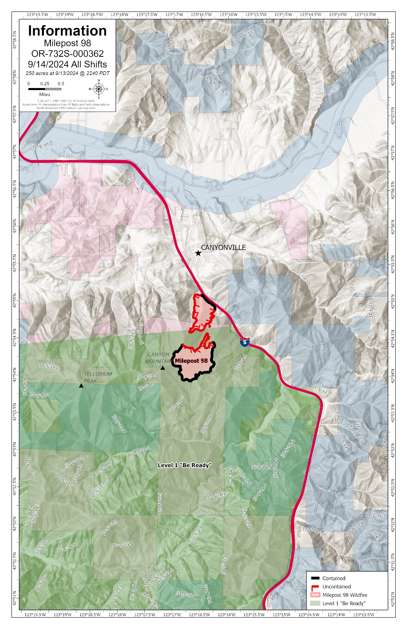
Devils Knob and Milepost 98 Daily Update 09 14 2024
Related Incident:
Publication Type: News
Devil’s Knob and Milepost 98 Fire Update for Saturday, September 14, 2024
KEY MESSAGES:
There has been negligible growth in the acreage of the Devil’s Knob and Milepost 98 fires in the last 48 hours. Fire activity is expected to remain minimal within the interior of the fires, with high moisture levels aiding in efforts on the ground and extensive mop-up operations adding to overall containment on the incidents. This current status has allowed resources to scale back on night operations, with more crews switching to day shifts.
CURRENT STATUS:
Devil’s Knob- Resources: 701, Crews: 21, Engines: 15, Water Tenders: 11
Fire activity remains light despite the recent drier, warmer conditions. Along the southern end of the fire, tethered dozer operations are underway on steep terrain to further improve fire lines. On the east flank, mop-up operations continue in areas of dense vegetation, while containment is progressing along northern and western edges. Suppression rehabilitation of fire-impacted areas around Flat Ranch and Tyson Ranch properties are now complete.
Milepost 98- Resources: 231, Crews: 9, Engines: 10, Water Tenders: 7
On the southern flank, firefighters have successfully mopped up 200 feet into the fire interior. This distance will ensure that there is low probability of fire crossing the perimeter. Completed dozer lines are being rehabilitated to meet local standards as snagging operations continue.
Resources are being moved to assist the Devil’s Knob Fire and other priority incidents in the area as containment increases on the Milepost 98 Fire. Firefighters are monitoring the fire’s perimeter for any remaining hotspots as mop-up operations proceed. CIMT NW 13 and the Oregon Department of Transportation are coordinating efforts to continue to remove hazard trees from the area, focusing efforts along the I5 corridor.
WEATHER / FIRE BEHAVIOR:
Although the fire area experienced drier, warmer temperatures yesterday, fire activity is limited to creeping and smoldering. Similar conditions are expected today. Additional precipitation with cooler temperatures is predicted to return to the forecast starting Sunday, which may trend through Wednesday. High humidity levels are likely to persist for at least the next seven days.
SAFETY AND CLOSURES:
Closures on the Umpqua National Forest can be found at https://www.fs.usda.gov/alerts/umpqua/alerts-notices.
Umpqua National Forst restrictions can be found at https://www.fs.usda.gov/main/umpqua/fire.
Fire Restrictions for Bureau of Land Management can be found on the Oregon-Washington blm.gov page.
Oregon Department of Forestry restrictions can be found at https://www.oregon.gov/odf/fire/pages/restrictions.aspx.
Douglas Forest Protective Association restrictions can be found at https://www.dfpa.net/public-fire-restrictions.
.jpg?VersionId=QwSPOf17YoBCNoUktu.tbb3fjRWqgN.G)