
Community Mitigation Assistance Team Open House in Lowman on Sunday September 15 09 13 2024
Related Incident:
Publication Type: Announcement
Join the Community Mitigation Assistance Team (CMAT) for an open house in Lowman on Sunday!
- September 14, 2024, 4:00pm
- Lowman Volunteer Fire Department, Station 80
- 8000 ID-21, Lowman, ID 83637
Learn about available resources and collaborate on solutions to enhance wildfire resilience.
KXGV Radio for September 13 2024 09 13 2024
Related Incident:
Publication Type: Announcement
KXGV Radio host Swing Man interviews Incident Meteorologist Nick Nauslar and PIO Jaclynn Swope from the Middle Fork Complex fire on Sept.13, 2024.
https://youtu.be/t9sCzNXWGC4?si=5G9MymSG5v0fstKW
Whisky Creek Fire update 09 13 2024
Related Incident: Whisky Creek Fire
Publication Type: News
Central Cascades Interagency IMT
Whisky Creek Fire
Sept. 11, 2024
Fire Information: (541) 208-1743, 8 AM - 8 PM
For links to incident information: https://linktr.ee/whisky_creek.2024
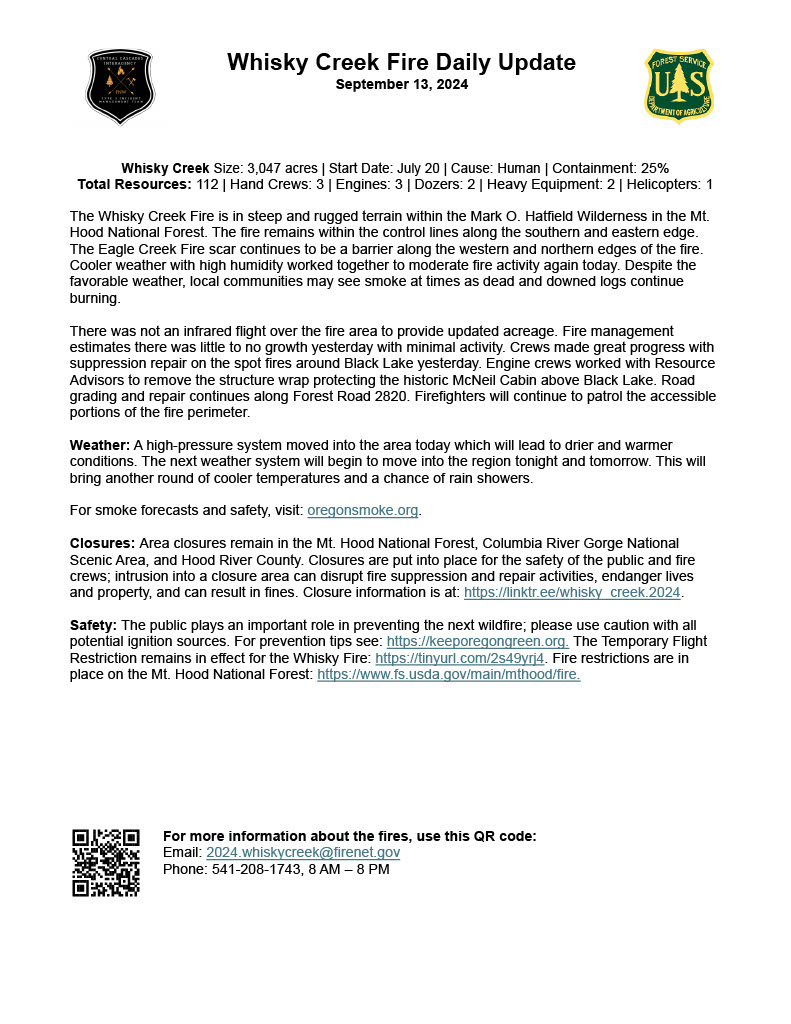
Whisky Creek Size: 3,047 acres | Start Date: July 20 | Cause: Human | Containment: 25%
Total Resources: 112 | Hand Crews: 3 | Engines: 3 | Dozers: 2 | Heavy Equipment: 2 | Helicopters: 1
The Whisky Creek Fire is in steep and rugged terrain within the Mark O. Hatfield Wilderness in the Mt. Hood National Forest. The fire remains within the control lines along the southern and eastern edge. The Eagle Creek Fire scar continues to be a barrier along the western and northern edges of the fire. Cooler weather with high humidity worked together to moderate fire activity again today. Despite the favorable weather, local communities may see smoke at times as dead and downed logs continue burning.
There was not an infrared flight over the fire area to provide updated acreage. Fire management estimates there was little to no growth yesterday with minimal activity. Crews made great progress with suppression repair on the spot fires around Black Lake yesterday. Engine crews worked with Resource Advisors to remove the structure wrap protecting the historic McNeil Cabin above Black Lake. Road grading and repair continues along Forest Road 2820. Firefighters will continue to patrol the accessible portions of the fire perimeter.
Weather: A high-pressure system moved into the area today which will lead to drier and warmer conditions. The next weather system will begin to move into the region tonight and tomorrow. This will bring another round of cooler temperatures and a chance of rain showers.
For smoke forecasts and safety, visit: oregonsmoke.org.
Closures: Area closures remain in the Mt. Hood National Forest, Columbia River Gorge National Scenic Area, and Hood River County. Closures are put into place for the safety of the public and fire crews; intrusion into a closure area can disrupt fire suppression and repair activities, endanger lives and property, and can result in fines. Closure information is at: https://linktr.ee/whisky_creek.2024.
Safety: The public plays an important role in preventing the next wildfire; please use caution with all potential ignition sources. For prevention tips see: https://keeporegongreen.org. The Temporary Flight Restriction remains in effect for the Whisky Fire: https://tinyurl.com/2s49yrj4. Fire restrictions are in place on the Mt. Hood National Forest: https://www.fs.usda.gov/main/mthood/fire.
Actualizacin diaria del incendio Whisky Creek 09 13 2024
Related Incident: Whisky Creek Fire
Publication Type: News
Tamaño de Whisky Creek: 3,047 acres | Fecha de inicio: 20 de julio |Causa: De orígen humano |Contención 25%
Total de recursos: 112 | Equipos de obreros: 3 | Camiones de bomberos: 3 | Topadoras: 2 | Maquinarias pesadas: 2 | Helicópteros: 1
El incendio Whisky Creek se encuentra en un terreno escarpado y escabroso dentro del área de naturaleza Mark O. Hatfield en el Bosque Nacional Mt. Hood. Permanece dentro de las líneas de control a lo largo de los extremos sur y este. La huellas del incendio Eagle Creek continúan como barrera a lo largo de los extremos oeste y norte del incendio. Hoy, el clima más fresco junto con la alta humedad combinaron de nuevo para minimizar la intensidad del incendio. A pesar del clima bueno, puede ser que las comunidades locales vean humo a veces ya que siguen ardiendo los troncos muertos y caídos.
No se realizó un vuelo infrarrojo sobre el área del incendio para actualizar la superficie. La gestión de incendios calcula que el día de ayer hubo poco o ningún crecimiento debido a una intensidad mínima. Las cuadrillas lograron avanzar bastante en la reparación por extinción de los incendios salpicados alrededor de Black Lake ayer. Las cuadrillas de camiones de bomberos trabajaron con los asesores de recursos para remover la envoltura de estructura que protegía la histórica cabaña McNeil por arriba de Black Lake. Se sigue nivelando y reparando las carreteras a lo largo del camino forestal 2820. Los bomberos continuarán patrullando las partes accesibles del perímetro del incendio.
Clima: Se desplazó al área un sistema de alta presión hoy, lo que traerá condiciones más secas y cálidas. Esta noche y mañana el próximo sistema meteorológico comenzará a desplazarse hacia la región. Esto traerá otra ronda de temperaturas más frescas junto con la posibilidad de lluvia.
Para saber el pronóstico de humo y seguridad, consulte: oregonsmoke.org.
Cierres: Los cierres de áreas permanecerán en el Bosque Nacional Mt. Hood, el Área Escénica Nacional Columbia River Gorge y el Condado de Hood River. Se establecen cierres para la seguridad del público y de los bomberos; La intrusión en un área de cierre puede interrumpir las actividades de extinción y reparación de incendios, poner en peligro vidas y propiedades, y puede resultar en multas. La información de cierre se encuentra en: https://linktr.ee/whisky_creek.2024.
Seguridad: El público juega un papel importante en la prevención del próximo incendio forestal; tenga cuidado con cualquier posible fuente de incendio. Para obtener consejos de prevención, consulte: https://keeporegongreen.org. La TFR sigue vigente para el incendio Whisky Creek: https://tinyurl.com/2s49yrj4. Las restricciones contra incendios están vigentes dentro del Bosque Nacional Mt. Hood: https://www.fs.usda.gov/main/mthood/fire.
.jpg?VersionId=5wxLJhaRkM76urgEwbU7crWK34w9GkdK)
Bachelor Complex Flat Top and Firestone Fires Update 09 13 2024
Related Incident: Bachelor Complex FiresFlat Top and Firestone Fires
Publication Type: News
Northwest 3 Complex Incident Management Team
Lonnie Click ~ Incident Commander
September 13, 2024
Bachelor Complex and Flat Top and Firestone Fires Update
Quick Facts: Bachelor Complex
Size: 10,333 acres Start Date: Sept 8, 2024 Location: Mt Bachelor, 20 miles SW Bend, OR
Personnel: 365
Quick Facts: Firestone & Flat Top Fires
Firestone Size: 8,787 acres Start Date: Sept 6, 2024 Location: North of Fort Rock, OR
Flat Top Size: 30,643 acres Personnel: 159
Yesterday, firefighters continued to establish containment lines on the Bachelor Complex, Flat Top and Firestone Fires. Throughout the afternoon, air tankers and helicopters continuously dropped water and retardant to slow spread on the Flat Top Fire. Firefighters conducted strategic burning operations on the Little Lava, Flat Top, and Firestone Fires which saw an increase in smoke production later in the day. Crews also worked night shifts to patrol and secure these areas. The Deschutes National Forest expanded their temporary closure areas on Thursday afternoon and the updated closure areas include additional developed recreation sites. A recording from Wednesday’s public meeting has been posted to Facebook: facebook.com/deschutesnationalforest/.
These are priority fires in the region and more personnel, heavy equipment and aerial resources continue to arrive to support suppression efforts. Today, the fires were assigned a dedicated air attack to coordinate aerial suppression operations. Firefighters will continue to establish and secure containment lines and conduct tactical burning operations around the Bachelor Complex, Flat Top and Firestone Fires.
Bachelor Complex: The higher elevation fires in the Bachelor Complex near the Cascade crest have experienced minimal fire growth over the last two days due to cooler temperatures, higher moisture levels and good overnight humidity recovery. As moisture levels drop and temperatures rise today and Saturday, expect to see more smoke along the edges of these fires. Yesterday, firefighters completed burning operations to the south of the Little Lava Fire to Forest Service Road (FSR) 4525. Crews continued to mop up and secure the portion of the fire east of FSR 45. Today, firefighters will scout for opportunities to establish a control line north of this fire to Edison Trail. On the Backside and 911 Fires, crews will continue to strengthen containment lines and mop up operations.
Flat Top Fire: As humidity levels dropped yesterday afternoon, grass and brushy fuels became available for ignition and the Flat Top Fire saw increased fire activity with flanking to the north. Firefighters used retardant drops ahead of dozers line to keep the fire from spreading. Today, firefighters plan to continue strategic firing operations on the ground to help secure control lines along the north and northeast sides of the fire. This will result in increased smoke production over the fire.
Firestone Fire: Yesterday, firefighters conducted burning operations along the southern and southwestern flanks of the fire near the base of East Butte to Forest Service Road 220. Today, crews will prep roads south and southeast of the fire in preparation for potential burning operations in the coming days.
Safety: With increased fire traffic, everyone in the area is reminded to drive slowly and carefully on road systems near the fire suppression operations. If you don’t need to be in the area, please stay clear to allow firefighters plenty of time and space to work.
Weather and Fire Behavior: The Bachelor Complex fires will dry out a little with temperatures today and Saturday in the mid-60s. This afternoon, west winds could gust up to 18 mph. The Little Lava Fire may see some flanking fire and individual tree torching this afternoon with low rates of spread. On the Firestone and Flat Top Fires, moisture levels will drop and are expected to reach 20-25% relative humidity this afternoon with warm weather in the mid-70’s. West winds will pick up this afternoon with gusts up to 15 mph. These conditions may result in increased fire activity. Cool temperatures from a system coming up from Northern California are forecasted beginning early next week as well as an increased chance for wetting rain. Currently, there is potential for isolated thunderstorms Sunday night.
Evacuations: Emergency management and fire officials are closely coordinating and adjusting evacuation levels as needed. Level 3 evacuations mean “Go Now,” Level 2 means “Be Set,” and Level 1 means "Be Ready.” To view current evacuation levels, please visit the Deschutes County Emergency Information Interactive Map at: http://www.deschutes.org/emergency. For Lake County evacuation information, please visit: https://www.lakecountyor.org/flat_top.php
Closures: There are two closure areas on the Deschutes National Forest for these fires. Both closure areas were expanded on Thursday, September 12, and include additional developed recreation sites. View the updated closure orders and maps on the Deschutes National Forest site at: https://www.fs.usda.gov/alerts/deschutes/alerts-notices.
Facebook:
https://www.facebook.com/deschutesnationalforest/
InciWeb:
https://inciweb.wildfire.gov/incident-information/ordef-bachelor-complex-fires
https://inciweb.wildfire.gov/incident-information/ordef-flat-top-and-firestone-fires
YouTube:
https://www.youtube.com/@CentralOregonFireInfo?app=desktop
Fire Information Line: 541-249-9829, 8:00 a.m. to 8:00 p.m.
Swauk Creek Fire Update 09 13 2024
Related Incident:
Publication Type: News
Swauk Creek Fire
September 13, 2024
Estimated size: 338 acres
Containment: 9%
Start Date/Time: 9/8/2024 at 3:54 PM
Area of Origin: Adjacent to Highway 97, 14 miles east of Cle Elum, WA
Cause: Vehicle Fire/Under Investigation
Structures Damaged: 0
Update: The weather was favorable as crews continued to monitor the fire overnight. Hard work continues placing hand line around the edges of the fire perimeter. Crews have established anker points on both the northeast and northwest sides of the fire edge. Air resources are dropping buckets of water on the northeast corner of the fire to keep the fire in check. The terrain in that area is steep and hard to access. Crews have been able to go direction on the eastern side of the fire edge continuing to build hand lines and monitor for hotspots. On the south side of the fire crews have been removing hazard trees and going direct on the fire edge. Masticators continue working on the southwestern edge cleaning up debris. We continue to order more resources and evaluate contingency lines around the fire perimeter. A structure protection group has been established and is working on property identification and evaluation. We want to ensure homes and other buildings are listed on our maps, so we are aware of their presence.
One of the team’s public information officers along with some local officials visited the town of Liberty yesterday. They were able to meet with residents and share updates and maps. They also talked with citizens answering questions and ensuring they know where to find fire information.
Road Closures: Highway 97 is now open with no restrictions.
Evacuation Levels: The evacuations remain the same as yesterday. They were updated as a precaution; there is no immediate residential threat from this fire. Evacuations can be found on the interactive map. Many Forest Service roads are affected in this area; please review the map if you want to know about a specific location/road.
Live map of active fires from Kittitas County:
https://kitcogis.maps.arcgis.com/.../minima.../index.html...
The First Creek area is currently closed to the public.
Notification Level 3 (Go Now) is shown on the map; however, this area has no residential structures.
Notification Level 2 (Get ready)
- Residences east of US 97 north of fire to Liberty Rd
- Forest Service Road 3506 south of fire to Upper Green Canyon Rd
Notification Level 1 (Be Fire Aware)
- The town of Liberty
- All Liberty Rd
- Forest Service Road 9726 and all of its extensions (including Deer Gulch, Pine Gulch, Robinson Gulch, and Harkness Gulch)
Currently, no evacuation notices are issued for residents south of First Creek or west of US Highway 97.
As always, conditions can change quickly, please stay alert and avoid the area if you feel unsafe.
Weather and Fire Behavior: Today we expect dry weather with a chance of light, non-wetting rain this evening into Saturday. Light winds are expected today and will increase on Saturday. Minimal RH values will be about 35-40 percent on Saturday with excellent overnight recovery. Temperatures today are anticipated to be a high around 70 degrees with a low this evening around 50 degrees.
Happy Fire Update September 13 2024 09 13 2024
Related Incident: Happy
Publication Type: News
Dunlap, CA – September 13, 2024—The Happy Fire is currently 588 acres and 50% contained on the Sequoia National Forest (SQF), with an estimated two acres on the north side of the Monarch Divide, on the Sierra National Forest (SNF) north of the Kings River in Fresno County.
The fire is expected to spread laterally to the northeast, on the SQF. It has not reached the higher elevation rock line. Despite significant smoke plumes at the start of the Happy Fire and earlier in the week, there is little threat to infrastructure. Heavy fuels continue to burn within the fire perimeter, while the east flank has moved into a rocky section along the ridge top within the 2015 Rough Fire Scar. Pending changes in weather, minimal smoke is to be expected through the weekend. Fire management from SQF/SNF are continuing to monitor the fire.
For more information on the Happy Fire visit https://inciweb.wildfire.gov/incident-information/casqf-happy, email SM.FS.SequoiaNF@usda.gov and follow us on the Sequoia National Forest Facebook at SequoiaNF or visit our website at www.fs.usda.gov/Sequoia for current information.
Red Rock and Black Eagle Fire Incident Update 09 13 2024
Related Incident:
Publication Type: News
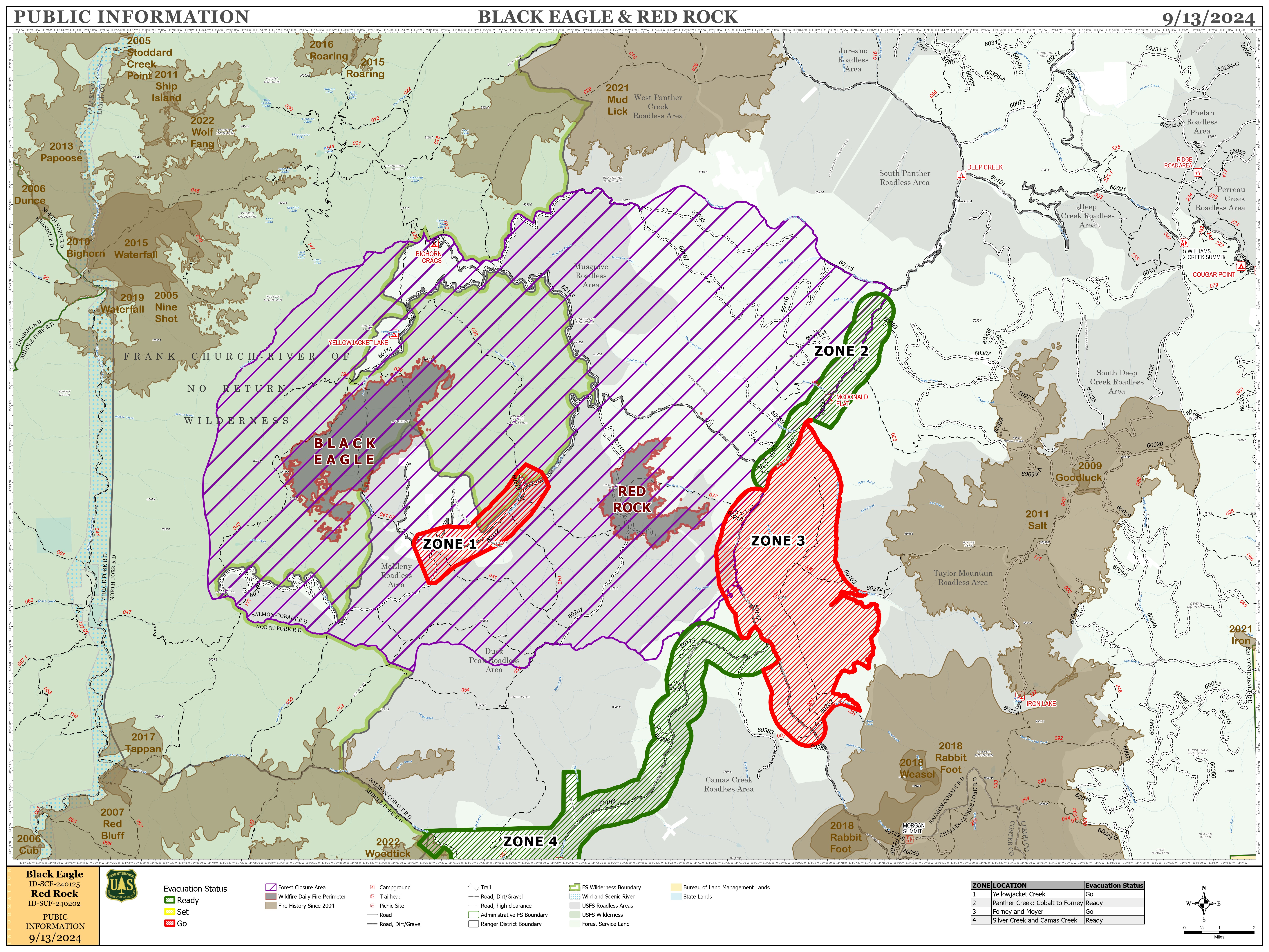
Additional resources have been ordered to assist in the management and containment of both Red Rock and Black Eagle fires, as firefighting forces attempt to use yesterday’s favorable weather conditions to make progress on fire containment.
Red Rock:
Fire acreage remains at 2570 acres with 0% containment. Yesterday, crews looked for opportunities to directly and indirectly engage the fire along its perimeter. Today, crews plan to construct a handline from Road 60110 North and East along the fire’s edge. Heavy equipment will used to improve access and expand fire control features along Road 60214, as well as on Road 60210 going west from roadway 60055.
Incident personnel continued structure protection activities along the Panther Creek Corridor up to the Ranger Station, and will extend those efforts north of Moyer.
Black Eagle:
Fire acreage remains at 5914 acres with 0% containment. On the north side of the fire, resources continue structure protection activities, implementing protective measures - sprinklers, hose, and pumps - at Yellowjacket and Bighorn Crags campsites, as well as Black Eagle Mine. Along the western boundary, resources continue to monitor conditions and look for opportunities to engage the fire.
Weather and Fire Behavior:
Yesterday a wetting rain blanketed the fire footprint, with snow seen in higher elevations. Today we can expect drier conditions, with temperatures in the 50’s over the fire area and relative humidity around 30%. Winds are expected at 5-10 mph out of the west, with gusts up to 20 mph along ridgetops.
Yesterday’s precipitation and nearly 20 hours of high humidity allowed much of the fuel load to absorb moisture and suppressed fire activity. Heavy dead and downed fuel are likely to retained heat despite the precipitation, and may continue to produce smoke. As the weather warms over the coming days, grasses and other small fuels quick to shed yesterday’s moisture will be the most likely areas of potential fire spread.
FOREST CLOSURE:
NFS lands, roads and trails on the Salmon‐Cobalt, and North Fork Ranger Districts of the Salmon‐Challis National Forest within the area bounded by the following:
Beginning at the intersection of Blackbird creek with Panther Creek, following Blackbird creek to Blackbird mountain, then following FS Road 33 to the Frank Church River of No Return Wilderness boundary, and following the boundary to the Golden Trout Lake Trailhead, including the Big Horn Crags Campground and crossing over into the Frank Church River of No Return Wilderness and onto the ridge to the west of Wilson Creek, then going south to Middle Fork Peak. From Middle Fork Peak to the Frank Church River of No Return Wilderness Boundary to trail 053 then running along Little Jacket Creek to Trail 051, then following Trail 051 to Birdseye Creek to Forest Road 245 at its intersection with Panther Creek Road 55, then following the western side of Panther Creek Road until it reaches Blackbird Creek.
- Additionally, the McDonald Creek Campground and all associated roads are closed.
For the latest information on area closures, please contact the North Fork Ranger District at (208) 865-2700.Details on the Black Eagle Fire can also be found on InciWeb: https://inciweb.wildfire.gov/incident-information/idscf-black-eagle-fire.
The forest is asking visitors to be aware of the fire danger for the Salmon-Challis National Forest. Ensure your campfire is dead out. If it is too hot to touch, it is too hot to leave! One Less Spark Means One Less Wildfire. Since June 1, Forest employees have found and extinguished at least 13 abandoned campfires.
EVACUATIONS:
Lemhi County: Evacuation order and warnings remain in effect. For more information, please go to: https://www.lemhicountyidaho.org/site-home/news/black-eagle-and-red-rock-fire-update
SMOKE REPORT:
For more information about drift and air quality, go to AirNow.gov https://outlooks.airfire.org/outlook/d60d6285.
Visit our website at: www.fs.usda.gov/scnf/, ‘Like Us’ on Facebook @salmonchallisnf, and ‘Follow Us’ on X @salmonchallisnf.
####
Map showing the fires in the forest
Miners Complex Daily Update 09 13 2024
Related Incident: Miners Complex Fires
Publication Type: Announcement
11:00 AM, September 13, 2024
Estimated size: 1,098 acres
Start Date/Time: July 17, 2024
Area of Origin: 21 air miles east of Darrington WA
Cause: Lightning
Fuels/Topography: timber, rugged terrain
Structures Damaged: None, there are no homes threatened at this time.
Evacuations: None
The Miners Complex consists of eight wildfires caused by lightning strikes in the Mt. Baker-Snoqualmie National Forest. The fires included in the complex are Miners Fire, Vista Ridge Fire, Dolly Creek Fire, Sulphur Three Fire, Sulphur Four Fire, Sulphur Thirty-Four Fire, Plummer, and Middle Ridge Fire.
Update: On Wednesday and Thursday there was little to no fire growth due to high relative humidities, cool temperatures, cloud covers and little winds. Over the weekend it is anticipated that fire behavior will continue to be moderated by cool temperatures and potential rains. Firefighter crews continue patrols of the Miners Complex along with accompanying rehab work.
Weather: Weak upper level ridge moving east this morning. Upper level trough approaching the area this afternoon will move over the area tonight and remain into Sunday. Friday will be mostly cloudy with rain showers likely in the afternoon. The high temperature will be around 61°F, with light winds becoming west 5-6mph in the afternoon. On Saturday, it will be mostly cloudy with rain showers likely in the morning and afternoon. High temperatures will be around 61°F, with light winds becoming west 5mph in the afternoon.
Smoke: For more information on smoke and air quality please visit: https://wasmoke.blogspot.com/
Closures: The following is a summary of the areas closed due to the fires in the Miners Complex: Pacific Crest National Scenic Trail #2000.2 from Mica Lake to Suiattle Pass, Suiattle River Trail #784, Miners Ridge Trail #785, Buck Creek Pass Trail #789, Miners Cabin Trail #795, Grassy Point Trail #788, Sulphur Mountain Trail #794, Sulphur Creek Trail #793, Sulphur Creek Campground, Sulphur Creek Trailhead, and the Downey Creek trailhead. Suiattle River Road, closure beginning at Downey Creek trailhead. The full Closure Orders visit: https://www.fs.usda.gov/mbs Forest Restrictions: The Mt. Baker-Snoqualmie has lifted the full campfire ban and forest-wide shooting restrictions, effective 8/28/2024. Additional details at: www.fs.usda.gov/mbs
###
Pincer Two Fire Daily Update 09 13 2024
Related Incident: Pincer Two Fire
Publication Type: Announcement
11:00 AM, September 13, 2024
Estimated size: 211 acres
Start Date/Time: July 17, 2024
Area of Origin: Johannesburg Mountain. 1 Mile East of Mineral Park C.G.
Cause: Lightning
Fuels/Topography: Timber, rugged terrain
Structures Damaged: None, there are no homes threatened at this time.
Evacuations: None
Closures: Cascade River Road at and including Marble Creek Campground, Mineral Park Campground, and all tributary roads, trailheads, and trails are all closed. The public is not to enter the area for public and firefighter safety.
Full closure orders available at: https://www.fs.usda.gov/mbs
Update: On Wednesday and Thursday, the fire area received light rain. The fire continues to burn at 3,500 feet; however, fire activity continues to be moderated by high relative humidities, cool temperatures, and cloud covers. Firefighters have removed structure protection wrap from the values at risk as the fire no longer poses danger to them and are actively working on securing the area in preparation for the Cascade River Road to reopen. Firefighters will continue to track any rolling debris and hot spots and monitor fire behavior.
Weather: Weak upper level ridge moving east this morning. Upper level trough approaching the area this afternoon will move over the area tonight and remain into Sunday. Friday will be mostly cloudy with rain showers likely in the afternoon. The high temperature will be around 61°F, with light winds becoming west 5-6mph in the afternoon. On Saturday, it will be mostly cloudy with rain showers likely in the morning and afternoon. High temperatures will be around 61°F, with light winds becoming west 5mph in the afternoon.
Smoke: For more information on smoke and air quality please visit: https://wasmoke.blogspot.com/
Air Space Restrictions: There are no air space restrictions at this time.
Forest Restrictions: The Mt. Baker-Snoqualmie has lifted the full campfire ban and forest-wide shooting restrictions, effective 8/28/2024. Additional details at: www.fs.usda.gov/mbs
###