
Daily Update for the Chimney Fire 09 13 2024
Related Incident: Chimney Fire
Publication Type: News
Firefighting crews take advantage of the rain
Daily Update – Friday September 13, 2024
Acres: 6,490
Start Date: 9/2/2024
Location: 9 miles northwest of Fairfield, ID
Personnel: 453
Containment: 10%
Fuels: Timber, brush, grass, understory
Highlights: Due to favorable weather patterns conducive to low fire activity, minimal progression of the fire was observed yesterday. A community meeting was held yesterday in Fairfield at the Camas County Senior and Community Center with a total of 30 community members in attendance.
Operations: Despite challenging weather and road conditions, firefighters were able to make significant progress on securing fire lines and scouting for contingency lines. Yesterday crews made progress on the southern edge of the fire while continuing mop-up operations. Firefighters scouted for potential access on the eastern and western flanks for future containment options. Additional resources remain available for any initial attack needs. No moisture is expected tomorrow, with very minimal fire behavior anticipated.
Weather: Afternoon highs today will return to seasonal normal of 58 to 67 under sunny skies. Humidity is expected to stay above 30 percent. Afternoon wind will be moderate from the southwest gusting into the 20 to 25 mph range.
Smoke: Smoke may be visible from the Fairfield area, with much improved air quality predicted today. An interactive smoke map located at https://fire.airnow.gov/ allows you to zoom into your area to see the latest conditions.
Closures: The Sawtooth National Forest has issued an emergency temporary closure of trails and trail segments for the Chimney Fire. The purpose of the closure order is for the protection of firefighters and public during wildfire suppression activities occurring in and around the trails. The full closure order (No. 0414-05-065) and map are available on the Sawtooth National Forest website at https://www.fs.usda.gov/alerts/sawtooth/alerts-notices.
Safety: The health and safety of firefighters and the public are always the first priority. A temporary flight restriction (TFR) is in place over the area, which includes uncrewed aircraft or drones. Flying drones near wildfires is dangerous for pilots and firefighters and can bring wildfire suppression efforts to a halt. Know before you fly. If you fly, we can’t. More information can be found at: https://uas.nifc.gov/.
More Information: https://inciweb.wildfire.gov/incident-information/ideix-chimney-fire /
208-246-8292 / https://www.facebook.com/sawtoothnationalforest / 2024.chimney@firenet.gov / https://www.facebook.com/IdahoDepartmentofLands/
Siphon Fire Evening Update 09 12 2024
Related Incident: Siphon Fire
Publication Type: News
Fire officials now estimate the #SiphonFire at approximately 12,000 acres with 0% containment. The cause remains under investigation. Due to the rugged terrain, ground resources cannot safely access the majority of the fire, but crews were able to conduct defensible firing operations on the northwest flank of the fire. Large air tankers were utilized around the north and northeast to slow the fire's growth. High winds contributed to the growth and calmer winds are predicted for tomorrow which will aid firefighting efforts.
SR 88 (Apache Trail) is closed past Lost Dutchman State Park. Tortilla Flat, Canyon Lake Marina, and Lost Dutchman State Park are all closed. Resources assigned include one Type 2 initial attack crew, one suppression crew and ten engines, along with a Type 1 helicopter. Resources on order include 2 scoopers and a Type 1 helicopter.
Fossil Complex Evening Update 09 12 2024
Related Incident: Fossil Complex
Publication Type: News
Firefighters continue progress on Service Fire
SPRAY, Ore. – With the cooler temperatures and higher humidity, fire activity was subdued, allowing firefighters to establish direct lines on the Spencer fire. Cooler weather and recent rain allowed for firefighters to work right next to the burning edge of the fire to minimize acres burned. From the west along the north side to the east point of the fire, direct line is already constructed and being strengthened. The southwest to south point along ORE 19 is progressing with chipping operations to remove excess debris and ODOT plans on opening the highway early Friday morning. Check for updates on ODOTs TripCheck - https://tripcheck.com/
The eastern part of the fire, towards Alder Creek Road, has a lot of work remaining to build and reinforce direct lines. Difficult terrain and extreme terrain on that part of the fire will require extra effort to build direct line. Matt Howard, ODF Incident Commander for ODF IMT 2 stated “There is a lot of edge and that is what it looks like when you utilize direct attack”.
The community meeting in Spray was attended by a small group of community members that heard updates from ODF Operations, the Incident Meteorologist, Dustin Gustaveson John Day Unit Forester, Jeremiah Holmes Fire Defense Board Chief, and Matt Howard Incident Commander.
Videos: Due to an issue with the Fossil Complex Facebook page, recordings of the meeting and Daily Operations Updates will be available at: https://www.youtube.com/@FossilComplex
The Wheeler County Sheriff’s Office continually evaluates evacuation levels. Please check their Facebook page for the latest information. https://www.facebook.com/WheelerCountySheriffsOffice/
The Two Cabin, Holmes, Kinzua and Canyon Fires are all in patrol status.
Flying unauthorized drones is hazardous to aircraft and will ground critical aerial operations.
FIRE AT A GLANCE
Fossil Complex
Total Size: 24,059 acres
Two Cabin-253 acres
Canyon-190 acres
Kinzua-96 acres
Holmes-15 acres
Service- 23,505
Containment: 3%
Cause: Lightning
Current Cost: $12 M
All Resources
Hand Crews: 40
Engines: 58
Water Tender: 16
Dozers: 20
Skidders: 7
Skidgen: 3
Excavator: 2
Masticator: 2
Feller Buncher: 4
Total Resources: 1,255
Aerial Resources
Type 1: 3
Type 2: 6
Type 3: 4
Evacuations:
Level 1: 21 addresses
Level 2: 85 addresses
Level 3: 156 addresses
https://www.facebook.com/WheelerCountySheriffsOffice/
ODF Incident Commander:
Matt Howard
Incident Management Team 2
Bridge Fire Evening Update09 12 2024
Related Incident: Bridge Fire
Publication Type: News
Unified Command: CIIMT5, Los Angeles County Fire, Los Angeles County Sheriff, San Bernardino County Fire, San Bernardino County Sheriff, CAL FIRE – San Bernardino/Inyo/Mono Unit
Incident Website:
inciweb.wildfire.gov/incident-information/caanf-bridge-fire
Fire Information: (626) 662-0120
Media Line: (626) 470-1395
Hours: 8:00 a.m. to 8:00 p.m.
Email: 2024.Bridge@firenet.gov
Fire Size: 51,580 acres
Percent Contained: 0%
Personnel: 2,104
Cause: Under investigation
Start Date: Sunday, September 8, 2024, at 2:12 p.m.
Location: Sheep Mountain Wilderness, Angeles National Forest
CURRENT SITUATION: Today, the Bridge Fire saw minimal growth across the entire fire perimeter due to decreased wind speeds and higher relative humidity. Water and retardant-dropping aircraft worked throughout the day, cooling hotspots with water and painting the ridge lines with fire retardant on the northwest side of the fire where heat was detected. Hand crews, dozers, and engines aggressively attacked the fire on the north flank to slow growth. Protecting structures within the affected communities remains the top priority for the fire crews. A smaller crew camp has been established on the fire's north side to shorten driving distances and response time.
On the east side, firefighters continue using Mt. Baldy Road to hold the fire, which is slowly backing from the west. Along the foothills, the southern flank of the fire has shown little movement, allowing firefighters to construct direct line along the fire’s edge, as well as crews strengthening containment lines by clearing and widening Sunset Peak Road with dozers and hand crews. Crews are monitoring and extinguishing hotspots in the fire’s perimeter up the southwest flank and are feeling confident they can hold containment lines. Air attack continues to monitor fire activity in the steep terrain along of the west flank.
Evacuation Orders:
- Hwy 138 south to Lone Pine Canyon and Highway 2 east to Lone Pine Canyon Road.
- Piñon Hills from Wrightwood north to Highway 18 and Beekley Road west to LA County.
- Lone Pine Canyon from the community of Wrightwood to Highway 138/Lone Pine Canyon Road south to the forest.
- Entire community of Wrightwood.
- East Fork communities of Camp Williams Resort (café, mobile home park, campground) and River Community (near the resort).
- Mt. Baldy Road, all residents north of the San Antonio Dam up to the Mt. Baldy Resort.
Evacuation Warnings:
- The area of Phelan from Hwy 138 east to Baldy Mesa Road and Phelan Road south to Sayle Road.
- San Antonio Heights and Upland from the foothills south to 23rd Street.
- Piñon Hills from Wrightwood north to Highway 138 and Lebec Road west to Los Angeles County.
“Know Your Zone” by visiting the Genasys Protect website or download the app. protect.genasys.com
Evacuation Centers:
- San Bernardino County Fairgrounds: 14800 Seventh Street, Victorville, CA 92392
- Jessie Turner Health and Fitness Community Center: 15556 Summit Ave, Fontana, CA 92336. Call (909) 854-5100
- Pomona Fairplex: 601 W McKinley Avenue Pomona, CA 91768 (Enter Gate 3, corner of McKinley and White)
- Animals:
- Devore Animal Shelter: 19777 Shelter Way, San Bernardino, CA 92407. Call (909) 386-9820, or after hours: (800) 472-5609
- Palmdale Animal Care Center (Small Animals): 38550 Sierra Hwy, Palmdale, CA 93550
- Lancaster Animal Care Center (Small Animals): 5210 W Ave I, Lancaster, CA 93536
- Antelope Valley Fairgrounds (Large Animals): 2551 W Avenue H, Lancaster, CA 93536. Call 562-706-8581 prior to arrival.
For more information on shelters, visit:
- www.redcross.org/get-help/disaster-relief-and-recovery-services/find-an-open-shelter.html
- https://lacounty.gov/emergency/
- If not already registered for emergency alerts, please register for them here:
CLOSURES:
- SR-138 from Lone Pine Canyon Road to Beekley Road
- SR-2 closed from Big Pines to SR-138
- San Gabriel Canyon and East Fork of the San Gabriel River
- Highway 39
- East Fork Road
- Glendora Ridge Road
- Glendora Mountain Road
- Mt. Baldy Road at Shinn Road intersection
WEATHER:
Conditions are shifting from hot, dry, and windy to colder trends with favorable humidity to also roll in. The high wind gusts predicted for last evening over the higher elevations never materialized.
For information on smoke impacts and an interactive map, visit fire.airnow.gov.
PUBLIC MEETING ON SATURDAY, SEPT. 14
The Incident Management Team is in the process of setting up a public meeting on Saturday, Sept. 14, starting at 6:00 p.m. The meeting will be live streamed on Facebook. The goal is to have an in-person location for the meeting, if possible, hopefully in/near the Phelan area.
Airport Fire Incident Update Evening 09 12 2024
Related Incident:
Publication Type: News
Location: Trabuco Canyon, CA
Personnel: 771
Start Date: 9/9/ 2024 01:00pm
Cause: Human
Size: 23,410 acres
Percent contained: 5%
Current Situation: The Airport Fire is currently at 23,410 acres with 5% of it contained. Evacuation levels have been downgraded in both Orange and Riverside Counties. Firefighters are actively working to reinforce containment lines southwest of the fire. A flare-up occured in an unburned pocket north of Trabuco Canyon, but it remains within the fire’s existing perimeter. Crews are conducting reconnaissance along the Santiago Peak fire lines, and heavy equipment operators are constructing a dozer line toward the Ortega highway. Aircraft, such as Air Tankers and helicopters were utilized throughout the afternoon during weather conditions that make up our critical burn period to assist ground crews in containing the Airport Fire. By crews strategically dropping retardant along the fire perimeter, these aircraft helped to mitigate and slow its spread to create a safer working environment for firefighters on the ground.
A complete copy of the evening update for September 12, 2024 may be found at the link below.
Red Rock and Black Eagle Fire Update 09 12 2024
Related Incident:
Publication Type: News
Fire Information: 208 389 4709
Hours: 8:00 AM to 8:00 PM
Email: 2024.redrock@firenet.gov
Website: https://www.fs.usda.gov/scnf/
As of 7:00 AM, California Interagency Incident Management Team 4 has taken command of the Red Rock and Black Eagle Fires.
Our primary mission on the Red Rock and Black Eagle Fires is to serve the public with dedication and compassion. With your safety and the safety of our firefighters in mind, we are committed to addressing the needs and concerns of your communities by managing and controlling the fires to keep your forests, and natural areas safe and enjoyable. Using safe and aggressive firefighting suppression methods our goal is to help you return to enjoying the outdoors.
Red Rock: Start date September 2, 2024, caused by lightening. Located approximately two miles east of Yellowjacket Guard Station on the Salmon-Cobalt Ranger District.
The fire has increased in size because of warmer weather, gusty winds, short-distance spotting, and difficult terrain. It now covers 2,570 acres and is still active. Poor visibility prevented the use of aerial resources today. Yesterday, crews worked on improving Panther Creek Road on both the east and west sides. Roads 210, 110, and 108 are being prepared as fire breaks. Today, crews will scout areas to build direct and indirect fire lines from Road 60110 south to Road 60201. They will also continue preparing Road 245 and Road 109 leading to the Ramhorn community.
Black Eagle: Start date August 5, caused by lightening. Located about 12 miles west of Forney on the North Fork Ranger District within the Frank Church River of No Return Wilderness.
The fire has now burned 5,914 acres and remains active. Poor visibility prevented the use of aerial resources today. Yesterday, crews set up multiple sprinkler systems at Yellowjacket Campground and Black Eagle Mine to protect those areas. Today, they are getting ready to install more sprinkler systems in the Crag Campground area.
WEATHER:
An upper-level weather system will stay over the fire area today, moving east and bringing more moisture to the region. This will lead to breezy westerly winds, with gusts up to 20 to 25 mph. It will also be much cooler on today. Over the next 48 hours, there’s a 60 to 70 percent chance of getting at least half an inch of rain in the fire area. If rain changes to snow, it’s expected to be light. By Friday, the weather system will move out, and it will become drier and warmer as the day goes on, with the winds becoming more stable.
FOREST CLOSURE:
NFS lands, roads and trails on the Salmon‐Cobalt, and North Fork Ranger Districts of the Salmon‐Challis National Forest within the area bounded by the following:
- Beginning at the intersection of Blackbird creek with Panther Creek, following Blackbird creek to Blackbird mountain, then following FS Road 33 to the Frank Church River of No Return Wilderness boundary, and following the boundary to the Golden Trout Lake Trailhead, including the Big Horn Crags Campground and crossing over into the Frank Church River of No Return Wilderness and onto the ridge to the west of Wilson Creek, then going south to Middle Fork Peak. From Middle Fork Peak to the Frank Church River of No Return Wilderness Boundary to trail 053 then running along Little Jacket Creek to Trail 051, then following Trail 051 to Birdseye Creek to Forest Road 245 at its intersection with Panther Creek Road 55, then following the western side of Panther Creek Road until it reaches Blackbird Creek.
- Additionally, the McDonald Creek Campground and all associated roads are closed.
For the latest information on area closures, please contact the North Fork Ranger District at (208) 865-2700.Details on the Black Eagle Fire can also be found on InciWeb: https://inciweb.wildfire.gov/incident-information/idscf-black-eagle-fire.
The forest is asking visitors to be aware of the fire danger for the Salmon-Challis National Forest. Ensure your campfire is dead out. If it is too hot to touch, it is too hot to leave! One Less Spark Means One Less Wildfire. Since June 1, Forest employees have found and extinguished at least 13 abandoned campfires.
EVACUATIONS:
Lemhi County: Evacuation order and warnings remain in effect. For more information, please go to: https://www.lemhicountyidaho.org/site-home/news/black-eagle-and-red-rock-fire-update
SMOKE REPORT:
For more information about drift and air quality, go to AirNow.gov https://outlooks.airfire.org/outlook/d60d6285.
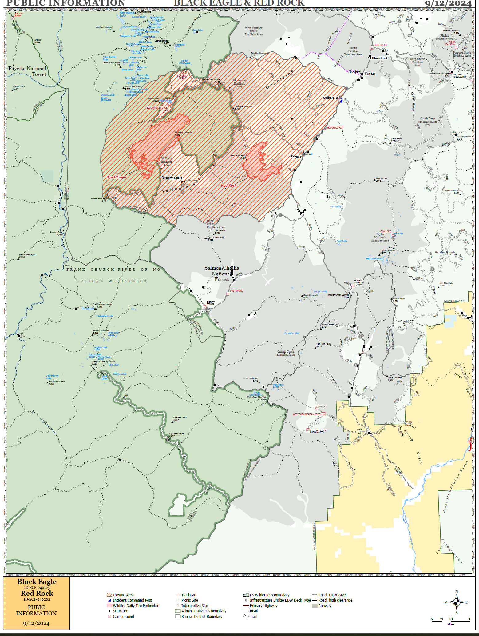
PIO map of the fires
Orange County Evacuation and Road Closure Change 09 12 2024
Related Incident:
Publication Type: Announcement
The complete evacuation order and road closure update for Orange County can be found with the link at the bottom of this page.
UPDATE: Mandatory Evacuation Orders for the Robinson Ranch community have been downgraded to Voluntary Evacuation Warnings with soft road closures in place at Plano Trabuco Road at Joshua Drive and Plano Trabuco Road at Robinson Ranch Road. The area is now open to RESIDENTS ONLY. Proof of residency will be required to enter the community.
We encourage residents to remain vigilant and be prepared to evacuate if fire conditions change, which can happen rapidly.
Hard road closures remain at:
- Trabuco Canyon Road and Trabuco Creek Road
- El Toro Road and Live Oak Canyon Road
- Ortega Highway at Nichols Institute
- Ortega Highway at Rancho Carrillo
Mandatory Evacuation orders remain in place for several areas along Ortega Highway, including Caspers Park, San Juan Springs and Blue Jay campground. Voluntary Evacuation Warnings remain in place for several areas in Rancho Santa Margarita and Trabuco Canyon. For detailed and updated evacuation information and resources, please visit ocsheriff.gov/airportfire.
Forest Closures Updated across Deschutes National Forest 09 12 2024
Related Incident: Bachelor Complex FiresFlat Top and Firestone Fires
Publication Type: Closures
Deschutes National Forest has updated and enlarged two temporary emergency fire closure areas on the Bend-Fort Rock Ranger District due to the Bachelor Complex, Flat Top Fire and Firestone Fire. The Bachelor Complex includes Little Lava Fire and Backside Fire as well as 30+ smaller fires within the area around Mt. Bachelor.
All National Forest System Roads found within the area closure are closed. Cascade Lakes Highway (NFSR 46) and NFSR 42 will remain open for public use.
The full closure descriptions and map products for temporary emergency closures on the Deschutes National Forest are online at https://www.fs.usda.gov/alerts/deschutes/alerts-notices.
Pedro Mine Fire Update 09 12 2024
Related Incident: Pedro Mine
Publication Type: News
Incident Commander: Chris Hericks
Location: Southwest of Branham Lakes Campground
Start Date: 09/04/2024
Cause: Lightning
Size: estimated at 152 acres
Resources on Site: 2 Initial Attack Modules
Total Personnel: 8
The Pedro Mine Fire, located nine miles east of Sheridan in the Mill Creek area, is burning in steep, rocky terrain with little to no access for firefighters. The area contains a large concentration of standing dead trees (“snags”) that pose challenges to ensuring firefighter safety and in responding to potential medical emergencies, jeopardizing the well-being of firefighters and other responders.
Fire managers from the Forest, working in collaboration with local Madison County officials have identified and prioritized critical values at risk in the fire area. Firefighting efforts will focus available resources on the protection of structures on private inholdings, active mining claims, and Branham Lakes Campground. All these values are approximately .1-.6 miles from the fire.
There are several factors involved in making wildfire management decisions. These factors include, firefighter safety, resource availability and threats to public safety and property. As well as, terrain, fire behavior, fire season outlook and modeling, and past prescribed fire units and vegetation management projects in the area. Fire managers are strategic in their approach and continually reassess conditions and alter management strategies to protect critical values.
CURRENT STATUS/PLANNED ACTIONS:
Resources had an abbreviated shift on the fire today. Plentiful snow and rain was received throughout the morning. 1” of moisture was measured in the rain gauge as of 02:00 PM. The fire experienced no growth or activity because of the moisture and cold temperatures. The barricade remains in place at the intersection of Mill Creek Road (FS RD 111) and the Middle Fork Mill Creek Road (FS RD 7313) to limit public access into the fire area and Branham Lakes Campground. This will remain until crews can make sure snags are removed from the campground and where firing operations occurred along Mill Creek Road. This is anticipated to take through the weekend.
The fire will be un-staffed tomorrow to let conditions dry out. Crews will be doing other project work on the district and rehabbing gear and equipment. As significant moisture was received this will be the last evening update for the Pedro Mine Fire.
WEATHER AND FIRE BEHAVIOR:
The fire received 1” of moisture as of 02:00 PM today. Forecasts are for an additional 0.5-1.0” tonight. As most of the fire area is above 8,500’ measurable snow could cover the entire fire by tomorrow morning. If this forecast plays out it will be considered at least a season-moderating event and may be a season ending event for the fire area.
CLOSURES AND RESTRICTIONS:
The Forest is in Stage 1 Fire Restrictions. Campfires are allowed only in a permanent metal fire grate/ring provided by the Forest Service in a designated, developed recreation site. Smoking is restricted to vehicles, in buildings, or in
an area clear of flammable materials. Devices with an on/off switch that use LPG fuels are allowed in an area clear
of flammable materials within 3 feet of the device.
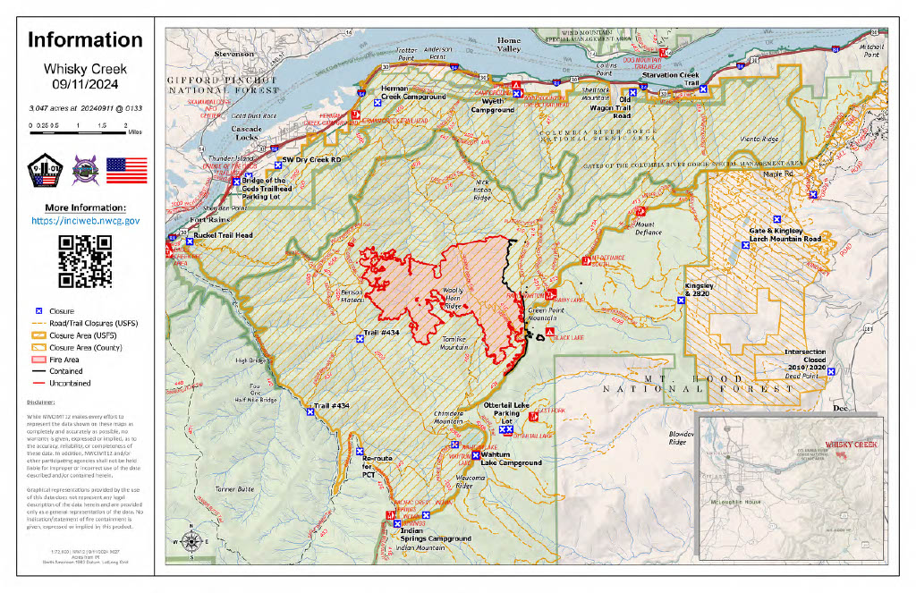
Actualizacin diaria del incendio Whisky Creek 09 12 2024
Related Incident: Whisky Creek Fire
Publication Type: News
Tamaño de Whisky Creek: 3,047 acres | Fecha de inicio: 20 de julio |Causa: De orígen humano |Contención 25%
Total de recursos: 165 | Equipos de obreros: 2 | Camiones de bomberos: 2 | Topadoras: 2 | Maquinarias pesadas: 2 | Helicópteros: 1
El incendio Whisky Creek se encuentra en un terreno escarpado y escabroso dentro del área de naturaleza Mark O. Hatfield en el Bosque Nacional Mt. Hood. Permanece dentro de las líneas de control a lo largo de los extremos sur y este. La huellas del incendio Eagle Creek continúan como barrera a lo largo de los extremos oeste y norte del incendio. Hubo lluvia desde el martes por la noche hasta el miércoles que ayudó a minimizar la intensidad del fuego ayer. Debido a que la lluvia que cayó fue menos de lo que se esperaba, las comunidades del valle de Hood River y el Columbia River Gorge aún verán humo ya que arden combustibles grandes.
Anoche, el Equipo de gestión de incidentes interagenciales de Central Cascades se hizo cargo del incendio Whisky Creek. Deseamos agradecer al Equipo 12 del Noroeste por el excelente trabajo que realizaron durante el tiempo que estuvieron asignados aquí. Los incendios Sandstone y Blister Creek serán gestionados por una organización local de Tipo 4.
Ayer, el incendio creció muy poco sin casi ninguna actividad. Las cuadrillas continuarán llevando a cabo reparaciones ligeras de extinción para ayudar a prevenir la erosión. Los asesores de recursos continúan trabajando con las cuadrillas y las maquinarias pesadas mientras que realizan la reparación para minimizar los impactos a los recursos naturales y culturales. Los bomberos continuarán patrullando las partes accesibles del perímetro del incendio.
Clima: Ayer, el clima más fresco ayudó a minimizar la intensidad del incendio. Existe la posibilidad de que se desplace al área otro sistema meteorológico durante el fin de semana y se está pronósticando lluvia.
Para saber el pronóstico de humo y seguridad, consulte: oregonsmoke.org.
Cierres: Los cierres de áreas permanecerán en el Bosque Nacional Mt. Hood, el Área Escénica Nacional Columbia River Gorge y el Condado de Hood River. Se establecen cierres para la seguridad del público y de los bomberos; La intrusión en un área de cierre puede interrumpir las actividades de extinción y reparación de incendios, poner en peligro vidas y propiedades, y puede resultar en multas. La información de cierre se encuentra en: https://linktr.ee/whisky_creek.2024.
Seguridad: El público juega un papel importante en la prevención del próximo incendio forestal; tenga cuidado con cualquier posible fuente de incendio. Para obtener consejos de prevención, consulte: https://keeporegongreen.org. La TFR sigue vigente para el incendio Whisky Creek: https://tinyurl.com/2s49yrj4. Las restricciones contra incendios están vigentes dentro del Bosque Nacional Mt. Hood:https://www.fs.usda.gov/main/mthood/fire.