
Middle Fork Complex Operations Video September 12 2024 09 12 2024
Related Incident:
Publication Type: Announcement
Middle Fork Complex Operations Video September 12, 2024
https://www.youtube.com/watch?v=YodZy_jRJPg
West Mountain Fires Daily Update 09 12 2024
Related Incident: Dollar Fire
Publication Type: News
Snag: 11 miles E of Cascade, 33,244 acres, 15% contained, https://tinyurl.com/4k9dk3mu
Dollar: 18 NE of Cascade, 4,359 acres, 8% contained, https://tinyurl.com/bef6r3tz
Goat: 11 miles SE of Cascade, 25,648 acres, 0% contained, https://tinyurl.com/2h4a3dvr
Cause: Lightning (All Fires)
Personnel: 926
Special Notes:
As of 6am today, the Boulder Fire is part of the Lava Fire, being managed by the Southern Area Red Complex Incident Management Team. Information for this fire can now be acquired at:
- Lava Fire InciWeb page: inciweb.wildfire.gov/incident-information/idbof-lava-fire
- Lava Fire Facebook page: https://www.facebook.com/profile.php?id=61565511999356
- Lava Fire Information phone line: 208-780-5003
- Lave Fire email: 2024.Lava@firenet.gov
EVACUATIONS: Please check Valley County Sheriff’s Office Facebook or call dispatch at 208-382-5160.
Weather and Fire Behavior:
The fire area received .25” – .75” of rain yesterday and overnight, and more scattered showers are expected today. Temperatures will be much lower, in the 50s and 60s in lower elevations and higher elevations 40s to upper 30s. Winds will come from the W to NW with gusts up to 15-18 on the ridgetops. Looking ahead, the weekend may bring a brief warmup with rain returning Monday to Tuesday with .5” to 1” possible. Moisture has currently reduced fire behavior to mostly creeping and smoldering with some possible isolated torching. Limited to no growth is expected today.
Dollar Fire:
- The Dollar Fire is currently unstaffed and remains in “monitor” status.
Snag Fire:
- Crews continue mopping up and securing the Warm Lake Rd. Crews are working to manage some rock rollout on this road due to the recent precipitation.
- On the east side, firefighters installed sprinkler systems and hose lays near the Fish Hatchery and structures in that area. The fire has had very little movement on the east side.
- Masticators are removing fuels along Bear Creek, Lodgepole Creek, and Rice Creek.
- On the south side of the Snag Fire, firefighters had previously placed sprinklers near bridges on the 409 Road, and they continue checking this equipment and monitoring this area.
- Patrol continues on the west side of the Snag Fire.
Goat Fire:
- A structure protection group is in the area of Horsethief Reservoir assessing needs around structures and will begin structure preparation and plumb the area today.
- Yesterday, an approximate ¼ acre spot fire developed between the 417H1 and the 409, but with the recent moisture, it is not moving or causing concern.
- Crews are completing prep on the 409 Road.
- Firefighters continue improving the Horsethief road and will likely complete their work on this road today.
Davis Fire Update 09 12 2024
Related Incident: Davis Fire
Publication Type: News
Southwest Area Incident Management Team Update for Wednesday, September 12, 2024
Acres: 5,824 acres
Start Date: 09/07/2024
Location: Washoe Valley, Nevada
Personnel: 631
Containment: 37%
Fuels: Timber
Resources: 9 Crews | 14 Helicopters | 71 Engines | 4 Water Tenders | 3 Dozers
Highlights: Through the strong work and dedicated efforts of ground crews daily and nightly, the fire experienced minimal growth yesterday. This progress was achieved despite challenging weather conditions, the remote and rugged terrain in the western area, and the complexities of the Wildland Urban Interface (WUI) environment. Yesterday, aircraft operations were suspended after 9:00 AM as winds reached 75 MPH on the ridgetops, with gusts of up to 54 MPH in the valleys. Through diligent work of firefighters extinguishing hot spots near the perimeter and continuously patrolling unburned areas looking for any new spots the fire stayed within its footprint. The southern perimeter of the fire, from Highway 580 in Washoe Valley to the upper edge near Mount Rose, is largely secured with fire hose and handline. Dozer lines and hose lays have been strategically placed to protect all communities located south-southwest of Highway 431 near Galena Forest and Callahan. Water tenders and portable water tanks set up in place to make water usage readily available.
Fire Activity: Low to moderate fire behavior is expected today. Firefighters will continue mop-up operations, though isolated pockets of smoke will still be visible. Mop-up refers to the process of extinguishing or eliminating any remaining hot spots, embers, or smoldering debris after the main fire. Mop-up activities include dousing burning material with water, breaking apart hot debris, turning over ashes, cutting down or clearing any trees or vegetation that may still be smoldering, and making sure the perimeter is secure. Crews will also be removing any hazard trees that have burned and are at risk of falling across any fire lines or roads.
Weather: Cooler temperatures and a substantial decrease in winds are forecast for the next few days. Temperature will be around 70 degrees. Relative humidity levels are expected to reach around 60% today, a significant increase from the 12% recorded yesterday. This dramatic shift will positively support containment efforts.
Evacuations: We urge everyone to remain vigilant and stay clear of evacuation zones. Stay informed by relying on official fire information sources. For updates on evacuation statuses please visit: https://perimetermap.com
Willamette Complex North Daily Update 09 12 2024
Related Incident: North Willamette Complex
Publication Type: News
Willamette Complex North Update
Boulder Creek, Ore, Linton Creek, Pyramid, 374, and Roundtop fires
Date: Thursday, September 12, 2024
Willamette Complex North Facebook Page: https://www.facebook.com/profile.php?id=61565845313387
Email: 2024.WillametteComplex.North@firenet.gov Information line: 541-208-1262 Hours: 8 a.m. to 8 p.m.
Overview: Rain of up to an inch fell over the complex in the last 24 hours. This decreased fire behavior with minimal fire activity overnight. Limited spread is expected today, with some smoke visible. The Boulder Creek Fire remains the top priority. A road closure continues for a section of OR 242, and a portion of OR 126 remains closed while conditions are evaluated. The Boulder Creek Fire reached OR 126 and crews continue to clear hazard trees. Today the rain will taper off with clouds, light winds, and highs in the mid-50s. Fire crews are using the day as an opportunity to make additional progress on containment lines.
Boulder Creek Fire Evacuation Notices
LEVEL 3 (GO NOW) EVACUATION NOTICE: Scott Creek Road
LEVEL 1 (BE READY) EVACUATION NOTICE: South of Highway 126 from milepost 53.5 east to Scott Creek Road and Horse Creek Road east of Foley Springs, Foley Springs, Forest Service Road #302, Belknap Springs Road South, Camp Yale Road, Yale Lane, North of Highway 126 East from the east end of Drury Lane to the end of North Belknap Springs Road
Linton Creek Fire Evacuation Notices
Level 3 (GO NOW) EVACUATION NOTICE: Pacific Crest Trail near Linton Meadow and near Husband Lake
Evacuation Notice Source: Visit www.LaneCountyOR.gov or use this link.
Boulder Creek: 501 acres, 0% contained
Located 5 miles east of McKenzie Bridge. Structure protection work has been underway. Crews are going direct on the fire where possible and safe.
Ore: 3461 acres, 44% contained
Located 7 miles northeast of Blue River. Crews continue to improve containment lines. Pockets of unburned fuel remain that could still pose minimal threat to containment lines.
Linton Creek: 1288 acres, 0% contained
Located in the Three Sisters Wilderness northeast of Eileen Lake. Rainy weather helped decrease fire behavior.
Pyramid Fire: 1,311 Acres, 98% contained
East of Middle Santiam Wilderness. Hauling out fuels to secure containment lines continues.
374: 47 acres, 0% contained
This fire is also in the Three Sisters Wilderness, northwest of Packsaddle Mountain. Smokejumpers are assigned to the fire and trails are being prepped as containment lines.
Roundtop: Near the 374 Fire and Little Roundtop Mountain. It was kept at a quarter acre and near full containment.
Road Closures: Due to the Boulder Fire, OR 126 is closed between mileposts 13 and 19.5 (intersection with OR 242). OR 242 remains closed to all traffic indefinitely between the intersection with OR 126 and the Dee Wright Observatory (mileposts 55 to 75), in the area of the Linton Creek Fire. Use an alternate route; do not divert onto forest roads to avoid closures. Check for updates at: https://tripcheck.com/
Willamette National Forest Area Closures: Due to increased fire activity in the McKenzie River Ranger District, the Linton Creek closure area was expanded to include Boulder Creek, 374, Roundtop, as well as other fires on the Middle Fork Ranger District including Young Grasshopper and Lowell Creek fires. Source: https://www.fs.usda.gov/detail/willamette/alerts-notices/?cid=fseprd552029.
###
Willamette Complex South Daily Update for Thursday September 12 2024 09 12 2024
Related Incident: Willamette Complex Fires - South
Publication Type: News
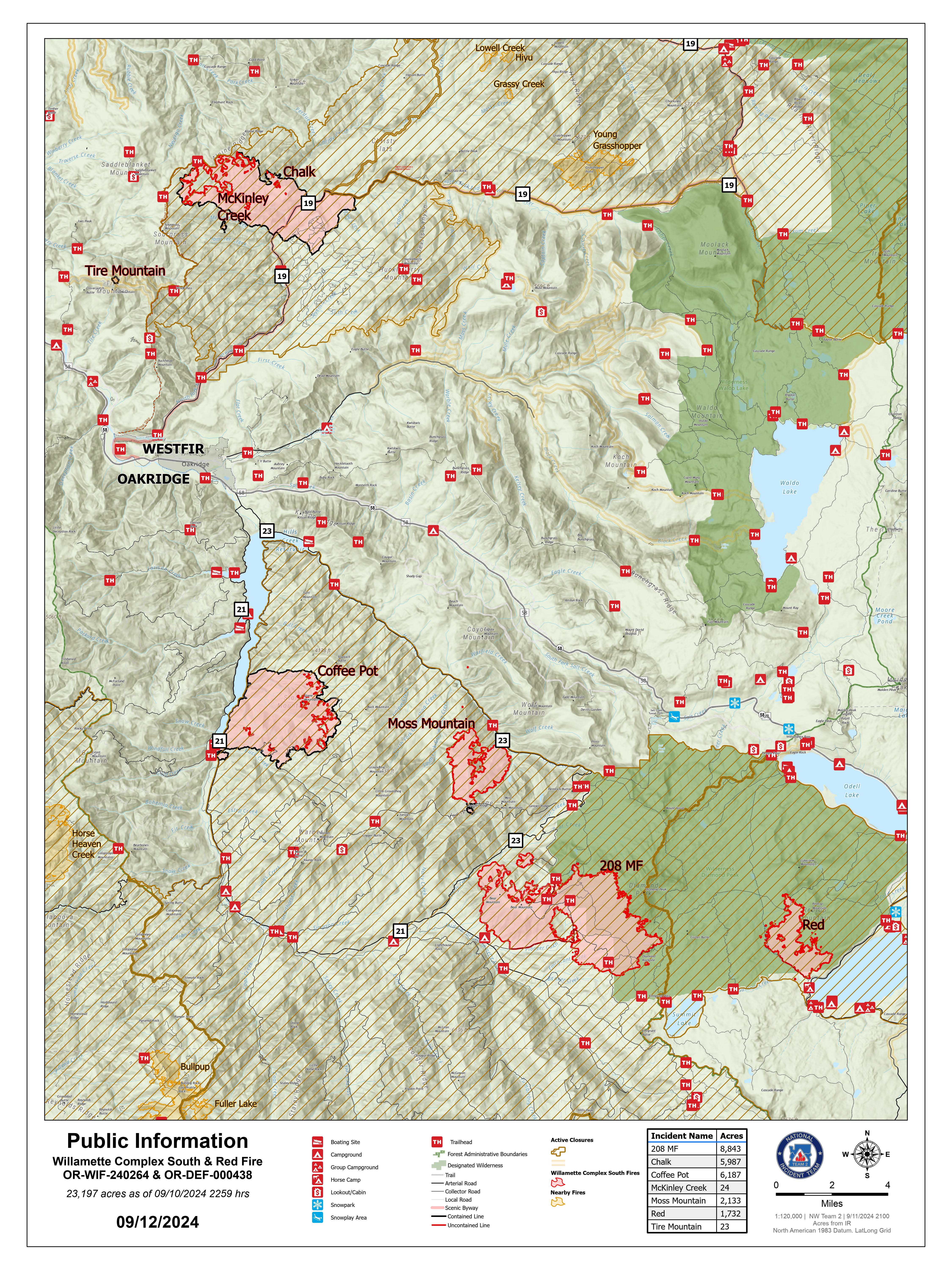
Willamette Complex South & Red Fire Update
Red, 208, Moss Mountain, Coffee Pot, Tire Mountain, McKinley Creek and Chalk Fires
Date: Thursday, September 12, 2024
Fire Causes: Lightning
Email: 2024.willamettecomplex@firenet.gov
Information Phone Line: 541-208-1742
Willamette Complex South: Total Personnel: 674 | Total Willamette Complex South Acres: 23,197
InciWeb: https://inciweb.wildfire.gov/incident-information/orwif-willamette-complex-fires-south
Facebook: https://www.facebook.com/WillametteComplexFires/
Red Fire: Total Personnel: 68 | Total Red Fire Acres: 1,732
InciWeb: https://inciweb.wildfire.gov/incident-information/ordef-red-fire
Facebook: https://www.facebook.com/2024RedFireOR/
Summary
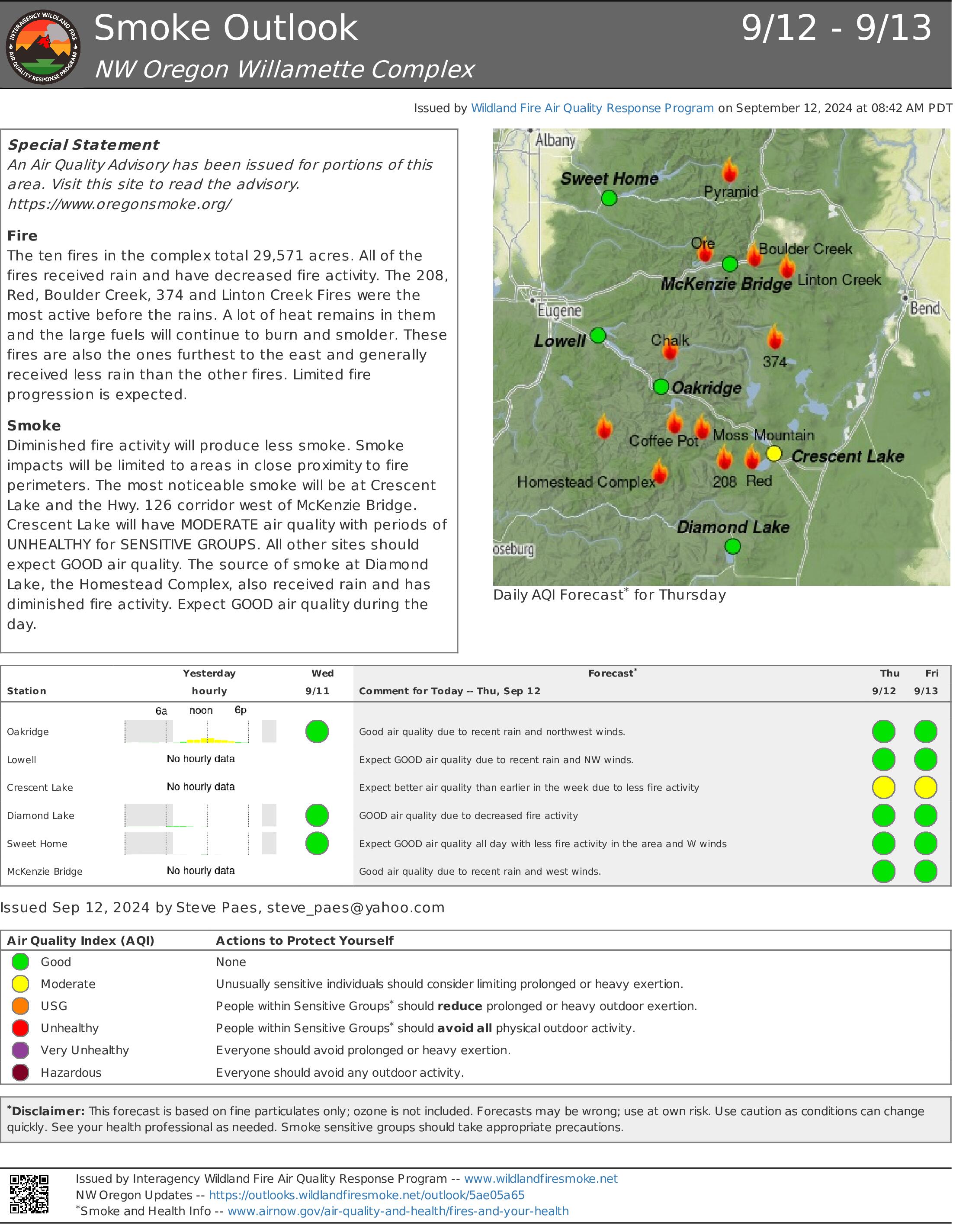
Yesterday’s passing weather system provided an opportunity to reevaluate fire behavior and determine operational needs. Fire managers continue to prioritize the minimization of acres burned. With fire behavior moderated by the rain, firefighter operations began shifting from line preparations to repair. However, some work will continue to connect existing segments of fireline. Rain also halted heavy equipment operations, including road repair, in areas where soils were saturated and posed a greater risk to resources than the fire conditions demanded. Where conditions allowed, slash and logs were removed from previously prepped roads.
Red Fire (1,732 acres, 0% containment)
Structure preparations were completed yesterday with the installation of several portable water holding tanks. All deployed structure protection equipment will continue to be checked and maintained in the event of unforeseen changes in fire behavior. Extensive rain halted firefighter operations on the reinforcement of indirect line in the area. The Whitefish Creek Trail was lined with 9,000 feet of hose. This hoselay serves as an indirect line while fire behavior and resource needs in this area are being reevaluated.
208 Fire (8,843 acres, 0% containment)
The fire remains north of Forest Service Road (FSR) 29 where burning operations occurred last Sunday. Fire growth is gradual in the direction of indirect line along FSR 23 to the northwest and FSR 21/2154 to the south. Indirect handline construction meant to protect private timber is complete from FSR 23 to FSR 423.
Moss Mountain Fire (2,133 acres, 8% containment)
Primary and contingency lines along FSR 23, 2120, 490, and 2309 are being patrolled. The focus remains on confinement of the fire's northward spread to minimize burned acreage. Work will proceed today on suppression where needed. Additionally, repair activities will continue as crews evaluate how the rain impacted fire activity.
Chalk Fire (5,987 acres, 86% containment)
Firefighters remain engaged in repair activities. Crews continue to improve indirect line by removing and chipping vegetation. Additionally, the firefighters will continue to patrol and monitor existing containment lines.
Weather and Fire Behavior
Yesterday, a low-pressure system brought consistent rainfall to the area. On average there was about a 0.50" of rain across the area. This moderated fire behavior by bringing moisture to previously dried fuels. Looking ahead, elevated relative humidity and persistent cloud cover and smoke are expected through early next week. This cooling trend will continue to reduce fire behavior to creeping and smoldering.
Closures, Fire Restrictions, and Evacuations
- For closure information, visit: https://tinyurl.com/RedFireClosues2024 & https://tinyurl.com/WillFireClosures2024.
- For fire restrictions, visit: https://tinyurl.com/DesFireRestrictions2024 & https://tinyurl.com/WillFireRestrictions2024.
- For current Temporary Flight Restrictions (TFR), visit: http://tfr.faa.gov.
- The Level 1 – BE READY to Evacuate notice remains in effect for the Red Fire. For more information or to sign up for alerts, visit: www.klamathcounty.org/300/emergency-management.
Bear Fire Daily Update 09 12 2024
Related Incident: Bear Fire, Tahoe National Forest
Publication Type: News
Location: South of Sierra Brooks off Bear Valley Rd., Tahoe National Forest
Personnel: 233
Start Date: 9/2/2024 @ 2:00 PM
Cause: Undetermined
Size: 3,323 acres
Percent contained: 83%
The Bear Fire has continued to remain in its footprint despite an increase in winds. Repair efforts are now fully underway.
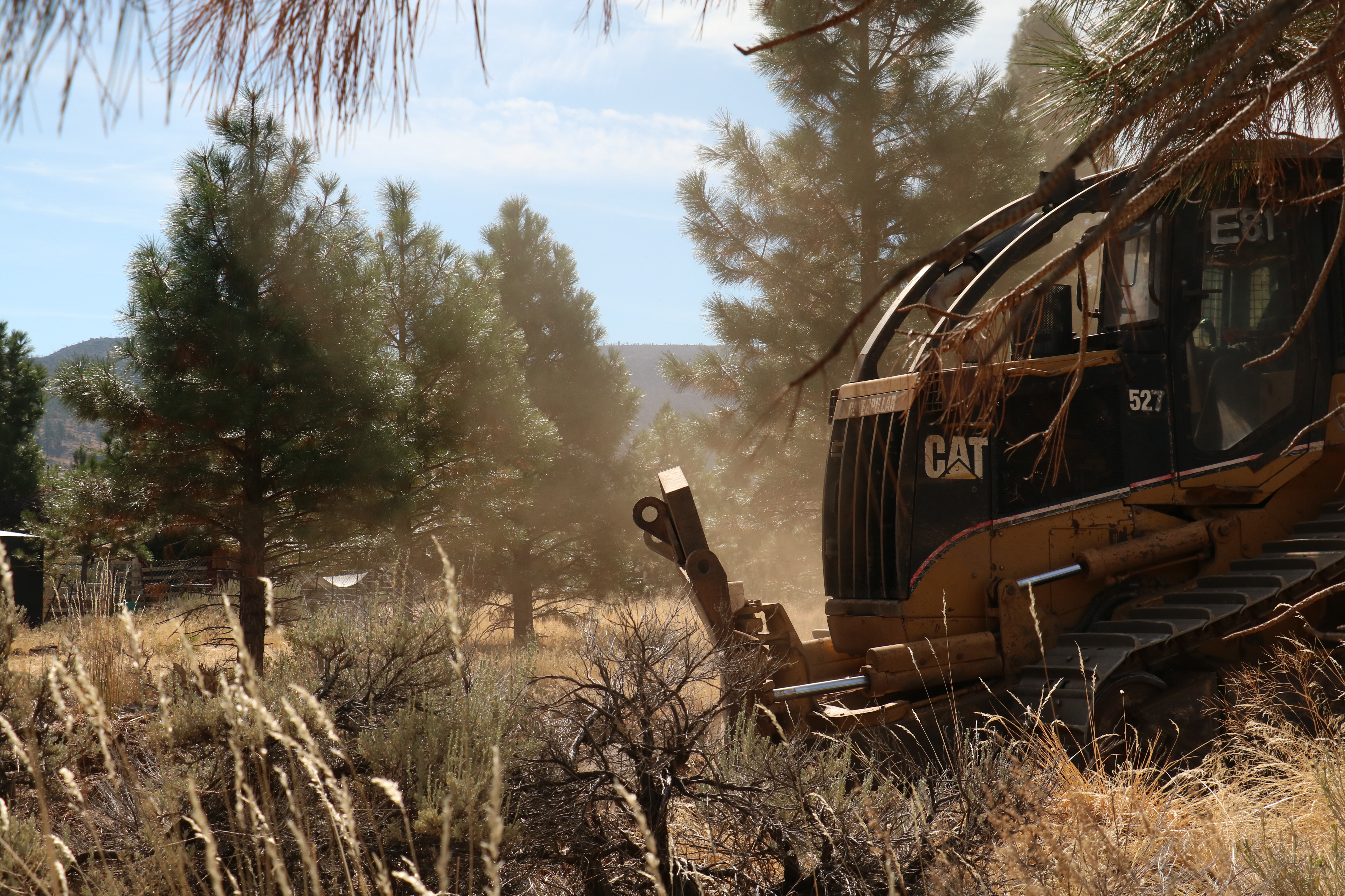
Patrol and repair operations are the focus, with crews continuing to build containment and mop up into the fire footprint to expand the buffer zone. Repair operations are taking place along the Badenough Ridge and in Badenough Canyon, where crews are working to improve road drainage. Other repair activities include mitigating long-term environmental impacts and facilitating the restoration of the affected landscape. Repair operations include chipping and road repair in areas damaged by suppression efforts.
The stronger winds that brought in Wednesday’s cold front are expected to die off, with breezes from the northwest. Temperatures are expected to be cooler throughout the day.
NV Energy will reenergize the power lines Friday morning beginning at 4:30 A.M. Residents can expect 30 minutes gaps in power as they work to restore lines.
Due to decreasing fire activity, Tahoe National Forest has updated the forest closure for the Bear Fire area reflecting a reduction in the closure area. The purpose of the closure order is to provide for public safety during wildland fire suppression efforts and to keep the general public at a safe distance from any fire activity.
WEATHER:
Cooler weather is expected on Thursday with high temperatures dipping around 10 degrees below seasonal averages after Wednesday’s cold frontal passage. Brisk north-northeast breezes around 5-10 mph will prevail this afternoon with highs in the upper 60s to near 70 and minimum humidities around 20-25%.
EVACUATIONS:
Sierra County: Evacuation order and warnings remain in effect. For an interactive map of evacuations, visit: https://protect.genasys.com/search.
FOREST CLOSURE:
An updated forest closure has been issued. For more information visit the Tahoe National Forest website at: https://www.fs.usda.gov/alerts/tahoe/alerts-notices.
Red Fire Daily Update for Thursday September 12 2024 09 12 2024
Related Incident: Red Fire
Publication Type: News
Willamette Complex South & Red Fire Update
Red, 208, Moss Mountain, Coffee Pot, Tire Mountain, McKinley Creek and Chalk Fires
Date: Thursday, September 12, 2024 Fire Causes: Lightning
Email: 2024.willamettecomplex@firenet.gov Information Phone Line: 541-208-1742
Willamette Complex South: Total Personnel: 674 | Total Willamette Complex South Acres: 23,197
InciWeb: https://inciweb.wildfire.gov/incident-information/orwif-willamette-complex-fires-south
Facebook: https://www.facebook.com/WillametteComplexFires/
Red Fire: Total Personnel: 68 | Total Red Fire Acres: 1,732
InciWeb: https://inciweb.wildfire.gov/incident-information/ordef-red-fire
Facebook: https://www.facebook.com/2024RedFireOR/
Summary
Yesterday’s passing weather system provided an opportunity to reevaluate fire behavior and determine operational needs. Fire managers continue to prioritize the minimization of acres burned. With fire behavior moderated by the rain, firefighter operations began shifting from line preparations to repair. However, some work will continue to connect existing segments of fireline. Rain also halted heavy equipment operations, including road repair, in areas where soils were saturated and posed a greater risk to resources than the fire conditions demanded. Where conditions allowed, slash and logs were removed from previously prepped roads.
Red Fire (1,732 acres, 0% containment)
Structure preparations were completed yesterday with the installation of several portable water holding tanks. All deployed structure protection equipment will continue to be checked and maintained in the event of unforeseen changes in fire behavior. Extensive rain halted firefighter operations on the reinforcement of indirect line in the area. The Whitefish Creek Trail was lined with 9,000 feet of hose. This hoselay serves as an indirect line while fire behavior and resource needs in this area are being reevaluated.
208 Fire (8,843 acres, 0% containment)
The fire remains north of Forest Service Road (FSR) 29 where burning operations occurred last Sunday. Fire growth is gradual in the direction of indirect line along FSR 23 to the northwest and FSR 21/2154 to the south. Indirect handline construction meant to protect private timber is complete from FSR 23 to FSR 423.
Moss Mountain Fire (2,133 acres, 8% containment)
Primary and contingency lines along FSR 23, 2120, 490, and 2309 are being patrolled. The focus remains on confinement of the fire's northward spread to minimize burned acreage. Work will proceed today on suppression where needed. Additionally, repair activities will continue as crews evaluate how the rain impacted fire activity.
Chalk Fire (5,987 acres, 86% containment)
Firefighters remain engaged in repair activities. Crews continue to improve indirect line by removing and chipping vegetation. Additionally, the firefighters will continue to patrol and monitor existing containment lines.
Weather and Fire Behavior
Yesterday, a low-pressure system brought consistent rainfall to the area. On average there was about a 0.50" of rain across the area. This moderated fire behavior by bringing moisture to previously dried fuels. Looking ahead, elevated relative humidity and persistent cloud cover and smoke are expected through early next week. This cooling trend will continue to reduce fire behavior to creeping and smoldering.
Closures, Fire Restrictions, and Evacuations
- For closure information, visit: https://tinyurl.com/RedFireClosues2024 & https://tinyurl.com/WillFireClosures2024.
- For fire restrictions, visit: https://tinyurl.com/DesFireRestrictions2024 & https://tinyurl.com/WillFireRestrictions2024.
- For current Temporary Flight Restrictions (TFR), visit: http://tfr.faa.gov.
- The Level 1 – BE READY to Evacuate notice remains in effect for the Red Fire. For more information or to sign up for alerts, visit: www.klamathcounty.org/300/emergency-management.
Devils Knob and Milepost 98 Fire Morning Update 09 12 2024
Related Incident:
Publication Type: News
Devil’s Knob and Milepost 98 Fire Morning Update for Thursday, September 12, 2024
KEY MESSAGES:
A public meeting was held last night in Tiller, Oregon where fire managers provided an operational briefing to 12 members of the local community. A recording of the meeting can be viewed on the Devil’s Knob and Milepost 98 Fires 2024 Facebook page.
Containment of both fires continues to increase due to firefighting efforts and the change in weather. Containment will progress as firefighters continue securing fireline and fire managers evaluate the threat to control lines surrounding the perimeter.
The Oregon Department of Forestry (ODF) Southwest Oregon District has decreased the fire danger level on ODF-protected lands in Jackson and Josephine counties to high. Current regulations are available on www.swofire.com.
CURRENT STATUS:
Devil’s Knob- Resources: 657, Crews: 19, Engines: 16, Water Tenders: 12
The northern flank and a large section of the western edge of the fire perimeter is in patrol status. This indicates the potential for reignition of the fire in these areas is minimal. The tactical firing operation along Forest Service Road 400 earlier in the week was successful in clearing out pockets of unburned fuel to make a clean line to mitigate further growth. Mop-up operations continue throughout this area. Active line construction continues on the south and southeast portions of the fire perimeter.
Milepost 98- Resources: 325, Crews: 13, Engines: 12, Water Tenders: 9
As containment increases, snagging operations continue in order to reduce aerial hazards and allow firefighters the ability to gain depth with mop-up along the fire perimeter more safely. A heli-spot was established within the fire perimeter where fuels have cooled to be utilized in support of incident personnel. All line is complete around the fire perimeter, which will allow crews to focus on bolstering containment efforts.
WEATHER / FIRE BEHAVIOR:
Temperatures will remain in the 60s today as relative humidity remains between 55-65%. Early showers within the fire area will assist in slowing the progression of the fire. A wetting rain accumulated over the fire area yesterday, and there is potential for similar conditions today.
SAFETY AND CLOSURES:
Umpqua National Forest remains in High Fire Danger, Public Use Restrictions Level 2, and Industrial Fire Precaution Level 2. For more information on fire restrictions, visit: https://www.fs.usda.gov/main/umpqua/fire. Closures on the Umpqua National Forest can be found at https://www.fs.usda.gov/alerts/umpqua/alerts-notices. These alerts show the official closure orders with listed roads and trailheads, as well as maps of the closed areas.
Middle Fork Complex Fire Update 09 12 2024
Related Incident:
Publication Type: News
Middle Fork Complex Fire Update
Thursday, September 12, 2024
Crews Assess Conditions After Rain and Lightning
The Middle Fork Complex is 61,159 acres, remaining at 30% completion. There are 592 personnel currently assigned to the complex, including 12 hand crews and 28 engines. Rain is likely this morning, with a chance of rain continuing into the evening. Temperatures are below normal for this time of year with a relative humidity remaining at or above 60%. This weather will reduce fire activity to smoldering and creeping along the forest floor with possible pockets of increased activity in areas with large dead and down vegetation.
After yesterday’s weather event, today’s focus is assessing safety conditions of the Bulldog and Nellie Fire areas to ensure any hazards are mitigated prior to reengaging in firefighting operations. Crews continue removing fuels to create defensible space around the Silver Creek Plunge and Boiling Springs areas. Heavy equipment and crews continue chipping along the 698 and 671 roads to further strengthen contingency lines.
Crews have completed a portion of burn out operations on Scott Mountain ridge and continue to assess mitigation efforts to help protect Scott Mountain lookout. The Nellie Fire perimeter along Highway 17 (Banks Lowman Road) continues to have little to no fire activity.
Firefighters continue to strengthen firelines on the Nellie Fire around the Deadwood Reservoir area. They are prepared to protect Whitehawk lookout if the fire progresses east. Today firefighters will assess the access to the 555 Road in the burn area to determine conditions after yesterday’s heavy rains. Operations continue on the 555 Road north of the fire’s edge strengthening contingency lines toward Deadwood Outfitters.
Yesterday crews were available to assist with initial attack. They remain available to assist with new starts in the area.
There will be a community meeting Friday, September 13, at 6 p.m. at the White Barn Building, near 85 Severance Road, Garden Valley, Idaho.
An updated Boise National Forest Closure Order Number 0402-06-64 is in effect. An interactive forest closure map is available on the Boise National Forest Alerts & Closures website, https://www.fs.usda.gov/alerts/boise/alerts-notices. Hunters are not allowed access to these closed areas.
Highway 21 is closed from the Sourdough Lodge in Lowman to Stanley Lake Road (MP 84 to 126) due to nearby wildfire activity. Only local traffic is allowed between the Sourdough Lodge and Warm Springs Airstrip. There is no public access from the highway to surrounding areas including Grandjean, Bull Trout, Boundary Creek, Cape Horn, or Seafoam. For more information, visit the Idaho Department of Transportation website, https://511.idaho.gov/
Wildfires are a No Drone Zone. If you fly, we can’t. Every time a drone is spotted near the fire all aircraft are grounded until we can be sure the drone is clear of this area. Visit Know Before You Fly, http://knowbeforeyoufly.org. A Temporary Flight Restriction (TFR) is in effect in the fire area.
Fire Information: 208-992-3045 (8am – 8pm) Email: 2024.middleforkcomplex@firenet.gov
InciWeb:https://inciweb.wildfire.gov/incident-information/idbof-middle-fork-complex-fire-bulldog-and-nellie
Facebook: https://www.facebook.com/people/Middle-Fork-Complex-Fire-Boise-National-Forest/61565022204468
Thursday September 12 2024 RailroadDaly Fire Update and Map 09 12 2024
Related Incident:
Publication Type: News
Current Status
Fire crews report minimal activity yesterday on the both the Railroad and the Daly Fires as the entire fire area received significant wetting rain accompanied by thunderstorms and strong winds. Fire managers are optimistic that cooler, wetter conditions will assist in slowing fire progression.
Weather and Fire Behavior
Current weather conditions have significantly reduced fire activity, with cooler temperatures and wetter patterns dominating the region. A second weather system is expected to move in on Monday and Tuesday, bringing additional rainfall and further cooling. These conditions will continue to suppress fire behavior with no weather conditions that support active fire growth in the near term. However, due to the heavy rainfall, flash flood warnings will be in effect until 9 p.m. tomorrow, particularly in areas with steep terrain and burned areas from previous fires.
EVACUATIONS, RESTRICTIONS, CLOSURES
The Skalkaho Highway (Highway 38) is closed from Black Bear Campground to Skalkaho Pass on the Beaverhead-Deerlodge National Forest side. Gird Point Lookout is also closed. The Anaconda-Pintler Wilderness in the Bitterroot National Forest is currently in Stage I Fire restrictions.