
Johnson Fire Daily Update 09 12 2024
Related Incident:
Publication Type: News
Northern Rockies Team 5, Incident Commander Joe Sampson
Location:3 miles south of Springer Memorial Community, in the East Fork
Start Date: 7/25/2024
Cause: Lightning
Size: 6662 Acres
Completion: 25%
Total Personnel: 224
Current Status
Yesterday, crews completed line on the north side of the fire and removed equipment out of the west and north regions of the fire. As weather conditions allow, crews will return to the fireline to continue their assignments.
Weather and Fire Behavior
Winds reached up to 60 mph in the Bitterroot yesterday and a flash flood watch was in effect until 9 p.m. This cooler and wetter weather pattern, with up to two inches of rain possible in parts of the valley, is expected to last through Friday. Over the weekend hotter and drier conditions may return. However, another low-pressure system is expected early next week. Current conditions over the fire area do not support active fire behavior but creeping and smoldering is likely to continue in the larger fuels that take large amounts of moisture to extinguish.
EVACUATIONS, RESTRICTIONS, CLOSURES
- The Ravalli County Sheriff’s Office has rescinded the established Evacuation Warning for the Johnson Fire due to the precipitation the area continues to receive. This includes residents of Frog Pond Basin and Little East Fork Road.
- Area closures are in effect for both sides of the East Fork Road, the East Fork Guard Station, Martin Creek Campground, and a multitude of trailheads. More information on Bitterroot National Forest area closures can be found at: https://www.fs.usda.gov/alerts/bitterroot/alerts-notices
- The Anaconda-Pintler Wilderness within the Bitterroot National Forest is currently in Stage I Fire restrictions.
- The Temporary Flight Restriction (TFR) area was expanded on September 10th. More information can be found on the FAA website: https://tfr.faa.gov/save_pages/detail_4_2921.html
Sharrott Creek Fire Daily Update 09 12 2024
Related Incident:
Publication Type: News
Northern Rockies Team 5, Incident Commander Joe Sampson
Location: Three miles west of Stevensville, Montana
Start Date: 8/23/2024
Cause: Lightning
Size: 3,204
Completion: 36%
Total Personnel: 326
Current Status
Crews work to remove heavy equipment and hose lays in preparation of changing weather. Additionally, crews continue making improvements to the northern and southern sections of line while beginning suppression repair procedures by putting in water bars for run off and erosion control due to heavy precipitation. Line improvement and run off mitigation will continue throughout the day.
Weather and Fire Behavior
Rain is expected to continue today and into the night with a few breaks possible in isolated areas. Accumulations of rain could exceed 1 inch per hour with heavy bands of weather activity throughout the day. Temperatures will remain in the 50s and some thunder may be possible in the afternoon but thunderstorms are not expected. High elevations could see rain and snow mix in the overnight hours but little to no accumulation is expected.
Minimal fire activity is expected due to low temperatures and increased moisture for the next 48 hours.
EVACUATIONS, RESTRICTIONS, CLOSURES
- The Ravalli County Sheriff’s Office has rescinded the established Evacuation Warning for the Sharrott Creek Fire due to the precipitation the area continues to receive. This includes residents north of Indian Prairie and west of Saint Mary's Road, Salish Trail, Sharrott Hill Loop, Wakantanka Way and South of North Kootenai Road.
- Area closures are in effect from North Fork Sweeney Creek to Sweathouse Creek. More information on Bitterroot National Forest area closures can be found at: https://www.fs.usda.gov/alerts/bitterroot/alerts-notices
- The Bitterroot National Forest is currently in Stage I Fire restrictions within the Anaconda Pintler Wilderness.
- A Temporary flight restriction (TFR) is in place west of Highway 93 from Bass Creek to Big Creek.
Shoe Fly Fire Morning Update 09 12 2024
Related Incident: Shoe Fly Fire
Publication Type: News
Evacuation notices lifted, rain aids in mop up
MITCHELL, Ore. – All evacuation notices associated with the Shoe Fly Fire have been cancelled by Wheeler County Sheriff, Emergency Management and the Fire Defense Board Chief as of Wednesday morning. The fire continues to hold within containment lines.
Rain and thunderstorms passed over the fire area on Wednesday and overnight into Thursday, dropping nearly a quarter inch of rain. This rain was beneficial in some parts of the fire but may not have penetrated the canopy or through the thick duff layer in other areas. Through the mop up process, firefighters will be looking for smoldering fire in the duff and under other hot spots.
Williams Mine Fire Update 09 12 2024
Related Incident: Williams Mine Fire-GPNF
Publication Type: News
Williams Mine Fire Update for Thursday, September 12, 2024
Although the Williams Mine Fire did not get much rain Wednesday, higher humidity and cooler temperatures kept fire activity down. Similar weather is expected for several more days. Fire personnel continue to monitor the fire for hot areas, but are also able to make progress on repair work that needs to be done on roads and dozer lines before the fall rains arrive.
To be effective, control lines need to be cleared of all flammable materials down to mineral soil. This gap in the surface fuels is necessary to stop fire from spreading by creeping and smoldering through the duff layer. Roads are often used as control lines, but lines in other locations need to be dug by hand or using dozers. These dug control lines are often lower than the neighboring ground level due to removal of duff and other materials.
Rainfall can be trapped in these dips along constructed control lines. Exposed soils can be easily eroded, especially on slopes and on certain soil types. Much of the repair work on control lines is aimed at diverting water off of them to avoid erosion. Work may be done using equipment such as excavators, or it may be done by hand.
The berm is removed along the edge of a dozer or hand line and the soil is reshaped to match the original profile of the ground. Waterbars or water dips are constructed to catch any water flowing down the line and direct it off of the exposed soils back to the natural forest floor. Slash, straw, or rock is spread on the exposed soils to reduce the erosive impact of rainfall and help seeds stay in place to grow.
To reduce the amounts of flammable materials adjacent to roads prepared for use as control lines, piles of brush and slash need to be hauled away or chipped. Road ditches are cleaned of debris and excess soil, and culverts are cleaned out to allow water to freely flow through them. Some roads need to be graded, others need drivable water dips re-established to divert water off the road surface. The objective is to leave roads in as good of shape as they were in before the fire, or in better shape.
SAFETY AND CLOSURES:
Watch out for hunters, who may be distracted or driving too fast for road conditions. They may also be illegally entering the Forest closure, including driving on closed roads where fire personnel are working.
The Confederated Tribes and Bands of the Yakama Nation, Tract D Recreation Area is currently closed, please see Yakama Tract D Road Closure for more information. FS Rd 23 south of FS Rd 90 is still CLOSED to the public due to fire suppression activity. Takhlakh Lake is still closed. The revised closure for the Mt. Adams Wilderness and FS Rd 23 closure can be found at Williams Mine Fire: Area and Road Closure. The Pacific Crest Trail (PCT) is closed from the PCT's intersection with FS Rd 23 to Potato Hill. The current area closure spans the entire Mt. Adams Wilderness.
Bear Fire Closure Order 09 11 2024
Related Incident: Bear Fire, Tahoe National Forest
Publication Type: Closures
Pursuant to 16 U.S.C. § 551 and 36 C.F.R. § 261.50(a) and (b), and to provide for public safety, the following acts are prohibited within the Sierraville Ranger District of the Tahoe National Forest. This Order is effective beginning at 7:00 p.m., Pacific Daylight Time, on September 11, 2024, through December 31st, 2024.
1. Going into or being upon National Forest System lands located within the Bear Fire Closure Area, as described below and shown on the attached map marked as Exhibit A except for the Bear Valley Campground located on Forest Road 650-50 (Bear Valley Campground Road). 36 C.F.R. § 261.52(e).
The Bear Fire Closure Area boundary begins at the junction of Sierra County Road 650 (Lemon Canyon Road) and Forest Road 650-10 (Dark Canyon) and travels northeast along 650-10 to the junction of Forest Road 4-50 (Turner Canyon) then travels along Forest Road 4-50 to the junction of Forest Road 4 (Bear Valley Road). The boundary then travels northeast along Forest Road 4-50 to the intersection of Sierra County Road 860 (Smithneck Creek Road) and then travels south along Sierra County Road 860 to the intersection with Sierra County Road 560 (Badenaugh Canyon Road). The boundary then travels southeast along Sierra County Road 560 to the junction of Forest Trail 17E01 (Badenaugh Canyon Trail) and then east along 17E01 to the Junction of Forest Road 860- 35 (Babbit Peak Road). The boundary then heads south along the Forest Road 860-35 (Babbit Peak Road) to the intersection of the Sierra County Road 860 (Smithneck Creek Road) and continues south on Sierra County Road 860 to the intersection of the Forest Road 860-33 (Trosi Canyon) and travels west along 860-33 to the junction of Sierra County Road 650 (Lemon Canyon Road) where the boundary travels northwest along Sierra County Road 650 to the beginning point.
2. Being on any National Forest System Road within the Bear Fire Closure Area, as shown on Exhibit A except for Forest Road 650-50 (Bear Valley Campground Road). 36 C.F.R. § 261.54(e).
3. Being on any National Forest System trail within the Bear Fire Closure Area, as shown on Exhibit A. 36 C.F.R. § 261.55(a).
Pursuant to 36 C.F.R. § 261.50(e), the following persons are exempt from this Order:
1. Any Federal, State, or local officer, or member of an organized rescue or fire-fighting force in the performance of an official duty.
2. Persons with Forest Service Permit No. FS-7700-48 (Permit for Use of Roads, Trails, or Areas Restricted by Regulation or Order), specifically exempting them from this Order.
3. Owners or lessees of land and residents of such private landholdings, to the extent necessary to access their land.
These prohibitions are in addition to the general prohibitions contained in 36 C.F.R. Part 261, Subpart A.
A violation of these prohibitions is punishable by a fine of not more than $5,000 for an individual or $10,000 for an organization, or imprisonment for not more than 6 months, or both. 16 U.S.C. § 551 and 18 U.S.C. §§ 3559, 3571, and 3581.
Executed in Nevada City, California, this 11th day of September 2024.
West and Preacher Fires Update 09 12 2024
Related Incident: 2024 - West Fire - TNF2024 - Preacher Fire - TNF
Publication Type: News
Hold and patrol through wind event
Highlights/Operations: Firefighters held the perimeter on both fires yesterday in anticipation of increased winds. On the West Fire, some ignitions were conducted on top of the Rim to encourage beneficial moderate fire intensity above Camp Geronimo and to increase the amount of area burned in the northeast corner of the perimeter. A helicopter dropped water buckets to keep the fire off the bottom of the eastern slope of West Webber Creek. This holding action was to prevent fire from running up to the top of that side of the drainage with higher intensity. A small amount of fire crossed the planned perimeter on the Rim Road, but crews quickly responded, and it is not expected to be a concern. On the Preacher Fire, crews secured and mopped up the perimeter. The interior of the fire area continued to burn. Higher winds did cause a small amount of fire to escape the planned perimeter near Wildcat Springs, but firefighters quickly built containment line around it and cooled it down with water from a helicopter. These same winds are expected to reduce smoke around Tonto Village and transport it further away from communities.
Today will be another day of firefighters holding the perimeter due to the anticipated increased winds. The need for ignitions will be continually assessed on the West Fire to moderate fire behavior and encourage slow burning of hazardous fuels, especially on the northeast corner. Across the rest of the perimeter crews and equipment are improving the existing fire lines. The structure protection group is testing watering systems that are in place. On the Preacher Fire, the ignitions are complete. Crews will continue to secure and mop up the perimeter. Engines will patrol the perimeter and stay vigilant. Residents may see a smoke column as the interior pockets of fuel continue to burn.
Weather: Winds will increase for Thursday out of the southwest. Expect frequent afternoon gusts between 25 and 35 mph, with highest along the Mogollon Rim. High temperatures on Thursday will be in the mid-70s to low 80s. Minimum relative humidity will be down around 20 percent.
Safety: Two Temporary Flight Restrictions (TFR) are now in place over the area, which includes uncrewed aircraft systems or drones. The public is reminded, if you fly we can’t; unauthorized drone flights pose serious risks to firefighter and public safety and the effectiveness of wildfire suppression operations.
Closure: The Tonto National Forest has issued a closure for land surrounding the West Fire, this includes Pine Trailhead.
Evacuations: Some residents east of Payson near the Preacher Fire have been moved to SET status and Geronimo Estates residents near the West Fire have also been placed in SET status. An interactive map is available to stay up to date with evacuation levels related to both the West and Preacher Fires.
Receive emergency notifications from Gila County.
Smoke: During ignitions, smoke may settle in low-lying areas overnight. Residents are encouraged to close windows at night to avoid smoke impacts. Talk with your doctor and plan for how to manage your health conditions when it is smoky. Additional resources for how to prepare for wildfire smoke.
For the latest news and information about the Tonto National Forest, follow along on Facebook @TontoNationalForest, ‘X’ (formerly Twitter) @TontoForest or Instagram @tontonationalforest and on the Tonto National Forest website.
Ruby Fire Update for Thursday September 12 2024 09 12 2024
Related Incident: Ruby Fire
Publication Type: News
Ruby Fire Quick Facts
Size: 1300 acres Location: North Cascades National Park, Ruby Mountain, Diablo, Washington
Containment: 0% Cause: Lightning/Natural
Start Date: August 9, 2024 Total Personnel: 42
Fire Information: 360-208-8096
Inciweb: https://inciweb.wildfire.gov/incident-information/wancp-ruby-fire
Email: 2024.Ruby@firenet.gov
Current Status: Fire crews continue to work on the Ruby Fire. On Tuesday, one helicopter supported fire suppression efforts by collecting water from Diablo Lake and dropping it on critical hotspots. Yesterday, helicopter support was not possible due to weather, however the cooler and wetter conditions kept fire growth minimal. While fire activity on the Ruby Fire is currently nominal, the Pacific Northwest, as well as the nation remain at Preparedness level 5, the highest level of concern. Currently 24,518 wildland firefighters and support personnel are assigned to incidents nationwide. Many fire resources and personnel are deployed and geographic areas with active fires must take emergency measures to sustain incident operations. Panther Creek, Thunder Creek and Happy Creek trails remain closed as critical areas for firefighters to stage for fire suppression efforts. Motorists should use extra caution when traveling on State Route 20 (SR20) near Diablo Lake to avoid inhibiting active firefighting operations. The Thunder Arm portion of Diablo Lake and Colonial Creek South Campground are closed.
Planned Actions: Firefighters will continue to focus on protecting critical infrastructure such as campgrounds, SR20, trails, and backcountry camps in preparation for possible fire growth. The Ruby Fire is a full suppression fire, and firefighters are using tactics with the highest chance for success, while reducing safety risks to themselves and the public.
Weather: Cool and moist conditions will persist today with diminishing shower activity as a trough exits the area. Somewhat drier conditions are expected on Friday as a weak ridge slides across the area. Another weather system will produce wetting rains on Saturday. The weather pattern remains cool with potential showers into next week.
Closures: There are multiple closures in place for public safety: Colonial Creek South Campground and boat launch, Thunder Arm south of Diablo Lake, Happy Creek Trail, and area trails and camps. See all closures at https://go.nps.gov/fireclosures
Smoke: Air quality is forecast to be GOOD on Thursday. Forecast at https://www.airnow.gov
Burning Restrictions: Currently, campfires, ignition of wood, briquettes, or any fuel in fire pits, fire pans and barbeque grills, are banned in all portions of North Cascades National Park Service Complex: North Cascades National Park, Ross Lake National Recreation Area and Lake Chelan National Recreation Area. On Friday, the park will lift fire restrictions: https://go.nps.gov/ban-lifted.
Drone Restrictions: If you fly, we can’t. Drones can jeopardize firefighting efforts, and operating drones within North Cascades National Park is prohibited, except with prior written approval from the superintendent.
Cooperating Agencies & Tribes: National Park Service, Upper Skagit Indian Tribe, Seattle City Light, Whatcom County, Whatcom County Sheriff’s Office, Washington State Dept. of Transportation, Washington DNR.
To sign up for our daily updates, please send an email to: 2024.Ruby@firenet.gov Thank you.
Public Information
Ruby Fire, North Cascades National Park
2024.ruby@firenet.gov
Frog Fire Daily Update Thursday Sept 12 2024 09 12 2024
Related Incident: Frog
Publication Type: News
Frog Fire Statistics:
Size: 2,500 acres
Containment: 0%
Total Personnel: 91
Location: Little Boulder Creek off East Fork
Reported: 9/7/2024
Cause: Lightning
For More Information:
Information Phone: 208-774-3000
Email: SM.FS.sawtoothinfo@usda.gov
InciWeb: https://inciweb.wildfire.gov/incident-information/idstf-frog
Facebook: https://www.facebook.com/sawtoothnationalforest
Current Situation: A significant weather system is moving through the region over the next few days. Prior to the onset of anticipated precipitation, critical fire weather conditions and an increase in fire activity is anticipated. Fire managers employed various aerial resources in an attempt to contain the fire and prevent its spread across Big Boulder Creek. However, due to escalating wind and fire activity, aerial operations were temporarily suspended.
The fire continued to advance northward, eastward, and westward. Numerous structures located along the East Fork drainage and to the north are at risk. The fire has reached Big Boulder Creek, increasing the potential for embers to be carried across the creek and continue moving. Fire managers are actively working to prevent the fire from establishing across the creek and continuing its northward progression.
As the cloud ceiling drops, air resources will be unable to engage due to low clouds and visibility concerns. Weather is expected to improve Friday or Saturday. A Type 3 Team will be taking command of the fire over the next 24 hours.
Weather, Fuels, and Fire Behavior: Thunderstorms over the next 24 hours are expected to bring moisture that will help moderate fire behavior. However, strong outflow winds will accompany that moisture and may present control problems. Red Flag warnings are in effect today with warming and drying conditions beginning Friday and Saturday.
Evacuations:
For evacuation information on the Frog Fire, please see the Custer County Sheriff’s Facebook page at https://www.facebook.com/p/Custer-County-Sheriff-Idaho-61558947312289/ and the Custer County Emergency Management Facebook page at https://www.facebook.com/ccem.idaho
To sign up for Custer County CodeRED emergency notifications, text CUSTER to 99411 or enroll online at https://public.coderedweb.com/CNE/BF28E45537FF .
Closures and Fire Restrictions:
The Frog Fire Area Closure /Forest Order: 0414-04-152 for portions of the Sawtooth National Forest can be found at this site: https://inciweb.wildfire.gov/incident-publication/idstf-frog/frog-fire-closure-09-10-2024
Fire restrictions on federal, state, and private lands may be found at this site: https://www.idl.idaho.gov/fire-management/fire-restrictions-finder/.
Wildfires are a no-fly zone for unauthorized aircraft, including drones. If you fly, we can’t. For more information, visit http://knowbeforeyoufly.org.
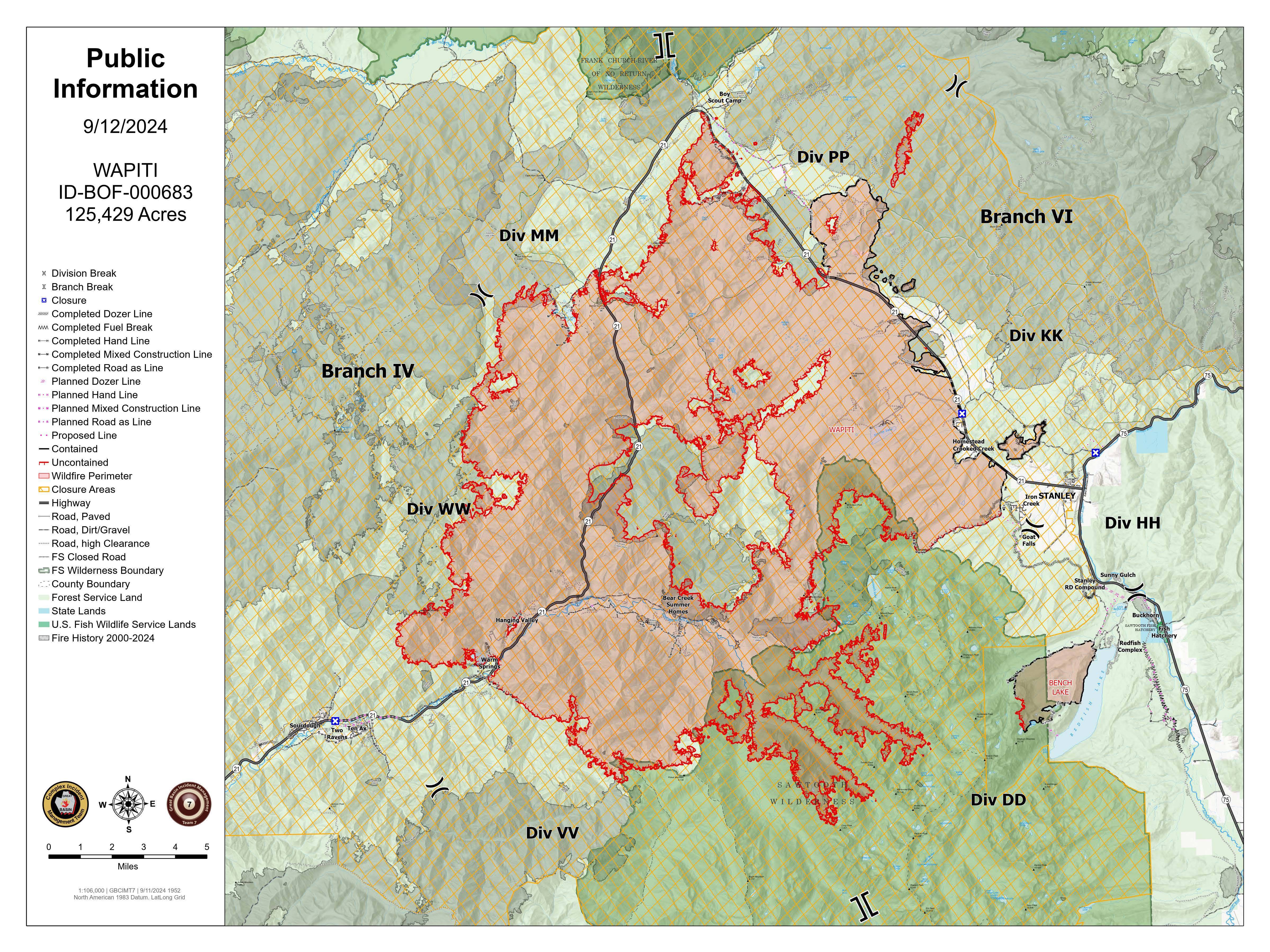
Wapiti Fire Daily Update 09 12 2024
Related Incident:
Publication Type: News
Wapiti Fire Statistics:
Size: 125,429 acres
Containment: 12%
Total Personnel: 1,244
Location: Grandjean, ID
Reported: July 24, 2024
Cause: Lightning
For More Information:
Information Phone: 208-593-7132
Email: 2024.wapiti@firenet.gov
InciWeb: https://inciweb.wildfire.gov/incident-information/idbof-wapiti-fire
Facebook: https://www.facebook.com/wapitifireinfo2024
Linktree: https://linktr.ee/WapitiFireInfo2024
Interactive Map: https://tinyurl.com/WapitiFireInfoMap
Special Notes: State Highway 21 remains closed east of Lowman to Stanley from MP84 (Sourdough Lodge) to MP126 (Stanley Lake turnoff) due to wildfire activity and potential hazards caused by rainfall within the burn area. Highway 75 remains open. A Nevada Type 3 Incident Management Team will in brief today on Frog Fire on the Sawtooth National Forest, for updates on this incident visit the InciWeb page: https://inciweb.wildfire.gov/incident-information/idstf-frog .
Current Situation: Yesterday brought high winds to all areas of the fire ahead of precipitation. Minimal fire activity was observed ahead of the storm front. Today will bring a steady rain, while this will not fully suppress the fire, it will moderate fire behavior. Crews continue to provide protection to various values at risk across the incident. They only engage with the fire where they have a reasonable probability of success. Incident Managers and Agency Administrators from the Forest Service and Idaho Department of Lands continue to meet daily to assess operations and incident objectives.
Division DD: The fire continues to hold within the creek drainages and at the rock scree above the tree line in the Sawtooth Wilderness. Aircraft fly this area of the fire daily, weather permitting, to monitor for hotspots or movement out of the drainages.
Division HH: Crews remain in the Stanley community. Fire lines in the Iron Creek area are holding and crews continue to monitor the division.
Division KK and Structure Group East: Structure protection remains in place and crews monitor the communities to ensure that the fire is not progressing.
Divisions PP & MM: Fire resources maintained a presence along the fire perimeter and continue to monitor the fire along Highway 21. No firing operations were necessary. The area remained fairly quiet through the wind event near Cape Horn and the fire maintained its footprint.
Division WW and Structure Group West: Structure and prep work is complete in Sourdough, Ten Ax, Two Ravens and Middle Lowman. Crews worked to improve lines throughout the communities to prepare for the wind event. Some fire came down above the Warm Spring Guard Station and aviation resources were used to keep the fire from coming down the hill. Fire on Eight Mile Ridge remained in its footprint throughout the wind event. Handline was completed in Eight Mile Creek within an old roadbed from Highway 21 1.5 miles up the canyon. Preparation work is complete on the Jackson Peak Communication Site. Crews assisted with Initial Attack on a single-tree fire near Lowman.
Division VV: Minimal fire activity was observed in this division and the fire continues to hold at Chapman Creek. Due to low potential for fire to spread, aircraft fly this area of the fire daily, weather permitting, to monitor for hotspots or movement out of the drainages.
Weather, Fuels, and Fire Behavior: Yesterday’s storm brought heavy winds, rain and hail. This morning will bring sporadic showers. Temperatures will continue to drop throughout the day and into the evening; low overnight temps will drop into the twenties. Over the next week conditions will continue to cycle between warm/dry and cooler/wet waves.
Evacuations:
For evacuation information on the Wapiti Fire, please see the Custer County Sheriff’s Facebook page at https://www.facebook.com/p/Custer-County-Sheriff-Idaho-61558947312289/ and the Boise County Sheriff’s Facebook page at https://www.facebook.com/boisecountysheriff/.
To sign up for Custer County CodeRED emergency notifications, text CUSTER to 99411 or enroll online at https://public.coderedweb.com/CNE/BF28E45537FF .
To sign up for Boise County Alert Sense emergency notification enroll online at https://public.alertsense.com/SignUp/publicUser.aspx?regionid=1163
Closures and Fire Restrictions:
State Highway 21 remains closed from MP84 to MP126 for public and firefighter safety.
A Wapiti Fire Area Closure / Forest Order: 0414-04-151 for portions of the Boise, Sawtooth, and Salmon-Challis National Forests can be found at this site: https:/www.fs.usda.gov/alerts/sawtooth/alerts-notices.
Boise National Forest Stage 1 Fire Restrictions / Forest Order: 0402-00-63 can be found at this site: https://www.fs.usda.gov/alerts/boise/alerts-notices.
Sawtooth National Forest Stage 1 Fire Restrictions / Forest Order 0414-00-044 can be found at this site: https://www.fs.usda.gov/alerts/sawtooth/alerts-notices
Fire restrictions on federal, state, and private lands may be found at this site: https://www.idl.idaho.gov/fire-management/fire-restrictions-finder/.
Temporary Flight Restriction is in place over the Wapiti Fire. Wildfires are a no-fly zone for unauthorized aircraft, including drones. If you fly, we can’t. For more information, visit http://knowbeforeyoufly.org.
Central Idaho Smoke Outlook 09 12 2024
Related Incident:
Publication Type: News
Special Statement
AIR QUALITY ADVISORIES in effect. See Idaho DEQ for current status.
Fire
Rain fell yesterday and more is expected today on fires in Central and Southwest Idaho. Fire spread will be on "pause" for a few days. However there are still plenty of smoldering stump holes and tree cavities out there which can produce smoke even during a rainstorm. Wildfires in Oregon (a big driver of our air quality this summer) received some rain, but not as much as in Idaho.
Smoke
Conditions will be between GOOD and MODERATE today across the region, except in mountain valleys and drainages closest to the largest fires, where UNHEALTHY FOR SENSITIVE GROUPS will be the likely category. A little more rain in the forecast will help, but the airmass moving in across Oregon still has a hint of smoke in it, making widespread GOOD conditions elusive. A dry weekend will see increased smoldering locally and regionally, with air quality ticking slowly worse. View interactive smoke outlook.