
Actualizacin Sobre Incendio Park Mircoles 11 de Septiembre de 2024 09 11 2024
Related Incident: Park Fire
Publication Type: News
Actualización Sobre Incendio Park: Miércoles, 11 de Septiembre de 2024
Administración De Incidentes Complejos Del Área Suroeste - Equipo 2
John Truett - Comandante Del Incidente
Tamaño: 429,603 acres
Fecha de Inicio: 24 de Julio de 2024
Contencion: 99%
Personal Total: 391
Reparaciones completadas: 185 de 417 puntos de reparación, 5 de 7 millas de línea de mano, 73 de 99 millas de línea de topadora, 66 de 101 millas caminos de línea, 27 de 49 millas de otra línea de reparación.
Recursos: 1 helicóptero, 2 cuadrillas, 3 camiones de bomberos, 2 topadoras, 5 camiones de agua, 1 astilladora, 4 excavadoras, 2 máquinas para talar árboles, 4 minicargadoras, 1 apiladora, 1 retroexcavadora, 2 motoniveladoras
EN HOMENAJE: Hoy se cumple el aniversario de los ataques a nuestra nación en 2001 que resultaron en la pérdida de 2.958 vidas. También es un momento para reflexionar sobre las innumerables personas de todo el mundo que respondieron a los ataques con actos de altruismo y compasión. El Equipo 2 Administración De Incidentes Complejos Del Área Suroeste fue uno de los equipos administrativos de incidentes llamados a la ciudad de Nueva York después de los ataques. Algunos miembros del equipo que respondieron en 2001 todavía están en el equipo hoy.
SITUACIÓN ACTUAL: Esta es la última actualización sobre el incendio Park del Equipo 2 Administración De Incidentes Complejos Del Área Suroeste (SWCIMT2). La línea de información del incendio Park contará con personal hasta las 8 p.m. hoy; A partir de entonces, la Oficial de Asuntos Públicos del Bosque Nacional Lassen, Amber Marshall, será el punto de contacto para obtener información sobre el incendio (530-250-7400, amber.marshall@usda.gov).
Ayer, llegó el equipo 3 de la Organización Nacional de Manejo de Incidentes (NIMO) del Servicio Forestal, recibió un informe y comenzó a recopilar información en preparación para hacerse cargo del incendio hoy. El incidente se administrará con menos personal y recursos, pero continuarán los trabajos de reparación de extinción de incendios. El equipo de árboles peligrosos tiene varios días de trabajo por delante a lo largo de Ponderosa Way. El equipo de reparación de supresión tiene trabajo para mantenerlos ocupados durante al menos una semana en el área al sur de Turner Mountain. El equipo de carreteras tiene varios días de trabajo alrededor de Turner Mountain Loop y el área de Bear Wallow.
CLIMA Y SEGURIDAD CONTRA INCENDIOS: Los vientos de hoy serán racheados y, a medida que avance el día, soplarán desde casi todas direcciones. Las ráfagas máximas podrían alcanzar las 40 mph. Las temperaturas continúan su tendencia a la baja y la humedad aumentará ligeramente, pero el viento supera a la temperatura y la humedad en lo que respecta al comportamiento del fuego. Los vientos en constante cambio generarán humo de corta duración desde dentro del perímetro del incendio. Estos no representarán un riesgo para la contención del fuego. Además, estos vientos traerán árboles enganchados y peligrosos al suelo, por lo que se debe respetar la orden de cierre del bosque. Finalmente, estas condiciones fomentarían la propagación de nuevos incendios, así que tenga especial cuidado al recrear y utilizar equipos al aire libre y tenga en cuenta las restricciones contra incendios aplicables.
CIERRE DE BOSQUES: Algunos terrenos, caminos y senderos del Bosque Nacional Lassen cerca del área del incendio están cerrados temporalmente por la seguridad del público y de los bomberos durante la fase de reparación del incendio. Antes de recrear en sus tierras públicas, consulte la Orden Forestal No. 06-24-07 y el mapa aquí: fs.usda.gov/alerts/lassen/alerts-notices. Es su responsabilidad saber dónde se encuentra en relación con la orden de cierre.
RESTRICCIONES DE INCENDIO: Las restricciones contra incendios siguen vigentes en toda el área. Para más detalles, consulte la Orden Forestal No. 06-24-04 aquí: fs.usda.gov/alerts/lassen/alerts-notices. Conocer las restricciones contra incendios en las áreas donde vive, trabaja o se recrea es su responsabilidad.
Oficina de Asuntos Públicos del Bosque Nacional Lassen:
![]() 530-250-7400, ámbar.marshall@usda.gov
530-250-7400, ámbar.marshall@usda.gov
Información sobre incendio Park (hasta el 11 de septiembre):
530-414-9298 | 2024.park@firenet.gov | linktr.ee/park_fire
West Mountain Fires Closures Evacuation Information Fire Restrictions TFR Important Links September 11 2024 09 11 2024
Related Incident: Boulder FireDollar Fire
Publication Type: Announcement
FOREST CLOSURES
Boise National Forest:
- Closure Order #0402-04-100 Dollar/Oro Area, Trail, and Road Closure – For Forest closure areas over the Dollar fire. For more information visit: https://www.fs.usda.gov/Internet/FSE_DOCUMENTS/fseprd1199005.pdf
- Closure Order #0402-06-60 Anderson-Bulldog-Nellie Fire Area, Road, and Trail Closure – For Forest closure areas over the Goat and Snag Fires. For more information visit: https://www.fs.usda.gov/Internet/FSE_DOCUMENTS/fseprd1201349.pdf
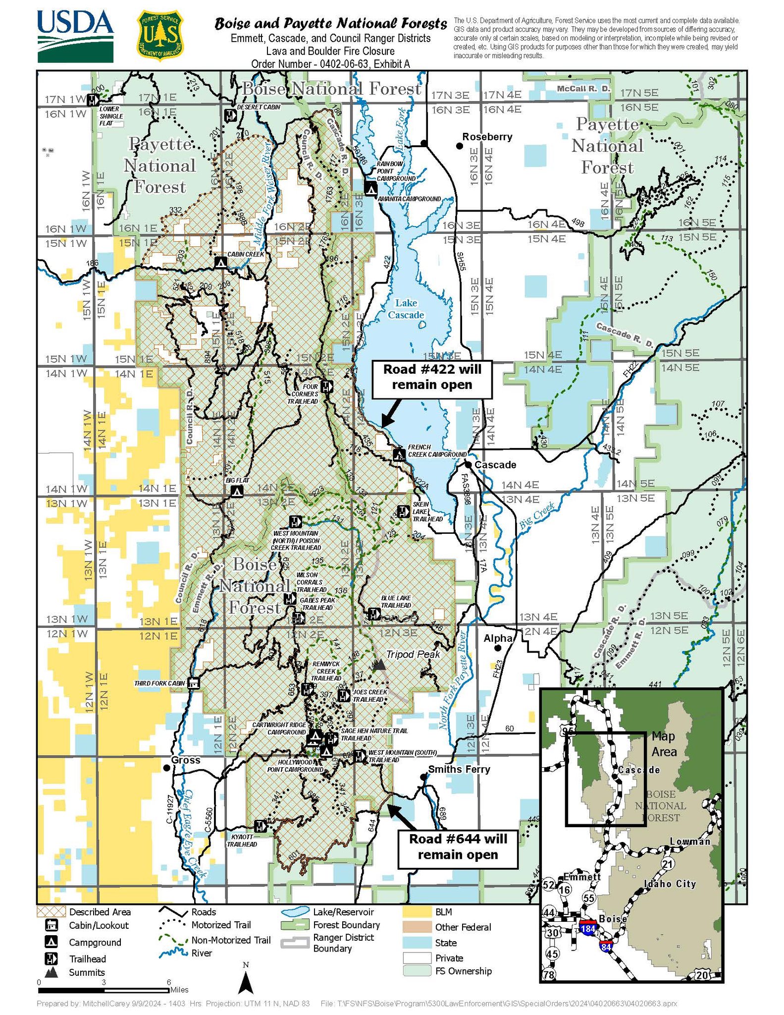
- Closure Order #0402-06-63 Lava Fire Area, Road, and Trail Closure – For Forest closure areas around the Lava and Boulder Fires. For more information visit: https://www.fs.usda.gov/Internet/FSE_DOCUMENTS/fseprd1203488.pdf
Payette National Forest:
- Closure Order #0412-606 Wolf Creek Burned Area Road and Trail Closure - encompassing National Forest System Trail #560 and NFS Road #1762. For more information visit: https://www.fs.usda.gov/Internet/FSE_DOCUMENTS/fseprd1202093.pdf
- Closure Order #0412-605 Dollar Fire Area and Trail Closure - north of Warm Lake Road, west of South Fork Salmon River, east of NFS Trail #101, and south of NFS Trail #99 and #100. For more information visit: https://www.fs.usda.gov/Internet/FSE_DOCUMENTS/fseprd1201446.pdf
FIRE RESTRICTIONS
The Boise National Forest is in Stage 1 Fire Restrictions. For more information visit: Boise National Forest.
EVACUATION INFORMATION
Valley County Sheriff’s Office is responsible for issuing and enforcing evacuation orders, and for determining the boundaries of the evacuation area. Fire managers advise the sheriff when management action trigger points have been breached.
There are currently READY, SET and GO evacuation orders in place. To stay up to date with the most current information, sign up for emergency alerts, such as evacuation notices by visiting your county’s emergency alert system:
- Valley County:(208) 382-5160 https://www.co.valley.id.us/CompleteEmergencyNotificationandAlerting
Contact Valley County Dispatch at (208) 382-5160 for information on evacuation shelters
Review the READY, SET, GO evacuation procedure for Valley County: https://www.co.valley.id.us/ReadySetGo
ROAD CLOSURES
Warm Lake Highway Closure: Piloted access continues. Warm Lake Rd will be opened for homeowners and contractors only. You will need to be on the approved list for travel. If you have already been approved, you do not need to sign up again. To be added to the approved list please visit:
- Valley County: https://www.co.valley.id.us/EscortRequest Or Call: (208) 382-5160
- Active fire behavior continues in the area, please drive slowly, be aware of crews working in the area and watch out for debris.
- National Forest System (NFS) Road 474 is now OPEN from the Boise National Forest boundary to Warm Lake.
TEMPORARY FLIGHT RESTRICTIONS
Temporary Flight Restrictions (TFR) are in place over the Boulder, Dollar, Snag, and Goat Fires. Wildfires are a no- fly zone for unauthorized aircraft, including drones. TFRs are critical for firefighter and aircraft safety. If you fly, we can’t. For more information, visit http://knowbeforeyoufly.org.
Latest version: Sept. 11, 2024
West Mountain Fires Daily Update September 11 2024 09 11 2024
Related Incident: Boulder FireDollar Fire
Publication Type: News
Boulder, 6 miles SW of Cascade, 9,519 acres, 24% contained https://tinyurl.com/ycdfv3tv
Snag, 11 miles E of Cascade, 33,139 acres, 15% contained https://tinyurl.com/4k9dk3mu
Dollar,18 NE of Cascade, 4,338 acres, 8% contained https://tinyurl.com/bef6r3tz
Goat,11 miles SE of Cascade, 25,648 acres 0% contained https://tinyurl.com/2h4a3dvr
Cause: Lightning (All Fires)
Personnel 1012
Special Note: Today, we honor the 343 firefighters who lost their lives responding to the Twin Towers during the terrorist attacks of September 11, 2001. We honor the 55 military personnel killed in the Pentagon 23 years ago today, and every other life lost or forever changed because of 9-11. NEVER FORGET.
The Southern Area Red Complex Incident Management Team will take command of the Lava Fire and the Boulder Fire on Thursday, September 12 at 6am. Lava Fire Information: PH: 208-384-3266 Email: 2024.Lava@firenet.gov
EVACUATIONS: Please check Valley County Sheriff’s Office Facebook or call dispatch at 208-382-5160.
Weather and Fire Behavior:
Today there is a RED FLAG WARNING, 12pm to 9pm due to scattered thunderstorm activity. A cold front moves into the area today, resulting in a shift to westerly winds, cooler temperatures (50s to 60s) and rising humidity. Showers and thunderstorms will likely develop by midday and could bring lightning and gusty, erratic outflow winds. There will be a break mid-afternoon, additional storms expected after 5pm. Storms may be strong with hail. A wetting rain is possible. There will be a reduction in fire behavior overall, with mostly flanking, backing, creeping, and some isolated torching.
Boulder Fire: “Go,” “Set,” and “Ready” evacuation orders are in effect. Learn more: Valley County Sheriff on Facebook.
- Firefighters completed strategic firing operations on the north side of the Boulder Fire.
- A dozer line was completed off the 435 Road around Willow Creek area to help protect the residential area. Structure assessments and preparation are complete here, and engines and firefighters are patrolling this area.
- On the west side of Cascade Lake, the Lava Fire is held up on the ridge, backing down toward the lake. Boulder Fire crews are assessing and preparing structures in the French Creek and God’s Acres areas and have installed sprinkler systems near residences. Firefighters will continue moving northward performing structure assessments.
- On the south side of the fire, crews are chipping debris and patrolling and securing the area.
Dollar Fire:
- The Dollar Fire remains in “monitor” status. Aircraft was not able to fly over the fire yesterday due to smoke.
Snag Fire:
- Roll out (burning logs that roll downhill and can start other fires) is slowly decreasing in the Warm Lake Road area. Firefighters will keep mopping up and securing this area.
- The east side remains hung up in the old burn scars. Firefighters remain near the Fish Hatchery area assessing and preparing structures.
- Mastication is complete on the 474 Road and is now taking place along Bear Creek and Lodge Pole.
Goat Fire:
- The fire remains held up at the 417 Road. Firefighters are scouting for options to construct direct fireline along this northwestern edge of the fire.
- Crews continue preparing the 409 Road and are working to create a dozer line to tie the 409 into the 417. This would create a holding feature if strategic firing operations become necessary to help protect the Horsethief area.
- Structure groups are assessing and preparing structures in the Horsethief area and removing fuels along the Horsethief Rd. as well as other spur roads in the area.
Davis Fire Update 09 11 2024
Related Incident: Davis Fire
Publication Type: News
Southwest Area Incident Management Team Update for Wednesday, September 11, 2024
Acres: 5,646 acres
Start Date: 09/07/2024
Location: Washoe Valley, Nevada
Personnel: 620
Containment: 31%
Fuels: Timber
Resources: 10 Crews | 9 Helicopters | 48 Engines | 2 Water Tenders | 2 Dozers
Highlights: Despite challenging conditions over the past few days, firefighters have achieved 31% containment on the west side of the fire. The National Weather Service has issued a Particularly Dangerous Situation (PDS) Red Flag Warning for the Sierra Front, in effect Wednesday from 11 AM to 8 PM. This is only the sixth PDS warning ever issued by NWS Reno, the last being on September 15-16, 2019—marking this as an exceptionally rare event.
Last night, a successful burnout operation was conducted near Highway 431 to help secure fire lines. Firefighters continue to provide structure protection in all affected communities. Additional firefighting resources from across the country are arriving to bolster efforts.
Aircraft were fully operational throughout yesterday’s shift, playing a vital role in supporting ground crews. However, today's aerial operations will be limited due to wind and smoke conditions. As of yesterday, rotor-wing aircraft delivered 208,000 gallons of water, with Super Scoopers contributing 196,000 gallons. Additionally, fixed-wing aircraft dropped 98,000 gallons of fire retardant. Dozer lines have been constructed near the Sky Tavern area, as well as to the north and south of Highway 431.
Fire Activity: Yesterday, active fire behavior was observed along the southwestern portion of the fire, near Mount Rose Highway. There was minimal activity on the north and northeast sides of the fire. Crews will continue to strengthen lines in and around the northwest side. The majority of the heat has been in the western side of the fire. With predicted high winds, dry fuel conditions, and slope alignment, fire managers anticipate extreme fire behavior, including potential movement to the north and long-range spotting. Forecasted high winds present a major operational challenge, particularly in the northern areas.
Weather: Extreme fire conditions are predicted due to the Particularly Dangerous Situation (PDS). The temperatures will range from 66-71 degrees with southwest winds sustained at 25-40 MPH and gust up to 60-70 MPH. The peak of the wind event will be later in the afternoon. Once the inversion lifts and temperatures rise fire activity will increase.
Evacuations: We urge everyone to remain vigilant and stay clear of evacuation zones. If you choose to shelter in place during today's PDS, you may be putting yourself and firefighters at greater risk, while also slowing the progress of firefighting efforts. Stay informed by relying on official fire information sources. For updates on evacuation statuses please visit: https://perimetermap.com
Updated Boise National Forest Closure Order For Middle Fork Complex September 11 2024 09 11 2024
Related Incident:
Publication Type: Closures
An updated Boise National Forest Closure Order Number 0402-06-64 is in effect. The closure now clarifies that Forest Road 582 (Clear Creek) out of Lowman is closed.
Hunters (whether permitted or not) are not allowed access to these closed areas.
Fossil Complex Evening Update 09 10 2024
Related Incident: Fossil Complex
Publication Type: News
BREEZES FAN FLAMES OF THE SERVICE FIRE AGAIN ON THE FOSSIL COMPLEX
SPRAY, Ore. – Firefighters working the day shift were able to hold the fire on the east side of ORE19 through another day of challenging firefighting weather. Gusts of up to 20 MPH pushed the actively burning head of the fire to the southeast and across Winlock Road toward the Lone Rock Fire scar. On other parts of the fire, building off of the advances of a productive night shift, crews were able to improve the security around structures and firelines along many parts of the northern and eastern flanks. Throughout the shift, crews used direct and indirect attack to add line and security to the fire where opportunity was available. Aerial resources worked in tandem with crews on the ground and dropped retardant to improve the stopping power of dozer line.
Evacuation levels were increased by the Wheeler County Sheriff's Office today. Please check their Facebook page for the latest information. https://www.facebook.com/WheelerCountySheriffsOffice/
Securing the fire on the east side of ORE19 overnight is a priority. Firefighters will also seek opportunities to stop the fire’s advance to the southeast when conditions are expected to become more favorable, around midnight. The weather forecast for tomorrow promises cooler temperatures and a good chance of wetting rains by mid-morning and throughout the day.
Mop up will push deeper into the interior on the Kinzua and Canyon Fires, which are progressing toward patrol status. The Two Cabin and Holmes Fires are now in patrol status.
Community Meetings:
Fossil: September 11th at the Fossil Elementary School Gymnasium, 6:30 PM. Please use the west entrance. The meeting will be recorded and posted to: https://www.facebook.com/fossilcomplexfire
Spray: Due to the closure of ORE19, a public meeting in Spray is planned for Thursday 12th at The Rock, 601 Willow St. at 6:30 PM.
Flying unauthorized drones is hazardous to aircraft and will ground critical aerial operations.
FIRE AT A GLANCE
Fossil Complex
Total Size: 15,552 acres
Two Cabin-251acres
Canyon-190 acres
Kinzua-96 acres
Holmes-15 acres
Service- 15,000 estimated
Containment: 3%
Cause: Lightning
Current Cost: $7.4 M
All Resources
Hand Crews: 36
Engines: 35
Water Tender: 12
Dozers: 25
Skidders: 7
Skidgen: 3
Excavator: 2
Feller Buncher: 4
Total Resources: 1070
Aerial Resources
Type 1: 3
Type 2: 5
Type 3: 3
Evacuations:
Level 1: 21 addresses
Level 2: 85 addresses
Level 3: 156 addresses
https://www.facebook.com/WheelerCountySheriffsOffice/
ODF Incident Commander:
Matt Howard, Incident Management Team 2
Devils Knob and Milepost 98 Fires Morning Update 09 11 2024
Related Incident:
Publication Type: News
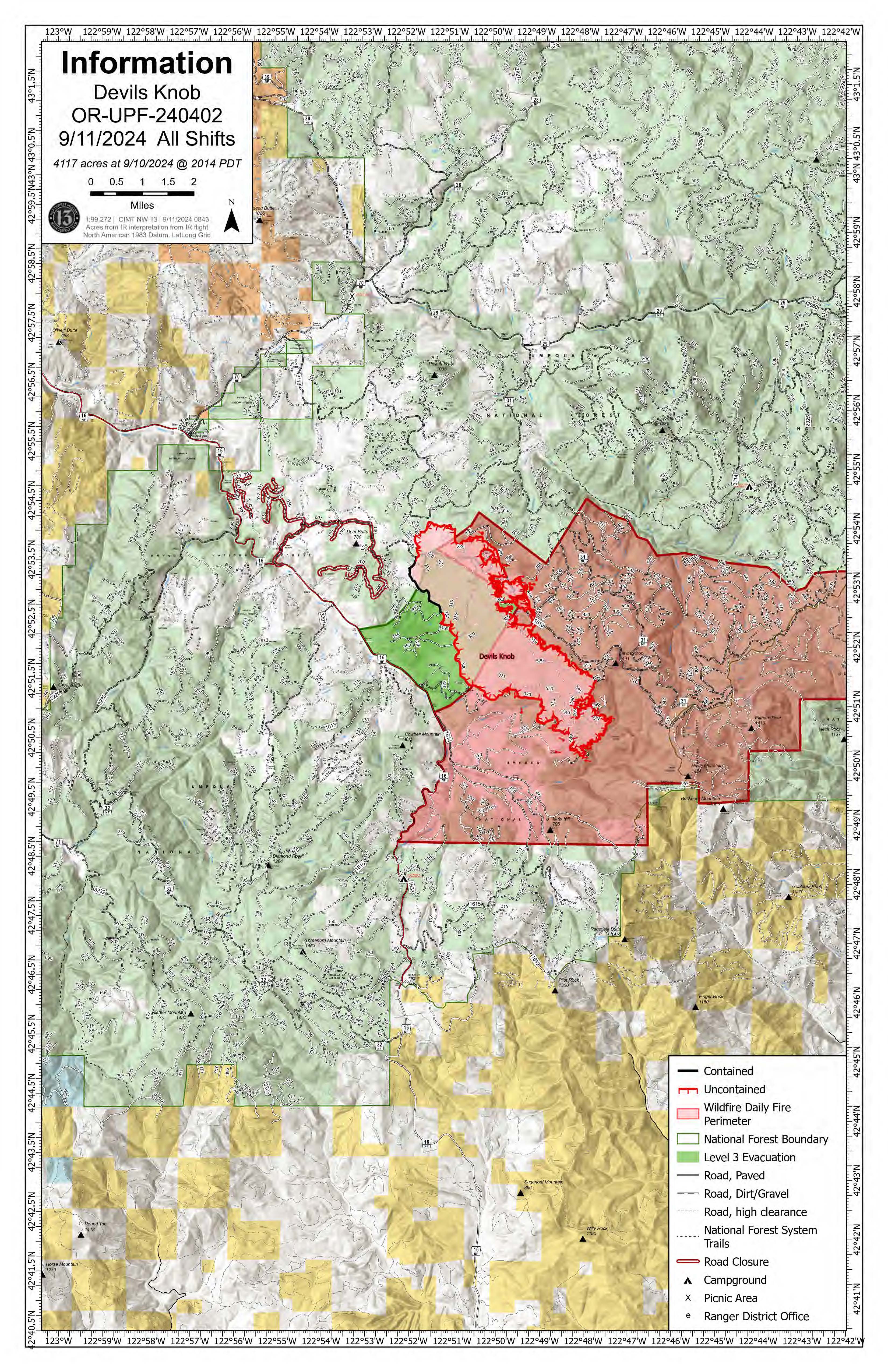
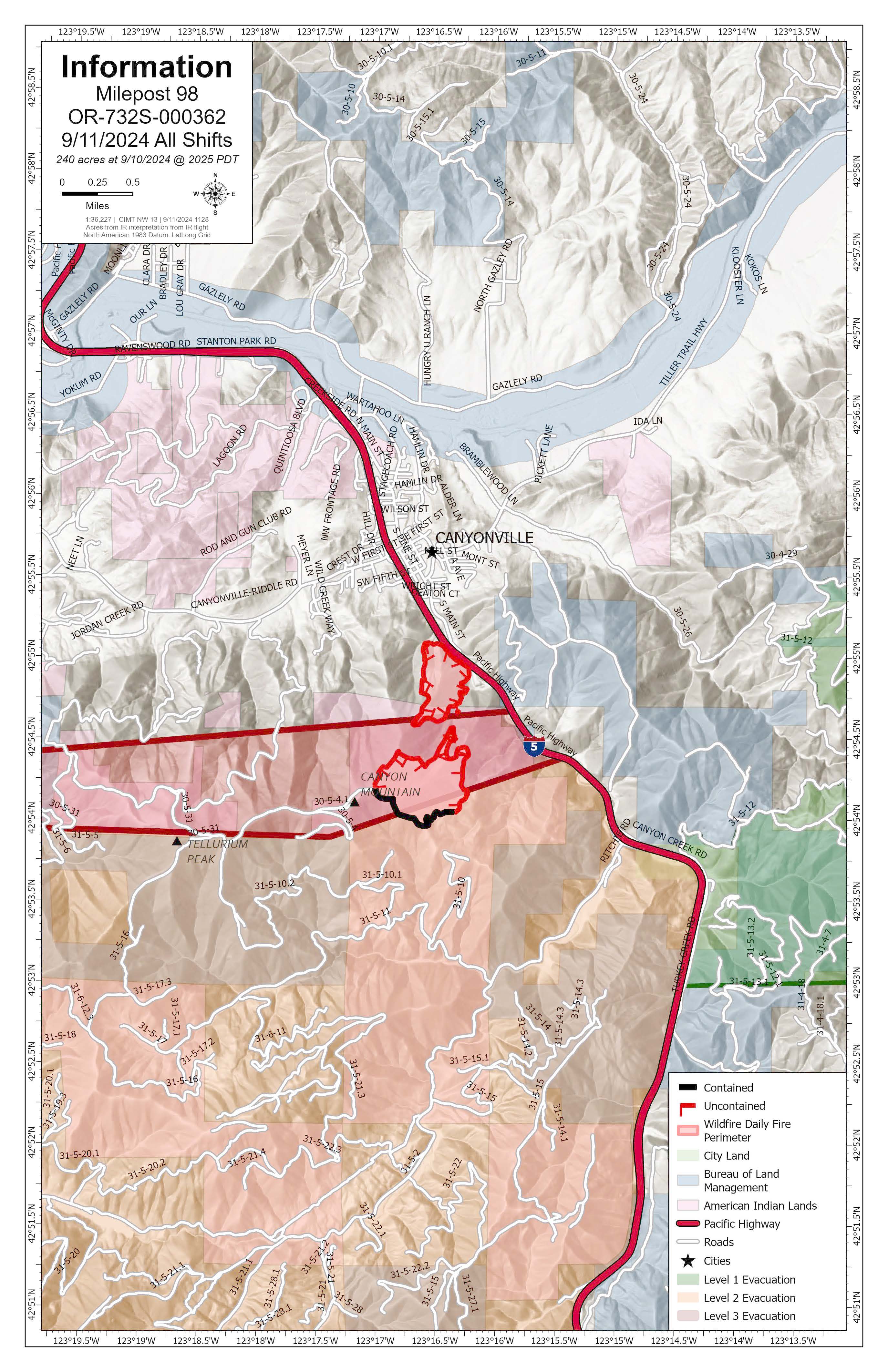
Devil’s Knob and Milepost 98 Fire Update for Wednesday, September 11, 2024
KEY MESSAGES:
Evacuation levels from the Douglas County Sheriff’s Office have changed. An interactive map can be found at their website, https://www.dcso.com/EVACUATIONS. Residents are encouraged to sign up for emergency notifications through Douglas County Emergency Management, found at https:// www.dcso.com/254/Emergency-Notification-System. Currently, no level 3 evacuations exist. Level 2 evacuations include all residences on Joe Hall Road, all residences on Tison Road, all residences on Elk Diamond Road, and all residences on Ritchie Road. Level 1 evacuations include all residences on the East side of Tiller Trail Hwy between the 34000 to 36760 block. Cancelled evacuation notices include all residential addresses on Canyon Creek Road.
CIMT NW 13 will hold a public meeting tonight at 7:00 p.m. at the South Umpqua Community Church; 27292 Tiller Trail Hwy, Days Creek, OR 97429. This meeting will be recorded and posted to Facebook afterward for those unable to attend.
CURRENT STATUS:
Devil’s Knob- Resources: 612 Crews: 17 Engines: 16 Water Tenders: 10
Yesterday, crews worked on mopping up the northwest corner of the fire, west of Hamlin Prairie. Direct suppression actions were successful on the spots around the Devil’s Knob perimeter. Aviation resources focused on the southeast flank of the fire around Flat Creek to allow crews to prep line as the fire backed down to the 300 Road. Incident personnel worked to protect the powerline to the south. Today, the goal is to create more depth in mop-up operations from hand and dozerline to bolster containment efforts. If weather allows, resources will also work to create direct line in the Flat Creek area.
Milepost 98- Resources: 337 Crews: 13 Engines: 13 Water Tenders: 13
In the interior of the fire, a 30-acre island remains unburned. On the eastern edge of the fire, about a mile northwest of Ritchie Road, crews and equipment are working to complete a section of critical dozerline. Direct suppression action will be focused on the southeast corner of the fire as the western flank is being mopped up.
WEATHER / FIRE BEHAVIOR:
A cold front will bring moisture to the fire area today, with potential of a half inch to an inch of rain and gusty winds. There will also be a 20-30% chance of thunderstorms. A drying trend will start Thursday, but more moisture is expected toward the end of the weekend. Minimal fire growth is expected for both fires due to increased relative humidity.
SAFETY AND CLOSURES:
There are two closures impacting every district of the Umpqua National Forest, including a new closure for the Devil’s Knob Fire. These can be found at https://www.fs.usda.gov/alerts/umpqua/alerts-notices. While all lanes on I-5 are open between Milepost 97 and 98, the right shoulder remains closed for firefighter safety. Please use extra caution when driving due to the wet weather, which also includes increased potential for rollout debris in areas impacted by wildfire.
Actualizacin del incendio Whisky Creek Sandstone y Blister Creek 09 11 2024
Related Incident: Whisky Creek FireSandstone Fire
Publication Type: News
Tamaño de Whisky Creek: 3,047 acres | Fecha de inicio: 20 de julio |Causa: De orígen humano |Contención 25%
Tamaño de Sandstone: 702 acres | Fecha de inicio: 5 de agosto | Causa: Rayo | Contención 75%
Total de recursos: 295 | Equipos de obreros: 4 | Camiones de bomberos: 7 | Topadoras: 2 | Maquinarias pesadas: 11 | Helicópteros: 1
Los incendios Whisky Creek, Sandstone y Blister Creek arden en un terreno escarpado y escabroso en el Bosque Nacional Mt. Hood, donde los escombros rodantes y los árboles que han sido debilitados por el fuego dificultan el trabajo de extinción. Se ha logrado mucho trabajo en los incendios, y hay una alta probabilidad de que se podrá contener el fuego dentro del área actual. Se prevé que crecerá un poco debido a las condiciones meteorológicas previstas.
Hoy será el último día en que el Equipo 12 del Noroeste estará asignado al incendio. Este desea agradecer a la comunidad local por haber albergado nuestro puesto de comando de incidentes y apoyado nuestros esfuerzos. Un equipo local de Tipo 3 tomará responsabilidad del incendio Whisky Creek, mientras que los incendios Sandstone y Blister Creek cambiarán a una organización local de Tipo 4.
Whisky Creek: Ayer, el incendio creció poco y la mayor parte de actividad fue en la ladera sur en las aguas cabeceras del arroyo Herman. Los bomberos llenaron tanques de agua portátiles al bombear agua del lago Wahtum por la manguera que se extendía a lo largo de la ladera sureste. La nivelación continuó cerca del embalse de Green Point y las maquinarias pesadas terminaron de reparar la línea de topadoras entre los caminos del Servicio Forestal (FSR) 2820 y FSR 630. Mañana, un asesor de recursos inspeccionará el trabajo de reparación por la extinción de incendios. La lluvia pronosticada calmará la intensidad de los incendios, pero continuará el humo de los combustibles pesados ardientes.
Sandstone y Blister Creek: Ayer apareció humo en varios sitios nuevos dentro del perímetro este del incendio Sandstone. Los bomberos encontraron agujeros de troncos ardientes cerca del cortafuegos y neutralizaron este humo para eliminar cualquier amenaza a las líneas de contención que se habían establecido. Es posible que se vea más humo a medida que los combustibles del interior sigan ardiendo. Mañana, las maquinarias pesadas continuarán trabajando en el FSR 7015, así como en la reparación de líneas de topadoras y líneas manuales.
Clima: Se ha desplazado al área un sistema meteorológico más húmedo y se espera lluvia en toda el área, además de temperaturas más frescas y vientos racheados que soplarán del oeste / suroeste. Este sistema desparecerá de la zona el jueves. Para ver el pronóstico de humo y seguridad, consulte: oregonsmoke.org.
Cierres: Los cierres de áreas permanecerán en el Bosque Nacional Mt. Hood, el Área Escénica Nacional Columbia River Gorge y el Condado de Hood River. Se establecen cierres para la seguridad del público y de los bomberos; La intrusión en un área de cierre puede interrumpir las actividades de extinción y reparación de incendios, poner en peligro vidas y propiedades, y puede resultar en multas. La información de cierre se encuentra en: https://linktr.ee/whisky_creek.2024.
Seguridad: El público juega un papel importante en la prevención del próximo incendio forestal; tenga cuidado con cualquier posible fuente de incendio. Para obtener consejos de prevención, consulte: https://keeporegongreen.org. La TFR sigue vigente para ambos incendios: https://bit.ly/3T59VWv. Las restricciones contra incendios están vigentes dentro del Bosque Nacional Mt. Hood. Se puede ver más información en: https://www.fs.usda.gov/main/mthood/fire.
Coffee Pot Daily Update 09 11 2024
Related Incident: Coffee Pot Fire
Publication Type: News
Unified Command: CAIIMT15 & CAL FIRE
Fire Size: 13,715 acres
Percent Contained: 37%
Primary Strategic Control Line: 96%
Personnel: 1,067
Cause: Lightning
Start Date: Saturday, August 3, 2024, at 10:05 a.m.
Location: Southeast of Three Rivers, CA
COFFEE POT FIRE PUBLIC MEETING: CIIMT 15 will host a public meeting about the Coffee Pot Fire tomorrow, Thursday, September 12th, at 6:00 PM at the Three Rivers Memorial Building: 43490 Sierra Drive, Three Rivers. Those unable to attend can watch the meeting live on the Sequoia and Kings Canyon National Parks Facebook page ( @SequoiaKingsNPS) or YouTube channel (@sequoiaandkingscanyonnps5018).
CURRENT SITUATION: Yesterday, due to hot, dry, and windy conditions the fire breached control lines along Horse Creek and east of Eden Creek. Previously established retardant lines limited the fire’s spread along Horse Creek and hotshot crews quickly constructed a new control line around the area east of Eden Creek while air operations conducted tactical water drops to support their efforts. South of Horse Creek, low-intensity firing operations and additional retardant were used to strengthen the control line. Firefighters on the southern and western flanks focused on reinforcing fire lines, gridding for hotspots, and backhauling equipment from contained sections of the line. On the northern flank, road preparation continued along Mineral King Road, east toward Silver City.
Today on the northeast portion of the fire, hotshot crews will continue constructing and strengthening direct control line north toward Horse Creek and south around Homers Nose with assistance from aviation assets. Firefighters will monitor the line and continue backhaul and mop-up efforts along the southern and western flanks. Chipping operations and road improvement will continue along Mineral King and Salt Creek Road.
WEATHER: An area of low pressure will bring cooler temperatures today along with gusty winds. Morning drainage winds will shift to an upcanyon flow by mid-morning and increase in speed in the afternoon. Winds will be west along the East Fork Kaweah River, but turn to a more northwest direction up Horse Creek near the confluence of the two drainages.
SMOKE IMPACTS: Due to the forecasted winds and fire established on the east of Horse Creek, increased fire activity is expected today leading to increased smoke production. Areas north of the fire will see poor air quality this morning, with clearing late afternoon as the inversion lifts. Air quality will be poor again overnight and through the morning with conditions being in the UNHEALTHY for SENSITIVE GROUPS range and possibly UNHEALTHY conditions in Three Rivers, Hammond, and Giant Forest. For more information on current wildfire smoke impacts in your community, please visit AirNow.gov or fire.airnow.gov.
EVACUATION NOTICES: The Tulare County Fire Department has issued Evacuation WARNINGS for zones TLC-E094-B, TLC-E094-C, TLC-E094-D, TLC-E094-E, and TLC-E095. To find your zone, please refer to: protect.genasys.com
FIRE INFORMATION: A Public Information Officer will be at the Three Rivers Village Market daily from 10:30 a.m. to 4 p.m. to provide fire information and answer questions.
BLM AND PARK CLOSURES: The portion of South Fork Drive within Sequoia and Kings Canyon National Parks and trails accessed from the road, including the Ladybug and Garfield Grove Trails, are closed. Recreational access to the Mineral King area of Sequoia National Park is closed to the public. This applies to Mineral King campgrounds, trailheads, and area trails. All other areas of the parks are open but are likely to be impacted by varying levels of smoke and poor air quality. Park closure information is available online at nps.gov/seki. The Bureau of Land Management has also issued a closure of the Case Mountain Extensive Recreation Management Area at blm.gov/press-release.
PUBLIC NOTICE: Wildfires are a no-fly zone for unauthorized aircraft, including drones. If you fly, we can’t. For more information, visit knowbeforeyoufly.org.
Rail Ridge Fire Update September 11 2024 09 11 2024
Related Incident:
Publication Type: News
Closures and Evacuations
Closures: The Forest Service and BLM have implemented partial closures due to the Rail Ridge Fire and Crazy Creek Fire, for all uses. For more details and closure maps, visit the Ochoco National Forest, Malheur National Forest, and BLM web pages.
Evacuations: Shelters are available to evacuees. For up-to-date evacuation information, please visit:
- Crook County: Crook County Emergency Management website and Crook County Sheriff’s Office Facebook page.
- Wheeler County: Visit the Wheeler County Sheriff’s Office Facebook page for real-time updates.
- Grant County: Grant County Emergency Management Facebook page.
Operational Update
Today, the focus is on the Dayville and Morgan Mountain areas. Firefighters will look to take advantage of opportunities presented by moderating weather conditions and build upon the significant progress made this week. Along the north end of the fire, crews are working to establish solid containment and reduce the danger to Dayville. OSFM will begin mopping up around structures in areas nearest to the fire line. On the northwest portion of the fire near Battle Creek, the fire continues to move slowly through light fuels and resources will be assessing options to utilize heavy equipment to improve access points for crews near the wilderness area. At the slop over near Morgan Mountain Ranch, crews are seeking opportunities to go direct and reinforcing containment plans while OSFM task forces provide structure protection. On the south, and southwest portion of the fire, crews will continue to patrol and aggressively mop up where fire activity has been minimal for several days. Weather permitting, air resources will be available to assist with suppression efforts throughout the day.
Overnight, crews held the fire and built upon the progress made during day shift. Portions of the fire received gusty winds in the evening, including the area of the South Fork of the John Day, where the terrain has presented challenging access for firefighters. The Aldrich Lookout area became inaccessible during the night due to hazardous road conditions, and work to clear this roadway will resume today. Crews on the eastern fire line reported no significant fire activity, with fuels burning out as anticipated. The area near Morgan Mountain did not receive the night-time moisture recovery that was expected, and the firefighters were unable to go direct. Crews in this area focused on prepping and reinforcing primary control lines and crews will look for opportunities today to go direct during calmer weather.
Yesterday, favorable weather conditions contributed to significant progress. Crews took advantage of cooler temperatures to complete burn operations near South Fork Road and Guyon Basin, behind the community of Dayville. This tactical process removes fuels from the path of the fire in a controlled fashion, ultimately reducing intensity and spread. Structure resources supported wildland resources and protected structures in the immediate area. The burn operation was wrapped up during the night, and crews reported minimal further fire growth in this area.
Along the eastern edge of the fire perimeter, near the Fields Creek area, resources focused on establishing and improving control lines. On the 2150 road, fallers worked to remove hazard trees and keep roadways clear to ensure access to structures and critical communications infrastructure. Oregon State Fire Marshal (OSFM) resources continued to expand and improve structural hardening measures throughout the Dayville, Fields Creek, and South Fork Road areas. These crews have triaged over 470 structures and continue to increase this numbers daily. Their completed preparation work includes fuels reduction, debris clearing, the placement of portable pumps and water sources, and the installation of sprinkler systems where appropriate. This process also includes pre-planning defense strategies, identifying engine access and establishing firefighter safety zones.
On the southeast portion of the fire, air resources supported suppression in the Morgan Mountain area, where firefighters continued to work on containing a spot fire and built contingency line. OSFM task forces supported wildland operations in this area and expanded prep work to include additional structures. In the community of Izee, power was restored. A community meeting is planned at the Paulina Community Center, for Thursday, at 5:00 p.m.
Weather
A cold front will move across the region today, bringing cooler temperatures, higher humidity, and a chance of wetting rains. Gusty winds and thunderstorms are possible in the afternoon, with more wetting rain expected on Thursday morning.
With weather moderating, fine fuels will be less receptive and slower rates of spread are expected. Seasonably cool conditions should continue through the end of the week.
#####