
Sharrott Creek Fire Update 09 11 2024
Related Incident:
Publication Type: News
Northern Rockies Team 5, Incident Commander Joe Sampson
Location: Three miles west of Stevensville, Montana
Start Date: 8/23/2024
Cause: Lightning
Size: 3,204
Completion: 36%
Total Personnel: 346
Current Status
Crews continue to secure and make improvements to the northern-most section of fireline to the head of Larson Creek. Along the southern-most section of fire line towards the St. Mary’s Trailhead, crews continue to ‘mop-up’ hot spots and make improvements.
Weather and Fire Behavior
Hot and dry conditions will continue for the morning with temperatures reaching the low 70s by noon. Thunderstorms are expected in the early afternoon with potential gusty winds up to 45 mph and possible small hail. The weather system is expected to weaken as it travels north through the Bitterroot Valley towards the Sharrott Creek Fire, but a strong to severe thunderstorm is still possible. Storm activity will likely end before midnight and periods of rain will continue in the valley with a chance of mixed precipitation above 9,000 feet.
Fire activity will remain moderate to potentially active in some areas with torching and short-range spotting possible prior to the incoming wet weather and increased winds. As weather patterns change and moisture increases, fire behavior will be limited over the next 24 hours to 48 hours.
EVACUATIONS, RESTRICTIONS, CLOSURES
-The Ravalli County Sheriff’s Office has issued an Evacuation Warning for neighborhoods in the vicinity of the Sharrott Creek Fire. Sign up for evacuation alerts at http://hyper-reach.com/mtravallisignup.html
- Area closures are in effect from North Fork Sweeney Creek to Sweathouse Creek. More information on Bitterroot National Forest area closures can be found at: https://www.fs.usda.gov/alerts/bitterroot/alerts-notices
- The Bitterroot National Forest is currently in Stage I Fire restrictions within the Anaconda Pintler Wilderness.
- A Temporary flight restriction (TFR) is in place west of Highway 93 from Bass Creek to Big Creek.
West and Preacher Fires Update 09 11 2024
Related Incident: 2024 - Preacher Fire - TNF2024 - West Fire - TNF
Publication Type: News
Use caution driving as smoke settles into communities around West and Preacher fires
Highlights/Operations: Residents noticed increased smoke from both the West and Preacher Fires yesterday due to the increase in ignitions. On the Preacher Fire, crews were able to ignite within the entire planned perimeter. They were assisted by a helicopter with ignition capabilities that added additional fire to the interior. Everything held within the planned perimeter and crews continued patrolling and mopping up the edge of the perimeter as needed throughout the night. On the West Fire, firefighters continued igniting the northeast corner of the planned area ahead of the anticipated winds. They were able to bring fire across the Rim to the top of Bray Creek and hold everything. Helicopters with water buckets assisted in keeping the fire in place on the fire’s western edge. This is part of the strategy to ignite the West Fire area in sections to reduce smoke impacts to communities and improve fire benefits to the ecosystem.
Today, crews and engines will focus on holding the perimeter across the Preacher Fire. In any areas where it is needed, firefighters will secure and mop up. On the West Fire, firefighters will secure, mop up and hold the perimeter on the northeast corner. Crews are also adding protection to water lines and spring boxes above Camp Geronimo. Across the rest of the West Fire, they are improving the perimeter lines and testing structure protection watering systems. With the anticipated increased winds, there likely will not be additional ignitions today. However, fire managers will reassess throughout the day.
Weather: Winds will increase for Wednesday and Thursday out of the southwest. Expect frequent afternoon gusts to 25 mph on Wednesday and gusts up to 30-35 mph on Thursday. Wednesday will feature a sunny sky with near-normal high temperatures in the upper 70s to mid 80s. Minimum relative humidity values will range between 15 and 22 percent. Sunny again on Thursday but not quite as warm. High temperatures are forecasted to be in the mid 70s to low 80s.
Safety: Two Temporary Flight Restrictions (TFR) are now in place over the area, which includes uncrewed aircraft systems or drones. The public is reminded, if you fly we can’t; unauthorized drone flights pose serious risks to firefighter and public safety and the effectiveness of wildfire suppression operations.
Closure: The Tonto National Forest has issued a closure for land surrounding the West Fire, this includes Pine Trailhead.
Evacuations: Some residents east of Payson near the Preacher Fire have been moved to SET status and Geronimo Estates residents near the West Fire have also been placed in SET status. An interactive map is available to stay up to date with evacuation levels related to both the West and Preacher Fires.
Receive emergency notifications from Gila County.
Smoke: During ignitions, smoke may settle in low-lying areas overnight. Residents are encouraged to close windows at night to avoid smoke impacts. Talk with your doctor and plan for how to manage your health conditions when it is smoky. Additional resources for how to prepare for wildfire smoke.
For the latest news and information about the Tonto National Forest, follow along on Facebook @TontoNationalForest, ‘X’ (formerly Twitter) @TontoForest or Instagram @tontonationalforest and on the Tonto National Forest website.
Wednesday September 11 2024 RailroadDaly Fire Update and Map 09 11 2024
Related Incident:
Publication Type: News
CURRENT STATUS The Daly Fire advanced moderately northeastward along Stony Creek in Ravalli and Granite counties. Firefighters continued assessing the eastern flank in the Gem Mountain and Rock Creek areas. Resources including heavy equipment and water tenders have been positioned to protect the values at risk north and east of the fire.
The Railroad Fire experienced moderate growth to the east however, with low vegetation and continuous rock scree overall fire behavior remains limited.
WEATHER AND FIRE BEHAVIOR
Warm and dry conditions will continue through the morning with temperatures reaching the low 70’s. Fire activity will be less than previous days, but torching and short-range spotting could continue. Thunderstorms are likely to arrive in early afternoon bringing erratic wind gusts of up to 35 mph and the possibility of pea-sized hail. Precipitation may bring enough moisture to limit fire behavior with creeping expected to continue in heavy fuels. Flash flooding and debris flow is a potential concern as storms move in.
EVACUATIONS, RESTRICTIONS, CLOSURES
The Skalkaho Highway (Highway 38) is closed from Black Bear Campground to the Crystal Creek Campground on the Beaverhead-Deerlodge NF side. This location has the potential to change, given the amount of recent fire activity. The temporary flight restriction (TFR) on the Railroad-Daly fire has expanded both north and south. Gird Point Lookout is also closed.
Wapiti Fire Daily Update September 11 2024 09 11 2024
Related Incident:
Publication Type: News
Wapiti Fire Statistics:
Size: 125,429 acres
Containment: 12%
Total Personnel: 1,325
Location: Grandjean, ID
Reported: July 24, 2024
Cause: Lightning
For More Information:
Information Phone: 208-593-7132
Email: 2024.wapiti@firenet.gov
InciWeb: https://inciweb.wildfire.gov/incident-information/idbof-wapiti-fire
Facebook: https://www.facebook.com/wapitifireinfo2024
Linktree: https://linktr.ee/WapitiFireInfo2024
Interactive Map: https://tinyurl.com/WapitiFireInfoMap
Special Notes: State Highway 21 remains closed east of Lowman to Stanley from MP84 (Sourdough Lodge) to MP126 (Stanley Lake turnoff) due to wildfire activity. Highway 75 remains open. The Frog Fire on the Sawtooth National Forest is putting up significant smoke visible from Stanley. Currently this fire is being managed by the Sawtooth National Forest with resources on loan from the Wapiti Fire. For the most up to date information on the Frog Fire, visit: https://inciweb.wildfire.gov/incident-information/idstf-frog.
Current Situation: The next few days will bring a strong weather system through the area. Ahead of the precipitation there will be critical fire weather and an uptick in fire activity. Aerial resources are identifying heat zones across the fire ahead of these strong winds. A significant amount of precipitation is expected to fall over the Wapiti Fire. Although this rainfall will not extinguish the fire, it is expected to moderate fire behavior and increase the moisture levels of burnable fuels. Despite this change in weather, crews will continue to staff the fire day and night to meet incident objectives. Firefighter and public safety remain the highest priority in all management decisions.
Division DD: An indirect dozer line and fuel break has been completed from Iron Creek all the way down to the 2014 Gold Fire burn scar. This will serve as the holding feature if the fire moves out of the Sawtooth Wilderness. Currently, the fire is holding in the creek drainages and at the rock scree above the tree line. This area of the fire is being flown daily to monitor for any hotspots or movement out of the drainages.
Division HH: Crews remain in place patrolling the community of Stanley. All the line around Iron Creek is holding. Aviation resources have been flying this division daily to look for hotspots.
Division KK and Structure Group East: Structure protection is in place and crews continue to monitor the communities and ensure there is no fire progression. Crews are mopping up any hotspots and monitoring the area. Fire behavior increased yesterday, and vegetation was more receptive to fire and burned in the interior of the perimeter.
Divisions PP & MM: Today, crews have completed firing operations in this area and are working to secure the fire perimeter. They continue to monitor the area and mop up hotspots. Unmanned Ariel Systems (UAS) were used to detect any heat in the area and assist with mop up.
Division WW and Structure Group West: Structure protection in upper and middle Lowman, including the Sourdough, Ten Ax and Two Ravens subdivisions are completed. Yesterday, the Warm springs area had active fire behavior on the Eight Mile Ridge where fire is backing down towards the Warm Springs Guard Station. Aircraft are being utilized for bucket drops to cool hot spots in the area. Plans are in place in case conditions change or fire behavior increases. Unmanned Ariel Systems (UAS) were utilized to detect heat in the area.
Division VV: Fire in this division is burning partially within the Sawtooth Wilderness and is unstaffed due to the lack of road access and low potential for fire spread. It is being flow daily to monitor any fire progression.
Weather, Fuels, and Fire Behavior: There is a Red Flag Warning in place for today from noon till 2pm. Ahead of the storm, winds may gust up to 60mph which could cause an increase in fire behavior. The next storm system will arrive around 4pm, causing an acute drop in temperatures, with increasing thunderstorms, and possible hail and rain up to ¾ of an inch. A steady rain will persist throughout the day on Thursday. With this significant amount of rainfall, there is a risk of debris flows off the burned area that could inhibit the passage of fire crews through the Highway 21 corridor.
Evacuations:
For evacuation information on the Wapiti Fire, please see the Custer County Sheriff’s Facebook page at https://www.facebook.com/p/Custer-County-Sheriff-Idaho-61558947312289/ and the Boise County Sheriff’s Facebook page at https://www.facebook.com/boisecountysheriff/.
To sign up for Custer County CodeRED emergency notifications, text CUSTER to 99411 or enroll online at https://public.coderedweb.com/CNE/BF28E45537FF .
To sign up for Boise County Alert Sense emergency notification enroll online at https://public.alertsense.com/SignUp/publicUser.aspx?regionid=1163
Closures and Fire Restrictions:
State Highway 21 remains closed from MP84 to MP126 for public and firefighter safety.
A Wapiti Fire Area Closure / Forest Order: 0414-04-151 for portions of the Boise, Sawtooth, and Salmon-Challis National Forests can be found at this site: https:/www.fs.usda.gov/alerts/sawtooth/alerts-notices
Boise National Forest Stage 1 Fire Restrictions / Forest Order: 0402-00-63 can be found at this site: https://www.fs.usda.gov/alerts/boise/alerts-notices.
Sawtooth National Forest Stage 1 Fire Restrictions / Forest Order 0414-00-044 can be found at this site: https://www.fs.usda.gov/alerts/sawtooth/alerts-notices
Fire restrictions on federal, state, and private lands may be found at this site: https://www.idl.idaho.gov/fire-management/fire-restrictions-finder/.
Temporary Flight Restriction is in place over the Wapiti Fire. Wildfires are a no-fly zone for unauthorized aircraft, including drones. If you fly, we can’t. For more information, visit http://knowbeforeyoufly.org.
Daily Update for the Chimney Fire 09 11 2024
Related Incident: Chimney Fire
Publication Type: News
A fire weather watch has been issued for today due to forecasted lightning
Daily Update – Wednesday, September 11, 2024
Acres: 6,475
Start Date: 9/2/2024
Location: 9 miles northwest of Fairfield, ID
Personnel: 428
Containment: 10%
Fuels: Timber, brush, grass, understory
Highlights: Firefighters are preparing for changing weather as red flag conditions transition into possible thunderstorms and much cooler temperatures this evening.
Operations: Minimal fire behavior was reported at lower elevations of the fire on Tuesday due to the suppression efforts and additional work that occurred along the Lime Creek drainage near the southern boundary of the fire. In the upper elevations along the northeastern perimeter, low to moderate fire behavior was observed due to the fire reaching natural barriers. Forecasted weather is expected to moderate fire behavior today. Crews continue to scout for access and potential containment lines in the northwestern portion of the fire. Initial attack crews are fully staffed for any new fire starts.
Weather: A Red Flag Warning has been issued for scattered dry thunderstorms and dry lightning starting at 1200 Wednesday. Afternoon high temperatures may struggle to reach the 70s with fluctuating humidity in the 30 to 40 percent range. Winds will shift from the southeast to the west during the day with gusts up to 24 mph. Rain and wind are expected to intensify Wednesday night.
Smoke: Smoke may be visible from the Fairfield area, with continuing predicted today. An interactive smoke map located at https://fire.airnow.gov/ allows you to zoom into your area to see the latest conditions.
Closures: The Sawtooth National Forest has issued an emergency temporary closure of trails and trail segments for the Chimney Fire. The purpose of the closure order is for the protection of firefighters and public during wildfire suppression activities occurring in and around the trails. The full closure order (No. 0414-05-065) and map are available on the Sawtooth National Forest website at https://www.fs.usda.gov/alerts/sawtooth/alerts-notices.
Safety: The health and safety of firefighters and the public are always the first priority. A temporary flight restriction (TFR) is in place over the area, which includes uncrewed aircraft or drones. Flying drones near wildfires is dangerous for pilots and firefighters and can bring wildfire suppression efforts to a halt. Know before you fly. If you fly, we can’t. More information can be found at: https://uas.nifc.gov/.
More Information: https://inciweb.wildfire.gov/incident-information/ideix-chimney-fire /
208-246-8292 / https://www.facebook.com/sawtoothnationalforest / 2024.chimney@firenet.gov / https://www.facebook.com/IdahoDepartmentofLands/
Central Idaho Smoke Outlook 09 11 2024
Related Incident:
Publication Type: News
Special Statement
AIR QUALITY ADVISORIES in effect. See Idaho DEQ for current status.
Fire
The Wapiti Fire is at 122,233 acres, the Middle Fork Complex is at 60,807 acres, and the Chimney Fire is 6,146 acres. A number of additional wildfires are impacting air quality in the area. With a chance for extremely high winds ahead of an approaching cold front, firefighters are reinforcing lines and taking no chances. Rain is expected this afternoon and tomorrow, but until then fuels remain extremely dry. See inciweb.wildfire.gov for updates on specific incidents.
Smoke
A cold front and the accompanying storm system should bring much improved air quality by late in the day Wednesday. GOOD conditions should last for several days following. Still, smoke may briefly reach UNHEALTHY levels in the mountains today. Expect one last repeat of the inversion pattern we have seen in Garden Valley, Lowman, and Stanley: smoke building up over the morning hours and clearing out in early afternoon. Rain is likely Thursday for all areas, with GOOD conditions except in the immediate vicinity of fires. View interactive smoke outlook
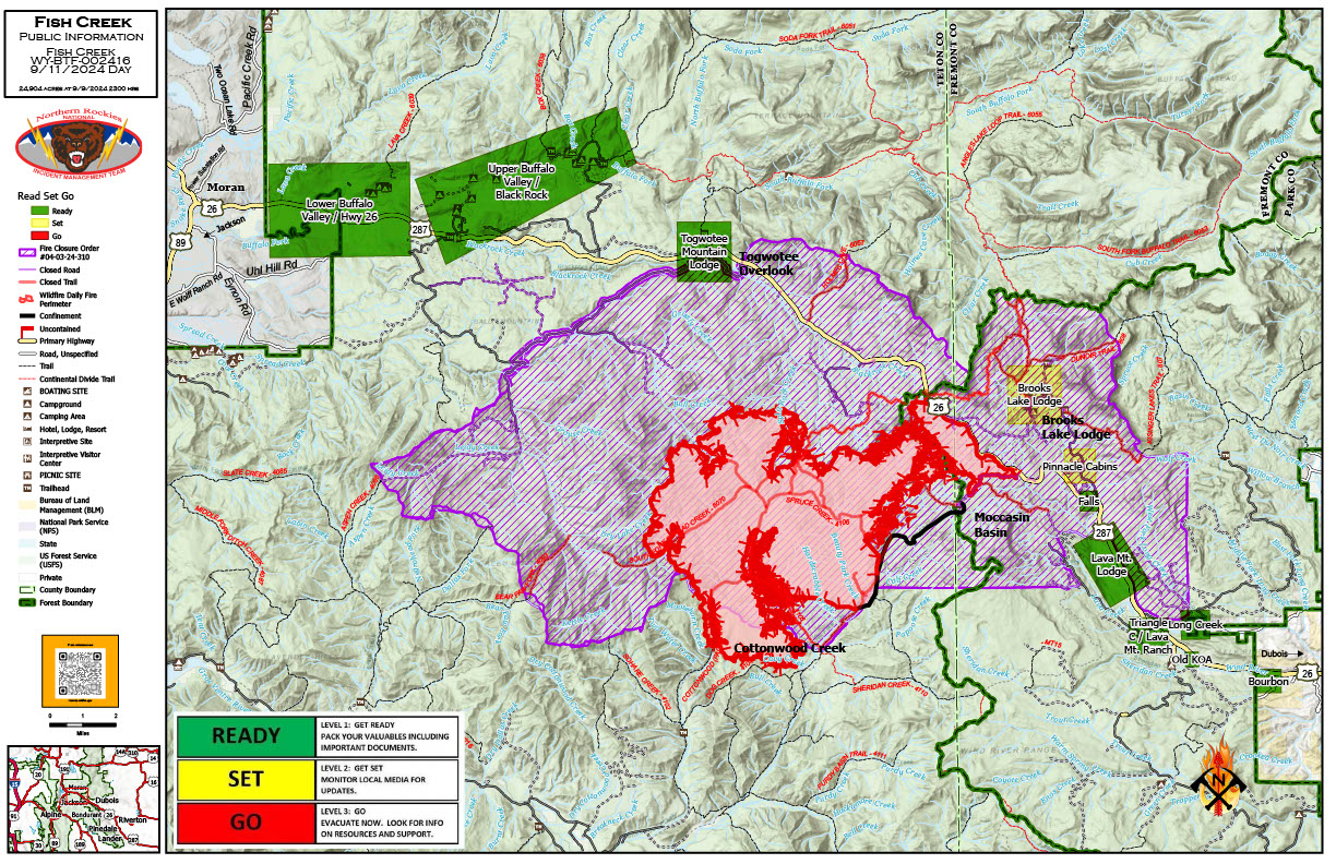
Fish Creek Fire Update Wednesday 09 11 2024
Related Incident:
Publication Type: News
Fish Creek Fire Update Wednesday, September 11, 2024
Northern Rockies Team 2, Incident Commander Scott Schuster
Location: 7 miles SW of Togwotee Pass
Start Date: Friday, August 16, 2024
Cause: Lightning
Size: 24,904
Percent complete: 69%
Resources: 504 Total Personnel: 11 Hand Crews; 24 Engines; 17 Heavy Equipment; 3 Helicopters
KEY MESSAGES:
Air quality has improved with the incoming cold front. Smoke will continue to impact the Highway 26/287 corridor and the immediate area around the fire, including nearby communities and residents. Roadway visibility could be impacted by the smoke from the fire, so please use caution when driving Highway 26/287.
Fremont County has decreased the “GO – Level 3” Evacuation Order to the “SET – Level 2” Notice for the Brooks Lake, Pinnacle, and Breccia areas. Residents are advised to monitor the situation, as there is still the possibility evacuations may once again be ordered if conditions worsen. The Forest Closures are still in place; residents are encouraged to contact the US Forest Service to plan access to their property through the Forest closures.
CURRENT STATUS:
Fire personnel are monitoring fire behavior for any potential threats to Highway 26 and other critical values. They continue to execute mechanical and hand clean-up work along Deception Road from Highway 26 to Brooks Lake Lodge campground. The moderating weather and fire behavior will allow resources to begin shaded fuel-break work on the 2-mile stretch of the Upper Flagstaff Road. This work will include clearing the understory vegetation and smaller trees for 100’ on each side of the road. Firewise work has begun around the Togwotee Lodge to ensure better fire protection from the Fish Creek Fire or future wildfires.
Structure protection work was conducted for the Wyoming Fish and Game cabin and outbuildings in the southern portion of the fire, leaving the buildings wrapped in fire resistant material. The Cottonwood Creek area continues to generate the largest fire growth and greatest fire behavior.
WEATHER AND FIRE BEHAVIOR:
Scattered showers and thunderstorms moved into the area this afternoon. Outflow winds from the thunderstorms were gusty and erratic. The peak day for rainfall, with rainfall amounts up to 0.5 inch expected, is Thursday. A cold front will make its way through the area, dropping temperatures for Thursday and Friday, with freezing temperatures possible both Thursday and Friday nights. The moderating weather conditions will reduce active fire behavior.
AIR QUALITY AND SMOKE:
Unhealthy air quality is possible in locations, especially in low-lying drainages and along the Highway 26/287 corridor. For up-to-date air quality alerts, current and predicted smoke conditions and ways to mitigate poor air quality, check out the AirNow website at https://www.airnow.gov/.
CLOSURES AND EVACUATIONS:
The joint Closure Order issued by both the Bridger-Teton and Shoshone National Forests for the fire area, remains in effect. Please do not enter the closure area or use any Forest Roads that are closed. For specific details regarding this closure, please reference the Fish Creek Area, Roads, and Trails Closure Order (map) and the Forest website at https://www.fs.usda.gov/alerts/btnf/alerts-notices.
Under the jurisdiction of Fremont County, the areas of Brooks Lake, Pinnacle Drive and Breccia Drive have decreased to Level 2 “Set” Notice (indicated by yellow blocks on the PIO Incident Map). A Level 2 “Set” Notice means residents should be ready to evacuate at a moment’s notice. If the Level 2 Set notice changes back to a Level 3 “Go” notice, residents must evacuate until advised otherwise by Fremont County. See the alert notice on the Fremont County Fire Protection District Facebook page.
The Teton County Division of Emergency Management utilizes a Ready, Set, Go system for evacuation messaging, visit their website for additional details at https://www.tetoncountywy.gov/1846/Ready-Set-GO. (Indicated by green blocks on the PIO Incident Map.) They advise all residents to be in a “Ready” status by preparing for evacuations and becoming fire adapted.
US HWY 26/287 is open for free-flowing traffic, but motorists may still experience smoke and sometimes limited visibility. A 45-mph speed restriction remains in effect for the fire area. Motorists are encouraged to stay alert for fire personnel and fire vehicles and use caution when travelling through the area. The Wyoming Department of Transportation (WYDOT) continues to work closely with Fremont County Emergency Management, Fremont County Sheriff’s Office and fire officials for the safety of motorists and firefighters. Drivers are encouraged to visit https://www.wyoroad.info/ prior to traveling on US HWY 26/287 for road status and information, or download the Wyoming 511 app at https://www.wyoroad.info/511/WY511Mobile.html to monitor for any changes due to fire activity.
Fire Summary September 9 09 09 2024
Related Incident:
Publication Type: News
There have been three (3) new fires reported on the Salmon-Challis National Forest since the last update on Tuesday, September 3, 2024. To date, there have been 50 wildfires reported on the Salmon-Challis National Forest. 39 of the fires have been declared out.
Duck (September 3): is located approximately five (5) miles southwest of Yellowjacket Guard Station. The 0.10 acre fire is out.
Shell (September 3): is located approximately 28 miles northwest of Challis on the Middle Fork Ranger District in the Frank Church River of No Return Wilderness. The fire remains at 0.10 acre and is burning in fir.
Wheat (September 3): is located approximately 32 miles west of North Fork on the North Fork Ranger District. The 0.10 acre fire is out.
Moyer (September 3) is located approximately 25 miles southwest of Salmon on the Salmon-Cobalt Ranger District. The 0.10 acre fire is out.
Kinnikinic (September 3): is located approximately 13 miles southwest of Challis on the Challis-Yankee Fork Ranger District. The 0.10 acre fire is out.
Vanity (September 3): is located approximately 42 miles west of Challis on the Middle Fork Ranger District. The 500 acre fire is burning in subalpine fir and is surrounded by the 2012 Halstead Fire. Fire managers are using a point protection strategy (a wildfire response strategy, which protects specific assets or highly valued resources from the wildfire without directly halting the continued spread of the wildfire) to minimize exposure to fire personnel while protecting identified values. Specific values potentially threatened with this fire include Forest Service infrastructure. 25 firefighters are assigned to the fire. The Beaver Creek Road #008 is closed for public safety due to the Vanity Fire. The closure can be found at: https://www.fs.usda.gov/Internet/FSE_DOCUMENTS/fseprd1203351.pdf.
Silver (September 2): is located approximately 35 miles southwest of Salmon on the Salmon-Cobalt Ranger District. The 0.25 acre fire which is 100% contained and controlled.
Phelan (September 2): is located west of the Ridge Road #020 approximately nine (9) miles west of Salmon on the Salmon-Cobalt Ranger District. The fire is estimated at three (3) acres burning in lodgepole pine and is out.
Red Rock (September 2): is located approximately two (2) miles east of Yellowjacket Guard Station on the Salmon-Cobalt Ranger District. A Type III Incident Management Team is managing the fire and information is being reported separately. The fire can be found on InciWeb at https://inciweb.wildfire.gov/incident-information/idscf-red-rock-fire.
Reynolds (August 22): is located approximately 21 miles northwest of Indianola, approximately 5.5 miles northwest of Horse Creek Hot Springs Campground on the Idaho/Montana border. Fire is estimated to be approximately 2,030 acres burning in spruce and fir. The Bitterroot National Forest is lead on this fire.
Birch (August 17): is located on the west side of the Middle Fork of the Salmon River on Norton Ridge on the Middle Fork Ranger District in the Frank Church River of No Return Wilderness. The 202 acre fire is burning in subalpine fir. The fire is surrounded by the 2022 Norton Fire and fire scars from the fires of 2000.
Greyhound (August 11): is located approximately 46 miles northwest of Challis on the Middle Fork Ranger District. The 45 acre fire is burning in subalpine fir and lodgepole pine. The fire is backing down until Sulphur Creek at the edge 2021 Boundary Creek Fire. Firefighter and public safety is the number one priority for the Greyhound Fire. During initial size up for the fire, several safety concerns were identified including: the remote location of the fire, steep and inaccessible terrain, heavy dead and down fuels with a substantial snag component, private property and associated mining infrastructure, and lack of safe ingress and egress for firefighters. Fire managers will be monitoring the fire with reconnaissance flights and lookouts. NFS Road #011 is a one way in, one way out roadway and is is closed for public safety, closure can be found at https://www.fs.usda.gov/Internet/FSE_DOCUMENTS/fseprd1201939.pdf.
Black Eagle (August 5): is located approximately 12 miles west of Forney on the North Fork Ranger District in the Frank Church River of No Return Wilderness. The fire is burning in lodgepole and subalpine fir. A Type III Incident Management Team is managing the fire and information is being reported separately. The fire can be found on InciWeb at https://inciweb.wildfire.gov/incident-information/idscf-black-eagle-fire.
Wapiti (July 24): started on the Boise National Forest, burned onto the Sawtooth National, and around August 24th burned onto the Salmon-Challis National Forest. A Complex Incident Management Team is managing the fire. Information can be found on InciWeb at https://inciweb.wildfire.gov/incident-information/idbof-wapiti-fire.
Deer (July 25): The lightning fire is located approximately 33 miles northwest of Challis, southeast of Pinyon Peak on the Middle Fork Ranger District in the Frank Church River of No Return Wilderness. Loon Creek Guard Station is east of the fire. The fire, burning in grass and conifers is estimated at approximately 54 acres. The fire is burning on both side of Rabbit Creek, in the 2006 Trail Creek Fire. Fire managers are using a point protection strategy (a wildfire response strategy, which protects specific assets or highly valued resources from the wildfire without directly halting the continued spread of the wildfire) to minimize exposure to fire personnel while protecting identified values. The strategy takes into account exposure to firefighters, values at risk, and wilderness values. Specific values potentially threatened with this fire include private land and Forest Service infrastructure.
Thunder (July 24): The lightning fire is located approximately two (2) miles northwest of Williams Lake and approximately 12 miles southwest of Salmon. The fire is 100% contained and controlled, fire size is estimated to be 2,474 acres and is burning in timber, sagebrush, and grass.
Weather: A period of cooler weather is expected to hit the area Wednesday through Friday with isolated thunderstorms. These storms are not predicted to bring significant moisture to the area but will be accompanied by wind gusts of up to 35 miles per hour.
The forest is asking visitors to be aware of the fire danger for the Salmon-Challis National Forest. Ensure your campfire is dead out. If it is too hot to touch, it is too hot to leave! One Less Spark Means One Less Wildfire. Since June 1, Forest employees have found and extinguished at least 13 abandoned campfires.
Nationally, there are 67 uncontained large fires being managed under a full suppression strategy and 28 large fires managed under a strategy other than full suppression.
Visit our website at: www.fs.usda.gov/scnf/, ‘Like Us’ on Facebook @salmonchallisnf, and ‘Follow Us’ on X @salmonchallisnf.
####
Bridge Fire Evening Update 09 10 2024
Related Incident: Bridge Fire
Publication Type: News
Unified Command: CIIMT5, Los Angeles County Fire, Los Angeles County Sheriff, San Bernardino County Fire, CAL FIRE – San Bernardino/Inyo/Mono Unit
Fire Size: 34,240 acres
Percent Contained: 0%
Personnel: 471
Cause: Under investigation
Start Date: Sunday, September 8, 2024, at 2:12 p.m.
CURRENT SITUATION: Today, the Bridge Fire exhibited extreme fire behavior and spread north and northeast, towards the communities of Wrightwood and Pinon Hills. New evacuation orders were issued by the San Bernardino County Sheriff’s Department starting at approximately 4:57 p.m. for these communities. CAL FIRE – San Bernardino/Inyo/Mono Unit entered into Unified Command this afternoon.
Structural protection and defense groups have been placed in the communities of Wrightwood and Mount Baldy, with more of these resources on order. Top priorities for suppression efforts remain on the north and east sides of the fire to protect communities and critical communication and power infrastructure. At this time, we cannot confirm damage to structures. Once it is safe for damage assessment teams to evaluate, information will be released.
Evacuation Orders:
- Pinon Hills from Wrightwood north to Highway 18 and Beekley Road west to Los Angeles County
- Lone Pine Canyon from the community of Wrightwood to Hwy. 138/Lone Pine Canyon Road south to the forest
- Entire community of Wrightwood
- East Fork communities of Camp Williams Resort (café, mobile home park, campground) and River Community (near the resort)
- Mt. Baldy Road, all residents north of the San Antonio Dam up to the Mt. Baldy Resort
Evacuation Warnings:
- San Antonio Heights and Upland from the foothills south to the I-210
- Pinon Hills from Wrightwood north to Hwy. 138 and Lebec Road west to Los Angeles County
Evacuation Centers:
- San Bernardino County Fairgrounds: 14800 Seventh Street, Victorville, CA 92392
- Jessie Turner Health and Fitness Community Center: 15556 Summit Ave, Fontana, CA 92336. Call (909) 854-5100 (can bring small animals in the company of owners).
- Pomona Fairplex: 601 W McKinley Avenue Pomona, CA 91768 (Enter Gate 3, corner of McKinley and White)
- Animals:
- Devore Animal Shelter (pets/livestock): 19777 Shelter Way, San Bernardino, CA 92407. Call (909) 386-9820, or after hours: (800) 472-5609.
- Palmdale Animal Care Center (small animals): 38550 Sierra Hwy, Palmdale, CA 93550
- Lancaster Animal Care Center (small animals): 5210 W. Avenue I, Lancaster, CA 93536
- Antelope Valley Fairgrounds (large animals): 2551 W. Avenue H, Lancaster, CA 93536. Call 562-706-8581 prior to arrival.
For more information on evacuation centers, visit:
- www.redcross.org/get-help/disaster-relief-and-recovery-services/find-an-open-shelter.html
- https://lacounty.gov/emergency/
- https://prepare.sbcounty.gov/line-fire
CLOSURES:
- State Route 138 from Lone Pine to Beekley Road
- State Route 2 closed from Big Pine to SR-138
- San Gabriel Canyon and East Fork of the San Gabriel River
- State Route 39
- East Fork Road
- Glendora Ridge Road
- Glendora Mountain Road
- Mt. Baldy Road at Shinn Road intersection
WEATHER: Excessive heat and Red Flag Warning until Wednesday afternoon due to hot, dry, and unstable conditions with gusty onshore winds. Winds will shift to the west and northwest on Wednesday, which may impact higher elevation areas. Temperatures will remain high, however humidity will improve and increase slightly. Large vertical plume growth and visible smoke columns will be expected again for this fire. For information on smoke impacts and an interactive map, visit fire.airnow.gov.
Alexander Mountain Fire Burned Area Summary Report09 11 2024
Related Incident:
Publication Type: News
The Alexander Mountain post-fire BAER team has completed their burned area assessment report for the Roosevelt National Forest (attached below). The Burned Area Emergency Response (BAER) assessment represents one part of the greater collaborative post-wildfire recovery efforts that occur with a coalition of local, state and federal agencies, scientists and natural resource managers after some fires. BAER teams focus solely on National Forest lands and values at risk in the immediate aftermath of an incident.
The Alexander Mountain Fire summary report found limited risks to human life and safety, infrastructure, natural and cultural resources on Forest Service lands within the burn area. The report found increased risk for flooding and debris flows following heavy rainstorms, primarily due to steep slopes throughout the burned area. This risk is pertinent not only for Forest Service lands but also for values downstream of the Roosevelt National Forest. The BAER team is therefore working closely with Larimer County Office of Emergency Management (OEM), the agency leading the Larimer Recovery Collaborative, on their post-fire emergency response work.
Everyone near and downstream from the burned area should remain alert and stay updated on weather conditions that may result in heavy rains over the burn scar. Flash flooding may occur quickly during heavy rain events. Larimer County has a website with recovery resources for residents impacted by the Alexander Mountain Fire. Other flood preparedness information is available at www.ready.gov/floods and www.floodsmart.gov.
The Arapaho and Roosevelt National Forests and Pawnee National Grassland will continue to work and participate in interagency efforts address threats to public and private recovery needs following the fire.