
Devils Knob and Milepost 98 Fire Update 09 17 2024
Related Incident:
Publication Type: News
Devil’s Knob and Milepost 98 Fire Update for Tuesday, September 17, 2024
KEY MESSAGES:
All primary objectives on the Milepost 98 Fire have been met, including protection of the town of Canyonville, the local watershed, powerlines, and a communications tower. Yesterday, command of the incident on the Milepost 98 Fire was transferred back to the Douglas Forest Protective Association.
CURRENT STATUS:
Incident personnel on the Devil’s Knob Fire are beginning to demobilize as work is completed. As of this morning, the entire western flank of the Devil’s Knob fire is contained. Suppression repair work is focused on the northern edge of the fire, with mop-up continuing on the east side. Grading work is ongoing on the lower portion of the 1610 Road, and culverts were replaced on the 300 Road to return the area to Forest standard following firefighting activities. Tethering operations continue bolstering lines on the south side in the Flat Creek drainage.
WEATHER / FIRE BEHAVIOR:
There was no precipitation on the fire yesterday though fog accumulated in the upper elevations on the east flank of the perimeter. A new storm system is expected to rotate into the area today, transitioning from a dry morning to rain in the afternoon which could linger into Wednesday. Temperatures will be cool, in the high 50s to low 60s, while relative humidity will remain high for most of the week.
SAFETY AND CLOSURES:
Closures on the Umpqua National Forest can be found at https://www.fs.usda.gov/alerts/umpqua/alerts-notices.
Umpqua National Forest restrictions can be found at https://www.fs.usda.gov/main/umpqua/fire.
Fire Restrictions for Bureau of Land Management can be found on the Oregon-Washington blm.gov page.
Douglas Forest Protective Association restrictions can be found at https://www.dfpa.net/public-fire-restrictions.
Oregon Dept. of Forestry restrictions can be found at https://www.oregon.gov/odf/fire/pages/restrictions.aspx.
Bridge Fire Morning Update 09 17 2024
Related Incident: Bridge Fire
Publication Type: News
Unified Command: CIIMT5, Los Angeles County Fire, Los Angeles County Sheriff, San Bernardino County Fire, San Bernardino County Sheriff, CAL FIRE – San Bernardino/Inyo/Mono Unit
Start Date: September 8, 2024, at 2:12 p.m.
Fire Information: (626) 662-0120 ***Original number***
Media Line: (626) 470-1395
Hours: 7:00 a.m. to 9:00 p.m.
Email: 2024.Bridge@firenet.gov
Fire Size: 54,795 acres
Percent Contained: 25%
Personnel: 2,727
Injuries: 3
Structures Damaged: 13
Structures Destroyed: 66
Cause: Under investigation
Location: Sheep Mountain Wilderness, San Gabriel Mountains National Monument
CURRENT SITUATION: Firefighters made significant progress last night with much colder temperatures, higher humidity, and minimal growth. In all areas of the fire, crews will prioritize securing and validating containment lines today to further increase the containment percentage and get residents back into their homes where hazards have been cleared. Strike teams of engines and hand crews, water tenders, and falling modules have been ordered to continue assisting fire personnel, along with air resources that have continued to support boots on the ground.
Today’s priority is in the fire’s northwest corner, which remains the most active. A smoldering tree fell and rolled across the line overnight, leading to a 1-acre slop-over on Fenner Saddle Road. Crews contained the fire spread and will work to line it today. The Big Pines corridor/Fenner Gap area still has challenges, but with the favorable weather today, crews are making progress containing fireline and mopping up around structures while being assisted by aircraft strategically dropping water and retardant.
In the Wrightwood area, safety hazards remain while firefighters continue mop-up operations and falling trees. Residents remain under an evacuation order until these hazards are cleared for the public and utilities are restored.
To the northeast, firefighters are working to prevent the fire from advancing from Wright Mountain towards the community of Lytle Creek by constructing dozer lines and engaging in direct attack wherever possible.
The fire's east flank is holding well, and safety hazards are being cleared so residents can repopulate the Mt. Baldy area. Today, hotshot crews are being prioritized to accomplish this mission.
The south side of the fire is also holding well, where firefighters are beginning the suppression repair process in areas with full containment and there is no further threat to the line. Additional containment will likely increase as firefighters prioritize validating their work in this area. There are still some heat signatures around the Sunset Peak area, and crews will continue working to extinguish them.
On the west flank, firefighters are constructing indirect fireline and will seek out hot spots with the assistance of aircraft and infrared imaging in this extremely steep and inaccessible terrain of the Sheep Mountain Wilderness.
Damage inspection teams continue to update interactive maps for residents affected by the Bridge Fire.
For San Bernardino County: prepare.sbcounty.gov/bridge-fire/
For Los Angeles County: recovery.lacounty.gov/bridgefire/
Evacuation Orders:
- Mt. Baldy Road, all residents north of San Antonio Dam up to Mount Baldy Ski Resort
- The community of Wrightwood
- Big Pines Canyon Road to the community of Big Pines
- East Fork communities of Camp Williams Resort (café, mobile home park, campground) and River Community (near the resort)
Evacuation Warnings:
- Forest area of Telegraph Peak east to the Cucamonga Canyon and forestry area above Shinn Road and North Pine Canyon Road
- The southern community of Pinon Hills from Desert Front Road north to Highway 138 and State Highway west
- Highway 138 south to Lone Pine Canyon and Highway 2 east to Lone Pine Canyon Road
- For evacuation warnings in San Dimas, La Verne, and Claremont please visit: Genasys Protect
For an interactive map on evacuations, please visit:
Los Angeles County: Genasys Protect website or download the app. https://protect.genasys.com
San Bernadino: https://sbcounty.maps.arcgis.com
For emergency alerts, please register here:
Los Angeles County: https://ready.lacounty.gov/emergency-notifications/
San Bernardino County: https://wp.sbcounty.gov/sheriff/alerts/
Evacuation Centers:
- Fountain of Living Waters Church: 10120 Johnson Rd, Phelan, CA 92371
- San Bernardino County Fairgrounds: 14800 Seventh Street, Victorville, CA
- Jessie Turner Health/Fitness Center: 15556 Summit Ave, Fontana, CA. (909) 854-5100
- Pomona Fairplex: 601 W McKinley Avenue Pomona, CA (Gate 3, corner of McKinley/White)
Animals:
- Devore Animal Shelter: 19777 Shelter Way, San Bernardino, CA. (909) 386-9820. After hours: (800) 472-5609
- San Bernardino County Fairgrounds: 14800 Seventh Street, Victorville, CA
- Palmdale Animal Care Center (Small Animals): 38550 Sierra Hwy, Palmdale, CA
- Lancaster Animal Care Center (Small Animals): 5210 W Ave I, Lancaster, CA
For more information on evacuation centers;
- www.redcross.org/get-help/disaster-relief-and-recovery-services/find-an-open-shelter.html
- https://lacounty.gov/emergency/
CLOSURES:
- SR-138 from Lone Pine Canyon Road to Beekley Road
- SR-2 closed from Big Pines to SR-138
- Big Pines Highway
- Big Rock Creek Road
- San Gabriel Canyon and East Fork of the San Gabriel River
- Highway 39
- East Fork Road
- Glendora Ridge Road and Glendora Mountain Road
- Mt. Baldy Road at Shinn Road intersection
WEATHER:
There are minimal fire weather concerns for today. Generally favorable winds, temperatures, and humidity will continue through Thursday, however hot and dry conditions are expected to resume again Friday.
For smoke impacts and an interactive map, visit fire.airnow.gov.
FIRE RESTRICTIONS IN OPEN AREAS OF ANGELES NATIONAL FOREST:
Fire danger on the Angeles National Forest is now “Extreme” Angeles National Forest - News & Events (usda.gov)
Short Draw Fire Daily Update 09 17 2024
Related Incident:
Publication Type: News
Key Messages
The Montana DNRC County Assist Team and local agencies have been connecting with affected landowners to provide available resources. For information on post-fire relief, please visit: https://www.uwyo.edu/barnbackyard/resources/wildfire.html.
Current Status
Fireline has been successfully established along the east, north, and west perimeters of the fire, with a few remaining sections expected to turn black by the end of today. Crews are concentrating efforts on the south end, working to secure a solid control line. Mopping up and suppression efforts are ongoing, with teams working to extend control line efforts 200 feet into the fire area. North of 3 Bar Road, a significant unburned section of forest remains under close observation, with crews actively monitoring to ensure it doesn’t ignite. Coal seams within the fire perimeter are being closely monitored and mapped as these underground deposits can smolder for extended periods and pose a risk for flare-ups. Meanwhile, excavators, dozers and road graders have begun repairing and rehabilitating previously constructed dozer contingency lines across the fire area to mitigate further impact and to restore the landscape.
Weather and Fire Behavior
Tuesday’s weather is mostly sunny, becoming cloudy in the afternoon with temperatures in the mid to high 80s. South winds increasing to 15-20 mph with gusts up to 35 mph in the afternoon. A 55% chance of showers and thunderstorms in the afternoon. Gusty and erratic winds expected near thunderstorms in the afternoon.
Evacuations And Closures
All evacuation warnings and notices associated with the fire area have been rescinded. Please avoid the fire area as crews and aerial resources continue fire suppression efforts. The roads remain closed to non-local traffic. Ensuring firefighter safety and protecting life and preservation of grazing lands are most important.
There is a temporary flight restriction (TFR) over the fire area. For firefighter safety, please do not fly unmanned aerial systems in the area.
Middle Fork Complex Daily Update September 17 2024 09 17 2024
Related Incident:
Publication Type: News
Middle Fork Complex Fire Update
Tuesday September 17, 2024
Thunderstorms and Rain to Persist Over the Fire
The Middle Fork Complex is 61,482 acres with 32% completion. Thunderstorms will continue to persist in the area through the afternoon. At least half an inch of rain fell across the fire area yesterday, with over an inch in other places. Several debris slides continue to occur on the forest roads, including the 678 and 555 roads. Due to ongoing weather, more debris slides are likely throughout the burn area and crews must wait until conditions improve and roadways dry to begin assessing and repairing roads. Safety for firefighters is the number one priority as road conditions change. There are currently 546 resources assigned to the incident.
A new start was reported approximately four miles northwest of Deadwood Reservoir in the Rabbit Creek area. A second start was reported southwest of the 555 Road. If conditions allow, a fly over is planned for today to assess the fires. Firefighters are prepared to respond to any additional new starts in the area.
Fire activity remained minimal yesterday and some moderate growth was seen in the fire area in the afternoon as temperatures began to rise, fuels dried, and winds increased ahead of the storms. After the storms arrived, fire activity decreased and is expected to remain low in the coming days. The fire continues to smolder and creep through the heavy fuels in areas that are protected from the rain.
Great Basin Team 2 is shadowing Great Basin Team 5 today and will be transitioning command tomorrow morning.
Boise National Forest Closure Order Number 0402-06-64 remains in effect. An interactive forest closure map is available on the Boise National Forest Alerts & Closures website, https://www.fs.usda.gov/alerts/boise/alerts-notices.
Hunters are not allowed access to these closed areas.
Highway 21 is closed from the Sourdough Lodge in Lowman to Stanley Lake Road (MP 84 to 126) due to nearby wildfire activity. Only local traffic is allowed between the Sourdough Lodge and Warm Springs Airstrip. There is no public access from the highway to surrounding areas including Grandjean, Bull Trout, Boundary Creek, Cape Horn, or Seafoam. For more information, visit the Idaho Department of Transportation website, https://511.idaho.gov/
Take wildfire risk reduction steps to make your home safer during a wildfire: Visit the Firewise website for information: https://www.nfpa.org/en/Education-and-Research/Wildfire/Preparing-homes-for-wildfire
Wildfires are a No Drone Zone. If you fly, we can’t. Every time a drone is spotted near the fire all aircraft are grounded until we can be sure the drone is clear of this area. Visit Know Before You Fly, http://knowbeforeyoufly.org. A Temporary Flight Restriction (TFR) is in effect in the fire area.
Fire Information: 208-992-3045 (8am – 8pm) Email: 2024.middleforkcomplex@firenet.gov
Inciweb: https://inciweb.wildfire.gov/incident-information/idbof-middle-fork-complex-fire-bulldog-and-nellie
Facebook: https://www.facebook.com/people/Middle-Fork-Complex-Fire-Boise-National-Forest/61565022204468
Rail Ridge Fire Update September 17 2024 09 17 2024
Related Incident:
Publication Type: News
Rail Ridge QuickFacts
Acres: 162,278
Crews: 23
Containment: 38%
Detection Date: Sept 2, 2024
Cause: Lightning
Engines: 90
Dozers: 25
Helicopters: 2 Type 1, 1 Type 2, 1 Type 3
Total resources: 1,168
Phone: 541-208-7111 Email: 2024.railridge@firenet.gov Facebook: Rail Ridge Fire - Oregon 2024
Inciweb: https://inciweb.wildfire.gov/incident-information/orocf-rail-ridge
LinkTree: https://linktr.ee/RailRidgeFire
Closures and Evacuations
Closures: The U.S. Forest Service and Bureau of Land Management have implemented partial closures because of the Rail Ridge and Crazy Creek fires, for all uses. For more details and closure maps, visit the Ochoco National Forest, Malheur National Forest, and BLM web pages.
Evacuations: Evacuations north of U.S. 26 in Grant County were lifted and the shelter in John Day has been closed. For up-to-date evacuation information, please visit:
- Grant County: Emergency Management Facebook page.
- Crook County: Emergency Management website; Sheriff’s Office Facebook page.
- Wheeler County: Sheriff’s Office Facebook page.
Operational Update
Favorable conditions, including as much as 0.25 inches of rain fell on some parts of the fire, further reduced fire activity in the area last night. This trend is expected to continue today as the crews continue to work on line construction, improving existing lines and conducting mopup operations.
Along the north and west lines of the fire, crews will look for safe opportunities to construct direct line, as well as improve all established control lines. Crews will focus on improving the shaded fuel break around the Black Canyon Wilderness.
On the east edge of the fire, crews are taking a direct-attack approach west of Fields Peak south to Thorn Creek Butte.
Crews will continue to monitor and patrol the southern portion of the fire and begin suppression repair.
Weather
Cool weather and forecasted precipitation and higher humidity will provide favorable conditions for crews today and through the rest of the week. Some smoky conditions are anticipated in warmer and dryer areas, and fire will continue to smolder and creep in some areas of pine/timber litter.
Cool and cloudy conditions are expected throughout the region, with isolated showers possible in the morning and afternoon. Breezy northwesterly winds are expected through the evening with gusts up to 25 mph.
Davis Fire Update09 17 2024
Related Incident: Davis Fire
Publication Type: News
Acres: 5,824 acres
Start Date: 09/07/2024
Location: Washoe Valley, Nevada
Personnel: 492
Containment: 92%
Fuels: Timber
Resources: 10 Crews | 3 Helicopters | 27 Engines | 3 Water Tenders | 2 Dozers
Highlights: Firefighters made incredible progress on the fire yesterday, increasing containment to 92%. Today, fire personnel are splitting efforts between patrolling fire activity and repairing affected area. There are no active suppression efforts or mop up occurring at this time. Due to the increase in containment, some fire resources are being reassigned to other wildfire incidents, so we will begin to see a drop in number of personnel. Please continue to travel with caution near affected areas for the safety of the public and the firefighters still working in the area.
Weather: There is a 10% chance of rain today as a new storm system approaches, with expectations of a 70% chance of rain tomorrow. The average max temperature will be 64 degrees, with high relative humidity that persists throughout the day. Expect winds of 9mph with gusts up to 18mph. Rain yesterday assisted by diminishing fire behavior, limiting any smoldering occurring on the fire.
BAER: A Burned Area Emergency Response (BAER) team has been established by the Humboldt-Toiyabe National Forest to begin a post-fire burned area assessment of National Forest System lands that burned in the Davis Fire. BAER teams coordinate with the Natural Resources Conservation Service, National Weather Service, U.S. Geological Survey, Bureau of Land Management, and other federal, state, counties, and local agencies as they assess potential post-fire impacts to the effected watersheds. To learn more about BAER, visit https://www.fs.usda.gov/naturalresources/watershed/burnedareas.shtml
Fire Investigation: Truckee Meadows Fire Protection District and the Washoe County Sheriff’s Office are leading the investigation into the cause of the Davis Fire. If you have credible information, or if you were in the vicinity of the day-use area at Davis Creek Regional Park on September 8th at the start of the fire, contact 775-326-6079 or email: info@tmfpd.us.
Evacuations: For updates on evacuation statuses please visit: https://perimetermap.com. To sign up for future evacuation alerts and warnings, visit https://www.washoecounty.gov/em/RegionalAlerts.php
Closures: Forest area closures remain in effect for the area immediately in and around the Davis Fire burned area. For complete details on the Davis Fire Emergency Closure Order, https://www.fs.usda.gov/alerts/htnf/alerts-notices/?aid=90526
Willamette Complex South Daily Update for September 17 2024 09 17 2024
Related Incident: Willamette Complex Fires - South
Publication Type: News
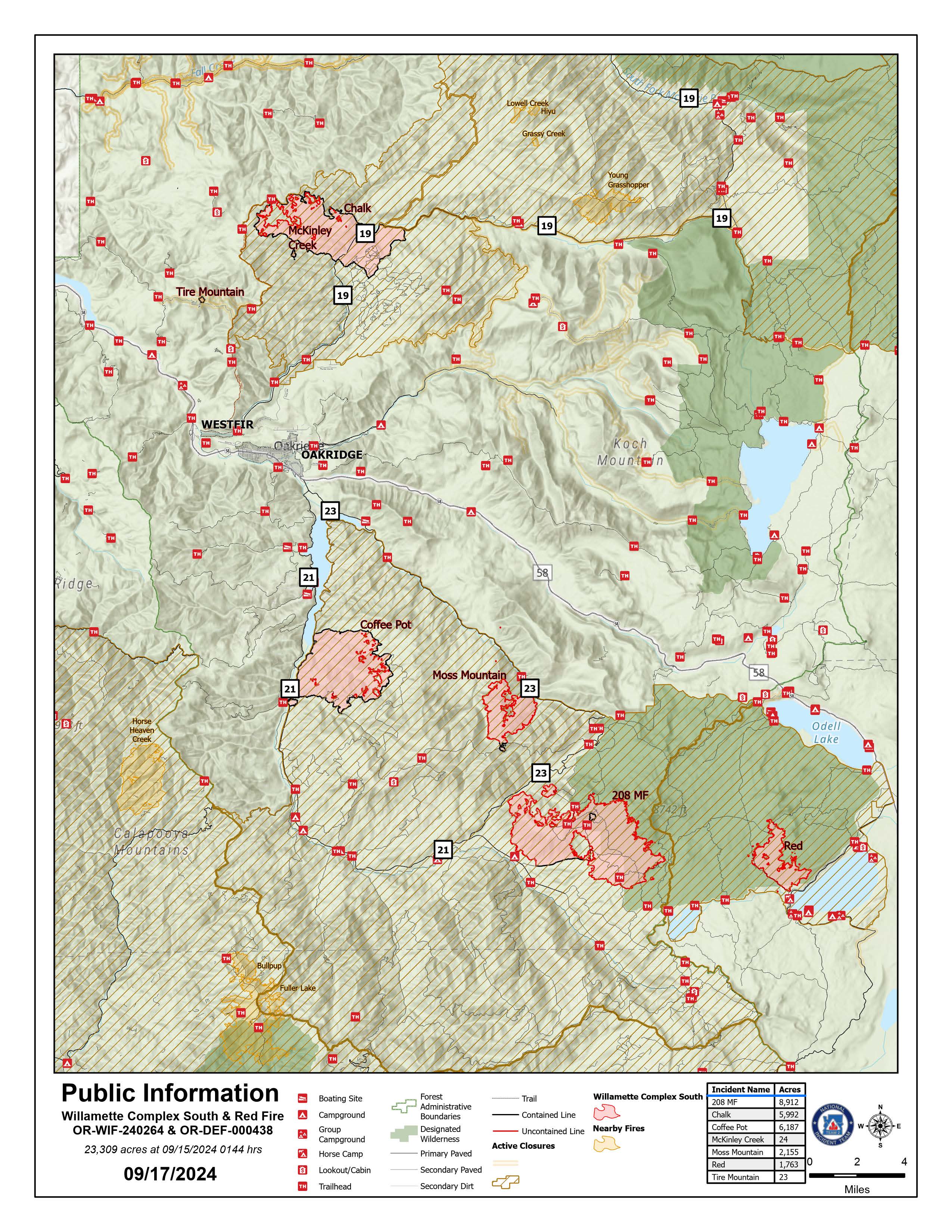
Willamette Complex South & Red Fire Update
Red, 208, Moss Mountain, Coffee Pot, Tire Mountain, McKinley Creek and Chalk Fires
Date: Tuesday, September 17, 2024 Fire Causes: Lightning
Email: 2024.willamettecomplex@firenet.gov Information Phone Line: 541-208-1742
Willamette Complex South: Total Personnel: 519 | Total Willamette Complex South Acres: 23,309
InciWeb: https://inciweb.wildfire.gov/incident-information/orwif-willamette-complex-fires-south
Facebook: https://www.facebook.com/WillametteComplexFires/
Red Fire: Total Personnel: 26 | Total Red Fire Acres: 1,763
InciWeb: https://inciweb.wildfire.gov/incident-information/ordef-red-fire
Facebook: https://www.facebook.com/2024RedFireOR/
Summary
Fire behavior remains minimal across the area. The predominant observable behavior is creeping and smoldering. However, in areas with sun exposure, open, backing flames could persist. Across the multiple fires, work continues on indirect firelines and the repair of resources impacted during suppression efforts.
For fires without full containment, the growth is primarily within the existing footprints. Crews are reinforcing indirect firelines to protect priority resources if fire behavior increases. When using indirect line for suppression, achievement of full containment may only occur in areas where fire reaches the indirect lines or where firing operations off the indirect lines connect to the fire’s perimeter. Because growth remains unlikely, there are no planned firing operations to fill unburned sections between the fireline and the fire perimeter. These fires will creep and smolder until a substantial precipitation event occurs in the area. Firefighters continue to monitor for changes in fire behavior and take appropriate action to minimize acres burned.
The Chalk Fire, Coffee Pot Fire, McKinley Creek Fire, and Tire Mountain Fire are all 100% contained and in patrol and repair status. Firefighters, in collaboration with resource specialists such as archeologists, fish biologists, and hydrologists, are assessing damage from fire suppression efforts to determine necessary repair work. Repair work includes clearing culverts of debris, resurfacing roads, and chipping and hauling material removed during fireline construction. Miles of roads and numerous repair points have been identified. As crews complete the following work, they will continue to prioritize next step repair items alongside resource advisors.
Red Fire (1,763 acres, 0% containment)
Work to haul and remove slash from Forest Service Road (FSR) 1610 is anticipated to take approximately one more week. Road repair efforts in this area are ongoing. Structure protection, portable tanks, hoses, and pumps will remain in place while fire conditions further moderate.
208 Fire (8,912 acres, 4% containment)
Falling of hazard trees was completed yesterday on FSR 21 and is likely to wrap up on along FSR 2149 in one to two more days. Material chipping will continue for five days on FSR 21 from Emigrant Creek to Emigrant Butte.
Moss Mountain Fire (2,155 acres, 10% containment)
Chipping, mastication, and removal of combustible materials is nearly complete along FSR 23. Crews are progressing south near FSR 2316 and plan to tie into existing fireline to the south along FSR 23 from the 208 Fire.
Weather and Fire Behavior
Yesterday, conditions were mostly cloudy with temperatures in the 60s. Relative humidity remained high and there was a mild, northwestern wind with maximum gusts of 10 mph. Today, a low-pressure system will move into the area with low clouds. The high temperature will be in the 50s and there is a 60 percent chance of rain in the evening. This system, and the moisture it brings, will help to further decrease fire activity.
Closures, Fire Restrictions, and Evacuations
- For closure information, visit: https://tinyurl.com/RedFireClosues2024 & https://tinyurl.com/WillFireClosures2024.
- For fire restrictions, visit: https://tinyurl.com/DesFireRestrictions2024 & https://tinyurl.com/WillFireRestrictions2024.
- The Level 1 – BE READY to Evacuate notice remains in effect for the Red Fire. For more information or to sign up for alerts, visit: www.klamathcounty.org/300/emergency-management.
Red Fire Daily Update for Tuesday September 17 2024 09 17 2024
Related Incident: Red Fire
Publication Type: News
Willamette Complex South & Red Fire Update
Red, 208, Moss Mountain, Coffee Pot, Tire Mountain, McKinley Creek and Chalk Fires
Date: Tuesday, September 17, 2024 Fire Causes: Lightning
Email: 2024.willamettecomplex@firenet.gov Information Phone Line: 541-208-1742
Willamette Complex South: Total Personnel: 519 | Total Willamette Complex South Acres: 23,309
InciWeb: https://inciweb.wildfire.gov/incident-information/orwif-willamette-complex-fires-south
Facebook: https://www.facebook.com/WillametteComplexFires/
Red Fire: Total Personnel: 26 | Total Red Fire Acres: 1,763
InciWeb: https://inciweb.wildfire.gov/incident-information/ordef-red-fire
Facebook: https://www.facebook.com/2024RedFireOR/
Summary
Fire behavior remains minimal across the area. The predominant observable behavior is creeping and smoldering. However, in areas with sun exposure, open, backing flames could persist. Across the multiple fires, work continues on indirect firelines and the repair of resources impacted during suppression efforts.
For fires without full containment, the growth is primarily within the existing footprints. Crews are reinforcing indirect firelines to protect priority resources if fire behavior increases. When using indirect line for suppression, achievement of full containment may only occur in areas where fire reaches the indirect lines or where firing operations off the indirect lines connect to the fire’s perimeter. Because growth remains unlikely, there are no planned firing operations to fill unburned sections between the fireline and the fire perimeter. These fires will creep and smolder until a substantial precipitation event occurs in the area. Firefighters continue to monitor for changes in fire behavior and take appropriate action to minimize acres burned.
The Chalk Fire, Coffee Pot Fire, McKinley Creek Fire, and Tire Mountain Fire are all 100% contained and in patrol and repair status. Firefighters, in collaboration with resource specialists such as archeologists, fish biologists, and hydrologists, are assessing damage from fire suppression efforts to determine necessary repair work. Repair work includes clearing culverts of debris, resurfacing roads, and chipping and hauling material removed during fireline construction. Miles of roads and numerous repair points have been identified. As crews complete the following work, they will continue to prioritize next step repair items alongside resource advisors.
Red Fire (1,763 acres, 0% containment)
Work to haul and remove slash from Forest Service Road (FSR) 1610 is anticipated to take approximately one more week. Road repair efforts in this area are ongoing. Structure protection, portable tanks, hoses, and pumps will remain in place while fire conditions further moderate.
208 Fire (8,912 acres, 4% containment)
Falling of hazard trees was completed yesterday on FSR 21 and is likely to wrap up on along FSR 2149 in one to two more days. Material chipping will continue for five days on FSR 21 from Emigrant Creek to Emigrant Butte.
Moss Mountain Fire (2,155 acres, 10% containment)
Chipping, mastication, and removal of combustible materials is nearly complete along FSR 23. Crews are progressing south near FSR 2316 and plan to tie into existing fireline to the south along FSR 23 from the 208 Fire.
Weather and Fire Behavior
Yesterday, conditions were mostly cloudy with temperatures in the 60s. Relative humidity remained high and there was a mild, northwestern wind with maximum gusts of 10 mph. Today, a low-pressure system will move into the area with low clouds. The high temperature will be in the 50s and there is a 60 percent chance of rain in the evening. This system, and the moisture it brings, will help to further decrease fire activity.
Closures, Fire Restrictions, and Evacuations
- For closure information, visit: https://tinyurl.com/RedFireClosues2024 & https://tinyurl.com/WillFireClosures2024.
- For fire restrictions, visit: https://tinyurl.com/DesFireRestrictions2024 & https://tinyurl.com/WillFireRestrictions2024.
- The Level 1 – BE READY to Evacuate notice remains in effect for the Red Fire. For more information or to sign up for alerts, visit: www.klamathcounty.org/300/emergency-management.
Daily Update for the Frog Fire 09 17 2024
Related Incident: Frog
Publication Type: Announcement
Frog Fire Statistics:
Size: 3,105 acres
Containment: 42%
Total Personnel: 231
Location: Little Boulder Creek off East Fork
Reported: 9/7/2024
Cause: Lightning
For More Information:
Information Phone: 208-510-7856
Email: carlie_swa@firenet.gov
InciWeb: https://inciweb.wildfire.gov/incident-information/idstf-frog Facebook: https://www.facebook.com/sawtoothnationalforest
Current Situation:
Yesterday forecasted winds and light precipitation impacted the fire area in the afternoon during the operational shift. Higher RHs and cloud cover assisted in keeping the fire behavior moderated. Fire behavior consisted of smoldering, creeping, and very intermittent isolated torching along uncontained perimeter and interior pockets.
Division K was monitored and showed no new growth with light smoke interior thanks to crews efforts during previous shifts. Division A remains unstaffed and in monitor status as resources focus efforts near the head of the fire. Fire activity in Division A was moderate as fire slowly backs down slope. Resources have shifted to the head of the fire in Division Z performing checking actions on the fire where they can safely and continuing to construct indirect contingency lines to protect values at risk. Chipping operations continued in Structure South along the east fork road.
Weather permitting crews will continue with current operations today.
Weather, Fuels, and Fire Behavior:
A wet Pacific system will continue to deliver scattered to widespread showers and thunderstorms, bringing wetting rains through Tuesday. Some of the stronger storms may produce heavy rainfall and small hail. Seasonably cool temperatures are expected for the rest of the week, with isolated to scattered precipitation lingering, although conditions will trend drier later in the week.
Evacuations:
For evacuation information on the Frog Fire, please see the Custer County Sheriff’s Facebook page at https://www.facebook.com/p/Custer-County-Sheriff-Idaho-61558947312289/ and the Custer County Emergency Management Facebook page at https://www.facebook.com/ccem.idaho
To sign up for Custer County CodeRED emergency notifications, text CUSTER to 99411 or enroll online at https://public.coderedweb.com/CNE/BF28E45537FF .
Closures and Fire Restrictions:
The Frog Fire Area Closure /Forest Order: 0414-04-152 for portions of the Sawtooth National Forest can be found at this site: https://inciweb.wildfire.gov/incident-publication/idstf-frog/frog-fire-closure-09-10-2024
Fire restrictions on federal, state, and private lands may be found at this site: https://www.idl.idaho.gov/fire-management/fire-restrictions-finder/.
Wildfires are a no-fly zone for unauthorized aircraft, including drones. If you fly, we can’t. For more information, visit http://knowbeforeyoufly.org.
####
West Mountain Fires Daily Closures TFRs Evacuations Information and Important Links 09 17 2024
Related Incident: Dollar Fire
Publication Type: Closures
FOREST CLOSURES
Boise National Forest:
- Closure Order #0402-04-100 Dollar/Oro Area, Trail, and Road Closure – For Forest closure areas over the Dollar fire. For more information visit:
- https://www.fs.usda.gov/Internet/FSE_DOCUMENTS/fseprd1199005.pdf
- https://www.fs.usda.gov/Internet/FSE_DOCUMENTS/fseprd1199004.pdf
- Closure Order #0402-06-64 Anderson-Bulldog-Nellie Fire Area, Road, and Trail Closure – For Forest closure areas over the Goat and Snag Fires. For more information visit:
- https://www.fs.usda.gov/Internet/FSE_DOCUMENTS/fseprd1201350.pdf
- https://www.fs.usda.gov/Internet/FSE_DOCUMENTS/fseprd1201349.pdf
- Closure Order #0402-06-63 Lava Fire Area, Road, and Trail Closure – For Forest closure areas around the Lava and Boulder Fires. For more information visit:
- https://www.fs.usda.gov/Internet/FSE_DOCUMENTS/fseprd1203486.pdf
- https://www.fs.usda.gov/Internet/FSE_DOCUMENTS/fseprd1203488.pdf
Payette National Forest:
- Closure Order #0402-06-63 Lava Fire Area, Road, and Trail Closure – For Forest closure areas around the Lava and Boulder Fires. For more information visit:
- https://www.fs.usda.gov/Internet/FSE_DOCUMENTS/fseprd1203486.pdf
- https://www.fs.usda.gov/Internet/FSE_DOCUMENTS/fseprd1203488.pdf
FIRE RESTRICTIONS
The Boise National Forest is in Stage 1 Fire Restrictions. For more information visit: Boise National Forest.
EVACUATION INFORMATION
Valley County Sheriff’s Office is responsible for issuing and enforcing evacuation orders, and for determining the boundaries of evacuation areas. Fire managers advise the sheriff when management action trigger points are breached.
There are currently READY, SET and GO evacuation orders in place. To stay up to date with the most current information, sign up for emergency alerts, such as evacuation notices by visiting your county’s emergency alert system:
- Valley County: (208) 382-5160 https://www.co.valley.id.us/CompleteEmergencyNotificationandAlerting
- Contact Valley County Dispatch at (208) 382-5160 for information on evacuation shelters
Review the READY, SET, GO evacuation procedure for Valley County: https://www.co.valley.id.us/ReadySetGo
ROAD CLOSURES
- Warm Lake Highway Closure: Warm Lake Rd. Is now fully OPEN to the public. There are no pilot cars or time restrictions. Firefighters are still working in this area; please drive cautiously.
- 409 Rd. from Warm Lake Rd. heading south into the fire area is CLOSED. Please respect this closure; burned area is unsafe.
- National Forest System (NFS) Road 474 is now OPEN from the Boise National Forest boundary to Warm Lake.
TEMPORARY FLIGHT RESTRICTIONS
Temporary Flight Restrictions (TFR) are in place over the Boulder, Dollar, Snag, and Goat Fires. Wildfires are a no- fly zone for unauthorized aircraft, including drones. TFRs are critical for firefighter and aircraft safety. If you fly, we can’t. For more information, visit http://knowbeforeyoufly.org.