
Middle Fork Complex Operational Update September 16 2024 09 16 2024
Related Incident:
Publication Type: Announcement
Wood Lake Fire Update for Monday September 16 2024 09 16 2024
Related Incident:
Publication Type: News
Wood Lake Fire Update
Date: September 16, 2024 Size: 27 acres Containment: 25%
Cause: Under Investigation-Human Caused* Start Date: September 10, 2024
Fire Information:
Inciweb page: https://inciweb.wildfire.gov/incident-information/mnsuf-wood-lake-fire
Closure Information
Superior NF Facebook: https://www.facebook.com/SuperiorNF
Twitter/X: https://x.com/SuperiorNF
Sign up for Superior NF Fire Information notices and news
The fire update will switch to every other day unless there is a change in fire activity.
Current Status and Resources: The fire received little precipitation overnight. Firefighters continue to reinforce the fire’s containment line. Fire activity is minimal, smoldering and burning into the duff layer. Firefighters continue to suppress the fire, monitor containment lines, and use aircraft to cool the fire when conditions warrant. The National Preparedness Level remains at 5.
Planned Actions: The current crew of firefighters will transition tomorrow to a new incident commander. Resources continue to strengthen existing lines on the east and southeast sides utilizing minimum impact strategies and tactics. Additionally, firefighters continue to analyze contingency planning around the Moose Lake area, planning that wider perimeter area around the fire.
Closures: The Superior National Forest will be adjusting the Emergency Closure Order #09-09-24-07 for the public’s health and safety due to the Wood Lake fire within the vicinity of recreation areas. Beginning at 12:01 am, Tuesday, September 17, 2024, the Wind Lake travel corridor lakes and portages will be lifted off the closure. An updated Exhibit A-List of Closed Areas and Exhibit B-Closure map will be released for the closure adjustments. For the safety of firefighting resources, no drones are allowed near the fire area and are illegal in federally designated wilderness areas.
Weather and Smoke: Today-Partly sunny with a high near 80. 40% chance of showers and thunderstorms after 2pm. Calm southern winds around 5mph, gusting up to 15mph with any storms. Overnight-A 40% chance of showers and thunderstorms after 11 pm, otherwise mostly cloudy. Low of 62. South winds around 5 mph. Tuesday- chance of showers and thunderstorms before 1pm, then a slight chance after 1pm. Mostly sunny, high of 79. South wind 5-10mph, gusts of 20mph. Chance of precipitation is 40%.
Overall air quality in the Ely area will be GOOD today. Wildfire smoke from Canada is possible in the area. https://www.airnow.gov/and https://www.pca.state.mn.us/air-water-land-climate/air-quality-forecast
Fire Summary: On September 10, 2024, around 11:00 a.m. a fire was detected on an island of Wood Lake, located north of County Road 18, within the Boundary Waters Canoe Area Wilderness (BWCAW) of the Superior National Forest. The fire is located in T64, R10, S26 on National Forest System land. An Emergency Closure Order is in effect for 19 locations including BWCAW Entry Point 27-Wood Lake.
*Superior NF law enforcement staff are requesting any information into the start of the fire. Please email the Superior NF Tipline at SM.FS.SUP-tipline@usda.gov, Superior NF Webpage Tipline. Thank you for your assistance.
Buck Creek and Bowman Well Fire Update 09 16 2024
Related Incident: Buck Creek Fire
Publication Type: News
Buck Creek Size: 5,647 acres | Reported Date: September 7 | Cause: Lightning | Containment: 10%
Final Report: Bowman Well Size: 2,853 acres | Reported Date: September 6 | Cause: Lightning | Containment: 97%
Total Resources Personnel: 673 | Crews: 17 | Engines: 38| Water Tenders: 19 | Heavy Equipment: 15 | Helicopters: 4
(Silver Lake, Ore.) – The Buck Creek Fire started in heavy timber within the Yamsay Mountain Semi-Primitive Area on the Fremont-Winema National Forest, about 13 miles southwest of Silver Lake, Ore. The fire spread north and east into managed timber stands with brush and grass understory and is now about 11 miles from the community of Silver Lake. The Bowman Well Fire was burning in sage brush, grass, and juniper on lands administered by the Bureau of Land Management about 3 miles northwest of Christmas Valley, Ore. Starting today, the Bowman Well Fire is in patrol status and will be managed by local units. Public and firefighter safety remain the top priority.
Buck Creek: Yesterday, cool weather and higher humidity allowed firefighters to make excellent progress. On the west edge of the fire, hand crews and dozer operators constructed fire line in the vicinity of Buck Ridge. Across the north flank, day and night crews improved and mopped up along established dozer lines. On the northeast edge of the fire, a crew member from the Union Hotshots piloted an Unstaffed Aerial System (UAS or drone) to detect heat inside and outside the constructed fire line, west of Forest Road 3038. Once located, crews used hand tools and heavy equipment to extinguish the hot spots. Using previously installed hose lays, firefighters mopped up the southeastern edge toward Antler Horse Camp. Crews continued the arduous work of building hand line and carrying rounds of 1½” fire hose (each weighing 23 pounds) to install hose lays in support of mop up efforts.
Today, UAS flights will detect hot spots near constructed fire line. Crews will work to connect segments of fire line in the vicinity of Buck Ridge on the west edge of the fire. Hand line construction and hose lay installation is ongoing in the difficult terrain northeast from Antler Horse Camp. Firefighters will continue using several miles of hose lay to reach and extinguish hot spots along constructed fire line. Crews face many hazards during line construction and mop up, but two of the most dangerous are falling trees and hot ash pits left by burned-out stumps. Aviation resources will be available to assist on-the-ground firefighters as conditions allow.
Bowman Well: Equipment operators have completed road grading and as of 6 a.m. today, management of this fire has been returned to local units. This is the last daily update for the Bowman Well Fire. Fire managers are confident that the fire will remain within its established footprint and are crediting the strong work of local and regional initial attack crews for making it possible to achieve 97% containment so quickly. The incident’s firefighting resources have been reassigned to the Buck Creek Fire.
Evacuations: In coordination with fire managers, the Lake County Sheriff has established evacuations for the Buck Creek Fire. All evacuations for the Bowman Well Fire have been lifted. Go to www.lakecountyor.orgfor details about evacuation levels.
Weather: Today, maximum temperatures are forecast to be in the low 60s, with continued cloud cover and a cool north wind. The probability for rain is low.
Safety: Firefighting equipment and personnel are present on local roads. Fire managers ask the public to drive attentively and to remain clear of the fire areas. The public also plays an important role in preventing the next wildfire by using caution with all ignition sources. For prevention tips visit: https://keeporegongreen.org. Current fire danger is extreme and restrictions are in place within the Fremont-Winema National Forest. More information can be found at:https://www.fs.usda.gov/fremont-winema.
Closures: A forest closure order is in effect for the area around the Buck Creek Fire. For the complete order and map, go to: https://www.fs.usda.gov/fremont-winema. Christmas Valley Airport is being used as the helibase for fire operations and is temporarily closed to general aviation. A temporary flight restriction is in place over the Buck Creek Fire.
Smoke: Smoke from multiple fires around the region is affecting air quality. For more information on smoke conditions and strategies on limiting exposure, go to: www.oregonsmoke.org or www.AirNow.gov.
Short Draw Fire Daily Update 09 16 2024
Related Incident:
Publication Type: News
Key Messages
All evacuation warnings and notices issued by the Powder River County Sheriff's Office and Campbell County Sheriff's Office have been rescinded.
The Montana DNRC County Assist Team and local agencies have been connecting with affected landowners to provide available resources. For information on post-fire relief, please visit: https://www.uwyo.edu/barnbackyard/resources/wildfire.html.
Current Status
Crews are actively working to establish control lines along the fire perimeter and will continue to patrol and work inward from these lines to extinguish hotspots. Restoration of dozer lines has begun across the fire area. Several coal seams were discovered throughout the fire and have been properly addressed and mapped. Yesterday, a coal seam flare up caused an increase in the total fire size by 125-acres outside of the containment line in the southeast region. Hand crews and aircraft successfully contained this area and are actively monitoring for any potential flare-ups. Structure protection efforts continue to safeguard residents and critical assets.
Weather and Fire Behavior
Warm and dry conditions are expected for Monday, with southerly winds and a slight chance of showers and thunderstorms in the afternoon and evening. On Tuesday, a larger weather system will bring southerly winds with a 50 percent chance of showers and thunderstorms overspreading the fire area in the afternoon and evening.
Isolated pockets of heat and unburned green vegetation remain within the interior, and flare-ups are likely in the coming days as shifting winds ignite these fuel sources. On the southeastern side, fire activity persists, with occasional hotspots and isolated torching.
Evacuations And Closures
All evacuation warnings and notices associated with the fire area have been rescinded. Please avoid the fire area as crews and aerial resources continue fire suppression efforts. The roads remain closed to non-local traffic. Ensuring firefighter safety and protecting life and preservation of grazing lands are most important.
There is a temporary flight restriction (TFR) over the fire area. For firefighter safety, please do not fly unmanned aerial systems in the area.
Bachelor Complex Flat Top and Firestone Fires Update 09 16 2024
Related Incident: Flat Top and Firestone Fires
Publication Type: News
Northwest 3 Complex Incident Management Team
Lonnie Click ~ Incident Commander
September 16, 2024
Bachelor Complex, Flat Top and Firestone Fires Update
September 16, 2024
Quick Facts: Bachelor Complex
Size: 10,801 acres
Start Date: Sept 8, 2024
Location: Mt Bachelor, 20 miles SW Bend, OR
Personnel: 614
Quick Facts: Firestone & Flat Top Fires
Firestone Size: 9,188 acres
Start Date: Sept 6, 2024
Location: North of Fort Rock, OR
Flat Top Size: 34,985 acres
Personnel: 294
Yesterday, on the northern flank of the Little Lava Fire, dozer and hand lines were improved to Forest Service Road (FSR) 240 and mop up continued along FSR 45. Firefighters also continued to construct a combination of dozer and hand line along the southern and western flanks of the fire. Mop-up was completed on the Backside and 911 fires. On the Flat Top Fire, strategic firing operations were completed on the southwestern flank from FSR 204 to FSR 244 and around Willow and Indian Buttes. Strategic burning was also completed on the northwest corner of the Flat Top Fire. On the Firestone Fire, mop-up continued on the western and eastern flanks of the fire. Crews also continued direct fireline construction on the north side of the fire. The Bachelor Complex received rain yesterday, but the Flat Top and Firetone Fires did not receive precipitation.
Bachelor Complex: On the Little Lava Fire, crews will continue mop-up and fireline construction along the north side of the fire today. On the south and west sides of the fire, firefighters will continue fireline construction directly adjacent to the fire where they can. Operations are complete on the Backside and 911 fires.
Flat Top Fire: Today, firefighters are securing line and mopping up burnout operations from yesterday along FSR 22 near Willow and Indian Buttes. Crews will continue to identify and extinguish sources of heat within the fire perimeter. Crews may conduct small strategic burning operations around the fire to further secure control lines and reduce pockets of unburned vegetation ahead of the fire.
Firestone Fire: Today, firefighters will continue mop-up operations and direct fireline construction on the north side of the fire. Crews may conduct small strategic burning operations around the fire to further secure control lines and reduce pockets of unburned vegetation ahead of the fire.
Weather and Fire Behavior: Today, spotty rain is still possible across the area with the bulk of the moisture predicted over the Flat Top and Firestone Fires. The chance of rain is 10-15% with wind gusts mainly at higher elevations over the Bachelor Complex and to a lesser extent over Flat Top and Firestone fires.
Evacuations: Emergency management and fire officials are reevaluating evacuation levels daily. Level 3 evacuations mean “Go Now,” Level 2 means “Be Set” and Level 1 means "Be Ready.” To view current evacuation levels, please visit the Deschutes County Emergency Information Interactive Map at: http://www.deschutes.org/emergency. For Lake County evacuation information, please visit: https://www.lakecountyor.org/flat_top.php.
Closures: There are two emergency closure areas on the Deschutes National Forest for these fires. View the updated closure orders and maps on the Deschutes National Forest site at: https://www.fs.usda.gov/alerts/deschutes/alerts-notices.
Facebook: https://www.facebook.com/deschutesnationalforest/
InciWeb:
https://inciweb.wildfire.gov/.../ordef-bachelor-complex...
https://inciweb.wildfire.gov/.../ordef-flat-top-and...
YouTube: https://www.youtube.com/@CentralOregonFireInfo?app=desktop
Fire Information Line: (541) 249-9829, 8:00 a.m. to 8:00 p.m.
Smoke & Air Quality Information: fire.airnow.gov
Bachelor Complex Flat Top and Firestone Fires Update 09 16 2024
Related Incident: Bachelor Complex Fires
Publication Type: News
Northwest 3 Complex Incident Management Team
Lonnie Click ~ Incident Commander
September 16, 2024
Bachelor Complex, Flat Top and Firestone Fires Update
September 16, 2024
Quick Facts: Bachelor Complex
Size: 10,801 acres
Start Date: Sept 8, 2024
Location: Mt Bachelor, 20 miles SW Bend, OR
Personnel: 614
Quick Facts: Firestone & Flat Top Fires
Firestone Size: 9,188 acres
Start Date: Sept 6, 2024
Location: North of Fort Rock, OR
Flat Top Size: 34,985 acres
Personnel: 294
Yesterday, on the northern flank of the Little Lava Fire, dozer and hand lines were improved to Forest Service Road (FSR) 240 and mop up continued along FSR 45. Firefighters also continued to construct a combination of dozer and hand line along the southern and western flanks of the fire. Mop-up was completed on the Backside and 911 fires. On the Flat Top Fire, strategic firing operations were completed on the southwestern flank from FSR 204 to FSR 244 and around Willow and Indian Buttes. Strategic burning was also completed on the northwest corner of the Flat Top Fire. On the Firestone Fire, mop-up continued on the western and eastern flanks of the fire. Crews also continued direct fireline construction on the north side of the fire. The Bachelor Complex received rain yesterday, but the Flat Top and Firetone Fires did not receive precipitation.
Bachelor Complex: On the Little Lava Fire, crews will continue mop-up and fireline construction along the north side of the fire today. On the south and west sides of the fire, firefighters will continue fireline construction directly adjacent to the fire where they can. Operations are complete on the Backside and 911 fires.
Flat Top Fire: Today, firefighters are securing line and mopping up burnout operations from yesterday along FSR 22 near Willow and Indian Buttes. Crews will continue to identify and extinguish sources of heat within the fire perimeter. Crews may conduct small strategic burning operations around the fire to further secure control lines and reduce pockets of unburned vegetation ahead of the fire.
Firestone Fire: Today, firefighters will continue mop-up operations and direct fireline construction on the north side of the fire. Crews may conduct small strategic burning operations around the fire to further secure control lines and reduce pockets of unburned vegetation ahead of the fire.
Weather and Fire Behavior: Today, spotty rain is still possible across the area with the bulk of the moisture predicted over the Flat Top and Firestone Fires. The chance of rain is 10-15% with wind gusts mainly at higher elevations over the Bachelor Complex and to a lesser extent over Flat Top and Firestone fires.
Evacuations: Emergency management and fire officials are reevaluating evacuation levels daily. Level 3 evacuations mean “Go Now,” Level 2 means “Be Set” and Level 1 means "Be Ready.” To view current evacuation levels, please visit the Deschutes County Emergency Information Interactive Map at: http://www.deschutes.org/emergency. For Lake County evacuation information, please visit: https://www.lakecountyor.org/flat_top.php.
Closures: There are two emergency closure areas on the Deschutes National Forest for these fires. View the updated closure orders and maps on the Deschutes National Forest site at: https://www.fs.usda.gov/alerts/deschutes/alerts-notices.
Facebook: https://www.facebook.com/deschutesnationalforest/
InciWeb:
https://inciweb.wildfire.gov/.../ordef-bachelor-complex...
https://inciweb.wildfire.gov/.../ordef-flat-top-and...
YouTube: https://www.youtube.com/@CentralOregonFireInfo?app=desktop
Fire Information Line: (541) 249-9829, 8:00 a.m. to 8:00 p.m.
Smoke & Air Quality Information: fire.airnow.gov
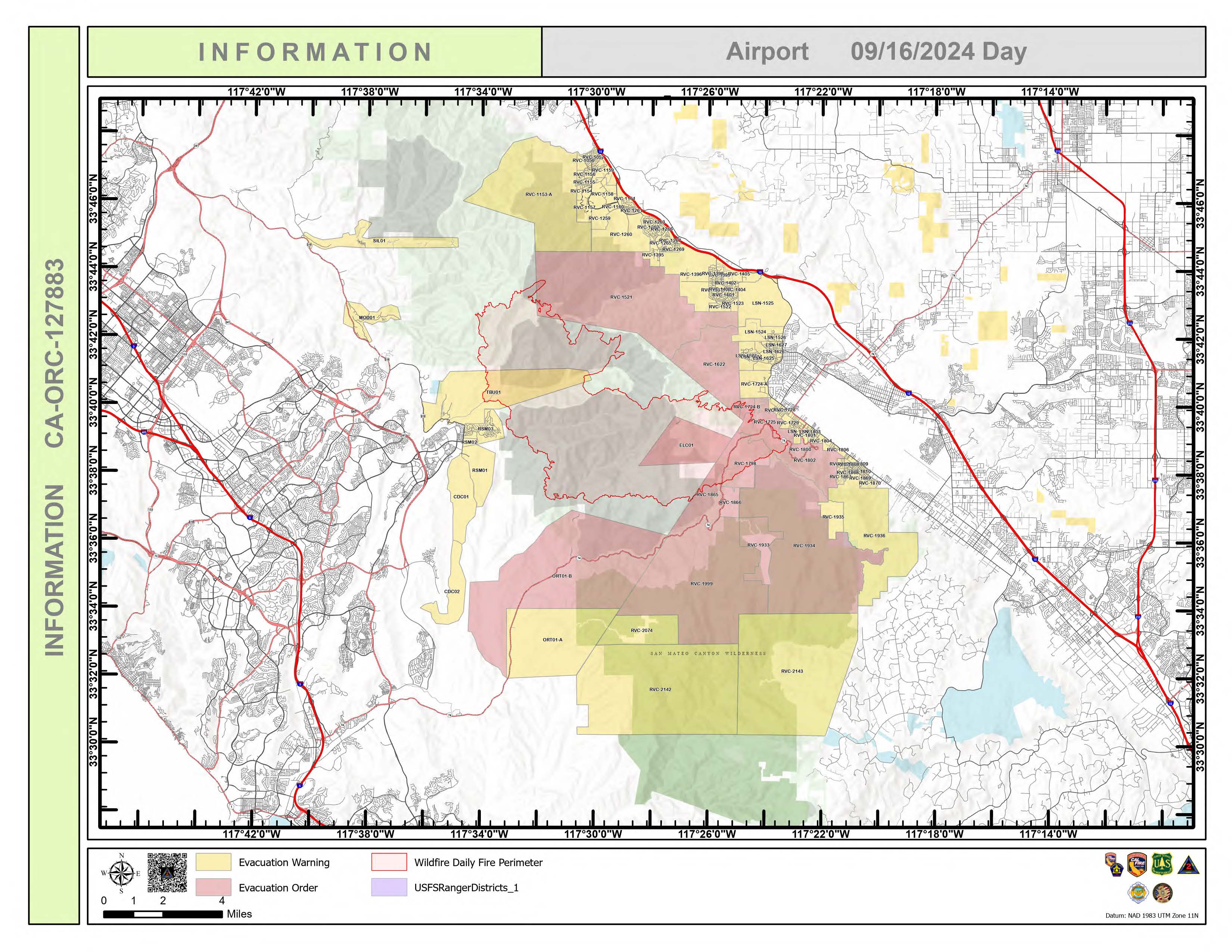
Airport Fire Incident Update 09 16 2024
Related Incident:
Publication Type: News
Location: Trabuco Canyon, CA
Personnel: 2201
Start date: 09/09/24 1:00 p.m.
Cause: Human
Size: 23, 519
Percent contained: 31%
For a printable version of today's complete update for the Airport Fire, please see the related link below.
Fire crews made significant progress yesterday on all sides of the fire perimeter. Hot spots near Santiago Peak were extinguished with helicopter water drops. Fire activity is expected to be minimal today as a weather front passes through with cool temperatures and high relative humidity. It was a quiet night on the Airport Fire as welcome precipitation fell over the entire fire footprint.
Fire operations will take advantage of the weather and continue to construct direct fire lines north and south of the Holy Fire Scar. Lines are holding well from Joplin Trail to the Santiago Truck trail. Hot Shot crews spiked out along the southern perimeter of the fire are making good progress digging fire line while traversing steep, rough terrain. Helicopters are providing crew supplies using sling loads. Direct handline in the canyon above Lake Elsinore is also being tied in. Fire operations in the El Cariso Area are mostly complete and equipment is being backhauled. Various utility companies are addressing service issues in the area. Faller modules will be arriving with chainsaws to address identified hazard trees. Protection of communities to the east, west and southeast remain as top priorities in addition to firefighter and public safety. Fire managers are focused on “connecting the dots” addressing any incomplete fire line sections.
Downed power lines are a safety concern for crews and the public. Use of generators and solar power could cause some downed power lines to be energized. Firefighters were warned to “consider ALL electrical lines hot” and use caution in all activities including driving. Fire crews, Cal Trans and utility companies are working together along the Ortega highway to identify and address hot spots, hazard trees, damaged guard rails, electrical lines, power poles and other issues.

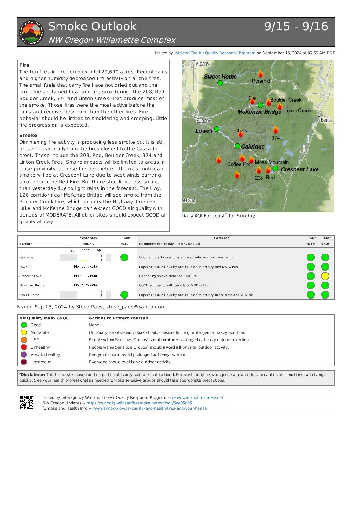
Willamette Complex North Daily Update 09 16 2024
Related Incident: North Willamette Complex
Publication Type: News
Willamette Complex North Update
Boulder Creek, Ore, Linton Creek, Pyramid, 374, and Roundtop Fires
Date: Monday, September 16, 2024
InciWeb: https://inciweb.wildfire.gov/incident-information/orwif-north-willamette-complex
Willamette Complex North Facebook Page: https://www.facebook.com/profile.php?id=61565845313387
Email: 2024.WillametteComplex.North@firenet.gov
Information line: 541-208-1262 Hours: 8 a.m. to 8 p.m.
Overview: Northern Rockies Incident Management Team 6 took command of the Willamette Complex North today at 6 a.m. Rain showers provided a wetting rain Sunday, reducing fire activity while also limiting ground and aerial firefighting efforts in higher elevations. Firefighters continue to extinguish areas of heat along OR 126 and improve containment lines. OR 126 is open to one lane only, guided by pilot car. OR 242 remains closed between mileposts 55 to 75. All fires remain under a full suppression strategy. Sunday’s showers are expected to yield to drier weather today for the Boulder Creek Fire, with low clouds and smoldering fire in areas with sun exposure and heavy fuels.
Boulder Creek Fire Evacuation Notices
LEVEL 3 (GO NOW) EVACUATION NOTICE: Scott Creek Road LEVEL 1 (BE READY) EVACUATION NOTICE: South of Highway 126 from milepost 53.5 east to Scott Creek Road and Horse Creek Road east of Foley Springs, Foley Springs, Forest Service Road #302, Belknap Springs Road South, Camp Yale Road, Yale Lane, North of Highway 126 East from the east end of Drury Lane to the end of North Belknap Springs Road Evacuation Notice Source: Visit www.LaneCountyOR.gov
Boulder Creek:
511 acres, 0% contained Located 5 miles east of McKenzie Bridge. Crews continue working along OR 126 to extinguish areas of heat. Firefighters are evaluating and addressing fire-weakened trees along the road corridor to reduce the risk of trees falling into the roadway.
Ore:
3,475 acres, 76% contained Located 7 miles northeast of Blue River. Following the successful firing operations below the Forest Service Road 1509, crews continue chipping efforts and removing combustible material. Minimal fire activity was observed with smoldering and smoke along the northern side.
Linton Creek:
1,301 acres, 0% contained Located in the Three Sisters Wilderness northeast of Eileen Lake. The fire received a wetting rain yesterday, limiting both ground and aerial firefighting efforts. Despite the precipitation, heat remain in large diameter trees. Today, crews will continue work on improving trails to use as fire line, prioritizing the Pacific Crest Trail.
Pyramid:
1,311 Acres, 98% contained East of Middle Santiam Wilderness. Crews are improving containment lines, working to reduce burnable fuels through mechanized mastication and chipping. Morning patchy fog and low clouds gave way to mixed sunshine and overcast skies over the fire area.
374:
58 acres, 0% contained Located in the Three Sisters Wilderness, northwest of Packsaddle Mountain. Smokejumpers are working to extinguish areas of heat and using the existing trail network as containment lines. The fire area received some precipitation yesterday, but large fuels are holding heat.
Roundtop:
Less than one acre, 100% contained. Near the 374 Fire and Little Roundtop Mountain. This fire remains contained and is in patrol status.
Road Closures: OR 126 is now open to one-lane traffic between mileposts 13 and 19.5 (intersection with OR 242). OR 242 remains closed to all traffic between the intersection with OR 126 and the Dee Wright Observatory (mileposts 55 to 75), due to the Linton Creek Fire. Use an alternate route; do not divert onto forest roads to avoid closures. Check for updates at: https://tripcheck.com/
Willamette National Forest Area Closures: Due to fire activity in the McKenzie River Ranger District, the Linton Creek Fire closure area includes Boulder Creek, 374, Roundtop, as well as other fires on the Middle Fork Ranger District including Young Grasshopper and Lowell Creek fires. Source: https://www.fs.usda.gov/detail/willamette/alerts-notices/?cid=fseprd552029.
Operational Video for the Chimney Fire 09 16 2024
Related Incident: Chimney Fire
Publication Type: News
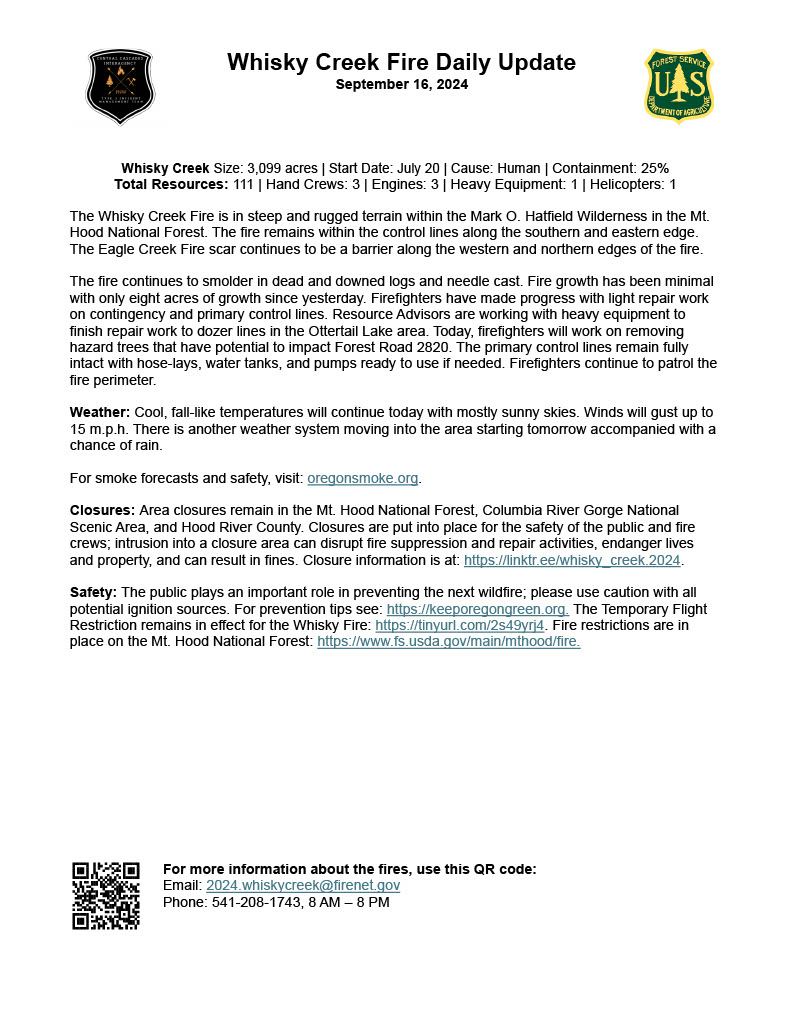
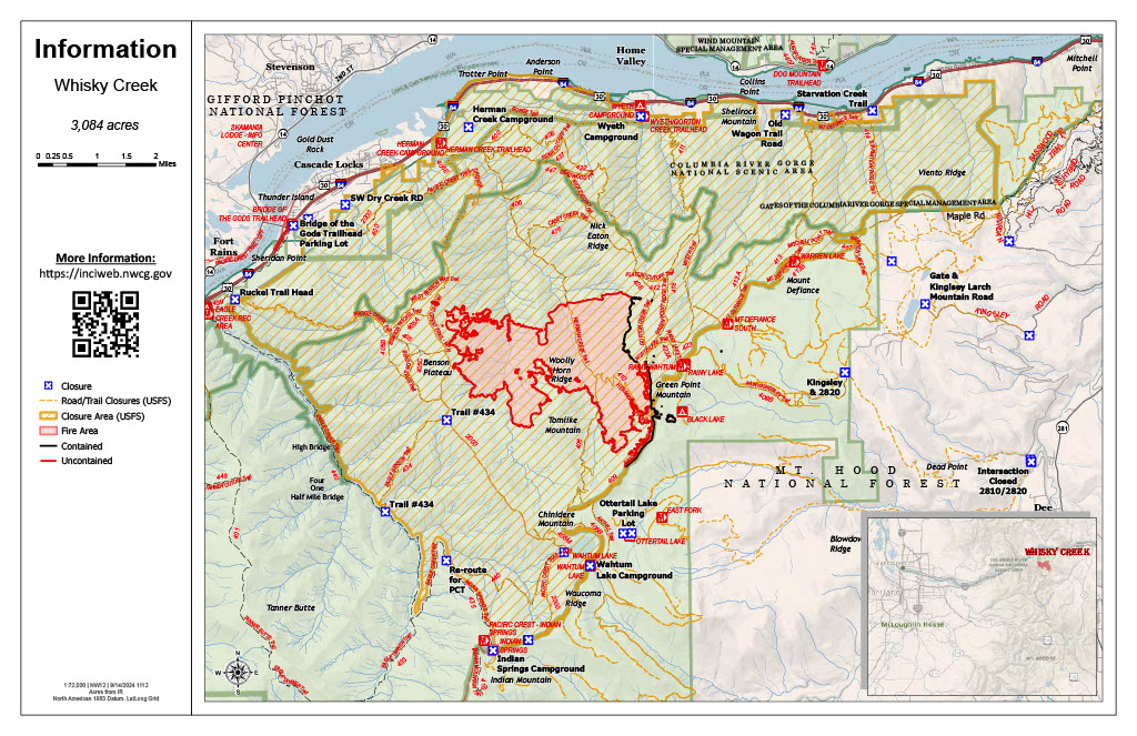
Whisky Creek Fire Daily Update 09 16 2024
Related Incident: Whisky Creek Fire
Publication Type: News
Whisky Creek Size: 3,099 acres | Start Date: July 20 | Cause: Human | Containment: 25%
Total Resources: 111 | Hand Crews: 3 | Engines: 3 | Heavy Equipment: 1 | Helicopters: 1
The Whisky Creek Fire is in steep and rugged terrain within the Mark O. Hatfield Wilderness in the Mt. Hood National Forest. The fire remains within the control lines along the southern and eastern edge. The Eagle Creek Fire scar continues to be a barrier along the western and northern edges of the fire.
The fire continues to smolder in dead and downed logs and needle cast. Fire growth has been minimal with only eight acres of growth since yesterday. Firefighters have made progress with light repair work on contingency and primary control lines. Resource Advisors are working with heavy equipment to finish repair work to dozer lines in the Ottertail Lake area. Today, firefighters will work on removing hazard trees that have potential to impact Forest Road 2820. The primary control lines remain fully intact with hose-lays, water tanks, and pumps ready to use if needed. Firefighters continue to patrol the fire perimeter.
Weather: Cool, fall-like temperatures will continue today with mostly sunny skies. Winds will gust up to 15 m.p.h. There is another weather system moving into the area starting tomorrow accompanied with a chance of rain.
For smoke forecasts and safety, visit: oregonsmoke.org.
Closures: Area closures remain in the Mt. Hood National Forest, Columbia River Gorge National Scenic Area, and Hood River County. Closures are put into place for the safety of the public and fire crews; intrusion into a closure area can disrupt fire suppression and repair activities, endanger lives and property, and can result in fines. Closure information is at: https://linktr.ee/whisky_creek.2024.
Safety: The public plays an important role in preventing the next wildfire; please use caution with all potential ignition sources. For prevention tips see: https://keeporegongreen.org. The Temporary Flight Restriction remains in effect for the Whisky Fire: https://tinyurl.com/2s49yrj4. Fire restrictions are in place on the Mt. Hood National Forest: https://www.fs.usda.gov/main/mthood/fire.