
Marsh Creek Fire Closure rescinded 09 17 2024
Related Incident: Marsh Creek
Publication Type: Closures
As of September 17, the Marsh Creek Fire closure has been rescinded
Swauk Creek Fire Update 09 17 2024
Related Incident:
Publication Type: News
Swauk Creek Fire
September 17, 2024
Estimated size: 331 acres
Containment: 37%
Start Date/Time: 9/8/2024 at 3:54 PM
Area of Origin: Adjacent to Highway 97, 14 miles east of Cle Elum, WA
Cause: Human
Structures Damaged: 0
Update: Yesterday, crews began a firing operation along the fire's northern flank. Crews spent multiple days preparing fire lines and ensuring the burn area was ready for firing. Around 3:30 p.m. Monday afternoon, the weather conditions were favorable, and crews began the firing operation. Overnight, crews staffed the fire, monitoring for any unexpected flare-ups. The firing operation will continue today while crews continue monitoring and working the fire edge. Mop-up has begun around the burnt areas and will continue into the coming days.
Firing operations are being used to safely consume the available fuels ahead of the active fire edge, reducing the potential for negative impacts and resource damage caused by higher-intensity fire. This improves our ability to contain the fire with direct control lines against the fire’s perimeter.
Smoke will remain visible to citizens and travelers in local communities and along Highway 97 during the firing operation. The fire will continue to be fully staffed to monitor and maintain control lines on the northern flank.
Forest Closures: The Okanogan-Wenatchee National Forest has area, road, and trail closures due to the Swauk Creek Fire. For a detailed list of closures, including a map of the closure area, please visit the Okanogan-Wenatchee National Forest Website at https://www.fs.usda.gov/alerts/okawen/alerts-notices/?aid=90533.
Road Closures: Highway 97 remains open. Due to the increased flow of fire vehicle traffic traveling in and out of the fire area, we ask that people drive slowly through the area using caution.
Weather: Low pressure dropping down the coast will bring cooler air, moistening humidity trends, and some cloud cover in the afternoon and evening. The chance for showers has decreased. Breezy to gusty northwest winds will be the main impact on the fire. Temperatures will be 67-72 degrees, with sunshine in the morning and increasing clouds in the afternoon and evening. Tonight, temperatures will cool to 46-48 degrees, becoming mostly clear overnight.
Evacuation Levels: Evacuation levels remain the same. They were updated as a precaution; there is no immediate residential threat from this fire. Evacuations can be found on the interactive map. Many Forest Service roads are affected in this area; please review the map if you want to know about a specific location/road.
Live map of active fires from Kittitas County:
https://kitcogis.maps.arcgis.com/.../minima.../index.html...
The First Creek area is currently closed to the public.
Notification Level 3 (Go Now) is shown on the map; however, this area has no residential structures.
Notification Level 2 (Get ready)
- Residences east of US 97 north of fire to Liberty Rd
- Forest Service Road 3506 south of fire to Upper Green Canyon Rd
Notification Level 1 (Be Fire Aware)
- The town of Liberty
- All Liberty Rd
- Forest Service Road 9726 and all of its extensions (including Deer Gulch, Pine Gulch, Robinson Gulch, and Harkness Gulch)
Currently, no evacuation notices are issued for residents south of First Creek or west of US Highway 97.
As always, conditions can change quickly; please stay alert and avoid the area if you feel unsafe.
Updated Fish Creek Fire Area Road and Trail Closure Order 040324313 09 17 2024
Related Incident:
Publication Type: Closures
U.S. Department of Agriculture, U.S. Forest Service
Bridger-Teton National Forest
Jackson & Blackrock Ranger Districts
Shoshone National Forest
Wind River District
Fish Creek Fire Area, Road, and Trail Closure
PROHIBITIONS
Pursuant to 16 U.S.C. § 551 and 36 C.F.R. § 261.50 (a) and (b), the following are prohibited on the National Forest System (NFS) area, roads, and trails in the Jackson & Blackrock Ranger Districts, Bridger-Teton National Forest, and the Wind River Ranger District, Shoshone National Forest, described below and shown on the attached map incorporated into this Order as Exhibit A (the “Described Area, Road, and Trails”):
1. Going into or being upon the Described Area. 36 C.F.R. § § 261.52(e)
2. Being on the Described Road. 36 C.F.R. § 261.54(e)
3. Being on the Described Trails. 36 C.F.R. § 261.55(a)
EXEMPTIONS
Pursuant to 36 C.F.R. § 261.50(e), the following persons are exempt from this Order:
1. Persons with Forest Service Permit No. FS-7700-48 (Permit for Use of Roads, Trails, or Areas Restricted by Regulation or Order), specifically exempting them from this Order or a written determination by a Forest Service authorized officer that a permit is not required under 36 C.F.R. § 251.50(e)(1) or (2);and
2. Any Federal, State, or Local Officer, or member of an organized rescue or firefighting resource in the performance of an official duty.
DESCRIBED AREA/ROADS/TRAILS
Bridger-Teton National Forest Fish Creek Fire Closure area boundary begins where it meets the SW corner of Shoshone National Forest Fish Creek Fire area boundary that abuts the Continental Divide and Bridger-Teton National Forest boundary, at the boundary of Sections 22 and 27, T43N R110W. Continuing S along the continental divide and Forest Boundary to the intersection of trail 7094. Then S along the west edge of trail 7094 to a point on the divide due east of the end of the Purdy creek trail 4111, in section 16, R110W, T42N. W along this bearing to the NE end of the Purdy creek trail in Section 17, R110W, T42N. SW along the N edge of the Purdy Basin Trail to its intersection with the South Fork of Fish Creek trail 4077. W along the N edge of the South Fork of Fish Creek Trail 4077 to its intersection with the North Fork of Fish Creek Trail 4078. W along the north edge of the North Fork of Fish Creek Trail 4078 to its intersection with motorized trail 30410. W along the north edge of motorized trail 30140 to its intersection with Cottonwood Creek Trail 4202. Then N on the east edge of Cottonwood Creek trail 4202 to a point due east of the east end of motorized route 30417. Then W along the south edge of motorized route 30417 to the hydrographic divide. Then N along the hydrographic divide to its intersection with the hydrographic divide between Jackson and Blackrock Ranger Districts in section 34, R112W, T43N. Then NW and N to Dallas Fork/South Fork Spread Creek divide, then north along trail 30240 to its intersection with South Fork
Spread Creek Road (30100), then N and along and including the same road to its intersection with Hatchet Road (30160), then following and including Flagstaff Road (30100) east to its intersection with US Highway 26/287. Then east along the south edge of US Highway 26/287 to its intersection with the Continental Divide at Togwotee Pass, then south along the Continental Divide to its intersection with the origin point of the closure at the boundary of Sections 22 and 27, T43N R110W.
The Shoshone National Forest Fish Creek Fire Closure area boundary begins at the SE corner of the Bridger-Teton National Forest Fire closure area. Continuing E along the N side of the section line dividing T43N R110W Sections 27 and 22 to Forest Service Road (FS RD) 540. The closure area continues NW on the W side of FS RD 540 to the intersection with FS RD 540.1D. Continuing NW along the W side of FS RD 540.1D to the intersection with FS RD 540.1E, the closure continues NW on the W side of FS RD 540.1E to the W side of Pelham Lake Creek. Extending E on the NW side of Pelham Lake Creek to the confluence of the Wind River, the closure crosses the Wind River to the private property boundary. At the private property boundary, the closure continues N then E on the W side of the property boundary to Highway (HWY) 26/287. The closure area continues N then W along the south side of Highway 26/287, then W along the south edge of the Falls Campground, then W along the south side of Highway 26/287 to its intersection with the Continental Divide at Togwotee Pass, then south along the Continental Divide to its intersection with the origin point of the closure at the boundary of Sections 22 and 27, T43N R110W.
The Described Roads and Trails include the following NFS roads and trails located within and bordering the Described Area:
Bridger-Teton National Forest:
1. Portion of NFS Road 30750 (Moccasin Basin Road), to its intersection with NFS Rd
30800.
2. Forest Road 30100 (Flagstaff/South Fork Spread Creek Road) in its entirety.
3. Forest Road 30800 in its entirety.
4. NFS Trail 30240 in its entirety.
5. FS RD 30120 (North Fork Spread Creek) in its entirety.
6. FS RD 30140 (Grizzly Creek) in its entirety.
7. FS RD 30010 (Two Ocean Basin) in its entirety.
8. NFS Trail 4079 (Cottonwood Creek Trail), in its entirety.
9. NFS Trail 4106 (Spruce Creek Trail), in its entirety.
10. NFS Trail 6107 (Two Ocean Basin Trail) in its entirety.
11. NFS Trail 6071 (South Fork Spread Creek) in its entirety.
12. NFS Trail 4109 in its entirety.
13. NFS Trail 4110 in its entirety.
14. NFS Trail 4112 in its entirety.
15. NFS Trail 4078A in its entirety.
16.NFS Trail 4010N in its entirety.
17. NFS Trail 4104 in its entirety.
18. NFS Trail 4102 in its entirety.
19. NFS Trail 4105 in its entirety.
20. NFS Trails 4103 4103E in their entirety
21. FS RDs 30415, 30415A, 30418, 30419 at those locations east of the hydrographic divide between Dry Cottonwood Creek and Sohare Creek.
Shoshone National Forest:
1. FS RD 584 in its entirety
2. FS RD 537 in its entirety
3. That portion of FS RD 540 north of its junction with FS RD 540.1D
4. FS RD 540.1A in its entirety
5. That portion of FS RD 540.1E northwest of Pelham Lake Creek
6. FS RD 645 in its entirety
7. MT10 in its entirety
8. FS RD 589 in its entirety
9. FS RD 590 in its entirety
10. FS RD 591 in its entirety
11. That portion of FS Trail 823.1E Sublette Pass Trail from US Highway 26/287 in ½ mile from Togwotee Pass.
PURPOSE
The purpose of this Order is to protect public safety during the Fish Creek Fire.
IMPLEMENTATION
1. This Order shall be in effect from September 18, 2024, at 6:00 A.M. through October 15, 2024, at 6:00 A.M., unless rescinded.
2. A map identifying the Described Area/Roads/Trails is attached and made part of this Order as Exhibit A. For a digital version of this Order and Exhibit A, go to
https://www.fs.usda.gov/alerts/btnf/alerts-notices
3. Unless otherwise expressly defined in this Order, the terms used in this Order are defined by the regulations of the Secretary of Agriculture, 36 C.F.R. Chapter II, Parts 200-299. If there are terms in this Order that are not expressly defined in the Order or 36 C.F.R. Chapter II, Parts 200-299, their meaning shall be determined by their plain language definitions.
4. A violation of the above prohibitions is punishable as a Class B misdemeanor by a fine of not more than $5,000 for individuals and $10,000 for organizations, or by imprisonment for not more than six months, or both. 16 U.S.C. § 551; 18 U.S.C. §§ 3559, 3571, and 3581.
5. Contact the Jackson Ranger District in Jackson, WY, (307) 739-5400, and BridgerTeton National Forest Supervisor’s Office in Jackson, WY, (307) 739- 5500, or the Wind River Ranger District in Dubois, WY, (307) 455-2466 for more information about this Order.
6. This Order supersedes any previous Orders prohibiting the same or similar acts in the same Described Area.
Signed and issued on September 17, 2024.
Miners Complex Daily Update 09 17 2024
Related Incident: Miners Complex Fires
Publication Type: Announcement
11:00 AM, September 13, 2024
Estimated size: 1,098 acres
Start Date/Time: July 17, 2024
Area of Origin: 21 air miles east of Darrington WA
Cause: Lightning
Fuels/Topography: timber, rugged terrain
Structures Damaged: None, there are no homes threatened at this time.
Evacuations: None
The Miners Complex consists of eight wildfires caused by lightning strikes in the Mt. Baker-Snoqualmie National Forest. The fires included in the complex are Miners Fire, Vista Ridge Fire, Dolly Creek Fire, Sulphur Three Fire, Sulphur Four Fire, Sulphur Thirty-Four Fire, Plummer, and Middle Ridge Fire.
Update: Firefighters have begun preparations for re-opening the closures on the Suiattle River Road, as the Miners Complex Fires continues to show smoke at high elevations. Structure protections have been removed, and assessments of fire impacted trails are being completed over the next few days to determine suitability for potential reopening.
Weather: Temperatures cooler today and below average. A slight chance of rain this afternoon and evening. Drier Wednesday and Thursday although humidities remain high. Cooler and wetter weather Friday into the weekend, keeping fire danger low. High temperatures around 62°F, with west winds 5-8mph.
Smoke: For more information on smoke and air quality please visit: https://wasmoke.blogspot.com/
Closures: The following is a summary of the areas closed due to the fires in the Miners Complex: Pacific Crest National Scenic Trail #2000.2 from Mica Lake to Suiattle Pass, Suiattle River Trail #784, Miners Ridge Trail #785, Buck Creek Pass Trail #789, Miners Cabin Trail #795, Grassy Point Trail #788, Sulphur Mountain Trail #794, Sulphur Creek Trail #793, Sulphur Creek Campground, Sulphur Creek Trailhead, and the Downey Creek trailhead. Suiattle River Road, closure beginning at Downey Creek trailhead. The full Closure Orders visit: https://www.fs.usda.gov/mbs Forest Restrictions: The Mt. Baker-Snoqualmie has lifted the full campfire ban and forest-wide shooting restrictions, effective 8/28/2024. Additional details at: www.fs.usda.gov/mbs
###
Chimney Fire Area and Trail Closure 09 17 2024
Related Incident: Chimney Fire
Publication Type: Closures
The previous closure order for the Chimney Fire was rescinded today at 10:59 a.m. and replaced with a smaller closure area.
Pincer Two Fire Daily Update 09 17 2024
Related Incident: Pincer Two Fire
Publication Type: Announcement
11:00 AM, September 17, 2024
Estimated size: 211 acres
Start Date/Time: July 17, 2024
Area of Origin: Johannesburg Mountain. 1 Mile East of Mineral Park C.G.
Cause: Lightning
Fuels/Topography: Timber, rugged terrain
Structures Damaged: None, there are no homes threatened at this time.
Evacuations: None
Closures: Cascade River Road at and including Marble Creek Campground, Mineral Park Campground, and all tributary roads, trailheads, and trails are all closed. The public is not to enter the area for public and firefighter safety.
Full closure orders available at: https://www.fs.usda.gov/mbs
Update: Firefighters have begun preparations for re-opening Cascade River Road and aim for the road to be open on Friday, September 20th. The Pincer Two fire is still burning at 3,500 feet and will likely continue to smolder at high elevations into October. However, the fire should not pose any danger to the visiting public, hiking trails, the road, or any infrastructure values at risk. Firefighters are actively working on rehabilitation of the area and with resource advisors to return the area to its natural state, after being impacted by fire. The closures set to be lifted on the 20th include the Cascade River Road and all tributary roads, trailheads and trails. For information regarding backcountry permits in the North Cascades that are accessed along Cascade River Road, please contact noca_wilderness@nps.gov.
Safety: Please consider the following safety tips for recreating in fire impacted areas:
- Do not camp in an area with standing dead or fire impacted trees, as they are likely to fall.
- If there are high winds, consider adjusting your schedule if possible to avoid spending time in recently burned areas. During high winds, fire impacted trees are much more likely to fall.
- Erosion can be common after fires, leading to poor or unstable trail conditions. Stay situationally aware when hiking on burned over trails – look for any areas of the trail that are eroding, especially at high elevations next to drop-offs. .
Smoke: For more information on smoke and air quality please visit: https://wasmoke.blogspot.com/
Air Space Restrictions: There are no air space restrictions at this time.
Forest Restrictions: The Mt. Baker-Snoqualmie has lifted the full campfire ban and forest-wide shooting restrictions, effective 8/28/2024. Additional details at: www.fs.usda.gov/mbs
###
BLACK EAGLE FIRE CLOSURE REDUCTION 09 17 2024
Related Incident:
Publication Type: Closures
The Salmon‐Challis National Forest has reduced the Black Eagle Fire Closure, Order Number: 04‐13‐24‐020.
Description of #04‐13‐24‐020:
DESCRIBED ROADS:
NFS lands, roads and trails on the Salmon‐Cobalt, and North Fork Ranger Districts of the Salmon‐Challis National Forest within the area bounded by the following:
Beginning at the intersection of FS Road 112 and 055 (Panther Creek Rd) to the intersection of FS Road 112 and 113. Then following FS Road 113 to its intersection with trail 029 (FS Roads 112 and 113 are closed to the public). Then following the Frank Church River of No Return Wilderness Boundary to the Golden Trout Lake Trailhead, including the Big Horn Crags Campground and crossing over into the Frank Church River of No Return Wilderness and onto the ridge to the West of Wilson Creek, then going South to Middle Fork Peak. From Middle Fork Peak to the Frank Church River of No Return Wilderness Boundary to trail 053 then running along Little Jacket Creek to Trail 051, then following Trail 051 to Birdseye Creek to Forest Road 245 at its intersection with Panther Creek road 55. Then following the western side of FS Road 55 (Panther Creek), to the intersection of FS Road 55 and 112.
The purpose of this order is to protect public health and safety during the Black Eagle/Red Rock Fire. This Order shall be in effect from September 17, 2024, at 8:00 am until rescinded.
Visit our website at: www.fs.usda.gov/scnf/, ‘Like Us’ on Facebook @salmonchallisnf, and ‘Follow Us’ on X @salmonchallisnf.
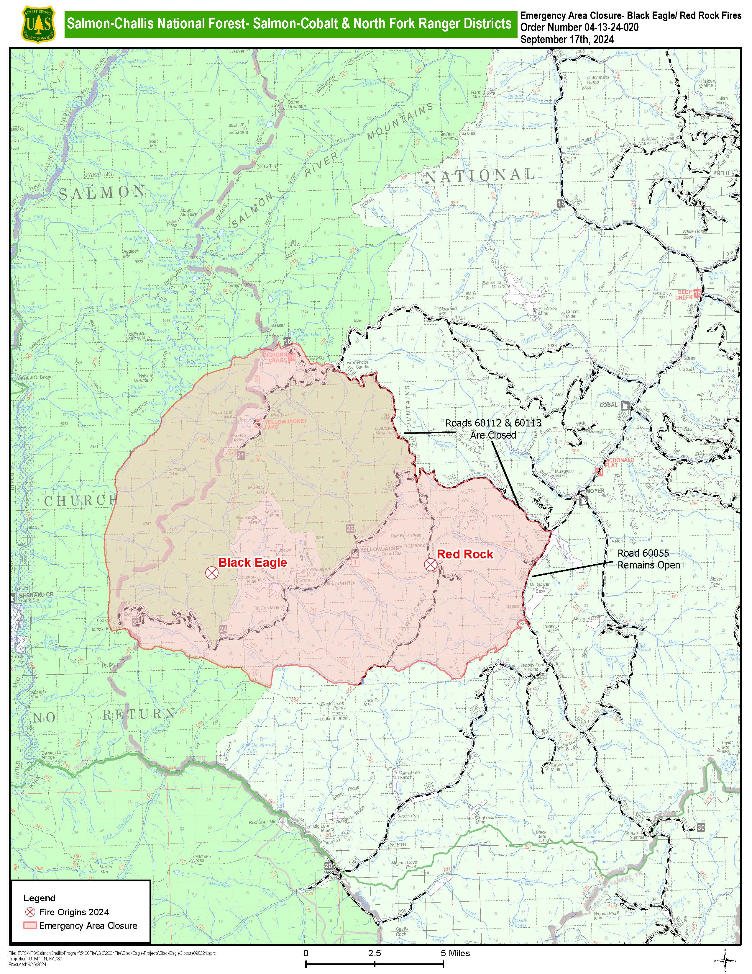
Updated forest closure map
Lava Fire Daily Update September 17 2024 09 17 2024
Related Incident:
Publication Type: News
Tuesday September 17, 2024
Per Gem County Sherriff’s Office please note that county roads closed by the fire remain closed (listed below).
Adams County Sheriff’s Office downgraded to level 1 “READY” for all Adams County residents.
A Community Meeting will be held in Cascade TOMORROW, Wednesday September 18 at 7:00 p.m. at the Cascade Fire Department, 109 E. Pine St. Cascade, Idaho
Overview: The Lava Fire is on the Boise and Payette National Forests as well as lands administered by the Bureau of Land Management and the Idaho Department of Lands. The fire is located north of Emmett, ID and west of Lake Cascade. The fire was started by lightning on Monday, September 2nd and is burning in tall grass, brush, and timber.
The Lava Fire is currently 97,844 acres with 33 percent of the perimeter contained. There are 825 personnel assigned, including 19 crews, 2 large helicopters, 1 small helicopter, 58 engines, 11 bulldozers, 16 water tenders, 6 excavators, 7 skidders and 8 ambulances.
Any property that is currently evacuated or impacted by Forest Service closures will remain unchanged until the Sheriff’s departments, fire managers, and emergency management departments deem the area safe for reentry. These are being evaluated daily to insure accuracy.
Operations: Yesterday, structure protection crews continued protecting homes and structures around God’s Acres and the church camp. Bulldozer line construction and improvement continued from Cold Spring Ridge to Cascade Lake behind structures, tying together hand lines crew securing the southern perimeter of the fire edge. Firefighters strengthened fire lines along west mountain road toward Willow Creek subdivision. Resources are holding the containment line on the western flank, working on suppression repair, and patrolling for any heat sources. No heat sources were found around the structures at Second or Third Fork Road during a reconnaissance flight over the southern flank of the fire. On the eastern flank, mop up and chipping operations continued around structures on the southeast corner along Forest Service Road 404 and 421. Bulldozers completed line construction on the northern flank. Crews scouted lines east toward Anderson Creek to connect with crews working west from Little Weiser River. Last night, 38 people attended the Indian Valley Community Meeting for the Lava Fire.
Today, firefighters will evaluate conditions impacted by yesterday’s rainstorm to ensure safe conditions before beginning work. Rain received yesterday may impact access, road conditions, natural resources, and create slick surfaces throughout the fire perimeter. Firefighter and public safety remain the number one priority. After conditions are deemed safe and suitable, firefighters will construct and improve handlines and bulldozer lines with engines, hand crews, heavy equipment, and chippers around the fire perimeter. Helicopters will support ground resources while UAS platforms will be used to gather intelligence along the fire perimeter.
Structure protection continues all around the fire including God’s Acre, the church camp, Tamarack Ski Resort, Little Weiser Road, and structures near the fire. Activities include assessments, protection plans, and equipment installation.
On the northern flank, fire crews are working between the 435 and B roads to strengthen the fire line where the fire had previously slopped over the line. A mix of hand crews and heavy equipment will strengthen line that was constructed yesterday on the northeastern perimeter along the Cold Springs Ridge toward Cascade Lake.
On the eastern flank, firefighters will focus on suppression repair and backhaul of equipment. They will extinguish areas of heat detected around Forest Service Roads 404 and 421 as well as structures near the fire’s edge.
On the southern flank, firefighters will continue to make progress moving northeast to secure line along Forest Service Road 653, strengthening the line to the Gross community. Crews will mop up and search for heat sources by cold trailing west of Tree Spring Mountain Area.
On the western flank, personnel continue to patrol all control lines north to south for heat by mopping up threats to control lines. They will grade roads with motor graders for suppression repair as conditions allow. Patrolling continues around the range allotments, grasslands, and private property outside the fire perimeter line.
Weather/Fire Behavior: Today, storms will be capable of producing gusty and erratic winds, lightning, and heavy rainfall. Weather will clear late Tuesday leading to cooler, drier weather conditions. After the system passes, temperatures will be 15-20 degrees below normal with a high of 56 degrees. Relative humidity is 70 percent, and we will see westerly winds 5-10 mph with 15 mph gusts. Lightning has been reported and rain amounts were not enough to extinguish the fire. Smoldering will continue in heavy ground fuels. No fire spread is expected today but as we move into the cooler and drier weather, fire activity will return to smoldering and creeping.
Evacuations:
Adams County Sheriff’s Office Downgraded to a Level 1 “READY” for all Adams County residents. These evacuations notices are effective as of Tuesday September 17, 2024.
Gem County Sheriff’s Office A LEVEL 2 “Ready” Evacuation notice has been issued to residents on Third Fork Road (North of Nesbitt Lane), Second Fork Road (North of Nesbitt Lane), and the Sage Hen Reservoir area. A LEVEL 1 “READY” Evacuation has been issued for Nesbitt Lane residents.
Gem County Road and Bridge issued the following road closures: Third Fork Road at Nesbitt Lane, Second Fork Road at Nesbitt Lane, and Nesbitt Lane. The Sweet-Ola Highway is closed at the High Valley intersection in Ola. Please be advised that the Gem County Sheriff’s Office is staffing the road closure check points.
Valley County Sheriff’s Office zones 4 – 11 are in a LEVEL 2 “SET” Evacuation notice.
Forest Closures and Restrictions: The Boise and Payette National Forests implemented a joint Lava Fire Area, Road, and Trail Closure for public and firefighter safety. The closure includes Forest Service lands north of the 601 Road (approximately 7 miles southwest of Smiths Ferry) and north all the way to the northernmost extent of Lake Cascade. The extent of this closure order is being re-evaluated due to firefighting progress and recent precipitation. The public can expect to see changes later this week.
A temporary flight restriction is in effect in and around the fire area. This includes the use of personal drones. If you fly, we cannot fly.
Pine Residents moved to SET 09 17 2024
Related Incident: 2024 - West Fire - TNF
Publication Type: Announcement
"SET" Advisory for Pine Residents of the Pine Creek Canyon Zone
Date: 09/17/2024
Time: 10:00
As a result of firefighting activity on the West Fire, The Gila County Sheriff's has issued a "SET" status on the Ready, Set, Go model for the following areas of Pine due to anticipated fire activity.
Pine Creek Canyon Zone - Everything east of Pine Creek Canyon and North up to and including Camp Lomia.
There will be a community meeting/open house on Tuesday Sept 17th from 4-6 p.m. at the Pine Community Center to go over planned fire operations.
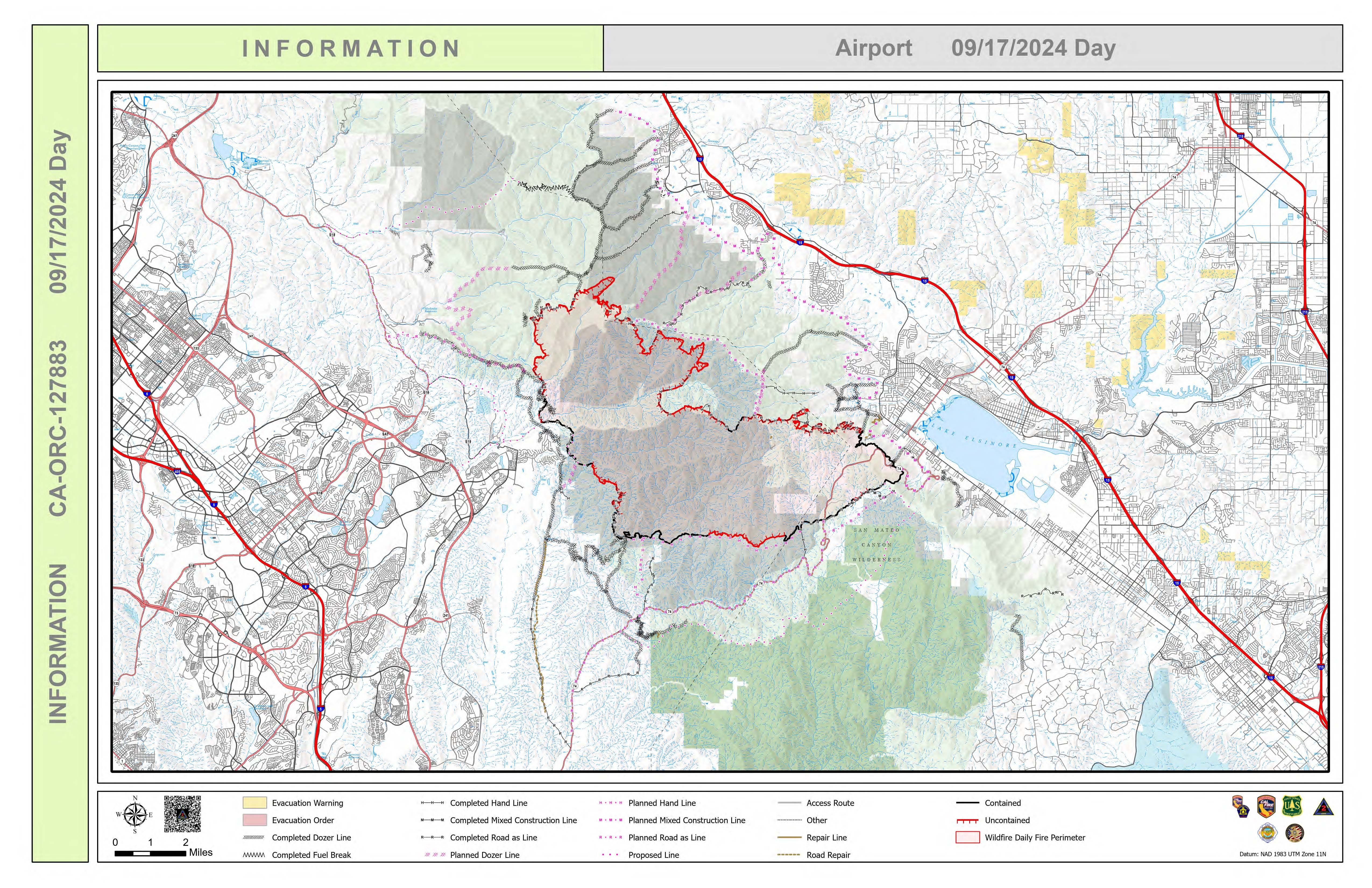
Airport Fire Incident Update 09 17 2024
Related Incident:
Publication Type: News
Location: Trabuco Canyon, CA
Personnel: 2201
Start date: 09/09/24 1:00 p.m.
Cause: Human
Size: 23, 519
Percent contained: 31%
For a printable version of today's complete update for the Airport Fire, please see the related link below.
Fire crews will take advantage of favorable weather conditions again today in an effort to connect incomplete pieces of fireline around the perimeter. Along the southern portion of the fire, there are areas that are inaccessible to bulldozers and firefighters to perform continuous handline or dozer line due to the presence of natural features such as rock cliffs and other unreachable terrain.
Areas that are holding heat beneath the brush canopy in rocky, steep areas have a higher potential for roll out of burning vegetation. In these areas, secondary lines, also known as contingency dozer lines, are being constructed as a precaution against roll out and fire spread. Many areas within the fire perimeter have the potential for minor flareups.
Night crews located some spots across the line last night in the northeast portion of the fire near Santiago Peak and were able to extinguish them. Additional crews have arrived to construct line north of Silverado Ridge to tie in to existing dozer line. Mop up and line reinforcement continues in the El Cariso area. Fire operations are focused on continued direct suppression using ground crews that will be assisted air resources when needed. Warmer, dryer weather conditions are anticipated this weekend.
