
Maury Mountains Closure Area Reduced 09 17 2024
Related Incident:
Publication Type: Closures
Prineville, Ore., September 17, 2024— Following significant progress in firefighting efforts, the Ochoco National Forest, in consultation with fire management officials and the Crook County Sheriff’s Office, has reduced the Wiley Flat Fire Area Closure in the Maury Mountains. This decision comes as containment lines have been strengthened, reducing the immediate threat to public safety.
While key areas remain closed to allow firefighters to continue their work, this reduction opens up portions of the forest for public access. Fire officials will continue to monitor the situation closely to ensure that it remains safe for the public to return to more areas as conditions improve.
We recognize the importance of these lands to the community, especially during hunting season, and appreciate your cooperation throughout the closures. Our priority remains the safety of both the public and our firefighters, and we will only lift restrictions as it becomes safe to do so.
The reduced closure will stay in place until further progress is made and will be reassessed regularly. We ask the public to continue respecting all closure signs and stay informed on current conditions.
For updated closure maps and information, please visit the Ochoco National Forest website.
For the latest evacuation information please visit the Crook County Sheriff’s Office Facebook and webpage.
Three Phases of Wildfire Recovery 09 17 2024
Related Incident: Davis Fire Burned Area Emergency Response (BAER)
Publication Type: Announcement
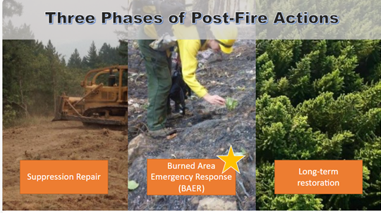
There are three phases of recovery following wildfires on federal lands:
- Fire Suppression Repair is a series of immediate post-fire actions taken to repair damages and minimize potential soil erosion and impacts resulting from fire suppression activities and usually begins before the fire is contained, and before the demobilization of an Incident Management Team. This work repairs the hand and dozer fire lines, roads, trails, staging areas, safety zones, and drop points used during fire suppression efforts.
- Emergency Stabilization-Burned Area Emergency Response (BAER) is a rapid assessment of burned watersheds by a BAER team to identify imminent post-wildfire threats to human life and safety, property, and critical natural or cultural resources on National Forest System lands and take immediate actions to implement emergency stabilization measures before the first post-fire damaging events. Fires result in loss of vegetation, exposure of soil to erosion, and increased water runoff that may lead to flooding, increased sediment, debris flows, and damage to critical natural and cultural resources.
- Long-Term Recovery and Restoration utilizes non-emergency actions to improve fire-damaged lands that are unlikely to recover naturally and to repair or replace facilities damaged by the fire that are not critical to life and safety. This phase may include restoring burned habitat, reforestation, other planting or seeding, monitoring fire effects, replacing burned fences, interpreting cultural sites, treating noxious weed infestations, and installing interpretive signs.
BAER SAFETY MESSAGE 09 17 2024
Related Incident: Davis Fire Burned Area Emergency Response (BAER)
Publication Type: Announcement
Everyone near and downstream from the burned areas should remain alert and stay updated on weather conditions that may result in heavy rains and increased water runoff. Flash flooding may occur quickly during heavy rain events--be prepared to act. Current weather and emergency notifications can be found at National Weather Service website: https://www.weather.gov/rev/.
Lava Fire Evacuation Notices The Gem County Sheriffs Office has ordered downgrade evacuations 09 17 2024
Related Incident:
Publication Type: Closures
For Immediate Release
September 17th, 1445mdt
Lava Fire Evacuation Notices
The Gem County Sheriff’s Office has ordered downgrade evacuations from Level II-Yellow-“Be Set” to Level I-Green-“Be Ready” for the following:
- Residences on Third Fork Road, North of Nesbitt Lane.
- Residences on Second Fork Road, North of Nesbitt Lane.
Residents on Nesbitt Lane have been at level I-Green-“Be Ready” and will remain at level I-Green-“Be Ready” status.
The wet weather has aided in the decision to downgrade based on fire control. The rain and current conditions have brought potential concerns to the area including mudslides, flash floods, and falling rocks and trees. Please be aware of the surroundings and the potential road hazards.
###
Middle Fork Complex Community Meeting Sept162024 09 17 2024
Related Incident:
Publication Type: Announcement
Great Basin Team 5 team members meet with the public to update them on the Middle Fork Complex, answer questions and thank the community for all their hospitality during their term of service.
https://youtu.be/RxKC2gvakdQ?si=A39A0sxW8SUSMnbp
Settings - change map background and toggle additional layers
Filter - control incident types displayed on map.
Zoom to your location
Reset map zoom and position
Could not determine your location.
Show Legend
 Wildfire
 Prescribed Fire
 Burned Area
Response
Burned Area
Response Other
Other
Davis Fire Burned Area Emergency Response (BAER)
Unit Information
Incident Contacts
Deschutes County Lowers All Evacuation Levels on the Bachelor Complex 09 17 2024
Related Incident: Bachelor Complex Fires
Publication Type: Announcement
With continued the success of fire operations and improved conditions, fire managers are recommending dropping all evacuation notices on the Little Lava/Bachelor Complex.
The Deschutes County Sheriff’s Office in coordination with the Sunriver Police Department is lowering all evacuation levels to normal status today.
Even though evacuation levels are dropped, there will be continued hazards near the fires and fire operations.
The Deschutes National Forest has implemented an Emergency Forest Closure around these fires.
For more information, please go to: https://www.fs.usda.gov/main/deschutes/home
For up-to-date incident information, go to: http://deschutes.org/emergency
Evacuation Zone Status Change for Red Rock and Black Eagle Fires 09 17 2024
Related Incident:
Publication Type: Announcement
THERE HAVE BEEN CHANGES IN THE EVACUATION ZONE STATUSES THEY ARE AS FOLLOWS:
ZONE 1- WILL REMAIN IN “GO” STATUS
ZONE 2- HAS BEEN RESCINDED
ZONE 3- WILL REMAIN IN “READY” STATUS
ZONE 4- WILL REMAIN IN “READY” STATUS
Zone 1: Yellowjacket drainage
Zone 2: Cobalt to Forney
Zone 3: Forney to road #252 to road #103 and back to Moyer
Zone 4: Silver Creek, Rams Creek, and Camas Creek from Hammer Creek to White Goat Creek.
Click here for more details
KXGV Radio for September 17 2024 09 17 2024
Related Incident:
Publication Type: Announcement
KNGV Radio host RC interview outgoing Incident Commander Trent Ingram from Great Basin Team 5 and Incoming Incident Commander Tony DeMasters from Great Basin Team 2.
https://youtu.be/JB8dSSQmULk?si=3zZC_-lFWxraR0rR
Line Fire Daily Status Update 09 17 2024
Related Incident: Line Fire
Publication Type: News
Below average temperatures and moderate relative humidity minimized Line Fire behavior overnight. The fire continued to be active in areas with remaining dry vegetation and heat. There is opportunity to make more progress strengthening control lines and mopping up hot spots over the next several days thanks to favorable weather.
An updated Smoke Outlook was published Monday. It can be found at fire.airnow.gov.
Damage Inspection Teams (DINS) are working in the fire area. So far, they have identified three structures that were damaged and one that was destroyed. Their inspections include residences, multi-family dwellings, outbuildings, and commercial buildings.
There are currently 56,100 structures threatened, including 11,400 under Evacuation Orders and 44,700 under Evacuation Warnings. Damage Inspection Teams (DINS) are working in the fire area. So far, they have identified 3 structures that were damaged and 1 that was destroyed. Their inspections include residences, multi-family dwellings, outbuildings and commercial buildings.
Governor Gavin Newsom has announced that the California National Guard will support the state’s ongoing response to the Line Fire. Through its activation, authorized under the Line Fire State of Emergency, the California National Guard is deploying:
- Four UH-60 Blackhawk helicopters for water bucket dropping operations
- Two C-130 aircraft with Modular Airborne Fire Fighting Systems (MAFFS)
- Four 20-person hand crews (80 soldiers). They will be assigned to the Line Fire on Thursday in support of CAL FIRE.
- One military police company to support the San Bernardino County Sheriff’s Department with traffic control points in evacuated areas.