
Actualizacin diaria del incendio Whisky Creek 09 17 2024
Related Incident: Whisky Creek Fire
Publication Type: News
Whisky Creek Size: 3,099 acres | Fecha de inicio: 20 de julio |Causa: De orígen humano |Contención 25%
Total de recursos: 111 | Equipos de obreros: 3 | Camiones de bomberos: 3 | Maquinarias pesadas: 1 | Helicópteros: 1
El incendio Whisky Creek se encuentra en un terreno escarpado y escabroso dentro del área de naturaleza Mark O. Hatfield en el Bosque Nacional Mt. Hood. Permanece dentro de las líneas de control a lo largo de los extremos sur y este. La huellas del incendio Eagle Creek continúan como barrera a lo largo de los extremos oeste y norte del incendio.
Sigue habiendo una intensidad mínima de fuego debido a las temperaturas más frescas y una mayor humedad relativa. A lo largo del extremo sur y secciones interiores creció un poco ya que se queman combustibles que no se habían quemado. Los bomberos han avanzado en ligeros reparos en las líneas de control de contingencia y secundarias. Las excavadoras han terminado de hacer reparaciones en el camino forestal 2810 dentro del área de Ottertail Lake. Hoy, las cuadrillas de mano evaluarán lo que es necesario para reparar el sendero forestal 409B y realizarán un plan para rehabilitar el sendero ya que es popular entre la comunidad de ciclistas de monte. Los bomberos continuarán patrullando las líneas de control primarias que permanecen completamente bien con mangueras, tanques de agua y bombas que están listas por si acaso llega a ser necesario usarlos.
Clima: Hoy se prevé que un sistema meteorológico se desplazará al área y vendrá con un 30% de probabilidad de lluvia. Una vez que haya desaparecido el sistema meteorológico, se irá secando el área hasta el miércoles por la tarde y durará hasta finales de esta semana.
Para saber el pronóstico de humo y seguridad, consulte: oregonsmoke.org.
Cierres: Los cierres de áreas permanecerán en el Bosque Nacional Mt. Hood, el Área Escénica Nacional Columbia River Gorge y el Condado de Hood River. Se establecen cierres para la seguridad del público y de los bomberos; La intrusión en un área de cierre puede interrumpir las actividades de extinción y reparación de incendios, poner en peligro vidas y propiedades, y puede resultar en multas. La información de cierre se encuentra en: https://linktr.ee/whisky_creek.2024.
Seguridad: El público juega un papel importante en la prevención del próximo incendio forestal; tenga cuidado con cualquier posible fuente de incendio. Para obtener consejos de prevención, consulte: https://keeporegongreen.org. La TFR sigue vigente para el incendio Whisky Creek: https://tinyurl.com/2s49yrj4. Las restricciones contra incendios están vigentes dentro del Bosque Nacional Mt. Hood: https://www.fs.usda.gov/main/mthood/fire.
Homestead Complex and Lane 1 Fire Daily Update 09 17 2024
Related Incident: Lane 1 Fire
Publication Type: News
Email: 2024.homesteadcomplex@firenet.gov
Fire Information Line: 541-208-7100 (Staffed 8 a.m. to 8 p.m.)
Facebook: https://t.ly/mSLvP
Inciweb: https://t.ly/syeHa
September 17, 2024
Firefighters are working to fully suppress eight fires, totaling approximately 35,650 acres. 800 people are assigned to these fires. Firefighters are using direct and indirect tactics to respond to all fires. Three of the fires in the Homestead Complex are 100% contained: the Salmon 33 Fire (275 acres) on August 24; the Reynolds Butte Fire (334 acres) on August 22; and the Lost Bucket Fire (34 acres) on July 29.
Crews are improving containment lines across the fire area by reducing fuels through mastication, chipping wood, and hauling fuel to landings away from the fire. There are still many miles of uncontained fire edge. Firefighters are mopping up, widening and strengthening fire lines by extinguishing hot spots and removing fuels. Crews are also clearing and repairing roads impacted by the fires and by fire suppression activities.
On the Horse Heaven Fire (2,741 acres, 56% containment), crews are masticating, chipping, and removing trees for access on the O25 and O26 roads on the west flank, and chipping along the east flank of the fire. Firefighters continue mopping up on the north flank of the fire along the 920 and 3831 roads. They are looking at improving the 3829 road to serve as fire line and backhauling any unneeded hose.
On the Fuller Lake (3,690 acres, 0% containment) and Bullpup (535 acres, 7% containment) fires, crews are using heavy equipment to masticate fuels on the 3810 road at the southwest edge of the fire, along the wilderness boundary. They will continue working south on that road today, weather permitting. The spot fire at the southwest edge is in patrol status as of yesterday. On the east flank, a module of local firefighters put hand line in place, tied into the riparian area and meadow. Today, they will continue to mop up and improve that line. They will also continue chipping on the 3816 road.
On the No Man Fire (2,090 acres, 44% containment), crews are working on the north flank with an excavator and backhoes and removing logs in the northwest corner of the fire edge. A reconnaissance flight looked down into the drainage yesterday and found only one visible smoke plume that was interior and fully surrounded by burned area. Firefighters are working today on two areas near the south flank with an engine, skidgen, and hand crew mopping up. A dozer and hand crews are working down the hill near Chilcoot mountain.
On the Lane 1 Fire (25,951 acres, 99% containment),road repairs and chipping are complete in the northwest corner. Chipping and mastication continue today on the Clark Creek road, with log hauling on the Sharps and Puddin Creek roads. Crews will begin mastication on the east flank near Adams Mountain today.
Closures and fire restrictions: Two closure orders impact every District of the Umpqua National Forest https://t.ly/Mvn6G. The forest is in High Fire Danger with Public Use Restrictions at Level 2 https://t.ly/LI4cd. A Bureau of Land Management (BLM) Roseburg District closure order is in effect for portions of BLM land bordering the Umpqua National Forest closure north of Steamboat https://t.ly/uWX6l. A BLM Northwest Oregon District closure is also in place for an area west of the Lane 1 fire https://t.ly/oW1lG.
Weather: Expect cooler weather with higher humidity today, low clouds, and a 40% chance of ¼ inch of rain. Winds will be 3 to 6 mph. Fuels should not become substantially wetter today, with fire continuing to smolder and creep. Wednesday starts a period of warmer, drier weather that may increase fire behavior in some areas.
West and Preacher Fires Update 09 17 2024
Related Incident: 2024 - West Fire - TNF2024 - Preacher Fire - TNF
Publication Type: News
Community Open House in Pine this afternoon
Highlights: There is a community Open House tonight from 4 p.m. to 6 p.m. at the Pine Community Center. Residents are encouraged to attend to receive information about the fires and upcoming operations. ASL services will be available.
Operations: Firefighters added containment to the West Fire on the northside along the Rim. Yesterday aerial ignitions were attempted in the West Webber drainages, but higher humidities prevented the desired fire effects. Crews hiked from Camp Geronimo west towards Turkey Springs and ignited by hand back towards the east. Across the rest of the fire area, crews focused on mopping up and holding the perimeter.
Today firefighters will look for more opportunities to continue ignitions towards the west as conditions begin to dry out again. The plan is to apply fire along the Control Road from the junction of the Webber Road to the west and on the west side of Camp Geronimo. Conditions are expected to be suitable for ignitions over the next several days and residents will likely see more smoke.
Up to a quarter of an inch of rain fell over the Preacher Fire yesterday. There is minimal fire activity and engines will continue to patrol and mop up. Repair of the containment lines continues.
Weather: Dry, breezy, and cooler than normal for Tuesday and Wednesday. Highs temperatures 68 to 75 degrees both days. Winds are predicted to be south-southwest 10 to 15 mph. Minimum humidity levels will range between 30 and 40% on Tuesday and lowering to 25 to 35% on Wednesday.
Safety: Two Temporary Flight Restrictions (TFR) are now in place over the area, which includes uncrewed aircraft systems or drones. The public is reminded, if you fly we can’t; unauthorized drone flights pose serious risks to firefighter and public safety and the effectiveness of wildfire suppression operations.
Closure: The Tonto National Forest has issued a closure for land surrounding the West Fire, this includes Pine Trailhead.
Evacuations: Pine residence on the east side of SR 87 and east of North Pine Creek Canyon road will be placed in SET status at 1000 a.m. today. Geronimo Estates residents near the West Fire are in SET status. An interactive map is available to stay up to date with evacuation levels related to both the West and Preacher Fires.
Receive emergency notifications from Gila County.
Smoke: During ignitions, smoke may settle in low-lying areas overnight. Residents are encouraged to close windows at night to avoid smoke impacts. Talk with your doctor and plan for how to manage your health conditions when it is smoky. Additional resources for how to prepare for wildfire smoke.
For the latest news and information about the Tonto National Forest, follow along on Facebook @TontoNationalForest, ‘X’ (formerly Twitter) @TontoForest or Instagram @tontonationalforest and on the Tonto National Forest website.
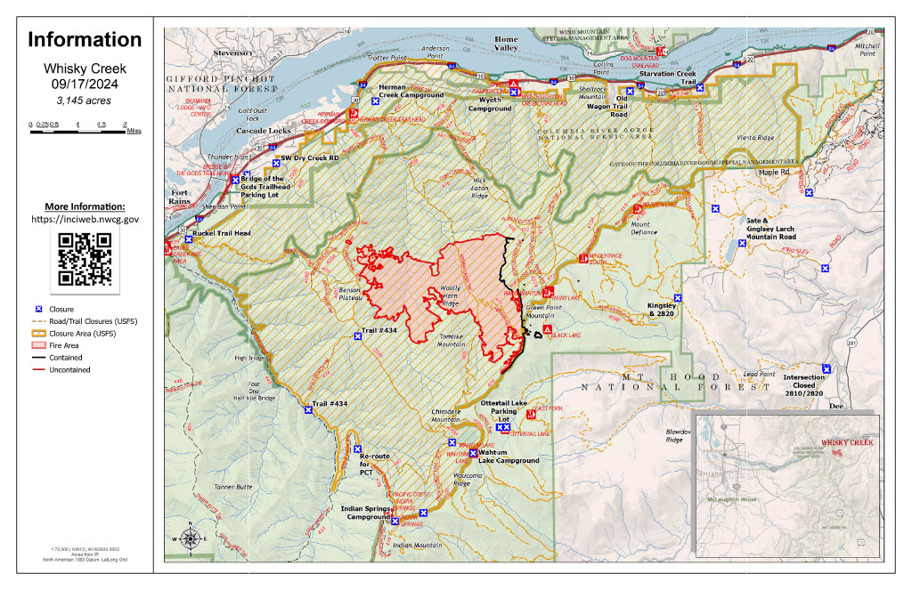
Whisky Creek Daily Fire Update 09 17 2024
Related Incident: Whisky Creek Fire
Publication Type: News
Whisky Creek Size: 3,099 acres | Start Date: July 20 | Cause: Human | Containment: 25%
Total Resources: 111 | Hand Crews: 3 | Engines: 3 | Heavy Equipment: 1 | Helicopters: 1
The Whisky Creek Fire is in steep and rugged terrain within the Mark O. Hatfield Wilderness in the Mt. Hood National Forest. The fire remains within the control lines along the southern and eastern edge. The Eagle Creek Fire scar continues to be a barrier along the western and northern edges of the fire.
Due to cooler temperatures and higher relative humidity, the fire continues to show minimal behavior. There is some growth along the southern edge and interior pockets where there are unburned fuels still being consumed. Firefighters have made progress with light repair work on contingency and secondary control lines. Excavators have finished repair work on Forest Road 2810 in the Ottertail Lake area. Today, hand crews will assess the needs necessary to repair Forest Trail 409B and develop a plan to rehab the trail which is popular with the mountain bike community. Firefighters will continue to patrol the primary control lines which remain fully intact with hose-lays, water tanks, and pumps that are ready to use if needed.
Weather: There is an anticipated weather system moving into the area today accompanied with a 30% chance of rain. After the weather system moves through, there will be steady drying in the area through Wednesday afternoon into later this week.
For smoke forecasts and safety, visit: oregonsmoke.org.
Closures: Area closures remain in the Mt. Hood National Forest, Columbia River Gorge National Scenic Area, and Hood River County. Closures are put into place for the safety of the public and fire crews; intrusion into a closure area can disrupt fire suppression and repair activities, endanger lives and property, and can result in fines. Closure information is at: https://linktr.ee/whisky_creek.2024.
Safety: The public plays an important role in preventing the next wildfire; please use caution with all potential ignition sources. For prevention tips see: https://keeporegongreen.org. The Temporary Flight Restriction remains in effect for the Whisky Fire: https://tinyurl.com/2s49yrj4. Fire restrictions are in place on the Mt. Hood National Forest: https://www.fs.usda.gov/main/mthood/fire.
Coffee Pot Fire Evacuation Update 09 17 2024
Related Incident: Coffee Pot Fire
Publication Type: Announcement
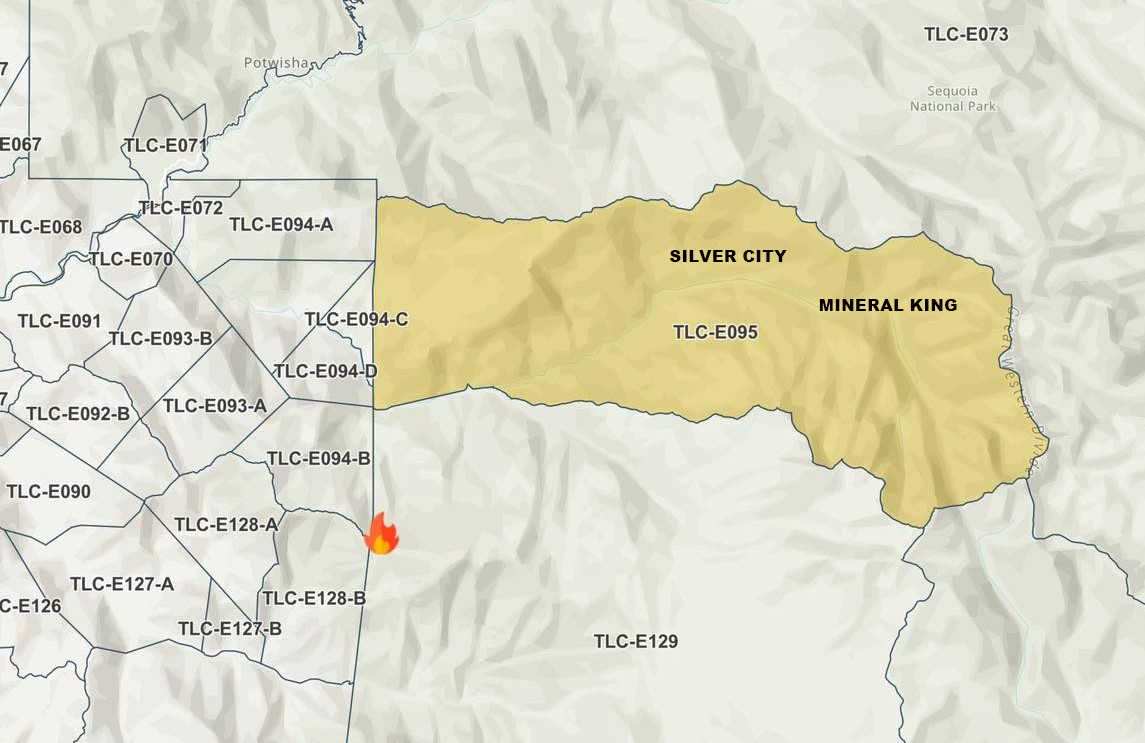
Tulare County Fire Department lifts Coffee Pot Fire evacuation warnings for the following areas effective Tuesday, Sept. 17, 2024.
Zones TLC-E094-B, TLC-E094-D and TLC-E094-C. The area includes east of River Hill, north of Case Mountain, west of Mitchell Ranch, and the community of Oak Grove. West of the National Park Boundary, north of the East Fork of the Kaweah River, east of Oak Grove. The area south of the East Fork of the Kaweah River, approximately a half mile southeast of Oak Grove, just below Mineral King Road, and follows the river east to the southern border of the Genasys zone. North of South Fork Drive, east of Skyline Drive (Salt Creek, fire control road), south of Mineral King Road, and west of the National Park Boundary.
Please refer to the Genesys website for a more detailed area description: protect.genasys.com.
Siphon Fire Morning Update 09 17 2024
Related Incident: Siphon Fire
Publication Type: Announcement
SiphonFire Morning Update:
The Siphon Fire is currently 15,527 acres with 58% containment. Crews continue to patrol and monitor the fire’s perimeter and improve existing firelines. Dry conditions along with cooler temperatures are expected through midweek. There are 60 personnel assigned to the fire including 7 engines and 2 water tenders.
A Trails and Road Emergency Closure Order has been implemented to provide for public health and safety due to firefighting operations and fire danger associated with the Siphon Fire on the #TontoNF. Closed trailheads include First Water Trailhead, Crosscut Trailhead, Broadway Trailhead and Peralta Trailhead. This order shall be in effect from Sept. 16, 2024, at 8 a.m. through Sept. 30, 2024, at 6 p.m., unless rescinded. For a copy of this Order, visit: https://www.fs.usda.gov/alerts/tonto/alerts-notices
Maricopa County has moved residents from GO status and lifted the evacuation order. The roadblock has been removed by Arizona Department of Transportation and SR 88 (Apache Trail) is open.
Pearl Fire Daily Update 09 17 2024
Related Incident:
Publication Type: Announcement
At 6 a.m. on Tuesday, Sept. 17, 2024, the US Forest Service Type 3 Incident Management Team took command of the Pearl Fire. The fire is located approximately 5 miles northwest of Red Feather Lakes and currently estimated at 128 acres with 0% containment. There was no perimeter growth overnight. Larimer County Sheriff's Office determined that the fire originated on private property and was human caused.
Multiple air resources dropped water and fire retardant throughout the day yesterday. Over 75 ground resources are on scene working with aviation assets. Airplanes and helicopters will be working to help secure the fire perimeter and protect values at risk. Low temperatures and higher humidity levels are expected throughout the day. Windy conditions will be possible with 30 to 40 mph gusts across the fire area.
Larimer County Sheriff's Office will continue to operate the Joint Information Center and provide information about evacuation notices, animal evacuations and road closures. For evacuation information visit https://www.nocoalert.org/ or text LCEVAC to 888777. The Joint Information Center can be reached at (970) 980-2500.
For more information on the Pearl Fire visit InciWeb and for the latest updates, follow us on Facebook and Twitter to watch our update videos. To receive email updates on this fire, join our email list and select Forest Health & Fire: North of Hwy 14 to Wyoming Border (Red Feather Lakes).
Diamond Complex and Middle Fork Fire Update 09 17 2024
Related Incident: Middle Fork Fire
Publication Type: News
Current Situation: Firefighters, crews, and heavy-equipment operators made great progress in suppression repair operations around the Diamond Complex on Monday. With favorable weather conditions over the past several days, personnel and equipment have been completing repair projects around this large-scale complex. Another weather system with rain is forecasted through Wednesday. Crews plan to continue their operations during this weather event as it is safe to do so.
Diamond Complex: With all the fires being widespread across the diverse forest landscape, personnel and equipment are fanned out in all divisions with suppression repair tasks to complete. Most of the hand-constructed control lines have been repaired. Heavy-equipment operators and hand crew are repairing dozer-constructed control lines and stream crossings. Dead hazard trees are being cut down and removed while wood chippers are processing the slash. Road graders continue to repair wash boarded forest roads while crews clean out and repair culverts and catch basins. The goal of all these important repair operations is to return to the forest and infrastructure to as much of a pre-fire condition as possible by removing fire-suppression features as well as protecting streams and waterways from soil-erosion damage.
The Diamond Complex includes 33 fires in the Umpqua National Forest, 31 of which are 100% contained. The remaining two fires that are not fully contained are the Pine Bench Fire (3,976 acres, 66% contained) and the Potter Fire (3,428 acres, 76% contained).
Middle Fork Fire: At 6:00 p.m. today, California Interagency Incident Management Team 14 will transfer command of the Middle Fork Fire back to Crater Lake National Park. The fire has remained within its current perimeter for an extended period with no further growth expected. The fire is currently unstaffed and in patrol status. All suppression repair related to the incident has been completed. This will be the last update for the Middle Fork Fire. All future information concerning this incident will be disseminated by Crater Lake National Park Public Affairs Officer Marsha McCabe (541-594-3091, marsha_mccabe@nps.gov). Crater Lake National Park is open; however, three fire-related trail closures are in effect.
Forest Closure: Umpqua National Forest lands, roads, and trails around the Diamond Complex fires are temporarily closed (with several exemptions) under Forest Order 06-15-24-07. You are responsible for knowing where you are in relation to the closed areas, so be prepared and view the order and map prior to recreating on your public lands.
Fire Restrictions: On the Umpqua National Forest, fire danger is set at High and Public Use Restrictions Level 2 are in effect. Campfires must be in Forest Service constructed fire rings or fireplaces in designated sites and are not allowed in dispersed sites or in wilderness areas.
Diamond Complex (Umpqua National Forest)
Size: 11,141 acres
Containment: 86%
Personnel: 425
Resources: 5 crews | 1 helicopter | 8 engines | 4 dozers | 13 water tenders | 3 masticators | 7 excavators
Middle Fork Fire (Crater Lake National Park)
Size: 5,286 acres
Containment: 70%
Personnel: 0
###
Next update to be released 9-19-2024
Fossil Complex Daily Update 09 17 2024
Related Incident: Fossil Complex
Publication Type: News
Wetting Rain Falls On the Service Fire
SPRAY, Ore. – Night shift added depth through mop up, thickening the rind up to 200’ in some areas. Mop up is expected to continue over the next few days, and despite the wetting rains, heavy fuels continue to smolder underground and need to be uncovered and extinguished before pushing toward the interior. Trees weakened by the fire are being removed, as a safety measure, where firefighters will be working.
An inventory of the firelines built during suppression is underway to map places where the suppression activity disturbed the soil and suppression repair work is needed.
Soil disturbances of note are berms along dozer lines and ruts from heavy equipment that are likely to collect or channel water, which can degrade soil or cause erosion. The removal of berms and installation of water bars or scattering debris, called suppression repair, helps the ecosystem recover and protects watershed quality.
Southwest winds of 5-9 mph gusting to 16 mph becoming West-Southwest 10-15 mph gusting to 25 mph on ridgetops. The shift of wind direction has the potential to uproot trees that have been weakened by the fire. Temperatures of 55-60 degrees today.
Videos: Recordings of the Daily Operations Updates and other stories are available at: https://www.youtube.com/@FossilComplex.
Evacuation: Level 3 evacuations remain inside the perimeter of the Service Fire. For the most recent evacuation levels please go to: https://www.facebook.com/WheelerCountySheriffsOffice/
The Two Cabin, Holmes, Kinzua and Canyon Fires are all in patrol status.
FIRE AT A GLANCE
Fossil Complex
Total Size: 24,446 acres
Two Cabin-253 acres
Canyon-192 acres
Kinzua-96 acres
Holmes-15 acres
Service- 23,890
Containment: 28%
Cause: Lightning
Current Cost: $20.1M
All Resources
Hand Crews: 41
Engines: 51
Water Tender: 17
Dozers: 12
Skidgen: 7
Excavator: 2
Masticator: 1
Total Resources: 1,240
Aerial Resources
Type 1: 3
Type 2: 5
Type 3: 3
UAS 3: 1
Evacuations:
Level 3: 11 addresses https://www.facebook.com/WheelerCountySheriffsOffice/
ODF Incident Commander:
Matt Howard
Incident Management Team 2
Bachelor Complex Flat Top and Firestone Fires Update 09 17 2024
Related Incident: Bachelor Complex FiresFlat Top and Firestone Fires
Publication Type: News
Northwest 3 Complex Incident Management Team
Lonnie Click ~ Incident Commander
September 17, 2024
Bachelor Complex, Flat Top and Firestone Fires Update
September 17, 2024
Quick Facts: Bachelor Complex
Size: 10,963 acres
Start Date: Sept 8, 2024
Location: 20 miles SW Bend, OR
Personnel: 623
Quick Facts: Firestone & Flat Top Fires
Firestone Size: 10,935 acres
Start Date: Sept 6, 2024
Location: North of Fort Rock, OR
Flat Top Size: 35,453 acres
Personnel: 294
Yesterday, firefighters took advantage of favorable weather conditions and moderated fire behavior on the Bachelor Complex, Flat Top and Firestone Fires. On the Little Lava Fire, firefighters constructed fireline along the western, southern and northern flanks of the fire, conducted successful burnout operations along the southern perimeter to further secure control lines and continued mop-up operations. On the Firestone Fire, mop-up continued on the western and eastern flanks of the fire and direct handline was constructed south of Forest Service Road (FSR) 650. Mop-up operations and hazard tree felling continued on the Flat Top Fire.
Bachelor Complex: Mop-up operations are complete on the Backside and 911 incidents and both fires will continue to be monitored by air. The Lucky Butte Fire is also being monitored by unmanned aerial systems (UAS). Mop-up operations, hazard tree removal and suppression repair work will continue along the western and southern perimeters of the Little Lava Fire. Hand and dozer line construction is ongoing along the northern flank working west from FSR 45. Firefighters are also constructing indirect fireline along a portion of the southern edge where terrain is too rough for heavy equipment or firefighters to construct direct control lines along the fire’s edge. Crews plan to conduct strategic burning operations along this section of indirect line when weather conditions are favorable to secure the line by removing fuel ahead of the fire.
Flat Top Fire: Today, firefighters will continue to mop-up and secure the perimeter to ensure that fire remains within the established control lines. Crews will continue to monitor for heat within the fire perimeter and extinguish any hot spots as needed. Resources are also removing hazard trees along road systems and near the fire’s edge and starting to repair suppression activities around the perimeter.
Firestone Fire: Today, firefighters will continue mop-up operations moving 50-100 feet into the interior of the fire perimeter to strengthen the control lines. Resources are identifying and removing hazard trees along control lines and road systems. Crews are also extinguishing sources of heat directly along the fire perimeter where possible and are constructing indirect control lines in areas with lava flows, pumice soils and other challenging terrain features along the north flank.
Weather and Fire Behavior: Today, fire behavior is expected to be more active than yesterday due to lower relative humidity levels. Winds will be out of the west, northwest gusting up to 20 mph on the Flat Top and Firestone incidents and 20-25 mph over the Bachelor Complex. There is a 5% chance of rain overnight.
Evacuations: Emergency management and fire officials are reevaluating evacuation levels daily. Level 3 evacuations mean “Go Now,” Level 2 means “Be Set” and Level 1 means "Be Ready.” To view current evacuation levels, please visit the Deschutes County Emergency Information Interactive Map at: http://www.deschutes.org/emergency. For Lake County evacuation information, please visit: https://www.lakecountyor.org/flat_top.php.
Closures: There are two emergency closure areas on the Deschutes National Forest for these fires. View the updated closure orders and maps on the Deschutes National Forest site at: https://www.fs.usda.gov/alerts/deschutes/alerts-notices.
Facebook: https://www.facebook.com/deschutesnationalforest/
InciWeb:
https://inciweb.wildfire.gov/incident-information/ordef-bachelor-complex-fires
https://inciweb.wildfire.gov/incident-information/ordef-flat-top-and-firestone-fires
YouTube: https://www.youtube.com/@CentralOregonFireInfo?app=desktop
Fire Information Line: (541) 249-9829, 8:00 a.m. to 8:00 p.m.
Smoke & Air Quality Information: fire.airnow.gov