
Cedar Creek Fire Update October 6 2022
Related Incident: Cedar Creek Fire
Publication Type: News
Cedar Creek Fire
October 6, 2022 | Update 8:30 AM | Size: 120,983 acres | Contained: 39% | Start Date: August 1,2022 | Origin: 15 miles east of Oakridge, OR
Cause: Lightning | Total personnel: 646 | Resources: 14 engines; 16 crews; 8 heavy equipment; 5 helicopters
Operations: With another east wind event today, operations have focused on securing control lines and protecting
surrounding communities. The incident command team will continue to build security across the Cedar
Creek Fire; however, emphasis will shift to suppression repair. Firefighters are working on grading, hauling
debris, cleaning ditches and culverts, identifying hazards and masticating along roadways throughout the
Cedar Creek Fire. Grading and repair along Forest Service 24 is almost complete and will serve an
important role for improved access for firefighters. Resource Advisors (READs) are working alongside
firefighters to help identify potential impacts and benefits of fire operations on natural and cultural
resources. Safety concerns continue to complicate suppression tactics as firefighters access areas where
active fire has spread, and trees have been compromised. Repair in the interior will make it possible to lift
closures and allow the public to return safely.
Weather: Increased windspeeds and low humidity are predicted to occur Wednesday night through
Thursday morning. Firefighters will continue to monitor the fireline during that east wind event. Higher
temperatures and lower humidity will contribute to an elevated risk in fire behavior but don’t present a
significant concern. Smoke impacts will persist in the area throughout the morning with easterly winds in
the morning and westerly winds in the afternoon.
Closures: The Deschutes National Forest and Willamette National Forest both have closures and fire
restrictions in effect. Some of these closures will remain in effect until areas that have been heavily
impacted by the fire are surveyed for safety hazards. Please respect Forest closures for firefighter and
public safety. Violations of these prohibitions are punishable by a fine of not more than $5,000.00 for an
individual or $10,000.00 for a corporation or imprisonment for not more than six months or both. 16 USC §
551 and 18 U.S.C §§ 3551, 3559, 3571, and 3581. Please visit Willamette National Forest and Deschutes
National Forest for the most recent closure orders and maps. A Temporary Flight Restriction (TFR) is in
place. The use of drones is prohibited in the fire area, please make it safe for our firefighters to use
aircraft on the fire. Pacific Crest Trail hikers should visit pcta.org for current information.
Smoke: For current conditions, see Fire.airnow.gov, oakridgeair.org, and LRAPA - Today's Current Air
Quality. Smoke Forecast Outlooks are available at https://outlooks.wildlandfiresmoke.net/outlook.
Evacuations: An updated map of the evacuation areas is available at
www.LaneCountyOR.gov/CedarCreek. Sign-up for emergency mobile alerts by going to oralert.gov.
Please check with Lane County Sheriff’s Office at 541-682-4150 and Deschutes County Sheriff’s Office at
541-693-6911 for updates and changes.
Cedar Creek Fire Update October 5 2022
Related Incident: Cedar Creek Fire
Publication Type: News
Cedar Creek Fire
October 5, 2022 | Update 8:30 AM | Size: 120,926 acres | Contained: 36% | Start Date: August 1,2022 | Origin: 15 miles east of Oakridge, OR
Cause: Lightning | Total personnel: 702 | Resources: 12 engines; 17 crews; 10 heavy equipment; 5 helicopters
Pacific Northwest Incident Management Team 9 assumed command of the East Zone of Cedar Creek Fire at 8:00 PM yesterday, October 3. The team will coordinate management of the entire Cedar Creek Fire, as well as facilitate the remaining work to be done on Potter and Big Swamp Fires.
Operations: Although there have been no changes to closures in the fire area, road repairs and grading are underway in many areas of the Cedar Creek Fire including Forest Service Road 19 and 24 near the Westfir community and Highway 46 in the East Zone. Some firing operations occurred in Division W (the southwestern border of the fire) along Eagle Creek and a sprinkler system is in place for utilization along the train tracks.
Firefighters are moving materials, cleaning campgrounds, and identifying additional repair needs along highway 46. Unmanned Aircraft Systems (UAS) have been used on many occasions on this fire and will continue to be utilized to fly over Fuji Mountain and other locations in the southeast region of the fire. The UAS provides an excellent alternative when smoke and weather create unsafe flying conditions for helicopters, reducing flying exposure for pilots and crewmembers. These aircraft have been able to help firefighters on the Cedar Creek Fire identify areas of heat through infrared technology where they can focus efforts.
Repair work with heavy equipment is ongoing on Potter and Big Swamp Fires.
Weather: Increased windspeeds are predicted to occur Wednesday night through Thursday morning. Firefighters will continue to monitor the fireline during that wind event. Increasing temperatures and lower relative humidity will contribute to fire behavior. Smoke impacts will persist in the area throughout the morning with easterly winds in the morning and westerly winds in the afternoon.
Closures: The Deschutes National Forest and Willamette National Forest both have closures and fire restrictions in effect. Some of these closures will remain in effect until areas that have been heavily impacted by the fire are surveyed for safety hazards. Please respect Forest closures for firefighter and public safety. Violations of these prohibitions are punishable by a fine of not more than $5,000.00 for an individual or $10,000.00 for a corporation or imprisonment for not more than six months or both. 16 USC § 551 and 18 U.S.C §§ 3551, 3559, 3571, and 3581. Please visit Willamette National Forest and Deschutes National Forest for the most recent closure orders and maps. A Temporary Flight Restriction (TFR) is in place. The use of drones is prohibited in the fire area, please make it safe for our firefighters to use aircraft on the fire. Pacific Crest Trail hikers should visit pcta.org for current information.
Smoke: For current conditions, see Fire.airnow.gov, oakridgeair.org, and LRAPA - Today's Current Air Quality. Smoke Forecast Outlooks are available at https://outlooks.wildlandfiresmoke.net/outlook.
Evacuations: An updated map of the evacuation areas is available at www.LaneCountyOR.gov/CedarCreek. Sign-up for emergency mobile alerts by going to oralert.gov. Please check with Lane County Sheriff’s Office at 541-682-4150 and Deschutes County Sheriff’s Office at 541-693-6911 for updates and changes.
Cedar Creek Fire Update October 4 2022
Related Incident: Cedar Creek Fire
Publication Type: News
Cedar Creek Fire
October 4, 2022 | Update 8:30 AM | Size: 120,855 acres | Contained: 34% | Start Date: August 1,2022 | Origin: 15 miles east of Oakridge, OR
Cause: Lightning | Total personnel: 788 | Resources: 12 engines; 13 crews; 9 heavy equipment; 5 helicopters
West Zone Operations: Along the northwestern edge of Cedar Creek Fire, firefighters continued
monitoring and strengthening containment lines, taking advantage of favorable weather conditions after
the east wind event tailed off yesterday. Oakridge and surrounding communities experienced additional
smoke as temperatures rose and humidities declined yesterday resulting in increased smoldering activity
and consumption of unburned fuels within the fire perimeter. Today, firefighters will continue to patrol and
hold control lines throughout Cedar Creek Fire. A crew is working to assess Fuji Mountain and begin
repair work along firelines in that area. Additional equipment will be added to the lineup for road repair
along Forest Service Roads 19 and 24.
East Zone Operations: Yesterday, equipment and crews were able to make good progress on
improvements and repair of the indirect containment line along Forest Service Road 46. Grading of the
700 road is nearing completion and other roads in the area that need repairs are being identified, as well
as continuation of culvert repair and berm removal. Mop up around Charlton Lake continues.
Temperatures have remained consistently warmer which has resulted in minimal amounts of moisture
retention from the precipitation that fell over the fire last week. Fire behavior is expected to continue
creeping and smoldering with a small possibility of torching due to drier fuels and light winds.
Weather: Light northwest winds and warm temperatures in the mid 70s to low 80s are predicted for
Tuesday as conditions return to warm and dry with typical diurnal winds across the area. No rain is
predicted for the area until at least next Monday.
Closures: The Deschutes National Forest and Willamette National Forest both have closures and fire
restrictions in effect. Some of these closures will remain in effect until areas that have been heavily
impacted by the fire are surveyed for safety hazards. Please respect Forest closures for firefighter and
public safety. Violations of these prohibitions are punishable by a fine of not more than $5,000.00 for an
individual or $10,000.00 for a corporation or imprisonment for not more than six months or both. 16 USC §
551 and 18 U.S.C §§ 3551, 3559, 3571, and 3581. Please visit Willamette National Forest and Deschutes
National Forest for the most recent closure orders and maps. A Temporary Flight Restriction (TFR) is in
place. The use of drones is prohibited in the fire area, please make it safe for our firefighters to use
aircraft on the fire. Pacific Crest Trail hikers should visit pcta.org for current information.
Smoke: For current conditions, see Fire.airnow.gov, oakridgeair.org, and LRAPA - Today's Current Air
Quality. Smoke Forecast Outlooks are available at https://outlooks.wildlandfiresmoke.net/outlook.
Evacuations: An updated map of the evacuation areas is available at
www.LaneCountyOR.gov/CedarCreek. Sign-up for emergency mobile alerts by going to oralert.gov.
Please check with Lane County Sheriff’s Office at 541-682-4150 and Deschutes County Sheriff’s Office at
541-693-6911 for updates and changes.
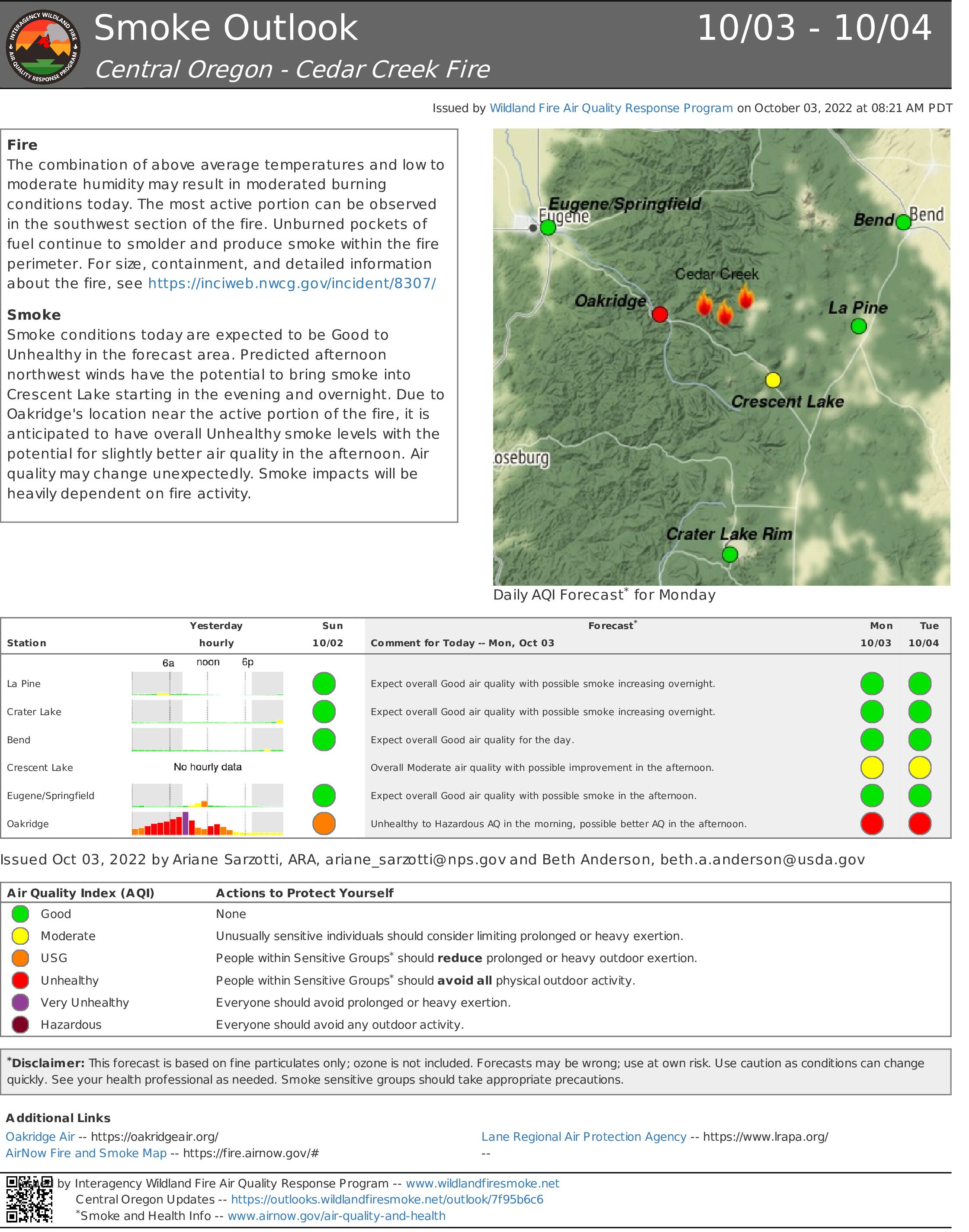
Cedar Creek Fire Update October 3 2022
Related Incident: Cedar Creek Fire
Publication Type: News
Cedar Creek Fire
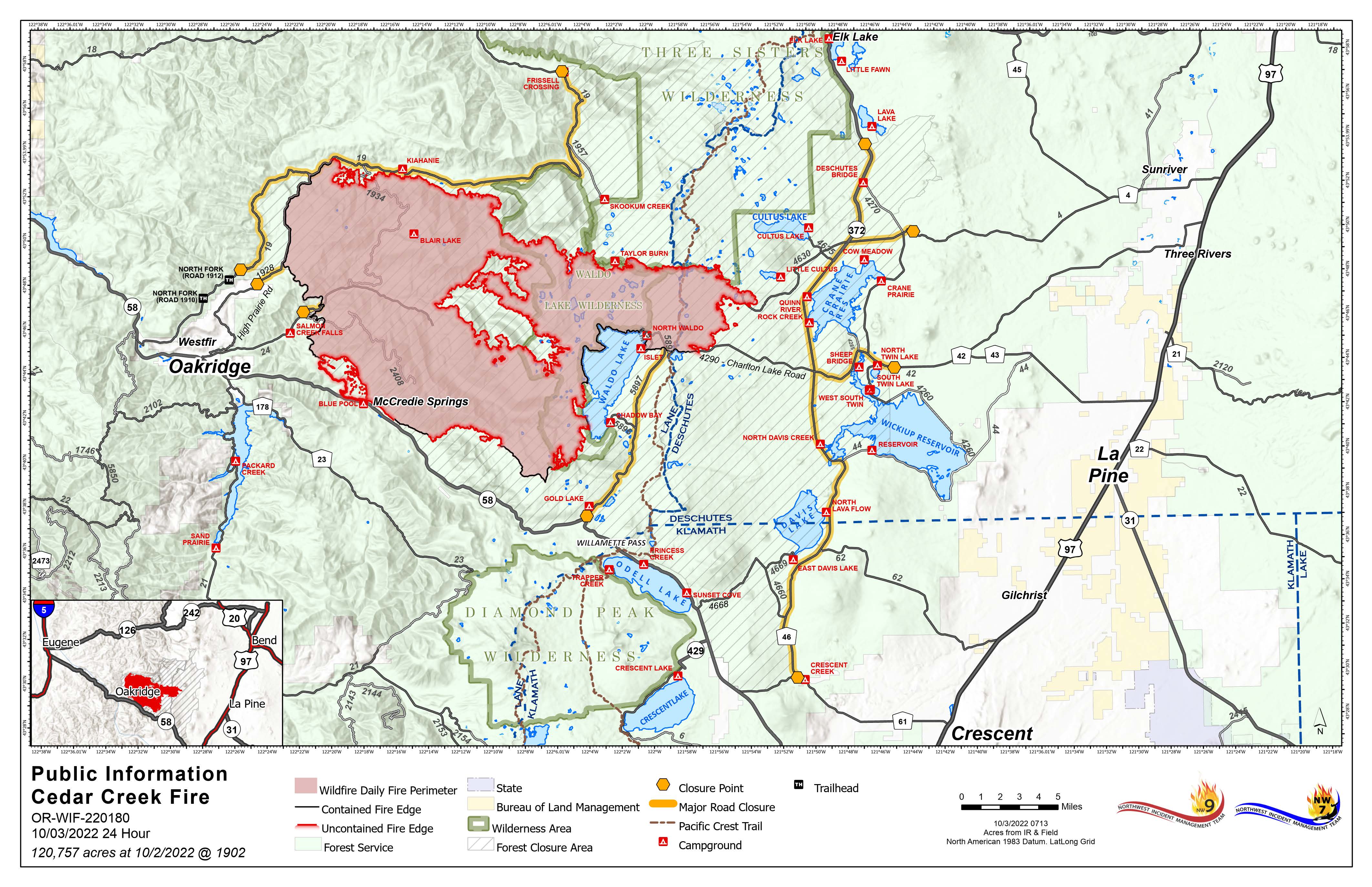
October 3, 2022 | Update 8:30 AM | Size: 120,575 acres | Contained: 32% | Start Date: August 1,2022 | Origin: 15 miles east of Oakridge, OR
Cause: Lightning | Total personnel: 896 | Resources: 17 engines; 14 crews; 17 heavy equipment; 7 helicopters
A Burned Area Emergency Response (BAER) team has arrived to the Cedar Creek Fire to assess post-fire rehabilitation and recovery. The BAER team will be working across both zones of the fire. Northwest Incident Management Team 9 is assuming command of the Potter and Big Swamp Fires today.
West Zone Operations: Weather conditions and fire behavior yesterday allowed for strategic firing operations in Division X on the western edge of the fire. These firing operations included the use of a plastic sphere dispenser (PSD) that drops “ping pong” balls injected with flammable materials from the helicopter. These spheres ignite upon impact with the ground to consume unburned fuels between the main body of the fire and established containment lines. Low intensity burning from these operations will help decrease the duration of smoke impacts in the area. Firefighters are working to secure Forest Service Road 2409 to safely access the interior of the north, northwest region of the fire. The south and southwest region of the fire will be undergoing additional clean up along the fire edge with possible firing operations dependent on conditions. Finalized repairs are being conducted on the north edge of the fire along the sides of Forest Service Roads 1958 and 19.
East Zone Operations: Work on the East side of the Cascade Crest yesterday included improvements and repair of indirect containment line, road work, removal of structure protection materials and looking ahead to continue reducing impacts to the area. Today, work along Forest Service Road 46 continues as equipment and crews come closer to completing work on the indirect containment line. In addition to roadside repair, rocking and grading along Forest Service Road 700 near Cultus Lake will progress, as well as berm removal and clearing of culverts that were affected during operations. Temperatures have remained consistently warmer, as predicted, which has resulted in minimal amounts of moisture retention from the precipitation that fell over the fire last week. Fire behavior is expected to continue creeping and smoldering with a small possibility of torching due to drier fuels.
Weather: Continued southeast winds in the morning and northwest winds in the evening will shift smoke away from Oakridge and surrounding communities in the afternoon. Temperatures will remain in the high 70s and 80s for the coming week.
Closures: The Deschutes National Forest and Willamette National Forest both have closures and fire restrictions in effect. Some of these closures will remain in effect until areas that have been heavily impacted by the fire are surveyed for safety hazards. Please respect Forest closures for firefighter and public safety. Violations of these prohibitions are punishable by a fine of not more than $5,000.00 for an individual or $10,000.00 for a corporation or imprisonment for not more than six months or both. 16 USC § 551 and 18 U.S.C §§ 3551, 3559, 3571, and 3581. Please visit Willamette National Forest and Deschutes National Forest for the most recent closure orders and maps. A Temporary Flight Restriction (TFR) is in place. The use of drones is prohibited in the fire area, please make it safe for our firefighters to use aircraft on the fire. Pacific Crest Trail hikers should visit pcta.org for current information.
Smoke: For current conditions, see Fire.airnow.gov, oakridgeair.org, and LRAPA - Today's Current Air Quality. Smoke Forecast Outlooks are available at https://outlooks.wildlandfiresmoke.net/outlook.
Evacuations: An updated map of the evacuation areas is available at www.LaneCountyOR.gov/CedarCreek. Sign-up for emergency mobile alerts by going to oralert.gov. Please check with Lane County Sheriff’s Office at 541-682-4150 and Deschutes County Sheriff’s Office at 541-693-6911 for updates and changes.
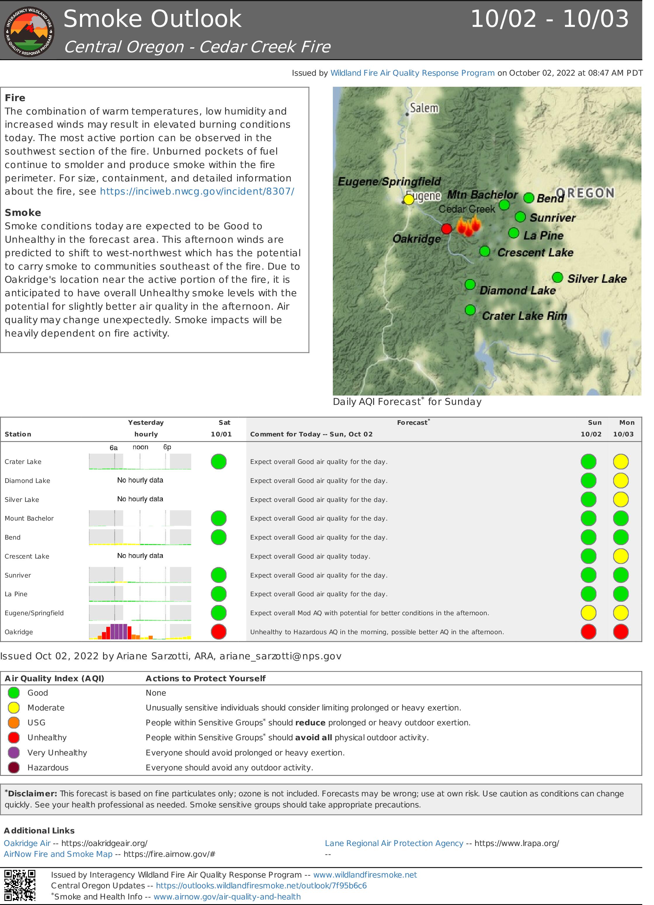
Cedar Creek Fire Update October 2 2022
Related Incident: Cedar Creek Fire
Publication Type: News
Cedar Creek Fire
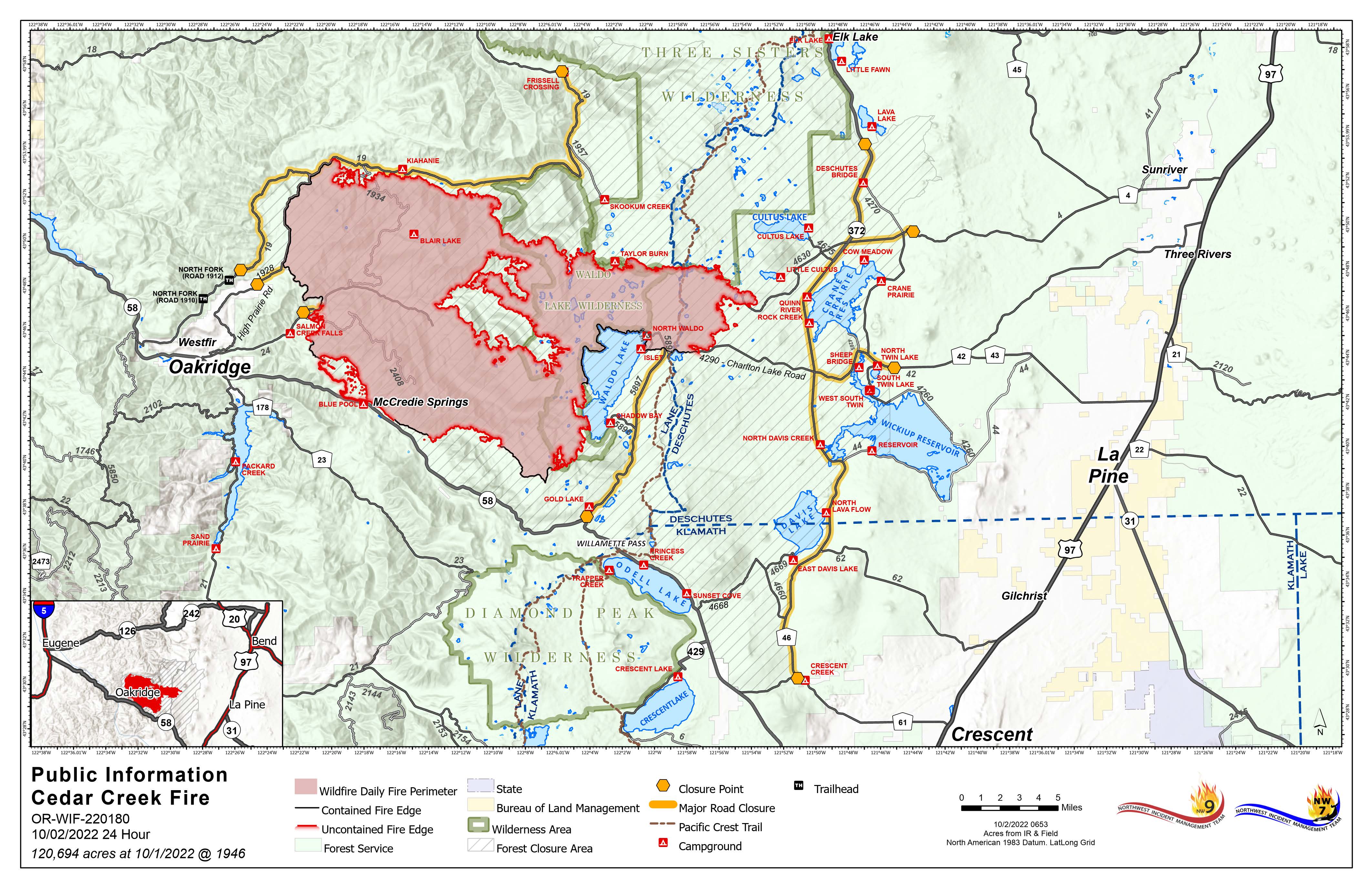
October 2, 2022 | Update 8:30 AM | Size: 120,695 acres | Contained: 27% | Start Date: August 1,2022 | Origin: 15 miles east of Oakridge, OR
Cause: Lightning | Total personnel: 991 | Resources: 21 engines; 18 crews; 17 heavy equipment; 8 helicopters
Deer season opened across the State of Oregon. The Willamette National Forest and the Deschutes National Forest both have closures and fire restrictions in effect for the Cedar Creek Fire. These closures impact hunting units within the fire area and will be enforced.
West Zone Operations: Firefighters were able to remain engaged yesterday as an east wind pushed across the fire area. With the assistance of the Union Pacific Fire Train, crews increased the security of control lines in the south and southwest. The east wind event will continue today but begin to diminish and ultimately shift to a northwest wind by the afternoon and evening. Road grading has begun on the west side of the fire and is expected to continue as crews work to repair areas impacted by firefighting efforts. The southeast area of the fire showed little activity from a reconnaissance flight yesterday afternoon and will continue to be monitored. Work to reduce fuels and repair impacted areas along the northern edge is nearing completion.
East Zone Operations: Yesterday’s work around the divisions east of the crest included processing fuels, skidding, hauling, decking, masticating, and looking ahead to repair work. Some of the road work included identifying areas along the 46 road that need repair and finishing grading along the 700 road near Cultus Lake. Temperatures are unseasonably hotter and drier than normal with no precipitation in the foreseeable forecast. The fire is expected to continue creeping and smoldering, but no spotting is anticipated.
Weather: Temperatures will be rising again today with the continued east winds. Winds will shift to a westerly direction in the afternoon, but temperatures will remain in the high 70s to 80s for the coming week
Closures: The Deschutes National Forest and Willamette National Forest both have closures and fire restrictions in effect. Some of these closures will remain in effect until areas that have been heavily impacted by the fire are surveyed for safety hazards. Please respect Forest closures for firefighter and public safety. Violations of these prohibitions are punishable by a fine of not more than $5,000.00 for an individual or $10,000.00 for a corporation or imprisonment for not more than six months or both. 16 USC § 551 and 18 U.S.C §§ 3551, 3559, 3571, and 3581. Please visit Willamette National Forest and Deschutes National Forest for the most recent closure orders and maps. A Temporary Flight Restriction (TFR) is in place. The use of drones is prohibited in the fire area, please make it safe for our firefighters to use aircraft on the fire. Pacific Crest Trail hikers should visit pcta.org for current information.
Smoke: For current conditions, see Fire.airnow.gov, oakridgeair.org, and LRAPA - Today's Current Air Quality. Smoke Forecast Outlooks are available at https://outlooks.wildlandfiresmoke.net/outlook.
Evacuations: An updated map of the evacuation areas is available at www.LaneCountyOR.gov/CedarCreek. Sign-up for emergency mobile alerts by going to oralert.gov. Please check with Lane County Sheriff’s Office at 541-682-4150 and Deschutes County Sheriff’s Office at 541-693-6911 for updates and changes.
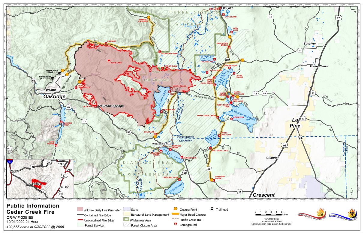
Cedar Creek Fire Update October 1 2022
Related Incident: Cedar Creek Fire
Publication Type: News
Cedar Creek Fire
October 1, 2022 | Update 8:30 AM | Size: 120,655 acres | Contained: 27% | Start Date: August 1,2022 | Origin: 15 miles east of Oakridge, OR
Cause: Lightning | Total personnel: 1,022 | Resources: 28 engines; 18 crews; 19 heavy equipment; 8 helicopters
A shift in wind direction has been contributing to an increase in fire activity and gusts out of the east have pushed smoke from across the fire toward the community of Oakridge and surrounding areas. This east wind is expected to continue and increase over the weekend. Unlike the east wind event several weeks ago that generated extreme fire behavior, this eastly wind is accompanied by cooler temperatures, higher relative humidity, and, thanks to firefighter efforts, a reduced fuel load.
West Zone Operations: Yesterday, crews and heavy equipment continued work to repair areas that have been disturbed by firefighting activities along the northern edge of the fire. A task force of firefighting resources will be engaged along the southwest edge of the fire where there is uncontained fire line that could be tested by wind conditions and rising temperatures. Poor air quality in the Highway 58 corridor, Oakridge and adjacent communities is expected to persist throughout the weekend. Temperature inversions will trap smoke in the valleys and drainages during the morning hours and into the afternoon. For air quality resources, see the links below.
Weather: Increased temperatures and gusting winds out of the east are predicted throughout the weekend. As the warming and drying trend continues, relative humidities will continue to drop. Sunday will remain warm and dry, but winds will begin to diminish and shift to westerly.
Smoke: For current conditions, see Fire.airnow.gov, oakridgeair.org, and LRAPA - Today's Current Air Quality. Smoke Forecast Outlooks are available at https://outlooks.wildlandfiresmoke.net/outlook.
Evacuations: An updated map of the evacuation areas is available at www.LaneCountyOR.gov/CedarCreek. Sign-up for emergency mobile alerts by going to oralert.gov. Please check with Lane County Sheriff’s Office at 541-682-4150 and Deschutes County Sheriff’s Office at 541-693-6911 for updates and changes.
Actualizacion Diaria Incendio Cedar Creek Septiembre 30 2022
Related Incident: Cedar Creek Fire
Publication Type: News
Resumen del Incendio Cedar Creek
Operaciones en la Zona Este: La actividad del incendio ha disminuido debido al reciente enfriamiento en las condiciones climáticas. Con la presencia de temperaturas calientes y el material de combustión seco, se espera volver a experimentar humo, pero un mínimo crecimiento y una actividad baja en el incendio. El día de ayer, se experimentó un clima inclemente obstruyendo las operaciones de vuelos sobre el incendio. Sin embargo, el día de hoy, se realizarán dichas operaciones tan pronto como las condiciones climáticas lo permitan. Los cuerpos de bomberos se encuentran muy ocupados tratando de reducir grandes cantidades de material de combustión a través de procesos de astillado, masticando la madera y removiendo arbustos. Además, los bomberos estuvieron trabajando fuertemente en la limpieza, moviendo equipos a otras zonas y trabajando en las carreteras. El área de Cascade Lakes Scenic Byway/Route 46, permanece cerrada desde el Norte de Lava Lake hasta el Sur de Crescent Cutoff Road. El Highway 58 se encuentra abierto para el público. Sin embargo, las operaciones de pavimentación realizadas por el Departamento de Transporte de Oregon, podrían causar algún retraso en el tráfico. Por favor respete las ordenes de cierre de caminos. Las personas que hacen caso omiso a estas prohibiciones serán multadas con $5,000.00 por persona o $10,000.00 para las corporaciones, o en otros casos, serán encarceladas por no mas de seis meses o también pueden multados y encarcelados.
Condiciones climáticas: Una tendencia del clima significativamente caliente y seca se presentará a partir del viernes con ráfagas de vientos provenientes del Este y afectando el área del incendio. Se espera un clima presentando brisas calientes y secas a partir del viernes permaneciendo el fin de semana con las posibilidades de presentar una combinación pesada de viento y baja humedad para el sábado.
Cierres de caminos: Los Bosques Nacionales de Deschutes y Willamette, han dictado ordenes de cierres de camino. Algunas de estas áreas permanecerán cerradas hasta que se haya realizado un estudio del peligro en las zonas que han sido fuertemente impactadas por el incendio. Para información actual y mapas, visite Willamette National Forest y Deschutes National Forest. El Puesto para el Comando de Incidente se ha establecido en el parque industrial en Oakridge con un campamento para los bomberos que se encuentran cerca de Hill Creek Dam el cual está siendo utilizado por los bomberos y se encuentra cerrado para el público. Se emitió una orden temporal de vuelos sobre la zona la cual se conoce como como Temporary Flight Restriction (TFR). El uso de drones está prohibido en el área afectada, por favor colabore para asegurar la vida de nuestros bomberos que están ayudándose con métodos aéreos en el incendio. Para información actualizada acerca del sendero Pacific Crest, visite pcta.org.
Evacuaciones: Un mapa actualizado acerca de las evacuaciones locales, está disponibles en www.LaneCountyOR.gov/CedarCreek. Puede registrarse para recibir alertas móviles de emergencia visitando oralert.gov. Para información actualizada y cambios en relación al incendio, por favor chequee la Lane County Sheriff’s Office al 541-682-4150 y la oficina del Alguacil de la ciudad de Deschutes (Deschutes County Sheriff’s Office) llamando al 541-693-6911.
Online: https://inciweb.nwcg.gov/incident/8307/ | www.facebook.com/CedarCreekFire2022/ www.tinyurl.com/cedarcreekfireyoutube | Fire Information Line: 541-201-2335, 8:00 AM – 8:00 PM | For Media Inquiries: 541-327-9925 | Email: 2022.cedarcreek@firenet.gov
Cedar Creek Fire Update September 30 2022
Related Incident: Cedar Creek Fire
Publication Type: News
Cedar Creek Fire
September 30, 2022 | Update 8:30 AM | Size: 120,546 acres | Contained: 27% | Start Date: August 1, 2022 | Origin: 15 miles east of Oakridge, OR | Cause: Lightning | Total personnel: 1,252 | Resources: 33 engines; 26 crews; 27 heavy equipment; 9 helicopters
West Zone Operations: Work continued yesterday to secure fire perimeter nearest to the communities of Oakridge, Westfir, and High Prairie ahead of anticipated weather that could challenge containment lines. A taskforce of engines, crews, and equipment will be arriving ahead of a new weather system pushing in from the east to aid in this work and reinforce containment lines along the southwestern edge. With the change in weather, smoke is expected to impact surrounding communities beginning today and continue over the next few days. As containment increases, efforts will be shifted toward assessing damage from the fire and repair work across the fire area. Many areas must be cleared of hazards before recreation sites and trails can safely reopen. The work to assess and accomplish this workload will be ongoing for some time.
East Zone Operations: Due to recent cooler and wetter conditions, fire activity has been minimal. As temperatures warm and fuels dry, the fire is expected to resume smoldering, but little activity or growth is expected. Although inclement weather prevented aircraft from flying yesterday, air support may take place today as weather permits. Ground crews remained busy reducing fuel loads by chipping, masticating, and removing brush. Crews were also active cleaning up, relocating equipment, and road grading. Cascade Lakes Scenic Byway/Route 46 remains closed from Lava Lake in the north to Crescent Cutoff Road in the south. Highway 58 is open; however, Oregon Department of Transportation paving operations may cause delays. Please respect Forest closures. Violations of these prohibitions are punishable by a fine of not more than $5,000.00 for an individual or $10,000.00 for a corporation or imprisonment for not more than six months or both. 16 USC § 551 and 18 U.S.C §§ 3551, 3559, 3571, and 3581.
Weather: A significant warming and drying trend begins Friday as gusty east winds develop over the fire. Warm, dry, breezy weather is expected from Friday through the weekend with the potentially most challenging combination of wind and low humidity occurring Saturday.
Closures: The Deschutes National Forest and Willamette National Forest both have closures and fire restrictions in effect. Some of these closures will remain in effect until areas that have been heavily impacted by the fire are surveyed for safety hazards. Please visit Willamette National Forest and Deschutes National Forest for the most recent closure orders and maps. The Incident Command Post has been established at the industrial park in Oakridge along with a camping area for firefighters near the Hills Creek Dam. This area is in use by firefighters and closed to the public. A Temporary Flight Restriction (TFR) is in place. The use of drones is prohibited in the fire area, please make it safe for our firefighters to use aircraft on the fire. Pacific Crest Trail hikers should visit pcta.org for current information.
Smoke: For current conditions, see Fire.airnow.gov, oakridgeair.org, and LRAPA - Today's Current Air Quality. Smoke Forecast Outlooks are available at https://outlooks.wildlandfiresmoke.net/outlook.
Evacuations: An updated map of the evacuation areas is available at www.LaneCountyOR.gov/CedarCreek. Sign-up for emergency mobile alerts by going to oralert.gov. Please check with Lane County Sheriff’s Office at 541-682-4150 and Deschutes County Sheriff’s Office at 541-693-6911 for updates and changes.
Online: https://inciweb.nwcg.gov/incident/8307/ | www.facebook.com/CedarCreekFire2022/ www.tinyurl.com/cedarcreekfireyoutube | Fire Information Line: 541-201-2335, 8:00 AM – 8:00 PM | For Media Inquiries: 541-327-9925 | Email: 2022.cedarcreek@firenet.gov
Actualizacion Diaria Incendio Cedar Creek Septiembre 29 2022
Related Incident: Cedar Creek Fire
Publication Type: News
Resumen del Incendio Cedar Creek
Operaciones en la Zona Oeste:
El día de ayer, debido al enfriamiento de las temperaturas y lluvias ligeras, la actividad del incendio bajo su intensidad sobre el área. Ese día, las jornadas de limpieza, astillado y patrullaje en el incendio fueron las tareas primordiales sobre los limites noreste y oeste del Incendio las cuales se continuarán el día de hoy. A través de igniciones de incendio realizadas a través del uso de drones, se completaron las operaciones de quema controlada que fueron iniciadas el lunes en la parte suroeste del fuego. En los próximos días, los bomberos seguirán buscando oportunidades para continuar utilizando drones y así solidificar las funciones de control. Las áreas del sureste cercana a Fuji Mountain y Waldo Lake pudieron observar un crecimiento mínimo del incendio por lo tanto se continuará monitoreando a través de vuelos. Nuevamente, esta mañana, se espera una reducción en la visibilidad en el Highway 58 debido a la presencia del humo. La poca visibilidad, carreteras mojadas y los trabajos de camino, representan un incremento en el peligro para la seguridad publica y de los bomberos.
Esta noche, 29 de septiembre, se estará llevando a cabo una reunión comunitaria las 6:00 de la tarde en Greenwaters Park, Oakridge. Se estará trasmitiendo en vivo a través de la página Facebook del Incendio Cedar Creek.
Operaciones en la Zona Este:
El fuego localizado en el lado Este del incendio, continúa humeando y se espera una disminución en la actividad de este debido a la posibilidad de lluvias el día de hoy. Tampoco se espera un crecimiento en el perímetro del fuego. Los bomberos continúan en la construcción de corta fuegos sombreadas y a lo largo de Cascade Lakes Scenic Byway/Route 46, enfocándose en la sección noroeste de la carretera en el reservorio Wickiup (Wickiup Reservoir) y al sur de Lava Lake. Así mismo, con la ayuda de maquinaria masticadora, los bomberos están profundizándose dentro de los corta fuegos a lo largo de la carretera 700 cerca de Cultus Mountain. El área de Cascade Lakes Scenic Byway/Route 46, permanece cerrada desde el Norte de Lava Lake hasta el Sur de Crescent Cutoff Road. El Highway 58 se encuentra abierto para el público. Sin embargo, las operaciones de pavimentación realizadas por el Departamento de Transporte de Oregon, podrían causar algún retraso en el tráfico.
Condiciones Climáticas:
El día de hoy podría iniciarse la presencia de un viento Este, que posiblemente se mantendrá en el área hasta el domingo. Ese evento dará como resultado una baja humedad relativa y un incremento en las temperaturas. Al extremo del área, los vientos podrían incrementarse de 20 a 25 mph, sin embargo, se espera que el comportamiento del incendio se mantenga igual.
Cierres de caminos:
Los Bosques Nacionales de Deschutes y Willamette, han dictado ordenes de cierres de camino. Algunas de estas áreas permanecerán cerradas hasta que se haya realizado un estudio del peligro en las zonas que han sido fuertemente impactadas por el incendio. Para información actual y mapas, visite Willamette National Forest y Deschutes National Forest. El Puesto para el Comando de Incidente se ha establecido en el parque industrial en Oakridge con un campamento para los bomberos que se encuentran cerca de Hill Creek Dam el cual está siendo utilizado por los bomberos y se encuentra cerrado para el público. Se emitió una orden temporal de vuelos sobre la zona la cual se conoce como como Temporary Flight Restriction (TFR). El uso de drones está prohibido en el área afectada, por favor colabore para asegurar la vida de nuestros bomberos que están ayudándose con métodos aéreos en el incendio. Para información actualizada acerca del sendero Pacific Crest, visite pcta.org.
Condiciones del Humo:
Evacuaciones:
Online: https://inciweb.nwcg.gov/incident/8307/ | www.facebook.com/CedarCreekFire2022/ www.tinyurl.com/cedarcreekfireyoutube | Fire Information Line: 541-201-2335, 8:00 AM – 8:00 PM | For Media Inquiries: 541-327-9925 | Email: 2022.cedarcreek@firenet.gov
Cedar Creek Fire Update September 29 2022
Related Incident: Cedar Creek Fire
Publication Type: News
September 29, 2022 | Update 8:30 AM | Size: 115,428 acres | Contained: 25% | Start Date: August 1, 2022 | Origin: 15 miles east of Oakridge, OR | Cause: Lightning | Total personnel: 1,272 | Resources: 31 engines; 29 crews; 27 heavy equipment; 9 helicopters
West Zone Operations: Fire activity slowed yesterday as cooler temperatures and light precipitation influenced the fire area. Mop-up, chipping, and patrol were the tasks of the day on the northern and western ends of the fire and will continue today. Ignitions from an Unmanned Aircraft System (UAS or drone) completed firing operations that began Monday on the southwest part of the fire. Firefighters will look for opportunities in the coming days to utilize the UAS and solidify control features. The southeast area near Fuji Mountain and Waldo Lake saw very minimal fire growth and will be monitored by aircraft. Highway 58 is expected to have reduced visibility due to smoke again this morning. Low visibility, wet roadways, and road maintenance combined pose an increased hazard to the public and firefighters. A community meeting will be held tonight, September 29 in Greenwaters Park, Oakridge at 6:00 PM, and live streamed on the Cedar Creek Fire Facebook page.
East Zone Operations: The fire on the East Side continues to smolder, with the potential for rain likely to further limit fire behavior today. No new perimeter growth is expected. Firefighters are continuing work on the shaded fuel breaks along Cascade Lakes Scenic Byway/Route 46, focusing on the roadway northwest of Wickiup Reservoir and just south of Lava Lake. They are also using masticators to add more depth to the fuel break along the 700 Road near Cultus Mountain. Cascade Lakes Scenic Byway/Route 46 remains closed from Lava Lake in the north to Crescent Cutoff Road in the South. Highway 58 is open; however, Oregon Department of Transportation paving operations may cause delays.
Weather: An east wind event will begin today and is expected to continue through Sunday resulting in lower relative humidity and increased temperatures. Winds on ridges could increase to 20-25 mph, but concerns remain low for increased fire behavior.
Closures: The Deschutes National Forest and Willamette National Forest both have closures and fire restrictions in effect. Some of these closures will remain in effect until areas that have been heavily impacted by the fire are surveyed for safety hazards. Please visit Willamette National Forest and Deschutes National Forest for the most recent closure orders and maps. The Incident Command Post has been established at the industrial park in Oakridge along with a camping area for firefighters near the Hills Creek Dam. This area is in use by firefighters and closed to the public. A Temporary Flight Restriction (TFR) is in place. The use of drones is prohibited in the fire area, please make it safe for our firefighters to use aircraft on the fire. Pacific Crest Trail hikers should visit pcta.org for current information.
Smoke: For current conditions, see Fire.airnow.gov, oakridgeair.org, and LRAPA - Today's Current Air Quality. Smoke Forecast Outlooks are available at https://outlooks.wildlandfiresmoke.net/outlook.
Evacuations: An updated map of the evacuation areas is available at www.LaneCountyOR.gov/CedarCreek. Sign-up for emergency mobile alerts by going to oralert.gov. Please check with Lane County Sheriff’s Office at 541-682-4150 and Deschutes County Sheriff’s Office at 541-693-6911 for updates and changes.
Online: https://inciweb.nwcg.gov/incident/8307/ | www.facebook.com/CedarCreekFire2022/ www.tinyurl.com/cedarcreekfireyoutube | Fire Information Line: 541-201-2335, 8:00 AM – 8:00 PM | For Media Inquiries: 541-327-9925 | Email: 2022.cedarcreek@firenet.gov