
White River Irving Peak and Minnow Ridge Weekly Fire Update 9282022
Related Incident: White River (& Irving Peak)
Publication Type: News
White River, Irving Peak, and Minnow Ridge Fires
Fire Information Line: 509-557-0973
September 28, 2022 8:00AM
Fire updates will be occurring about once a week, or as conditions change.
Operations on the White River and Irving Peak Fires: Over the past several days the Irving Peak and White River fires experienced minimal fire growth. The fires have been burning in close proximity to each other and have merged into one fire. The fire has slowly moved downhill to meet containment lines and road systems in the area.
Along the western perimeter in the Little Wenatchee drainage, a few spot fires occurred due to large burning logs rolling down the steep terrain. Crews were able to get access to the spot fires in the bottom of the drainage and contain them, preventing the fire from crossing the Little Wenatchee River.
Another spot fire on the southeast corner was located across White River on a peninsula where the river meanders. This and a few other small spot fires were contained by firefighters over the past few days.
Helicopters have been used for water drops as needed to assist in controlling spot fires and keeping the fire in check including the area above Windmill Lane.
A Burned Area Emergency Response Team arrived on September 26 to complete initial assessments of post-fire conditions and determine the need for additional emergency stabilization actions to prevent loss of life and property and critical and natural resources.
Additional suppression repair work will continue on the Irving Peak side of the fire including chipping, repairing culverts, road surfacing, and identifying material that needs to be dispersed to prevent erosion and watershed damage.
Due to the increase in suppression repair activities in the coming days, the public can expect to see more vehicles and heavy equipment traffic on the White River Road #6400 and Chiwawa River Road #6200.
Operations on the Minnow Fire: The Minnow fire has had moderate growth with the most activity on the east-northeast perimeter in the Marble Creek area. The western edge has not crossed Chickamin Creek.
Closures: Fire closure orders remain in place with the following new additions: Trail 1409 (Mad River Trail) between Marble Meadow and Blue Creek Cabin. Trail 1426 (Blue Creek Trail) between Marble Meadow and intersection with Trail 1425 (North Tommy).
Trail 1426 (Blue Creek Trail) will remain OPEN between Blue Creek Cabin and Trial 1425 (North Tommy).
Evacuation levels: All evacuations have been reduced to a level 1.
Smoke Update
Related Incident: White River (& Irving Peak)
Publication Type: News
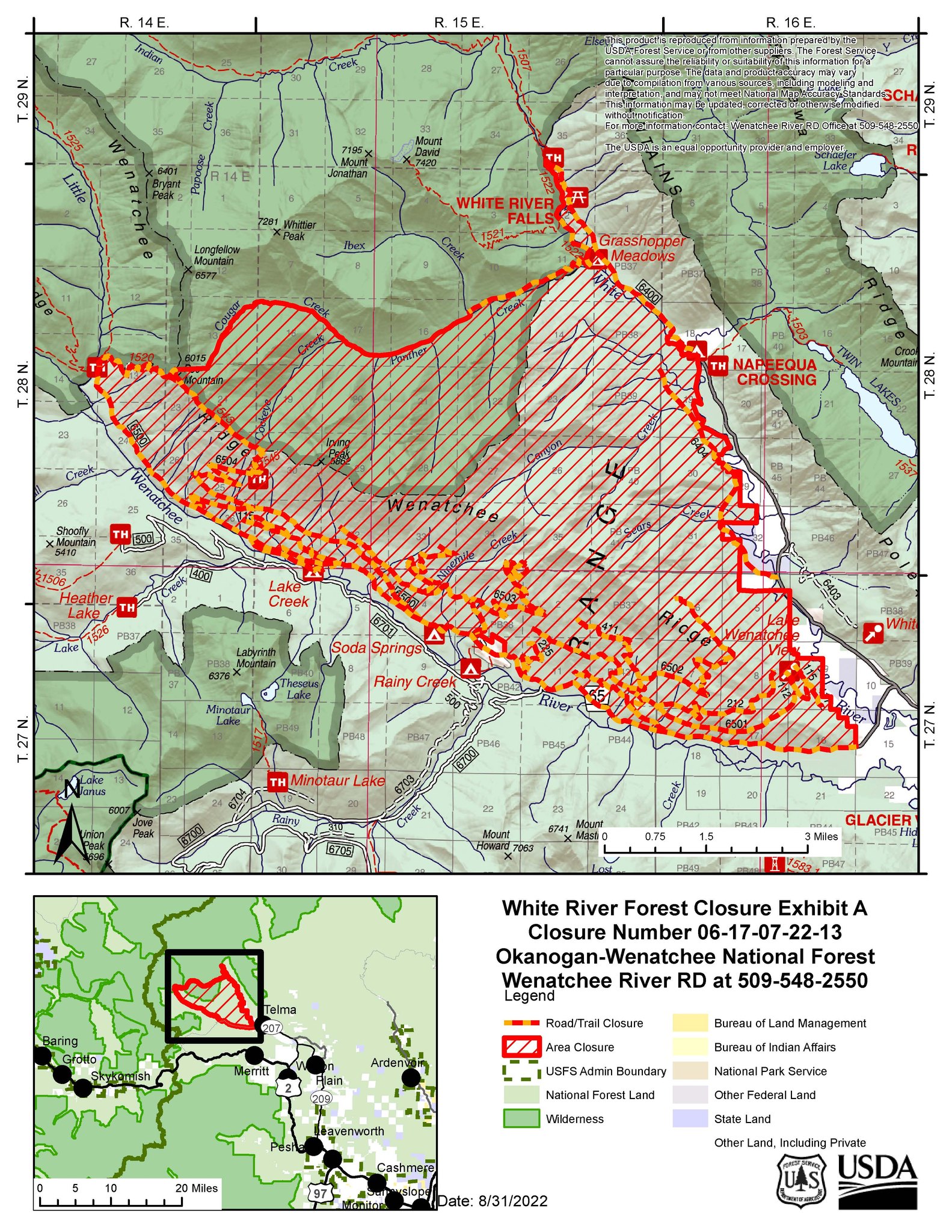
White River Irving Peak and Minnow Ridge Fires Closure Orders
Related Incident: White River (& Irving Peak)
Publication Type: Closures
There are two closure orders for the White River/Irving Peak Fires and the Minnow Ridge Fire. Please view the links below for the respective closure order.
Brief fire update on 9212022
Related Incident: White River (& Irving Peak)
Publication Type: News
We have been getting lots of calls about the smoke impacting local communities from the White River, Irving Peak and Minnow Ridge fires burning 14-16 miles north and northwest of Plain, WA.
White River Irving Peaks Fire Update MONDAY SEPTEMBER 19TH
Related Incident: White River (& Irving Peak)
Publication Type: News
White River & Irving Peaks Fire Update MONDAY SEPTEMBER 19TH
Fire updates will be occurring about once a week, or as conditions change.
According to the latest infrared map showing where heat is present, the White River Fire is ¼ mile from the Windmill Lane cabins on Windmill Lane. The fire is slowly backing downhill towards the road. Firefighting resources are trying to clean up the fuels between the fire’s edge and their containment lines, but the weather hasn’t allowed them to do much of that recently.
Only about 2/100 of an inch of rain has fallen in the fire area over the past two weeks. The relative humidity has increased with the recent storm fronts, but the warming and drying trend this week will cause fire activity to increase as fuels dry out. Fires may be a little more active this week due to warmer temperatures.
White River Fire: 3,373 acres 10% contained
Irving Peak Fire: 3,407 acres 7% contained
Meander Fire: 9 acres 0% contained
Minnow Fire: 650 acres 0% contained
Crews are continuing to utilize firelines from past fires and have set management action points. The Minnow Fire will be putting up more smoke this week as it burns out pockets of timber, then it will die down as it makes short runs into rocky areas. The good news is that it is getting shaded out earlier in the day as the hours of daylight diminish.
Smoke: We may see smoke settling into valleys this week due to the warmer temperatures and due to less winds carrying the smoke out of the area. Smoke from Minnow Ridge Fire was visible from Beaver Hill on Sunday. We anticipate that the Minnow Ridge Fire will be the most active with the warm and dry weather this week.
Weather: Hotter and dryer weather is expected. There was no lightning over the area on Saturday, the storms mainly affected Chelan and Entiat Ranger Districts northeast of the fire area.
Closures: No changes in closures. Trail and road closures remain in effect.
Evacuation levels: A Level 2 evacuation remains in effect for White River Road 6400
Area Closure Lifted September 24 2022
Related Incident: Indian Ridge
Publication Type: News
Good news! The area closure has been lifted on the Indian Ridge Fire on the West Fork Ranger District in Idaho's Selway Bitterroot Wilderness.
There were 12 wildfires this summer in the Wilderness areas on the West Fork District. If you are planning to venture into these areas this fall please know where the fires are and their proximity to you.
Stay aware of conditions on the ground and give the West Fork Ranger District a call at (406) 821-3269 before you come out to check on current conditions or any new closures.
Fire Restrictions Lifted and Fire Danger Lowered
Related Incident: Indian Ridge
Publication Type: Announcement
Hamilton, MT, September 19- Due to recent precipitation and cooler temperatures, the Bitterroot National Forest has lowered its fire danger to “High” down from “Extreme.”
The Forest is also lifting Stage 2 Fire Restrictions effective immediately. Restrictions have been in place since August 12th. This means campfires will again be allowed on the Forest and will also lift the restrictions (hoot owl) on firewood cutting in the afternoon.
Open burning is currently prohibited in Ravalli County. Camp and cooking fires are still allowed. For the latest on current fire restrictions and County burn bans in place throughout Montana visit www.mtfireinfo.org.
Although fire danger remains High, fire management officials opted to move out of restrictions because of the recent precipitation as well as fire danger indices (burning conditions/severity), which are also moving downward as the summer season moves into the summer/fall transition.
Many locations across the forest received precipitation within the last week with totals ranging from a ¼ to nearly 1 inch. Temperatures this week will remain near normal, and a southwest flow will develop that is forecast to bring additional chances of precipitation Wednesday night and Thursday along with potential thunderstorms.
The Magruder Road Corridor between Darby MT. and Elk City, ID. is now open after the Forest lifted the road closure last week from the Twist Creek Fire. The Hog Trough Fire area closure up Skalkaho on the Darby Ranger District was also lifted this weekend. Please note, the Indian Ridge Fire area closure on the West Fork Ranger District remains in place https://inciweb.nwcg.gov/incident/8319/
While fire danger has lessened, fire season is not over. Although campfires can be one of the best parts of camping and provide necessary warmth to hunters and other outdoor enthusiasts, they can also spark wildfires. Please don’t forget your responsibility to maintain and extinguish all campfires. Remember, if it’s too hot to touch, it’s too hot to leave. Never leave a campfire unattended.
This summer, there have been 63 wildfires on the Bitterroot National Forest; 11 human-caused and 52 lightning firesSix Rivers National Forest Order NO 221008
Related Incident: Six Rivers Lightning Complex
Publication Type: Closures
Pursuant to 16 U.S.C. § 551 and 36 C.F.R. § 261.50(a) and (b), and to provide for public safety, the following acts are prohibited within the Lower Trinity Ranger District of the Six Rivers National Forest. This Order is effective from October 1st, 2022, through October 31st, 2022.
- Going into or being upon National Forest System lands within the SRF Lightning Complex Closure Area, as described in Exhibit A and shown on Exhibit C. 36 C.F.R. § 261.52(e).
- Being on any National Forest System Road within the SRF Lightning Complex Closure Area, as listed in Exhibit B and shown on Exhibit C. 36 C.F.R. § 261.54(e).
- Being on any National Forest System trail within the SRF Lightning Complex Closure Area, as listed in Exhibit B and shown on Exhibit C. 36 C.F.R. 261.55(a).
- Entering or using any of portion of Horse Linto Campground or Happy Camp Campground. 36 C.F.R. § 261.58(b).
Pursuant to 36 C.F.R. § 261.50(e), the following persons are exempt from this Order:
- Persons with Forest Service Permit No. FS-7700-48 (Permit for Use of Roads, Trails, or Areas Restricted by Regulation or Order), specifically exempting them from this Order.
- Any Federal, State, or local officer, or member of an organized rescue or fire-fighting force in the performance of an official duty.
- Owners or lessees of land in the area to the extent necessary to access their land.4.Residents, to the extent necessary to access their residences.
These prohibitions are in addition to the general prohibitions contained in 36 C.F.R. Part 261, Subpart A.A violation of these prohibitions is punishable by a fine of not more than $5,000 for an individual or $10,000 for an organization, or imprisonment for not more than six months, or both. 16 U.S.C. 8 U.S.C. §§ 3559, 3571, and 3581.
Executed at Eureka, California this 30th of September 2022.KARI OTTO Acting Forest Supervisor
This Order supersedes Forest Order No. 22-10-07, executed September 8th, 2022.
Exhibit A
The SRF Lightning Complex Closure Area comprises the fire areas of both the Campbell and Ammon Fires of the SRF Lightning Complex. The closure area is within the Lower Trinity Ranger District of Six Rivers National Forest and generally follows the fire perimeter with some areas outside the perimeter identified as areas of suppression repair with un-mitigated hazards, as shown on Exhibit C (map). The closure area for the Ammon fire encompasses portions of Ammon Ridge, Friday Ridge and Oak Knob while the closure for the Campbell Fire is bounded by the Six Rivers National Forest and Shasta-Trinity National Forest Boundaries in the east, Lone Pine Ridge to the north, the Trinity River to the west and south, following section lines as appropriate. Listed below are townships and sections affected in whole or in part by the closure order.
Ammon:T6N R5E Sections: 18, 19, 30, 31, 20, 29, 32 16, 21, 28, 33T6N R4E Sections: 13, 24, 25, 36T5N R5E Sections: 6, 7, 18, 19, 5, 8, 17, 20, 4, 9, 16, 21, 22, 15, 10, 3T6N R4E Sections: 1, 12, 13, 24, 25, 26, 23, 11, 14
Campbell:T7N R5E Sections: 1, 2, 3, 4, 8, 9, 10, 11, 12, 13, 14, 15, 16, 17, 20, 21, 22, 23, 24, 25, 26, 27, 28, 29, 33, 34, 35, 36T7N R6E Sections: 5, 6, 7, 8, 15, 16, 17, 18, 19, 20, 21, 22, 23, 24, 25, 26, 27, 28, 29, 30, 31, 32, 33, 34, 35, 36T6N R5E Sections: 1, 2, 3, 4, 9, 10, 11, 12, 13, 14, 15T6N R6E Sections: 3, 4, 5, 6, 7, 8, 9, 10, 15, 16, 17, 18
FIRE SUMMARY OCTOBER 11 2022
Related Incident:
Publication Type: News
The Central Idaho Dispatch Zone is at MODERATE Fire Danger
The Salmon-Challis National Forest has had one (1) new fire in the last week. To date, there have been 49 wildfires reported on the Salmon-Challis National Forest. 42 of those reported fires are out.Timber Fire (October 5): The ½ acre fire burning in timber is out. The fire was located approximately 12 miles southwest of Leadore on the Leadore Ranger District.
Patterson Fire (September 29): The lightning fire is estimated at 40 acres. The fire is located approximately 13 miles southeast of May on the Challis-Yankee Fork Ranger District. The fire is burning in subalpine and Douglas fir. The fire is under a combination of a point protection and confine and contain strategies. This strategy focuses operations on protecting valued resources such as structures, natural resources, cultural resources, and other property. Risk to responders and public safety is the number priority for the Patterson Fire.
Horse Fire (September 8): The fire, located approximately 5½ miles northwest of Corn Creek on the North Fork Ranger District in the Frank Church River of No Return Wilderness is estimated at 397 acres. The fire is burning in lodgepole, fir, and snags. The fire is being managed under a point protection strategy. Fire activity is minimal, the fire is smoldering in the interior of the perimeter. The fire can be found on InciWeb at https://inciweb.nwcg.gov/incident/8416/.
Owl Fire (September 8): The fire, located approximately 20 miles west of North Fork on the North Fork Ranger District, is 747 acres. The fire, burning in grass, brush, Douglas fir, and snags is 100% contained. The fire is on InciWeb at https://inciweb.nwcg.gov/incident/8416/.
Norton (August 1): The lightning fire is located approximately seven miles northwest of Lower Loon Creek on the Middle Fork Ranger District in the Frank Church River of No Return Wilderness. The 9,069 acre fire burning in subalpine fir, Douglas fir, sagebrush, and grass is located in steep rugged terrain. Fire activity is minimal, the fire is smoldering. The fire is under a point protection strategy, fire managers are utilizing air resources to determine action points and assess values in the vicinity. Fire managers continue to assess the fire using aircraft. The fire can be found on InciWeb at https://inciweb.nwcg.gov/incident/8308/.
Moose (July 17): The fire is being updated separately and can be found on InciWeb at https://inciweb.nwcg.gov/incident/8249/.
Woodtick (July 14): The lightning fire started as two separate fires approximately six (6) miles west, northwest of Meyers Cove on the Middle Fork Ranger District in the Frank Church River of No Return Wilderness. The 9,598 acre fire burning in timber, grass, and brush is located in steep rugged terrain. Fire activity is minimal, the fire is smoldering. The fire is under a point protection and confine and contain strategies with risk to responders and public safety being the top priority. The fire can be found on InciWeb at https://inciweb.nwcg.gov/incident/8253/.
Wolf Fang Fire (July 13): The lightning fire is located approximately four (4) miles northeast of the confluence of Big Creek and the Middle Fork of the Salmon River in the Frank Church River of No Return Wilderness on the North Fork Ranger District. The 2,082 acre fire burning in spruce and fir is located in steep, rugged terrain. Fire activity is minimal, the fire is smoldering. Risk to responders and public safety are the top priorities for the Wolf Fang Fire. Due to the inaccessibility of the terrain and snag hazards a remote camera and aviation are assessing the fire daily. The fire can be found on InciWeb at https://inciweb.nwcg.gov/incident/8273/.
Weather: High pressure will remain in control all week with warm and dry conditions. A passing system to our east will bring a cold front down from Canada reaching eastern Idaho by midday with partly cloudy skies, cooler temperatures, and another afternoon of breezy winds to around 10 to 20 mph. Skies clear and winds subside this evening with colder near normal temperatures Wednesday morning. A warming trend for temperatures and light winds continue into next week with our next system expected again to pass east of our region for Saturday.
The forest is asking visitors to be aware of the MODERATE fire danger for the Salmon-Challis National Forest. One Less Spark Means One Less Wildfire. Never leave a campfire unattended. Always add water, stir it, and make sure all embers are out. If it’s too hot to touch, it’s too hot to leave!
Nationally, there are 12 uncontained large fires being managed under a full suppression strategy and 69 large fires managed under a strategy other than full suppression.
Visit our website at: www.fs.usda.gov/scnf/, ‘Like Us’ on Facebook @salmonchallisnf, and ‘Follow Us’ on Twitter @salmonchallisnf.
####
FIRE SUMMARY OCTOBER 17 2022
Related Incident:
Publication Type: News
The Central Idaho Dispatch Zone is at HIGH Fire Danger
The Salmon-Challis National Forest has had two (2) new fires in the last week. To date, there have been 51 wildfires reported on the Salmon-Challis National Forest. 45 of those reported fires are out.
Cabin (October 16): The one (1) acre fire is located approximately 18 miles southeast of Mackay on the Lost River Ranger District. The fire is burning in spruce and fir. 10 firefighters and helicopters are on scene working to suppress the fire. These resources are being shared with the Cedarville Fire as the two fires are approximately ½ miles apart. The fire is likely human caused.
Cedarville Fire (October 16): The one (1) acre fire is located approximately 18 miles southeast of Mackay on the Lost River Ranger District. The fire is burning in spruce and fir. 10 firefighters and helicopters are on scene working to suppress the fire. These resources are being shared with the Cabin Fire as the two fires are approximately ½ miles apart. The fire is likely human caused.
Patterson Fire (September 29): The lightning fire is estimated at 100 acres. The fire is located approximately 13 miles southeast of May on the Challis-Yankee Fork Ranger District. The fire is burning in subalpine and Douglas fir. The fire is under a combination of a point protection and confine and contain strategies. This strategy focuses operations on protecting valued resources such as structures, natural resources, cultural resources, and other property. Risk to responders and public safety is the number priority for the Patterson Fire.
Horse Fire (September 8): The 397 acre fire was located approximately 5½ miles northwest of Corn Creek on the North Fork Ranger District in the Frank Church River of No Return Wilderness. The fire is burning in lodgepole, fir, and snags is out.
Owl Fire (September 8): The 747 acre fire was located approximately 20 miles west of North Fork on the North Fork Ranger District. The fire, burning in grass, brush, Douglas fir, and snags is out.
Norton (August 1): The lightning fire is located approximately seven miles northwest of Lower Loon Creek on the Middle Fork Ranger District in the Frank Church River of No Return Wilderness. The 9,069 acre fire burning in subalpine fir, Douglas fir, sagebrush, and grass is located in steep rugged terrain. Fire activity is minimal, the fire is smoldering. The fire is under a point protection strategy, fire managers are utilizing air resources to determine action points and assess values in the vicinity. Fire managers continue to assess the fire using aircraft. The fire can be found on InciWeb at https://inciweb.nwcg.gov/incident/8308/.
Moose (July 17): Friday saw a slight increase in a one acre area high within the watershed in Jesse Creek where fire climbed into the trees and torched out a ½ to 1 acre area. Saturday, Sunday, and today, fire activity was minimal. The fire continues to creep and smolder on the ground, consuming concentrations of ground fuels. This fire activity is reducing the potential for extreme fire behavior and moderate high to severe burn intensity in the coming years. Fire managers are currently balancing the risk to responders, in the steep, rugged, thickly wooded forest, which is difficult to access with threats to the Municipal Watershed. Crews are engaging the fire where it is safe to do so and are falling trees along the Ridge and Stormy Peak roads where there is potential for trees to fall across the roadway and block access. There has been an inversion over the fire area the last several days. This inversion holds the smoke in the drainages, not allowing it to lift and drift out of the area. An infrared flight has been ordered and new maps will be available after the flight later this week. Ongoing information about the fire can be found on InciWeb at https://inciweb.nwcg.gov/incident/8249/.
Woodtick (July 14): The lightning fire started as two separate fires approximately six (6) miles west, northwest of Meyers Cove on the Middle Fork Ranger District in the Frank Church River of No Return Wilderness. The 9,598 acre fire burning in timber, grass, and brush is located in steep rugged terrain. Fire activity is minimal, the fire is smoldering. The fire is under a point protection and confine and contain strategies with risk to responders and public safety being the top priority. The fire can be found on InciWeb at https://inciweb.nwcg.gov/incident/8253/.
Wolf Fang Fire (July 13): The 2,082 acre lightning fire was located approximately four (4) miles northeast of the confluence of Big Creek and the Middle Fork of the Salmon River in the Frank Church River of No Return Wilderness on the North Fork Ranger District. The fire burning in spruce and fir is located in steep, rugged terrain is out.
Weather: Dry conditions with poor humidity recovery will persist through mid-week, with minimum humidities in the teens. Clear skies will mean unseasonably warm temperatures, with nightly inversions and a slight warming trend. A pattern change will arrive late week, as the ridge breaks down Thursday and a northwest system brings elevated winds, a drastic drop in temperatures, and rain and snow chances this weekend.
The forest is asking visitors to be aware of the HIGH fire danger for the Salmon-Challis National Forest. One Less Spark Means One Less Wildfire. Never leave a campfire unattended. Always add water, stir it, and make sure all embers are out. If it’s too hot to touch, it’s too hot to leave!
Nationally, there are 13 uncontained large fires being managed under a full suppression strategy and 66 large fires managed under a strategy other than full suppression.
Visit our website at: www.fs.usda.gov/scnf/, ‘Like Us’ on Facebook @salmonchallisnf, and ‘Follow Us’ on Twitter @salmonchallisnf.