
Four Corners Fire Update September 21 2022
Related Incident: Four Corners Fire
Publication Type: News
Yesterdays infrared imagery showed in increase in acreage due to interior pockets of fuel burning.
Four Corners Fire Update September 20 2022
Related Incident: Four Corners Fire
Publication Type: News
The next update you see will be released on Monday September 26th, 2022, unless significant changes occur.
Recently the sun has been shining and winds have picked up a little each afternoon. Visible fire activity has increased slightly, but moisture is expected to arrive Wednesday and Thursday. You may see heavy fuels continuing to burn and some visible smoke on the mountain, but the fire activity is generally creeping and smoldering.
Firefighters assigned to the team will continue to respond to new fire starts in the area. Since the teams arrival last week, they have responded to and extinguished 4 lightning caused fires and kept them to about .10-acres in size. Potentially there are lighting struck trees in the area from the recent storms that are smoldering and not visible until the tree dries out after the rainstorm. Firefighters will patrol by ground and air when safe to do so.
Fire personnel continue to make good progress on mop up, repair activities, and preparations to remove un-needed equipment such as hose and pumps off containment lines. At this time excavator suppression repair work is 72% done and about 3.39 miles of dozer line is still existing. Line repair will continue as the equipment is able to progress around the fire perimeter.
Recreators and hunters should also be on the lookout for lighting or human caused fires this time of year. If you find a fire that is outside of the Four Corners Fire perimeter, please take note of where you are with a GPS Lat/Long, good description, and report to the nearest Ranger Station or 911.
Dozer Repair Status: 28% Needs repair; 72% has been completed for a total of 7.56 miles
Hand Line Status: 5% Needs repair; 95% Completed for a total of 14.76 miles
Four Corners Fire Update September 19 2022
Related Incident: Four Corners Fire
Publication Type: News
Very little smoke was visible today, but Infrared flights at night are detecting heat sources in the fire footprint. Despite the cooler weather and rain activity, the fire continues to smolder under the tree canopy, tops of trees, and in the downed logs. It is still fire season, and the dead and live tree species are dry due to the hot summer.
Firefighters in the area have responded to several new lightning fire starts near the Four Corners Fire. Weather has been in their favor, and they have arrived quickly to keep them less than .10 acres. One fire was near Blue lake and the other was on Cold Springs Ridge just north of the Four Corners Fire.
The Burned Area Emergency Rehabilitation Team (BAER) completed their field assessment of the fire and will generate a treatment plan with the data they collected. They studied burn severity of the fire, took soil samples, surveyed roads, trails, and culverts in search of damage that would need repaired.
Dozer Repair Status: 37% Needs repair; 63% has been completed for a total of 7.56 miles
Hand Line Status: 5% Needs repair; 95% has been completed for a total of 14.76 miles
Weather: Monday looks to be a clear sunny day, with temperatures in the high 60s to low 70’s. Winds are expected to be light.
Closure Information: On Sept. 15, the closure perimeter was reduced to allow more access to areas in and around the fire. See map and description at https://InciWeb.nwcg.gov/incident/closures/8331/.
Hunting Information: https://idfg.idaho.gov/blog/2016/08/get-current-fire-information-hereFour Corners Fire Update September 18 2022
Related Incident: Four Corners Fire
Publication Type: News
A crisp late summer day welcomed fire crews Saturday as patrols of containment lines and repair areas progressed. The recent change in forest closure boundaries has encouraged increased recreational traffic in and around the fire perimeter. Motorists are advised to exercise caution because the Four Corners Fire is still an active fire zone.
Please drive slow, watch for road hazards and avoid firefighters, engines and heavy equipment working in the area. Expect some delays up to 30 minutes on the Anderson Creek 435 road while crews remove hazard trees.
Fire managers report that containment lines in the north and east sides are solid and are showing minimal smoking. But despite regular shower activity the rain hasn’t penetrated the tree canopy on much of the east side.
Crews in the Willow Creek drainage reported continued success patrolling, mopping-up and getting more depth interior. Patrols are actively removing snags in the area. These are dead standing trees that can be hazardous to firefighters and the public. The west edge of the fire is stable with little smoke.
For Sunday, suppression repair and patrol will continue across the fire. Also, a Burned Area Emergency Rehabilitation Team (BAER) will continue to assess post-fire conditions for long term recovery. The BAER Team includes natural resource specialists such as hydrologists, biologists, foresters and civil engineers. They analyze the fire’s emergency stabilization needs. They will generate a recovery plan which will be implemented in the coming weeks.
Expect smoke to be visible within the fire perimeter as the fire winds down. Firefighters will continue to monitor the fire area by air and ground and will respond to any fire activity as necessary.
Weather: Sunday will be mostly cloudy with a 30% chance of showers and a slight chance thunderstorms in the afternoon. Temperatures will be in the 60s with calm winds 5-8 mph.
Closure Information: On Sept. 15, the closure perimeter was reduced to allow more access to areas in and around the fire. See map and description at https://InciWeb.nwcg.gov/incident/closures/8331/.
Hunting Information - https://idfg.idaho.gov/blog/2016/08/get-current-fire-information-hereFour Corners Fire Update September 17 2022
Related Incident: Four Corners Fire
Publication Type: News
Fire personnel are seeing many recreationists near the fire since the closure has been reduced in size. Travel on the Anderson Creek 435 road is allowed but fire officials ask that you drive slowly and pay attention to your surroundings, you may encounter short closures if crews need to conduct falling operations. Firefighters will continue to patrol all areas of the fire; looking for hotspots, snags, and trees that can negatively affect the forest roads. As you are out driving be careful of large engines stopped for hazard tree and rock removal.
Today crews will continue to hold and improve existing control lines along their divisions by mopping-up to the extent necessary to prevent fire escape. Four miles of fire hose, pumps and other water handling equipment will remain near poison creek throughout the weekend.
Resources will monitor and patrol fire lines, keeping fire in the existing footprint. Rolling rocks and hazard trees remain an area of concern across the fire and are being addressed where possible. As much of the focus shifts to suppression repair activities; crews will be working closely with the resource advisors, using available equipment to restore the area to the forest standards.
Smoke will continue to be visible within the fire perimeter. Do not call 911. Instead, report fire activity or smoke within the fire perimeter by calling 208-510-8412. Firefighters will continue to monitor the fire area by air and ground and will respond to any fire activity as necessary.
Weather: On Saturday and Sunday expect patchy smoke and a chance of showers and thunderstorms in the afternoons. Expect a 60% chance of precipitation on Sunday.
Air Quality: Specific information about local smoke levels, forecasts, and possible health impacts is available at https://outlooks.airfire.org/outlook/cc0ac676/.
Closure Information: The current closure includes an area around Collier Peak and the fire perimeter. Complete closure order for the Boise and Payette National Forests – including a full description and an accompanying map – is available at https://InciWeb.nwcg.gov/incident/closures/8331/.
Hunting Information - https://idfg.idaho.gov/blog/2016/08/get-current-fire-information-hereWhite River Irving Peak and Minnow Ridge Weekly Fire Update 1052022
Related Incident: White River (& Irving Peak)
Publication Type: News
White River, Irving Peak, and Minnow Ridge Fires
Fire Information Line: 509-557-0973
October 5, 2022 6:00 PM
Fire updates will be occurring about once a week, or as conditions change.
Unseasonably warm and dry conditions, with temperatures about 10 degrees above average, have contributed to a slight increase in fire activity over the past week. As a result of the natural increase in fire activity and lack of wind, the concentration of smoke has also increased.
White River and Irving Peak Fires (9,579 acres): The fire continued to progress toward the FS 6500 and 311 roads on the south and east perimeters. Last week, several spot fires were located across these roads and were successfully contained by fire crews. In order to protect values at risk and prevent unwanted spread of the fire to the south and east across FS 6500 and 311 roads, firefighters implemented tactical firing operations to strengthen the containment lines. The tactical firing operation has taken several days to complete with limited daily ignitions to avoid excess smoke production. The firing operations have been successful in keeping the fire north of FS 6500 road.
A Type 3 Incident Management Team and numerous fire resources including helicopters, multiple engines, handcrews, and an Interagency Hotshot Crew remain engaged in the full suppression effort.
Operations on the Minnow Ridge Fire (2,757 acres): The Minnow Ridge fire has had moderate growth with the most activity on the south-southeast perimeter in the Marble Creek area. The western edge has not crossed Chickamin Creek.
Closures: Fire closure orders remain in place with the following new trail closure additions:
Evacuation levels: All evacuations have been reduced to a level 1.
Brief Fire Update 1022022
Related Incident: White River (& Irving Peak)
Publication Type: News
With temperatures being approximately 10 degrees warmer than average this coming week, fire season is still carrying on into October.
Fire crews are actively engaged in suppressing the White River/Irving Peak fire. Containing spot fires outside of containment lines remains a top priority on the incident. Firefighters are locating and containing spot fires promptly and utilizing helicopters for water drops as necessary. Firefighters have also installed sprinkler systems around structures as a means to protect them from the fire by preventing any embers from establishing spot fires.
Additionally, firefighters will be conducting a firing operation today and tomorrow along the 311 and 6502 roads to reinforce containment lines. This will prevent the unwanted spread of the fire to the west and south. New resources, including an Interagency Hotshot Crew, are arriving to replace those that have reached the end of their 14-day assignment.
People can expect to see increased smoke which will likely drift to the northwest, but some residual smoke may linger in low lying areas.
Closure orders are still in effect and remain unchanged. The Little Wenatchee River Road and others are closed. Closure orders are posted on this site under the 'Closures' tab.
White River Irving Peak and Minnow Ridge Weekly Fire Update 9282022
Related Incident: White River (& Irving Peak)
Publication Type: News
White River, Irving Peak, and Minnow Ridge Fires
Fire Information Line: 509-557-0973
September 28, 2022 8:00AM
Fire updates will be occurring about once a week, or as conditions change.
Operations on the White River and Irving Peak Fires: Over the past several days the Irving Peak and White River fires experienced minimal fire growth. The fires have been burning in close proximity to each other and have merged into one fire. The fire has slowly moved downhill to meet containment lines and road systems in the area.
Along the western perimeter in the Little Wenatchee drainage, a few spot fires occurred due to large burning logs rolling down the steep terrain. Crews were able to get access to the spot fires in the bottom of the drainage and contain them, preventing the fire from crossing the Little Wenatchee River.
Another spot fire on the southeast corner was located across White River on a peninsula where the river meanders. This and a few other small spot fires were contained by firefighters over the past few days.
Helicopters have been used for water drops as needed to assist in controlling spot fires and keeping the fire in check including the area above Windmill Lane.
A Burned Area Emergency Response Team arrived on September 26 to complete initial assessments of post-fire conditions and determine the need for additional emergency stabilization actions to prevent loss of life and property and critical and natural resources.
Additional suppression repair work will continue on the Irving Peak side of the fire including chipping, repairing culverts, road surfacing, and identifying material that needs to be dispersed to prevent erosion and watershed damage.
Due to the increase in suppression repair activities in the coming days, the public can expect to see more vehicles and heavy equipment traffic on the White River Road #6400 and Chiwawa River Road #6200.
Operations on the Minnow Fire: The Minnow fire has had moderate growth with the most activity on the east-northeast perimeter in the Marble Creek area. The western edge has not crossed Chickamin Creek.
Closures: Fire closure orders remain in place with the following new additions: Trail 1409 (Mad River Trail) between Marble Meadow and Blue Creek Cabin. Trail 1426 (Blue Creek Trail) between Marble Meadow and intersection with Trail 1425 (North Tommy).
Trail 1426 (Blue Creek Trail) will remain OPEN between Blue Creek Cabin and Trial 1425 (North Tommy).
Evacuation levels: All evacuations have been reduced to a level 1.
Smoke Update
Related Incident: White River (& Irving Peak)
Publication Type: News
White River Irving Peak and Minnow Ridge Fires Closure Orders
Related Incident: White River (& Irving Peak)
Publication Type: Closures
There are two closure orders for the White River/Irving Peak Fires and the Minnow Ridge Fire. Please view the links below for the respective closure order.
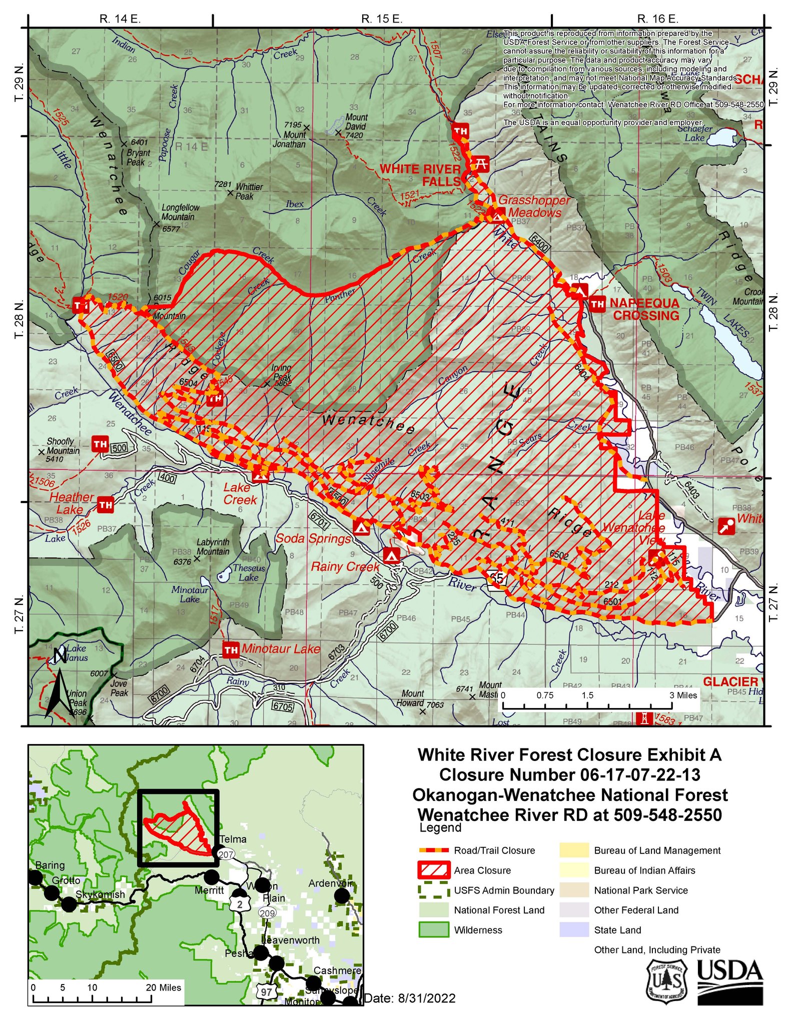