
Cedar Creek Fire Update October 17 2022
Related Incident: Cedar Creek Fire
Publication Type: News
October 17, 2022 | Size: 125,638 acres | Origin: 15 miles E of Oakridge, OR | Containment: 45% | Cause: Lightning | Total personnel: 663 | Resources: 19 engines; 12 crews; 7 helicopters; 9 heavy equipment | Start Date: August 1, 2022
Weather: A shift in fire weather is expected to moderate burning conditions today. The upper-level ridge will shift inland today in response to a couple of in-coming weather disturbances. This will result in cooler temperatures with higher relative humidity. High temperatures will be 8-10 degrees cooler than yesterday with highs mainly in the upper 60s to mid-70s. Relative humidity will be 5-10 percent higher and around 25-35 percent. Winds will be mainly northwest around 10 mph.
Operations: Crews will be holding and securing any areas of remaining heat in areas that saw increased activity with the critical fire weather. Repair and rehabilitation projects continue. Air resources have been heavily engaged in operations whenever it is safe to fly, providing support to firefighters on the ground.
Firefighters on the north end of the fire continue suppression repair on Forest Service Roads 750 and 1944. They are also securing the fire edge on Forest Service Roads 19 and 1938. They will continue to monitor, patrol, and mop up both direct and indirect primary lines. On the east side of the fire, crews are patrolling the 4290 road, completing suppression repair and road grading on the 640 and 4668 to return roads to pre-fire conditions. Chipping operations near Cultus Lake have been completed. To the south, crews are patrolling the 5883 road. They will continue to hold and secure control lines on spot fires. Crews on the western edge of the fire are also patrolling and securing Forest Service Roads including 352 and 353 and securing control line along 5871.
Suppression repairs on the Big Swamp and Potter Fires were completed yesterday.
Closures: There are closures in effect on the Deschutes National Forest and Willamette National Forest. These closures will remain in place until areas impacted by the fire are surveyed for safety risks and fire crews are able to mitigate these hazards. Please respect Forest closures for firefighter and public safety. Please visit Willamette National Forest and Deschutes National Forest for the most recent closure orders and maps. Pacific Crest Trail hikers should visit pcta.org for current information. There is a Temporary Flight Restriction over the Cedar Creek Fire area. Wildfires are a No Drone Zone - if you fly, we can’t.
Smoke: Air quality conditions due to smoke are expected to be Good to Hazardous within the forecast area. Smoke impacts will be heavily dependent on fire activity. For current conditions, see Fire.airnow.gov, oakridgeair.org, and LRAPA - Today's Current Air Quality. Smoke Forecast Outlooks are available at https://outlooks.wildlandfiresmoke.net/outlook.
Evacuations: A map of the evacuation area is available at www.LaneCountyOR.gov/CedarCreek. Sign-up for emergency mobile alerts by going to oralert.gov. Please check with Lane County Sheriff’s Office at 541-682-4150 and Deschutes County Sheriff’s Office at 541-693-6911 for updates and changes.
Online: https://inciweb.nwcg.gov/incident/8307/ | www.facebook.com/CedarCreekFire2022/ www.tinyurl.com/cedarcreekfireyoutube| Fire Information Line: 541-201-2335, 8:00 AM – 8:00 PM | For Media Inquiries: 541-327-9925 | Email: 2022.cedarcreek@firenet.gov
Actualizacion Diaria Incendio Cedar Creek 16 de octubre 2022
Related Incident: Cedar Creek Fire
Publication Type: News
Incendio Cedar Creek
16 de octubre, 2022
Información actualizada
Resumen del Incendio Cedar Creek
Extensión: 124,447 acres
Origen: 15 millas E de Oakridge, OR
Recursos: 19 camiones; 13 Grupos; 7 helicópteros; 8 Maquinaria pesada
Contenido: 45%
Causa: Relámpagos
Personal: 663
Inicio: 1ro agosto, 2022
Se llevará a cabo una reunión para la comunidad el día de hoy, domingo 16 de octubre, a las 4 de la tarde en el Auditorio de la escuela de secundaria de Oakridge. Esta reunión también será transmitida en vivo en Facebook.com/cedarcreekfire2022
Cierres de camino: Se encuentran en efecto órdenes de cierre de caminos y restricciones de incendio para los Bosques Nacionales de Deschutes y Willamette. Estas órdenes permanecerán en pie hasta que se haya realizado un estudio del peligro en las zonas que han sido fuertemente impactadas por el incendio y los bomberos hayan eliminado estos peligros. Por favor respete las ordenes de cierre de caminos para su seguridad y la de los bomberos. Para información actual y mapas, visite: Willamette National Forest y Deschutes National Forest. Se recomienda para los excursionistas en el sendero de Pacific Crest Trail, que visiten pcta.org para mantenerse informados del avance en el incendio. Se emitió una orden temporal de vuelos sobre la zona del Incendio Cedar Creek la cual se conoce como Temporary Flight Restriction. Incendios Forestales No son áreas para el uso de Drones: “Si Usted vuela, nosotros no podemos volar”
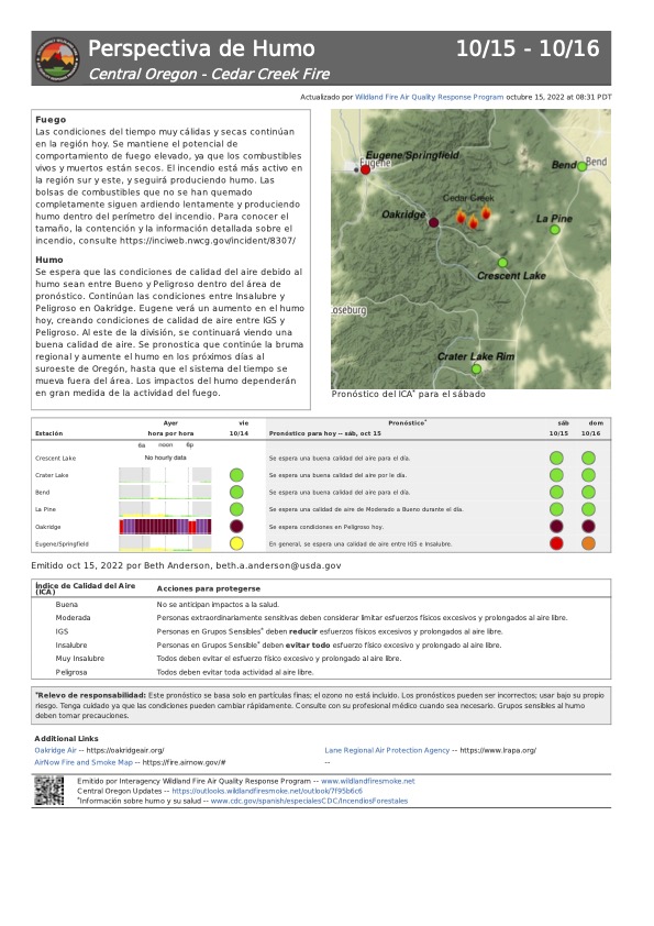
Condiciones del Humo: Debido a la presencia del humo, se esperan condiciones de la calidad del aire entre el rango de Buenas a Insalubres en el pronóstico para esta área. El grado del impacto del humo depende especialmente en la actividad del incendio. Para información actual, lea Fire.airnow.gov, oakridgeair.org, y LRAPA - Today's Current Air Quality. Pronósticos del humo están disponibles en https://outlooks.wildlandfiresmoke.net/outlook
Evacuaciones: Un mapa actualizado acerca de las evacuaciones en la localidad está disponible en www.LaneCountyOR.gov/CedarCreek. Para recibir alertas móviles de emergencias, por favor regístrese en oralert.gov. Por favor, si necesita información actualizada en los cambios dados en el incendio visite, Lane County Sheriff’s Office, 541-682-4150 y Deschutes County Sheriff’s Office, 541-693-6911
Online: https://inciweb.nwcg.gov/incident/8307/ | www.facebook.com/CedarCreekFire2022/ www.tinyurl.com/cedarcreekfireyoutube
| Línea informativa: 541-201-2335, 8:00 AM – 8:00 PM | Para consultas con Medios comunicativos: 541-327-9925 | Email: 2022.cedarcreek@firenet.gov
Cedar Creek Fire Update October 16 2022
Related Incident: Cedar Creek Fire
Publication Type: News
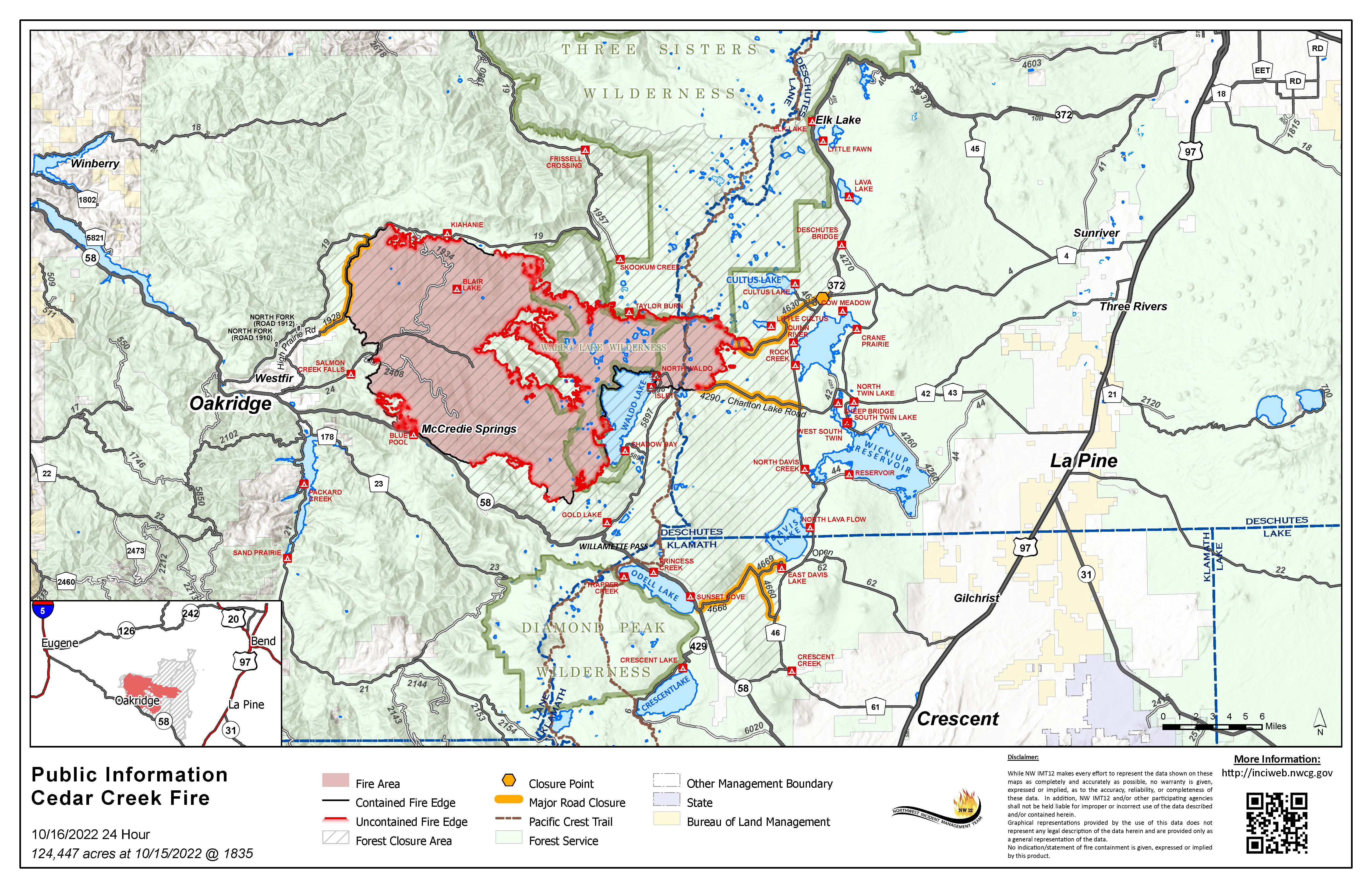
October 16, 2022 | Size: 124,447 acres | Origin: 15 miles E of Oakridge, OR | Containment: 45% | Cause: Lightning | Total personnel: 663 | Resources: 19 engines;13 crews; 7 helicopters;8 heavy equipment | Start Date: August 1, 2022
A community meeting will be held today, Sunday, October 16 at 4pm at the Oakridge High School Auditorium. You can also live stream the meeting on: Facebook.com/cedarcreekfire2022.
Weather: Critical fire weather continues. The upper-level flow will become a bit more southerly on Sunday as a ridge of high pressure moves east. This will result in slightly cooler temperatures and slightly higher relative humidity. Temperatures will still be above normal with highs 70-80 degrees and relative humidity 20-25 percent. Winds will remain out of the southeast 10-15 mph.
Operations: Red Flag weather conditions on the fire contributed to increased activity within the fire perimeter yesterday. Although there is a significant amount of smoke in the air, the fire remains within containment lines and crews are engaged in holding and securing any areas of intense heat. Air resources were engaged in operations whenever it was safe to fly, providing support to firefighters on the ground.
Repair projects across the fire area are ongoing. Firefighters are focusing efforts to hold and secure control lines in areas where the fire had previously challenged containment along the southern edge. Crews will continue to monitor and patrol in areas that experienced an increase in fire behavior during Red Flag weather yesterday. Hand crews and dozers are completing line construction along the southern edge of the fire. Assessment and repair continue around road systems along the northern edge of the fire. The west side of the fire perimeter will also see ongoing assessment of the road system and more chipping operations. Chipping operations near Cultus Lake have been completed. Road grading is underway on Forest Service Road 4868. Suppression repairs on the Big Swamp and Potter Fires should be completed by the end of shift today.
Closures: There are closures in effect on the Deschutes National Forest and Willamette National Forest. These closures will remain in place until areas impacted by the fire are surveyed for safety risks and fire crews are able to mitigate these hazards. Please respect Forest closures for firefighter and public safety. Please visit Willamette National Forest and Deschutes National Forest for the most recent closure orders and maps. Pacific Crest Trail hikers should visit pcta.org for current information. There is a Temporary Flight Restriction over the Cedar Creek Fire area. Wildfires are a No Drone Zone - if you fly, we can’t.
Smoke: Air quality conditions due to smoke are expected to be Good to Hazardous within the forecast area. Smoke impacts will be heavily dependent on fire activity. For current conditions, see Fire.airnow.gov, oakridgeair.org, and LRAPA - Today's Current Air Quality. Smoke Forecast Outlooks are available at https://outlooks.wildlandfiresmoke.net/outlook.
Evacuations: A map of the evacuation area is available at www.LaneCountyOR.gov/CedarCreek. Sign-up for emergency mobile alerts by going to oralert.gov. Please check with Lane County Sheriff’s Office at 541-682-4150 and Deschutes County Sheriff’s Office at 541-693-6911 for updates and changes.
Online: https://inciweb.nwcg.gov/incident/8307/ | www.facebook.com/CedarCreekFire2022/ www.tinyurl.com/cedarcreekfireyoutube| Fire Information Line: 541-201-2335, 8:00 AM – 8:00 PM | For Media Inquiries: 541-327-9925 | Email: 2022.cedarcreek@firenet.gov
Actualizacion Diaria Incendio Cedar Creek 15 de octubre 2022
Related Incident: Cedar Creek Fire
Publication Type: News
15 de octubre, 2022
Información actualizada
Resumen del Incendio Cedar Creek
Extensión: 123,861 acres
Origen: 15 millas E de Oakridge, OR
Recursos: 20 camiones; 13 Grupos; 7 helicópteros; 7 Maquinaria pesada
Contenido: 40%
Causa: Relámpagos
Personal: 669
Inicio: 1ro agosto, 2022
Se llevará a cabo una reunión para la comunidad el domingo, 16 de octubre a las 4pm, en el Auditorio de la escuela secundaria de Oakridge.
Operaciones realizadas: Anticipando un peligro critico en el incendio, los bomberos continuaran monitoreando y patrullando el área del incendio cercana de las líneas de contención, enfocando sus esfuerzos en las áreas de las líneas que anteriormente fueron impugnadas por las llamas. En el extremo sur del incendio, se continuará manteniendo y asegurando las áreas en donde las llamas saltaron la línea en la semana pasada. Se continua con la evaluación y reparación en la carretera forestal 1944 a lo largo del eje noreste del incendio. No se detienen las operaciones de astillado con el fin de remover los escombros y reparar los caminos sobre el perímetro oeste del incendio. Cerca de Cultus Lake y sobre la carretera forestal 4868, también se están dando operaciones de astillado y nivelación de la carretera. Las reparaciones de Supresión en los incendios Big Swamp y Potter posiblemente serán completadas al final del turno de trabajo de mañana.
Cierres de camino: Se encuentran en efecto órdenes de cierre de caminos y restricciones de incendio para los Bosques Nacionales de Deschutes y Willamette. Estas órdenes permanecerán en pie hasta que se haya realizado un estudio del peligro en las zonas que han sido fuertemente impactadas por el incendio y los bomberos hayan eliminado estos peligros. Por favor respete las ordenes de cierre de caminos para su seguridad y la de los bomberos. Para información actual y mapas, visite: Willamette National Forest y Deschutes National Forest. Se recomienda para los excursionistas en el sendero de Pacific Crest Trail, que visiten pcta.org para mantenerse informados del avance en el incendio. Se emitió una orden temporal de vuelos sobre la zona del Incendio Cedar Creek la cual se conoce como Temporary Flight Restriction. Incendios Forestales No son áreas para el uso de Drones: “Si Usted vuela, nosotros no podemos volar”
Condiciones del Humo: Debido a la presencia del humo, se esperan condiciones de la calidad del aire entre el rango de Buenas a Insalubres en el pronóstico para esta área. Las condiciones en el área de Oakridge continuaran siendo insalubres. El grado del impacto del humo depende especialmente en la actividad del incendio. Para información actual, lea Fire.airnow.gov, oakridgeair.org, y LRAPA - Today's Current Air Quality. Pronósticos del humo están disponibles en https://outlooks.wildlandfiresmoke.net/outlook
Evacuaciones: Un mapa actualizado acerca de las evacuaciones en la localidad está disponible en www.LaneCountyOR.gov/CedarCreek. Para recibir alertas móviles de emergencias, por favor regístrese en oralert.gov. Por favor, si necesita información actualizada en los cambios dados en el incendio visite, Lane County Sheriff’s Office, 541-682-4150 y Deschutes County Sheriff’s Office, 541-693-6911
Online: https://inciweb.nwcg.gov/incident/8307/ | www.facebook.com/CedarCreekFire2022/ www.tinyurl.com/cedarcreekfireyoutube
| Línea informativa: 541-201-2335, 8:00 AM – 8:00 PM | Para consultas con Medios comunicativos: 541-327-9925 | Email: 2022.cedarcreek@firenet.gov
Cedar Creek Fire Update October 15 2022
Related Incident: Cedar Creek Fire
Publication Type: News
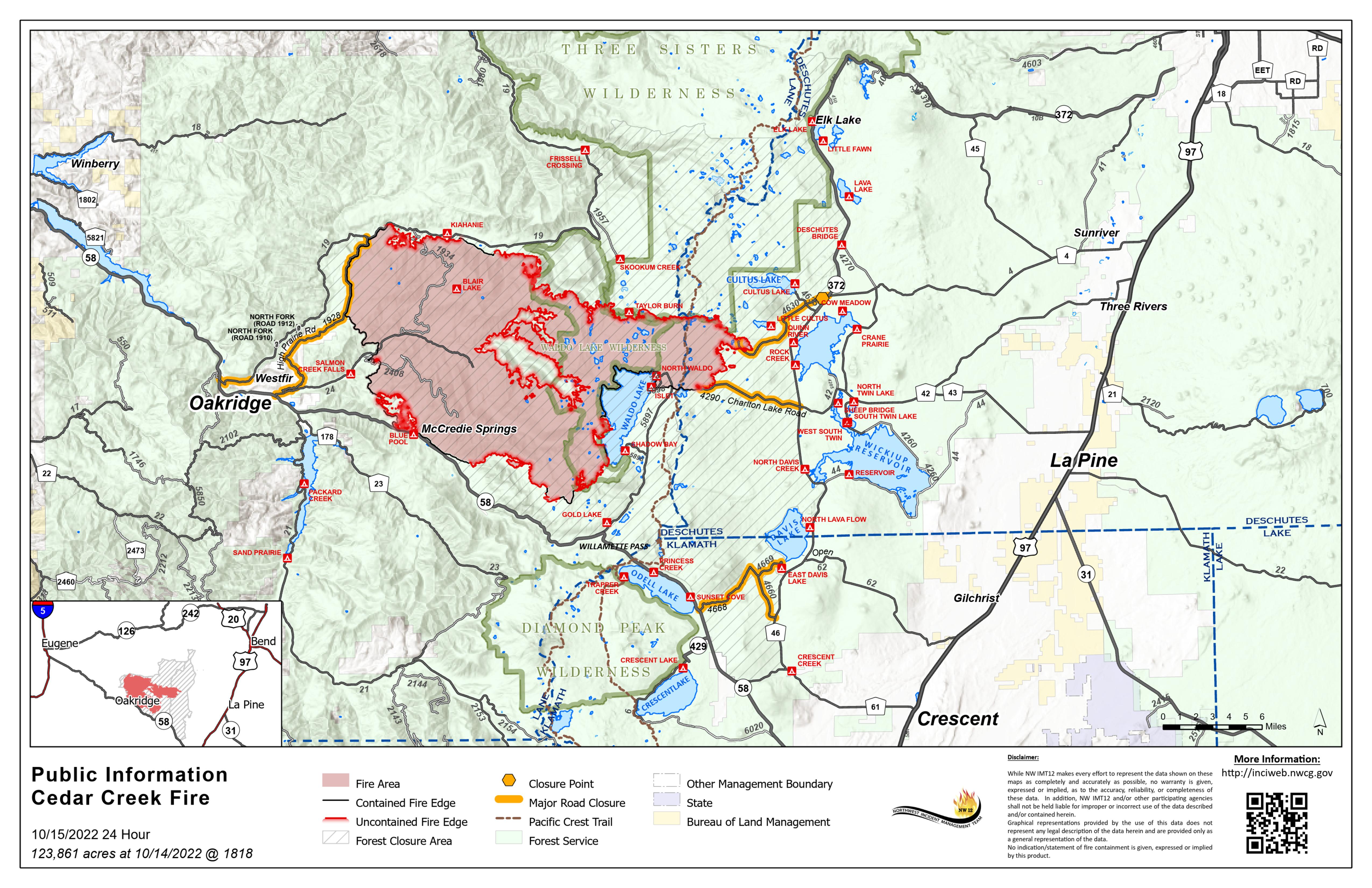
October 15, 2022 | Size: 123,861 acres | Origin: 15 miles E of Oakridge, OR | Containment: 40% | Cause: Lightning | Total personnel: 669 | Resources: 20 engines;13 crews; 7 helicopters; 7 heavy equipment | Start Date: August 1, 2022
A community meeting will be held on Sunday, October 16 at 4pm at the Oakridge High School Auditorium.
Weather: A red flag warning is in effect from 2am Saturday, October 15th until 6am Sunday, October 16th. The red flag warning combined with dry and receptive fuels present firefighters with critical fire danger. The morning inversion will still be quite strong. Temperatures are expected to be a few degrees cooler, but still 70-80 degrees. Minimum relative humidity will be 15-20 percent. Winds are expected to remain southeast throughout the day with gusts on the ridges 15-30 mph both day and night.
Operations: In anticipation of critical fire danger, firefighters will continue to monitor and patrol the fire area near containment lines, focusing efforts in areas that have previously challenged containment lines. Resources will be engaged on the southern tip of the fire to continue holding and securing the areas where fire crossed the line last week. Assessment and repair continue on Forest Service Road 1944 along the northern edge of the fire. Chipping operations to remove debris and road repairs are ongoing on the western fire perimeter. Chipping operations and road grading will also be underway near Cultus Lake and on Forest Service Road 4868.
Suppression repairs on the Big Swamp and Potter Fires should be completed by the end of shift tomorrow.
Closures: There are closures in effect on the Deschutes National Forest and Willamette National Forest. These closures will remain in place until areas impacted by the fire are surveyed for safety risks and fire crews are able to mitigate these hazards. Please respect Forest closures for firefighter and public safety. Please visit Willamette National Forest and Deschutes National Forest for the most recent closure orders and maps. Pacific Crest Trail hikers should visit pcta.org for current information. There is a Temporary Flight Restriction over the Cedar Creek Fire area. Wildfires are a No Drone Zone - if you fly, we can’t.
Smoke: Air quality conditions due to smoke are expected to be Good to Hazardous within the forecast area. Smoke impacts will be heavily dependent on fire activity. For current conditions, see Fire.airnow.gov, oakridgeair.org, and LRAPA - Today's Current Air Quality. Smoke Forecast Outlooks are available at https://outlooks.wildlandfiresmoke.net/outlook.
Evacuations: A map of the evacuation area is available at www.LaneCountyOR.gov/CedarCreek. Sign-up for emergency mobile alerts by going to oralert.gov. Please check with Lane County Sheriff’s Office at 541-682-4150 and Deschutes County Sheriff’s Office at 541-693-6911 for updates and changes.
Online: https://inciweb.nwcg.gov/incident/8307/ | www.facebook.com/CedarCreekFire2022/ www.tinyurl.com/cedarcreekfireyoutube| Fire Information Line: 541-201-2335, 8:00 AM – 8:00 PM | For Media Inquiries: 541-327-9925 | Email: 2022.cedarcreek@firenet.gov
Cedar Creek Fire Community Meeting on Sunday October 16
Related Incident: Cedar Creek Fire
Publication Type: Announcement
A community meeting will be held on Sunday, October 16th at 4 p.m.
You can attend in person at the Oakridge High School Auditorium or watch live on Facebook.
https://www.facebook.com/CedarCreekFire2022
If you are unable to attend in person or watch during the live stream, the recording will be available to view afterwards on the Cedar Creek Fire Facebook page.
Actualizacion Diaria Incendio Cedar Creek 14 de octubre 2022
Related Incident: Cedar Creek Fire
Publication Type: News
Incendio Cedar Creek
14 de octubre, 2022
Información actualizada
Resumen del Incendio Cedar Creek
Extensión: 123,498 acres
Origen: 15 millas E de Oakridge, OR
Recursos: 21 camiones; 14 Grupos;7 helicópteros;9 Maquinaria pesada
Contenido: 40%
Causa: Relámpagos
Personal: 673
Inicio: 1ro agosto, 2022
Condiciones climáticas: La alta presión atmosférica permanece en pie en el área. Tendencias secas y calurosas con temperaturas entre los 70 y 80 grados, que significa 10 a 20 grados superiores al promedio de la temporada. Mientras se siga presentando una inversión fuerte del clima, por las mañanas, se continuará experimentando la presencia del humo en el interior de los valles y se levantara en horas de la tarde. Vientos ligeros y variables. En horas de la mañana, los vientos se moverán hacia afuera de la zona sureste y por la tarde, estarán saliendo del área noroeste y noreste.
Condiciones del Humo: Debido a la presencia del humo, se esperan condiciones de la calidad del aire entre el rango de Buenas a Insalubres en el pronóstico para esta área. Las condiciones en el área de Oakridge continuaran siendo insalubres. En el área de Eugene, se experimentará una calidad del aire entre Moderado a Insalubre para grupos sensitivos, con un decrecimiento de humo por la tarde e incrementándose durante la noche. Esta mañana, Crescent Lake presentara condiciones buenas en la calidad del aire, pero incrementándose las condiciones del humo por la tarde y disipando durante horas del anochecer. Se pronostica la presencia continua de neblina y humo en la región sureste de Oregon. El impacto del humo depende especialmente en la actividad del incendio. Para información actual, lea Fire.airnow.gov, oakridgeair.org, y LRAPA - Today's Current Air Quality. Pronósticos del humo están disponibles en https://outlooks.wildlandfiresmoke.net/outlook.
Evacuaciones: Un mapa actualizado acerca de las evacuaciones en la localidad está disponible en www.LaneCountyOR.gov/CedarCreek. Para recibir alertas móviles de emergencias, por favor regístrese en oralert.gov. Por favor, si necesita información actualizada en los cambios dados en el incendio visite, Lane County Sheriff’s Office, 541-682-4150 y Deschutes County Sheriff’s Office, 541-693-6911
Online: https://inciweb.nwcg.gov/incident/8307/ | www.facebook.com/CedarCreekFire2022/ www.tinyurl.com/cedarcreekfireyoutube
| Línea informativa: 541-201-2335, 8:00 AM – 8:00 PM | Para consultas con Medios comunicativos: 541-327-9925 | Email: 2022.cedarcreek@firenet.gov
Cedar Creek Fire Update October 14 2022
Related Incident: Cedar Creek Fire
Publication Type: News
October 14, 2022 | Size: 123,498 acres | Contained: 40% | Start Date: August 1,2022 | Origin: 15 miles east of Oakridge, OR
Cause: Lightning | Total personnel: 673 | Resources: 21 engines; 14 crews; 9 heavy equipment; 7 helicopters
Weather: High pressure remains in place over the fire area today, continuing a warming and drying trend with temperatures in the mid 70-80s, 10-20 degrees above seasonal averages. As strong inversion persists smoke will continue in the valleys in the morning and lift smoke into the fire area in the afternoon. Winds will be light and variable. In the morning winds will be out of the southeast and in the afternoon out of the northwest and northeast..
Operations: Elevated fire weather conditions persist as firefighters patrol the fire area searching for and extinguishing remaining heat sources near containment lines. Yesterday, fire activity increased as numerous interior pockets of unburned fuel responded to record temperatures for the season and gusty winds. This uptick in activity in the interior of the fire produced a visible smoke column and contributed to smoky conditions in communities around the fire area.
Fire crews continue to secure the “slopover” areas near Lucas Lake and are preparing the 500 Road as a containment line. Fire hose around the perimeter of these “slopover” fires is being utilized to add depth to these containment lines.
On the northern portion of the fire, fire crews are repairing Forest Service Roads 305, 310 and 750 and are assessing necessary repairs to Forest Service Road 1944. On the western fire perimeter, firefighters are continuing to chip woody debris left over from fire suppression and are completing road repairs. On the eastern fire edge, debris chipping operations continue near Cultus Lake and firefighters will be grading Forest Service Road 4668 to return it to a pre-fire condition.
Suppression repairs on the Big Swamp and Potter Fires are beginning to wind down as firefighters are completing water bars and hauling out materials.
Closures: There are closures in effect on the Deschutes National Forest and Willamette National Forest. These closures will remain in place until areas impacted by the fire are surveyed for safety risks and fire crews are able to mitigate these hazards. Please respect Forest closures for firefighter and public safety. Please visit Willamette National Forest and Deschutes National Forest for the most recent closure orders and maps. Pacific Crest Trail hikers should visit pcta.org for current information. There is a Temporary Flight Restriction over the Cedar Creek Fire area. Wildfires are a No Drone Zone - if you fly, we can’t.
Smoke: Air quality conditions due to smoke are expected to be Good to Hazardous within the forecast area. Continued Unhealthy to Hazardous conditions persist in Oakridge. Eugene will see Moderate air quality this morning with decreasing smoke this afternoon. Crescent Lake will have Good to Moderate air quality today. Continued regional haze and smoke is predicted for southern Oregon. Smoke impacts will be heavily dependent on fire activity.
For current conditions, see Fire.airnow.gov, oakridgeair.org, and LRAPA - Today's Current Air Quality. Smoke Forecast Outlooks are available at https://outlooks.wildlandfiresmoke.net/outlook.
Evacuations: A map of the evacuation area is available at www.LaneCountyOR.gov/CedarCreek. Sign-up for emergency mobile alerts by going to oralert.gov. Please check with Lane County Sheriff’s Office at 541-682-4150 and Deschutes County Sheriff’s Office at 541-693-6911 for updates and changes.
Online: https://inciweb.nwcg.gov/incident/8307/ | www.facebook.com/CedarCreekFire2022/ www.tinyurl.com/cedarcreekfireyoutube
| Fire Information Line: 541-201-2335, 8:00 AM – 8:00 PM | For Media Inquiries: 541-327-9925 | Email: 2022.cedarcreek@firenet.gov
Actualizacion Diaria Incendio Cedar Creek 13 de octubre 2022
Related Incident: Cedar Creek Fire
Publication Type: News
Incendio Cedar Creek
13 de octubre, 2022
Información actualizada
Resumen
Extensión: 122,975 acres
Origen: 15 millas E de Oakridge, OR
Recursos: 21 camiones; 13 Grupos;7 helicópteros;9 Maquinaria pesada
Contenido: 40%
Causa: Relámpagos
Personal: 677
Inicio: 1ro agosto, 2022
Condiciones climáticas: Para el resto de esta semana, permanecerá una tendencia seca y calurosa, con temperaturas por lo menos de 5 – 10 grados más alto del promedio estacional del clima. El día de hoy, este tipo de clima, combinado con un incremento en el viento, conducirá a un estado crítico en las condiciones climáticas en el interior del incendio. El día de hoy, se experimentarán temperaturas entre los 75 y 85 grados en toda el área del incendio.
Operaciones realizadas: El día de ayer, los bomberos finalizaron la instalación de mangueras alrededor de las zonas en donde se dio el salto del fuego localizado sobre el perímetro sureste del fuego y cercano a Lucas Lake. Los bomberos se encuentran supliendo de agua alrededor del perímetro de dichas áreas. Asimismo, están asegurando y profundizándose en el interior de estas líneas de contención. Otro grupo de bomberos esta trabajando en la preparación de la carretera 500 como una línea secundaria de fuego en la misma área. Nuevamente, los bomberos estarán vigilantes tomando en cuenta las condiciones climáticas criticas en el incendio cuando se dedican al patrullaje alrededor del incendio, identificando espacios remanentes de emanación de calor cerca de las líneas de contención. Sobre la porción noreste del incendio, los bomberos están reparando las carreteras 305, 310 y 750 y están evaluando al mismo tiempo, las reparaciones necesarias para reabrir la carretera 1944. En el perímetro oeste del fuego, los bomberos continúan con el astillado de escombros de madera que se dieron como resultado de las operaciones de supresión del incendio y además están completando reparaciones de camino. En el lado Oeste del eje del incendio, también se continúa astillando escombros cerca de Cultus Lake y los bomberos estarán nivelando la carretera 4668 con el fin de regresarla a su estado original. Varias zonas internas de calor formadas con material de combustión, continuara quemándose con el incremento de las temperaturas y la baja humedad. Esto seguirá produciendo condiciones de humo en el área afectada. Operaciones de reparación de supresión en los incendios Big Swamp y Potter están completándose con los trabajos de construcción de carreteras, nivelación de caminos y quitando los escombros de madera después del incendio.
Cierres de camino: Se encuentran en efecto ordenes de cierre de caminos y restricciones de incendio para los Bosques Nacionales de Deschutes y Willamette. Estas órdenes permanecerán en pie hasta que se haya realizado un estudio del peligro en las zonas que han sido fuertemente impactadas por el incendio y los bomberos hayan eliminado estos peligros. Por favor respete las ordenes de cierre de caminos. Para información actual y mapas, visite: Willamette National Forest y Deschutes National Forest. Se recomienda para los excursionistas en el sendero de Pacific Crest Trail, que visiten pcta.org para mantenerse informados del avance en el incendio. Se emitió una orden temporal de vuelos sobre la zona del Incendio Cedar Creek la cual se conoce como Temporary Flight Restriction. Incendios Forestales No son áreas para el uso de Drones – “Si Usted vuela, nosotros no podemos volar”
Condiciones del Humo: Se esperan condiciones de la calidad del aire entre el rango de Buenas a Insalubres en el pronóstico para esta área. Las condiciones en el área de Oakridge continuaran siendo insalubres. En el área de Eugene, se experimentará una calidad del aire entre Moderado a Insalubre para grupos sensitivos, con un decrecimiento de humo por la tarde e incrementándose en las horas de la noche de hoy. Esta mañana, Crescent Lake presentara condiciones buenas en la calidad del aire pero incrementándose las condiciones del humo por la tarde. Se observará un decrecimiento de este, al anochecer. Para información actual, lea Fire.airnow.gov, oakridgeair.org, y LRAPA - Today's Current Air Quality. Pronósticos del humo están disponibles en https://outlooks.wildlandfiresmoke.net/outlook
Evacuaciones: Un mapa actualizado acerca de las evacuaciones en la localidad está disponible en www.LaneCountyOR.gov/CedarCreek. Para recibir alertas móviles de emergencias, por favor regístrese en oralert.gov. Por favor, si necesita información actualizada en los cambios dados en el incendio visite, Lane County Sheriff’s Office, 541-682-4150 y Deschutes County Sheriff’s Office, 541-693-6911
Online: https://inciweb.nwcg.gov/incident/8307/ | www.facebook.com/CedarCreekFire2022/ www.tinyurl.com/cedarcreekfireyoutube
| Línea informativa: 541-201-2335, 8:00 AM – 8:00 PM | Para consultas con Medios comunicativos: 541-327-9925 | Email: 2022.cedarcreek@firenet.gov
Cedar Creek Fire Update October 13 2022
Related Incident: Cedar Creek Fire
Publication Type: News
Cedar Creek Fire
October 13, 2022 | Size: 122,794 acres | Origin: 15 miles E of Oakridge, OR | Containment: 40% | Resources: 21 engines; 13 crews; 7 helicopters;9 heavy equipmentCause: Lightning | Total personnel: 677 | Start Date: August 1, 2022
Weather: High pressure remains in place over the fire area the rest of this week, continuing a warming and drying trend with temperatures at least 5-10 degrees above seasonal averages. These conditions combined with increased winds will lead to critical fire weather conditions today. Today will be a warmer day, with temperatures ranging from 75-85 degrees across the fire area.
Operations: Firefighters completed a network of fire hoses around the fire lines on both pockets of “slopover” fire on the southern fire perimeter near Lucas Lake yesterday. Fire crews are now delivering water around the perimeter of these slopover fires and are securing and adding depth to these containment lines. Fire crews are also working to prepare the 500 Road as a secondary line in this area.
Firefighters will again be watchful with today’s second day of critical fire weather conditions as they patrol around the fire, searching for and extinguishing remaining heat sources near containment lines. On the northern portion of the fire, fire crews are repairing the 305, 310 and 750 Roads and are assessing necessary repairs to reopen the 1944 Road. On the western fire perimeter, firefighters are continuing to chip woody debris left over from fire suppression and are completing road repairs. On the eastern fire edge, debris chipping operations continue near Cultus Lake and firefighters will be grading the 4668 Road to return it to a pre-fire condition. Numerous interior pockets of unburned fuel continue to burn with increased temperatures and lower humidity, leading to ongoing smoky conditions.
Suppression repairs on the Big Swamp and Potter Fires are beginning to wind down as firefighters are completing remaining road repairs, grading, and woody debris removal.
Closures: There are closures in effect on the Deschutes National Forest and Willamette National Forest. These closures will remain in place until areas impacted by the fire are surveyed for safety risks and fire crews are able to mitigate these hazards. Please respect Forest closures for firefighter and public safety. Please visit Willamette National Forest and Deschutes National Forest for the most recent closure orders and maps. Pacific Crest Trail hikers should visit pcta.org for current information. There is a Temporary Flight Restriction over the Cedar Creek Fire area. Wildfires are a No Drone Zone - if you fly, we can’t.
Smoke: Air quality conditions due to smoke are expected to be Good to Hazardous within the forecast area. Continued Unhealthy to Hazardous conditions persist in Oakridge. Eugene will see Moderate to Unhealthy for Sensitive Groups air quality this morning with decreasing smoke this afternoon but increasing overnight. Crescent Lake will have Good air quality this morning with increasing smoky conditions this afternoon and decreasing overnight. For current conditions, see Fire.airnow.gov, oakridgeair.org, and LRAPA - Today's Current Air Quality. Smoke Forecast Outlooks are available at https://outlooks.wildlandfiresmoke.net/outlook.
Evacuations: A map of the evacuation area is available at www.LaneCountyOR.gov/CedarCreek. Sign-up for emergency mobile alerts by going to oralert.gov. Please check with Lane County Sheriff’s Office at 541-682-4150 and Deschutes County Sheriff’s Office at 541-693-6911 for updates and changes.
Online: https://inciweb.nwcg.gov/incident/8307/ | www.facebook.com/CedarCreekFire2022/ www.tinyurl.com/cedarcreekfireyoutube Fire Information Line: 541-201-2335, 8:00 AM – 8:00 PM | For Media Inquiries: 541-327-9925 | Email: 2022.cedarcreek@firenet.gov