
Possum Kingdom Lake Access
Related Incident: Storage Fire
Publication Type: Closures
Palo Pinto County Emergency Management Officials and the Brazos River Authority have coordinated with the Texas A&M Forest Service Incident Command to inform the public that Possum Kingdom Lake is open to public access. However, BE AWARE that aerial assets continue firefighting efforts to extinguish the Storage Fire. These firefighting efforts include ground crews and the aerial water extraction near the Sportsman's World and Gaines Bend areas.
For the latest updates on wildfire status, visit the Texas A&M Forest Service website here: https://inciweb.nwcg.gov/incident-publication/txtxs-storage-fire/
Public Safety Closure goes into effect due to Pass Fire
Related Incident:
Publication Type: Closures
MIMBRES, NM, June 30, 2023 – A road and trail closure goes into effect at 4:00 p.m. today, impacting several trails within and adjacent to the Pass Fire. The closure is necessary to protect firefighter and public safety in an area of active fire operations and heavy firefighter activity.
“As the fire has marched southward, it has drawn nearer to popular trails and wilderness destinations, increasing the threat to public safety,” said Wilderness District Ranger Henry Provencio. “The closure of a limited number of trails allows firefighters to focus on their work, relieving their concern about members of the public who may be within the fire perimeter, in case fire behavior were to become more threatening.”
The trail closure includes:
- Iron Trail # 771 from the East Fork of the Gila River, west approximately 4 miles to the intersection with Trail # 27.
- White Rocks Trail # 27 from the intersection of NFST # 804 in a predominately northwest direction approximately 4 miles to the intersection with NFST # 26.
- Green Fly Trail # 26 from its beginning at the end of National Forest System Road (NFSR) 704, in a predominately northwest direction for approximately 10.5 miles, to the intersection of Trail # 23.
- CCC Trail # 772 from the end of NFSR 4208P, northwest for approximately 3.5 miles to the Black Mountain Lookout tower.
- Middle Fork Trail # 157 from Jordan Hot Springs, west for approximately 5 miles to its intersection with Trail # 53.
- NFSR # 704 in its entirety.
- NFSR # 4208P in its entirety. See attached map, marked Exhibit A.
Closure Order No. 03.06.02.23.006 goes into effect at 4:00 p.m. Friday, June 30, 2023 and will remain in effect through 8:00 a.m. August 15, 2023, unless rescinded sooner. It will be enforced through firefighter presence and patrols by law enforcement, and other staff. The order and the associated closure map are available online at https://www.fs.usda.gov/alerts/gila/alerts-notices/?aid=81215. For more information contact Maribeth Pecotte at 575-388-8211 or Maribeth.Pecotte@usda.gov.
###
USDA Forest Service is an equal opportunity provider, employer, and lender.
Want to help the firefighters on the Spring Creek Fire
Related Incident: Spring Creek Fire
Publication Type: News
We’re doing well on supplies, food, and making progress on containing the fire. However, we still need your help this coming holiday weekend! A new fire start could pull crews and equipment away from the Spring Creek Fire and slow progress here, so we’re asking you to be safe and prevent any additional wildfires. Some easy things to do include:
· Make sure your campfires are placed in areas that are clear from dry grasses and other fuels.
· Pour plenty of water on your campfire and stir, ensuring your campfire is cold and out before you leave your site.
· Properly attach your trailer chains, so they aren’t dragging as you head to the mountains.
· Remember fireworks are illegal on all federally-managed lands.
Thanks for your support and have a great weekend.
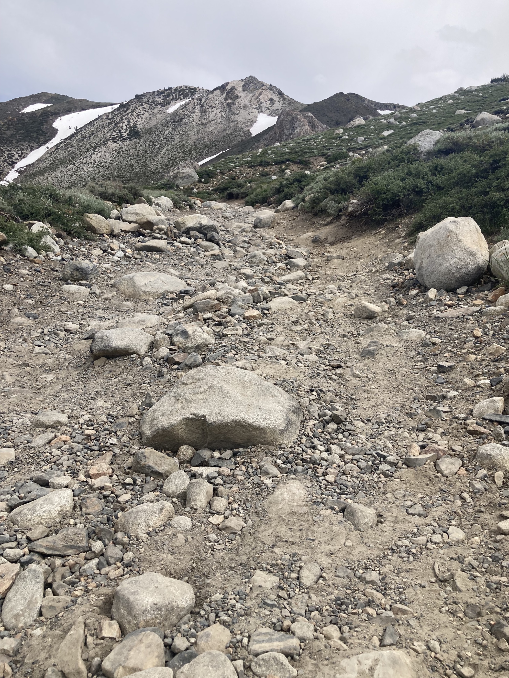
Alert of a Very Large Washout on Deer Springs Road
Related Incident: INYO NATIONAL FOREST--FLOOD RESPONSE
Publication Type: Announcement
ALERT of a very large washout (location coordinates: 37.66388, -118.60385) on Deer Springs Road (FS 3S01) just west of junction with Benton Crossing Road.
SEE PHOTO BELOW UNDER RELATED INFORMATION OR ABOVE UNDER PHOTOS TAB
_0.png?VersionId=.Lg8qZAQhRLa5uiSftUsxL3VwcrDVKiH)
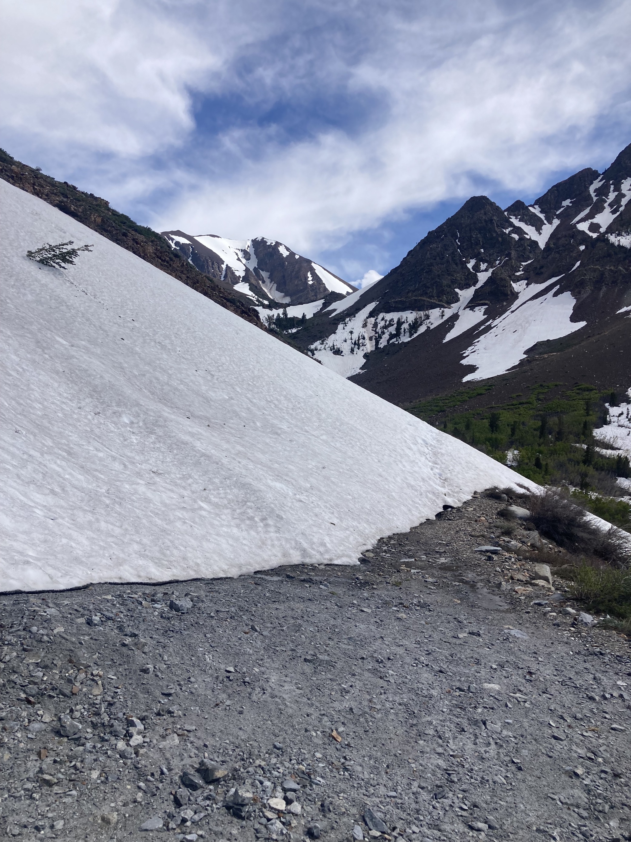
Large Impassable Snowdrift Along Very Rough Dirt Road to Laurel Lakes
Related Incident: INYO NATIONAL FOREST--FLOOD RESPONSE
Publication Type: Announcement
Alert of a large impassable snowdrift about 3 miles up the very rough dirt road with much more snow in the final mile that is blocking vehicle access to Laurel Lakes well into July.
SEE 2 PHOTOS BELOW UNDER RELATED INFORMATION OR ABOVE UNDER PHOTOS TAB
Settings - change map background and toggle additional layers
Filter - control incident types displayed on map.
Zoom to your location
Reset map zoom and position
Could not determine your location.
Show Legend
 Wildfire
 Prescribed Fire
 Burned Area
Response
Burned Area
Response Other
Other
Titan Fire
Unit Information
Incident Contacts
Chris Mountain Fire Closure
Related Incident: Chris Mountain Fire
Publication Type: Closures
San Juan National Forest
15 Burnett Court
Durango, CO 81301
(970) 247-4874 Fax: (970) 375-2319
Subject: Forest Order Closure - Chris Mountain Fire Area, Road, and Trail Closure - Pagosa Ranger District - Order Number 02-13-06-23-04
Attached is Forest Order Number 02-13-06-23-04 for:
The Described Area is in Archuleta County, Colorado, and contains the NFS lands within an area bordered by and including the following Described Roads and Trails: Beginning at the intersection of the Piedra Stock Driveway Trail (NFS Trail 583) and the Devil Mountain Trail (NFS Trail 600) extending south following the Piedra Stock Driveway Trail (NFS Trail 583) to the Monument Park East Road (NFS Road 630); from this point extending east along the Monument Park East Road (NFS Road 630) to the intersection with the Turkey Springs Road (NFS Road 629); from this point extending south along the Turkey Springs Road (NFS Road 629) to the intersection with Snow Ranch Road (NFS Road 628); from this point extending west along Snow Ranch Road (NFS Road 628) to the intersection with the Snow Springs Trail (NFS Trail 605); from this point extending north along the Snow Springs Trail (NFS Trail 605) to the intersection with the Devil Mountain Trail (NFS Trail 600); from this point extending east along the Devil Mountain Trail (NFS Trail 600) to the junction with the Piedra Stock Driveway Trail (NFS Trail 583).
EXEMPTIONS
Pursuant to 36 C.F.R. § 261.50(e), the following persons are exempt from this Order:
1. Persons with Forest Service Permit No. FS-7700-48 (Permit for Use of Roads, Trails, or Areas Restricted by Regulation or Order), specifically exempting them from this Order or a written determination by a Forest Service authorized officer that a permit is not required under 36 C.F.R. § 251.50(e)(1) or (2).
2. Any Federal, State, or Local Officer, or member of an organized rescue or firefighting force in the performance of an official duty.
Please post the attached Forest Order, map, and accompanying Public Notice in your Forest Orders notebooks and place a copy in your files. Also, post the Public Notice on your public bulletin boards, social media outlets and websites.
If you have any questions regarding this order, please contact Joshua Peck, Pagosa District Ranger at 970-264-1520 or joshua.p.peck@usda.gov. For questions regarding the posting of this order and the public notice, please contact Executive Assistant, Beth Fox at 970-385-1290 or elizabeth.fox@usda.gov.
Firing operations continue on Ridge and Three Lakes fires
Related Incident: Hull FireRidge FireThree Lakes Fire
Publication Type: News
Williams, Ariz., June 30, 2023 – With light winds and double-digit humidities this weekend, fire managers on the Ridge and Three Lakes fires will be able to continue tactical firing operations. This means crews apply fire to strategic locations within the planning areas as a safety measure in advance of the main fire. Doing so helps maintain the generally slower pace and lower intensity as the fire moves across the landscape. On the North Kaibab Ranger District, tactical firing operations along State Route 67 are creating a fire-treated boundary on the eastern edge of the Three Lakes Fire planning area. Crews on the Tusayan Ranger District are working on the eastern and northwestern edges and in the interior of the Ridge Fire planning area.
To reduce risks to ground crews, fire managers on the Ridge Fire are using an Uncrewed Aerial System (or drone) to conduct reconnaissance and ignitions in areas where entry by foot or vehicle is unsafe or impossible due to high temperatures and hazardous terrain. Under the direction of on-the-ground personnel, the drone will deploy “dragon eggs”, potassium permanganate-filled plastic balls injected with glycol prior to release. These spheres drop from the drone and ignite 10 seconds later after hitting the ground.
Ridge Fire: 3,131 acres with slow growth within the planning area - Seventy-nine personnel are assigned to this fire.
Three Lakes Fire: 2,481 acres with slow growth within the planning area – Ninety-eight personnel are assigned to this fire. Some short-term smoke impacts to State Route 67 are possible. Fire managers are working closely with Arizona Department of Transportation to use pilot cars if necessary. Motorists should be prepared to slow down or briefly stop.
Hull Fire: 1,491 with no growth within the planning area – Twenty-five personnel are currently assigned to this fire.
More details on each fire can be found on InciWeb.
Managing naturally caused wildfires across the landscape is a very effective tool in restoring the forest to a healthier condition, and these efforts align with the Forest Service's 10-year Wildfire Crisis Strategy, which aims to increase the use of fire on the landscape as well as other treatments to improve forest resiliency for generations to come.
Additional information can be found on the Kaibab NF website, Twitter, Facebook, Flickr, or by calling the Fire Information Hotline at 928-635-8311 or local ranger stations.
Actualizacin del Incendio Spring Creek 30 de Junio 2023
Related Incident: Spring Creek Fire
Publication Type: News
Actualización del Incendio Spring Creek
30 de Junio, 2023
Equipo de Gestión de Incidentes del Complejo del área de las Montañas Rocosas Dos
Jared Hohn, Comandante del Incidente
Fecha Reportada: 24 de Junio, 2023
Causa: Bajo Investigación
Tamaño: 2, 910 acres
Confinamiento: 21%
Personal Total: 441
Locación: Sur oeste de Parachute, CO.
Situación Actual: Los bomberos continúan con los esfuerzos de supresión del incendio de Spring Creek. Los equipos han completado la línea de mano indirecta en el lado norte del incendio. Esta línea “indirecta” es una táctica eficaz para eliminar la vegetación seca delante del fuego y retrasar el avance del fuego debido a la falta de material combustible. Hoy, una excavadora continuará mejorando la línea indirecta en el lado noreste del incendio y las cuadrillas han comenzado a mejorar la carretera Dry Creek al reducir la vegetación al costado del camino. Helicópteros lanzan cubos de agua para evitar que las áreas calientes del fuego progresen fuera de la huella de fuego actual, mientras que las cuadrillas de mano van directamente a lo largo de la línea de fuego del sur. Los bomberos continúan buscando calor alrededor del lado occidental del fuego y están logrando contención. El fuego tuvo un crecimiento mínimo durante la noche, mientras que el turno de noche continúa monitoreando las condiciones y el comportamiento del fuego.
La carretera Spring Creek y High Mesa están abiertas solo al tráfico local. Evite estas áreas si es posible y conduzca con precaución con el aumento de personal de bomberos en la carretera.
Información sobre el Clima y el Humo: Se espera una inversión esta mañana y se espera que se levante alrededor de las 10 a. m. Las temperaturas estarán entre medio-alto 70 grados. Se espera que la humedad adicional se mueva hacia la región que mantendrá la humedad relativa y traerá posibles tormentas eléctricas secas en todo el oeste de Colorado que pueden traer ráfagas de viento. Se esperan vientos de 5 a 10 mph desde el noroeste, pero seguirán siendo más ligeros que en días anteriores. Se espera que las temperaturas de esta noche caigan a los 50 grados y se espera que la humedad real alcance un máximo del 50%. Otra inversión se formará durante la noche. El incendio de Spring Creek está produciendo humo que puede afectar la calidad del aire. Para obtener información sobre la calidad del aire actual y problemas de salud relacionados, visite garfield-county.com/air-quality o fire.airnow.gov.
Cierres: Oficina de Administración de Tierras La Oficina de Campo del Valle del Río Colorado y el Bosque Nacional del Río Blanco del Servicio Forestal de EE. UU. tienen órdenes de cierre de tierras públicas vigentes para la seguridad del público y de los bomberos.
Visite la oficina de campo de BLM Colorado River Valley y el Servicio Forestal de EE. UU. – White River para conocer las órdenes de cierre.
Evacuaciones: En estos momentos no hay evacuaciones. Se les pide a los residentes a registrarse en el sistema de notificación de emergencia del condado de Garfield en: Autoridad de Comunicaciones de Emergencia del Condado de Garfield (garco911.com). Todas las órdenes de evacuación se realizarán a través de la oficina del Sheriff. Llame a la línea de mensajes grabados al 970-981-3401 para obtener información actualizada sobre evacuaciónes.
Restricciones Temporales de Vuelo: Existe una restricción de vuelo temporal (FDC 3/7086) para el espacio aéreo sobre el incendio de Spring Creek para reducir los impactos en los operadores de aviación de incendios. La respuesta de la aviación contra incendios se detiene o retrasa si una aeronave no autorizada ingresa a la área restringida. Las restricciones temporales de vuelo también se aplican a los sistemas de aeronaves no tripuladas (UAS) o drones. ¡Si tú vuelas, nosotros no podemos!
Línea Telefónica de Información Sobre el Incendio: (970)414-1772 Horario: 8am – 9pm
Facebook: SpringCreekFire2023 Correo Electrónico: 2023.springcreek@firenet.gov InciWeb: Spring Creek Fire Information
Pass Fire update for June 30 2023
Related Incident:
Publication Type: News
Acres: 57,670
Start Date: May 18, 2023
Location: 40 miles west of Winston, NM Cause: Lightning
Containment: 12%
Fuels: Timber, piñon/juniper and grass
Personnel: 140, 1 Type 1 Helicopter, 2 Type 3 Helicopters
Fire activity and growth were minimal yesterday, with low to moderate fire behavior observed. The most active area of fire perimeter was along southwest corner in the Log Canyon area above the Middle Fork Gila River. Today, crews plan to complete hand ignitions along the Iron Trail (771) and White Rocks Trail (27) to remove available fuels and establish containment along the southeastern fire perimeter, where fire has been active in the Burnt Corral Canyon area. With these hand ignitions, fire acreage can be expected to be greater tomorrow.
A “confine and contain” strategy allows fire to play its natural role in fire-adapted forest ecosystems, while protecting private land, infrastructure, and natural resource values at risk. Fire is a normal visitor to the Gila landscape and something with which we all have to cope. Ecosystems here are not only adapted to fire, but dependent on the frequent return of low to moderate intensity fire to maintain healthy forest, watershed, and fuels conditions.
The Wildland Fire Crisis Strategy calls for more fire on forest landscapes, at an increased pace and scale, in order to change the trajectory of ever larger and more frequent catastrophic wildfires. Despite inconvenience to visitors and unavoidable smoke impacts, the occurrence of this naturally ignited, low- to moderate-intensity fire today will help reduce the risk of a catastrophic, crown-dominated fire in this area for years into the future.
Increased smoke production can be expected with today’s firing operations. It settles into lower valleys during overnight heat inversions. Low elevation smokey conditions may persist during early morning hours, generally lifting with solar heating.
Weather: Sunny, with highs of 82 – 87 F and west winds of 5 - 12 mph. Conditions will be very dry with 5 – 10% minimum relative humidity. Fire danger is increasing under these hot, dry weather conditions. The need for fire restrictions on the Gila National Forest is reassessed daily. If they are allowed and weather permits, you must attend your campfire at all times, or extinguish it fully when it is not attended. Douse with plenty of water, stir it into the coals, and feel for heat. Extinguished means cold to the touch with your bare hand.
Aviation Restrictions: A Temporary Flight Restriction (TFR) is still in place over the Pass Fire. All non-fire aircraft are restricted. This includes civilian drones. Unauthorized aircraft in the area will ground firefighting aircraft, hindering firefighting efforts. If you fly, we can’t.
For More Information:
- Inciweb: https://inciweb.wildfire.gov/incident-information/nmgnf-pass-fire
- New Mexico Fire Information: https://nmfireinfo.com/
- Air Quality: https://www.airnow.gov