
Storage Fire Evening Update
Related Incident: Storage Fire
Publication Type: News
Storage Fire
June 29, 2023
5:45 p.m.
Size: 600+ acres
Containment: 30%
Start Date: June 28, 2023
Cause: Under Investigation, Human Caused
Evacuations: There are Mandatory Evacuations in place for the communities of Gaines Bend, Sportsman's World, and Hell's Gate. Residents should leave these areas as quickly and orderly as they can
Fire crews have been working all day to contain the Storage Fire in extreme heat and windy conditions. The fire spotted over the containment lines constructed last night this afternoon and has showcased active to extreme fire behavior as it continued burning. The wind has been aligning with the fire and causing large and rapid growth at times causing firefighters to take a more defensive approach to attacking this fire.
As the fire has been pushing to the north and west crews are now focusing on protecting structures in the communities that are currently under mandatory evacuations. There are airtankers coming into the area to conduct drops to slow the spread of the fire towards these homes. Members of the public should note that anything in the area such as drones, planes, or helicopters will cause all air operations to cease until those items have left the area, potentially hampering firefighting operations. Crews will be working through the night again to get a handle on this fire and to protect the homes and properties along Lake Possum Kingdom.
At this time there have been no reported injuries or property damages.
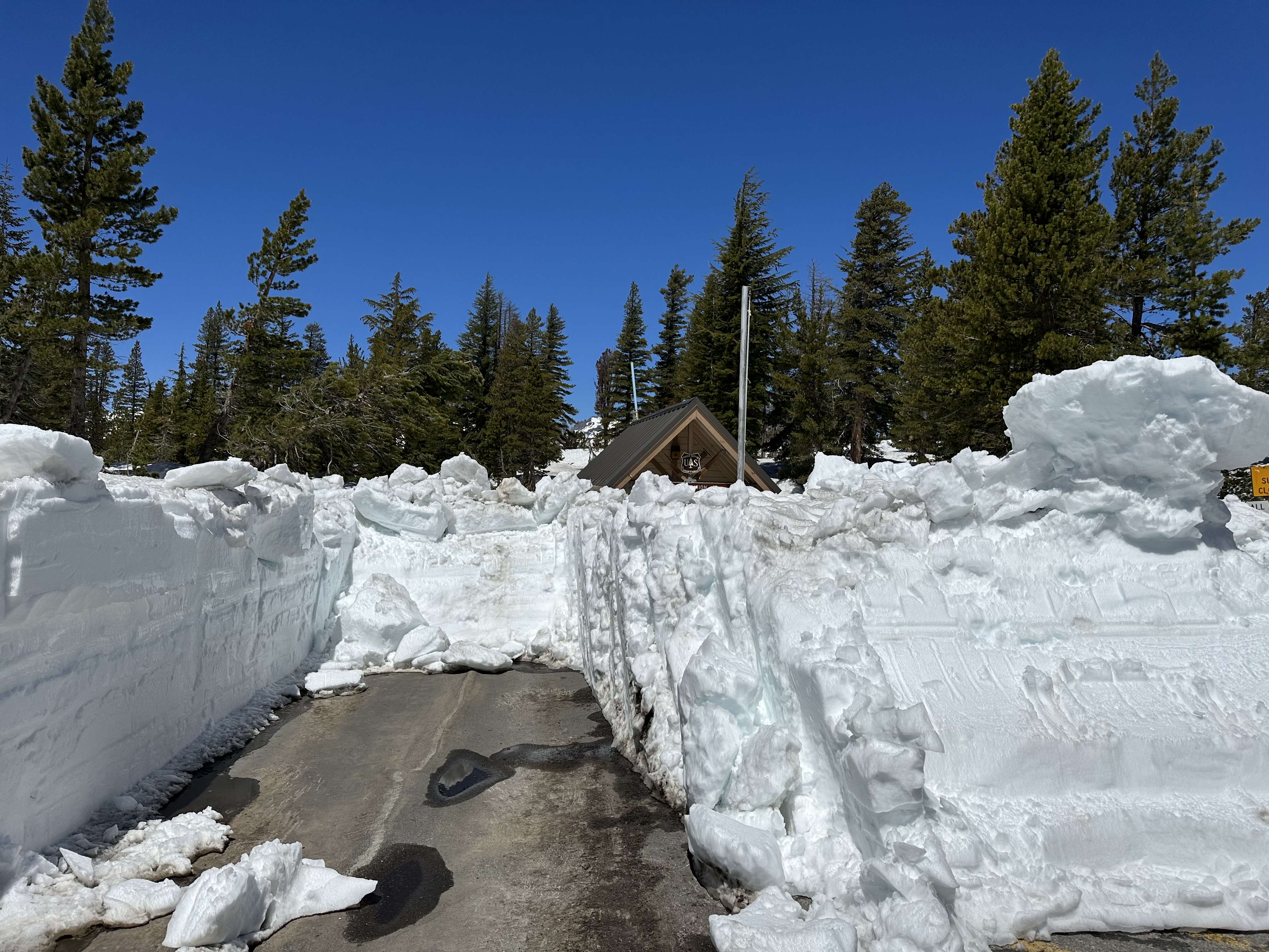
Many Feet of Snow Keeps Reds Meadow Road Closed at Minaret Summit as of June 29
Related Incident: INYO NATIONAL FOREST--FLOOD RESPONSE
Publication Type: Announcement
Many Feet of Snow Keeps Red's Meadow Road Closed at Minaret Summit as of June 29
June 20 photo shows many feet of snow across Red's Meadow Road at Entrance of Minaret Summit and why the road is still closed as of June 29, 2023.
SEE PHOTO BELOW UNDER RELATED INFORMATION OR ABOVE UNDER THE PHOTOS TAB
Mandatory Evacuations Storage Fire 6292023 500 PM
Related Incident: Storage Fire
Publication Type: Announcement
Storage Fire Evacuation Update:
Gaines Bend, Sportsman's World, and Hell's Gate communities are now under a Mandatory Evacuation. The Storage Fire is moving actively towards the Gaines Bend community and threatening 150 homes in those neighborhoods.
The Storage Fire is growing rapidly to the north and west and these communities should take the opportunity to evacuate ahead of this threat. When people evacuate an area ahead of time, fire personnel can focus their efforts on protecting homes and values in a neighborhood.
Residents should keep the 5 P's of evacuating in mind when leaving. These are People & Pets, Prescriptions, Important Papers, Personal and Priceless items. Take all of these with you along with what you may need for 48 hours away from your home.
Settings - change map background and toggle additional layers
Filter - control incident types displayed on map.
Zoom to your location
Reset map zoom and position
Could not determine your location.
Show Legend
 Wildfire
 Prescribed Fire
 Burned Area
Response
Burned Area
Response Other
Other
Broadway Fire
Unit Information
Incident Contacts
Settings - change map background and toggle additional layers
Filter - control incident types displayed on map.
Zoom to your location
Reset map zoom and position
Could not determine your location.
Show Legend
- Wildfire
- Prescribed Fire
- Burned Area
Response
- Other
Pika Fire
Unit Information
Incident Contacts
Voluntary Evacuations in Gaines Bend
Related Incident: Storage Fire
Publication Type: Announcement
All homes in the Gaines Bend community are currently under a voluntary evacuation orders. This community only has one access road in and out and is currently threatened by the Storage fire as it grows to the North. Residents are advised to leave the area to ensure that if the fire does reach the neighborhood, fire personnel can focus on protecting structures and properties in the area.
Actualizacin del Incendio Spring Creek 29 de Junio 2023
Related Incident: Spring Creek Fire
Publication Type: News
Actualización del Incendio Spring Creek
29 de Junio, 2023
Equipo de Gestión de Incidentes del Complejo del área de las Montañas Rocosas Dos
Jared Hohn, Comandante del Incidente
Fecha Reportada: 24 de Junio, 2023
Causa: Bajo Investigación
Tamaño: 2, 925 acres
Confinamiento: 20%
Personal Total: 363
Locación: Sur oeste de Parachute, CO.
Situación Actual: El Equipo 2 de Manejo de Incidentes del Complejo del Área de las Montañas Rocosas (RMA CIMT2) continúa planificando esfuerzos para limitar los impactos negativos de los incendios en terrenos y estructuras privados e infraestructura. Este es un incendio de estrategia de supresión total que experimentó un crecimiento mínimo durante la noche. Los recursos adicionales contra incendios siguen llegando y están trabajando diligentemente para proteger los valores en riesgo en el área. Las cuadrillas están utilizando una variedad de tácticas que incluyen línea de mano directa contra el borde del fuego negro y tácticas indirectas donde el terreno no permitirá que los bomberos participen de manera segura. Los administradores de incendios continuarán analizando la protección de estructuras a largo plazo en las áreas de Wallace y Dry Creek que podrían verse afectadas por el incendio. Los recursos aéreos, incluidos los helicópteros y los aviones de reparto de retardantes, se seguirán utilizando para ayudar a los bomberos según lo permitan las condiciones del viento.
Spring Creek Road y High Mesa Road están abiertas solo al tráfico local. Evite estas áreas si es posible y conduzca con precaución con el aumento de personal de bomberos en la carretera.
Información sobre el Clima y el Humo: Una advertencia de bandera roja continúa hasta hoy de 11 a. m. a 8 p. m. para elevaciones por debajo de 7,500 pies. Una inversión moderada estará en su lugar esta mañana y debería levantarse a las 11 a. m. Una vez que se levante el cinturón térmico, se espera que los vientos del suroeste aumenten con ráfagas de 20 a 30 mph durante toda la tarde. Se espera que un frente frío se mueva a través del área después de las 6 p.m. Las ráfagas podrían superar las 30 mph desde el noroeste después de que pase el frente. Los vientos del noroeste se calmarán pasada la medianoche. El incendio de Spring Creek está produciendo humo que puede afectar la calidad del aire. Para obtener información sobre la calidad del aire actual y problemas de salud relacionados, visite garfield-county.com/air-quality o fire.airnow.gov.
Cierres: Oficina de Administración de Tierras La Oficina de Campo del Valle del Río Colorado y el Bosque Nacional del Río Blanco del Servicio Forestal de EE. UU. tienen órdenes de cierre de tierras públicas vigentes para la seguridad del público y de los bomberos.
Visite la oficina de campo de BLM Colorado River Valley y el Servicio Forestal de EE. UU. – White River para conocer las órdenes de cierre.
Evacuaciones: En estos momentos no hay evacuaciones. Se les pide a los residentes a registrarse en el sistema de notificación de emergencia del condado de Garfield en: Autoridad de Comunicaciones de Emergencia del Condado de Garfield (garco911.com). Todas las órdenes de evacuación se realizarán a través de la oficina del Sheriff. Llame a la línea de mensajes grabados al 970-981-3401 para obtener información actualizada sobre la evacuación.
Restricciones Temporales de Vuelo: Existe una restricción de vuelo temporal (FDC 3/7086) para el espacio aéreo sobre el incendio de Spring Creek para reducir los impactos en los operadores de aviación de incendios. La respuesta de la aviación contra incendios se detiene o retrasa si una aeronave no autorizada ingresa a la área restringida. Las restricciones temporales de vuelo también se aplican a los sistemas de aeronaves no tripuladas (UAS) o drones. ¡Si tú vuelas, nosotros no podemos!
Línea Telefónica de Información Sobre el Incendio: (970)414-1772 Horario: 8am – 9pm
Facebook: SpringCreekFire2023 Correo Electrónico: 2023.springcreek@firenet.gov InciWeb: Spring Creek Fire Information
North South Road CLOSED July 5 thru the end of July
Related Incident:
Publication Type: Closures
June 29, 2023 – Starting July 5, 2023, through the end of July, a 3-mile segment of the North-South Road on Placerville Ranger District will be temporarily closed to facilitate the cutting and removal of hazardous trees associated with the Caldor Fire. For your safety and the safety of others, please plan your travel accordingly, it is advisable to seek alternative routes.
This temporary road closure will be a “HARD” closure to the extent that the equipment being used to extract the felled timber from the adjacent slopes must be positioned on the travel way of the North-South Road. For safety reasons, the logging equipment must be “guy-wired” to the adjacent slopes and is quite large and not readily mobile, thus traffic will not be able to pass thru the closed area either day or night during the temporary closure period.
The North-South Road closure will begin at the Capps Crossing and North-South intersection and extend along the North-South Road to the intersection with Plummer Ridge Road (09N16). Informational signs will be placed at the following major intersections advising of the road closure:
1. Mormon-Emigrant Road and the North-South Road intersection.
2. North-South Road and Capps Crossing Road intersection.
3. Leoni Road and North-South Road intersection.
4. Omo Ranch Road and North-South Road intersection.
5. Leoni Road and Leoni Meadows Camp intersection.
In addition to the informational signs mentioned above, barricades will be placed across the full road width at the:
1. Capps Crossing and North-South Road intersection and at the
2. Plummer Ridge and North-South intersection.
At the location of the barricades, there is plenty of room for large vehicles, including vehicles with large trailers to turn around.
Detour signs will be placed at the following locations to direct drivers on alternative routes around the temporarily closed segment of the North-South Road:
1. North-South Road and Capps Crossing Road intersection will have detour signs directing drivers to the Mormon Emigrant Road and to Grizzly Flat.
2. Leoni Road and the North-South Road intersection will have detour signs directing drivers to the Omo Ranch Road or to Grizzly Flat.
The above temporary closures will not affect access to the Capps Campground area or the PiPi Campground area. Please note that Capps Campground is CLOSED.
Additional areas along the Leoni Road, the North-South Road, and the Capps Crossing Road will have future short-term closures or delays to allow for additional hazard trees to be cut and removed. It is expected that these additional closures or delays will be of short duration and affect only short segments of the affected roads. These additional closures or delays will be announced and appropriately signed when they go into effect, but none are expected until late July.
If traveling to the Eldorado National Forest, please be prepared and know before you go by visiting our website at: https://www.fs.usda.gov/eldorado
Spring Creek Fire Daily Update Thursday June 29 2023
Related Incident: Spring Creek Fire
Publication Type: News
Spring Creek Fire Update
June 29, 2023
Rocky Mountain Area Complex Incident Management Team Two
Jared Hohn, Incident Commander
Date Reported: June 24, 2023
Cause: Under Investigation
Size: 2,925 acres
Containment: 20%
Total Personnel: 363
Location: Southwest of Parachute, CO
Current Situation: Rocky Mountain Area Complex Incident Management Team 2 (RMA CIMT2) continues planning efforts to limit negative fire impacts to private land and structures, and infrastructure. This is a full suppression strategy fire which saw minimal growth over night. Additional fire resources continue to arrive and are diligently working to protect values at risk in the area. Crews are using a variety of tactics including direct handline against the black fire’s edge and indirect tactics where terrain won’t allow firefighters to safely engage. Fire Managers will continue looking at long term structure protection on Wallace and Dry Creek areas that could be impacted by the fire. Air resources including helicopters and retardant delivery aircraft will continue to be used to assist firefighters as wind conditions permit.
Spring Creek Road and High Mesa Road are open to local traffic only. Please avoid these areas if possible and drive with caution with increase in fire personnel on the roadway.
Weather & Smoke Information: A Red Flag Warning continues through today from 11 a.m. to 8 p.m. for elevations below 7,500 feet. A moderate inversion will be in place this morning and should lift by 11 a.m. Once the thermal belt lifts, southwesterly winds are expected to pick up with gusts from 20-30 mph throughout the afternoon. A cold front is expected to move through the area after 6 p.m. Gusts could exceed 30 mph out of the northwest after the front passes. The northwest winds will calm after midnight. The Spring Creek Fire is producing smoke that may affect air quality. For information on current air quality and related health concerns, visit garfield-county.com/air-quality or fire.airnow.gov.
Closures: Bureau of Land Management Colorado River Valley Field Office and US Forest Service White River National Forest have public land closure orders in place for the safety of public and firefighters.
Visit BLM Colorado River Valley Field Office and U.S. Forest Service – White River for closure orders.
Evacuations: There are no evacuations at this time. Residents are encouraged to register with Garfield County's emergency notification system at: Garfield County Emergency Communications Authority (garco911.com). All evacuation orders will be conducted through the Sheriff's office. Call recorded message line at 970-981-3401 for current evacuation information
Fire Information Phoneline: (970) 414-1772 Time: 8 a.m. – 9 p.m.
Facebook: Spring Creek Fire 2023 Email: 2023.springcreek@firenet.gov InciWeb: Spring Creek Fire Information
Storage Fire Morning Update
Related Incident: Storage Fire
Publication Type: News
Storage Fire Daily Update
June 29, 2023
Containment: 40%
Size: 511 acres
Start Date: June 28, 2023
Cause: Under Investigation
Last night crews from Texas A&M Forest Service, Texas Intrastate Fire Mutual Aid System (TIFMAS), and local fire departments worked through the the night to construct fuel breaks around the perimeter of the fire. Lots of this was done by bulldozers pushing 10-20 feet of material away from the edge fire, allowing engines to then stop the spread and begin suppressing the fire. They were able to completely line the fire last night and stop further spread.
Today crews are on scene working to widen and improve the dozer lines that were constructed last night to allow better access for engines and reduce the chance of additional spread. Engines are going to be working around the exterior of the fire putting out any areas of active flames or heat that they can find within the first hundred feet next to the dozer lines. This will additionally reduce the chance of further fire spread or growth.
Temperatures are expected to be very hot again today along with high winds and low humidity, all of which make for an ideal environment for fires to grow. Additionally this high heat will make it harder for crews to work and require additional breaks to ensure they stay cool and healthy enough to continue work. There are ambulances and an Emergency Medical Task Force (EMTF) on scene to help make sure that all our crews, both local and state, stay safe and healthy today.
Residents and the public can expect to continue seeing smoke for the next few days as this fire continues to burn itself out, as well as fire crews out along the roadways and areas around this home. As we come into 4th of July weekend the public can help our crews by doing their best to avoid any new starts. Fires can start from fireworks, chains being dragged on trailers, bonfires, welding, or blown tires. We can all work together to make sure that no new fires start and this fire can be contained.