
Spring Creek Update June 28 2023
Related Incident: Spring Creek Fire
Publication Type: News
Spring Creek Fire Update
June 28, 2023
Rocky Mountain Area Complex Incident Management Team Two
Jared Hohn, Incident Commander
Date Reported: June 24, 2023
Cause: Under Investigation
Size: 2,859 acres
Containment: 20%
Total Personnel: 363
Location: Southwest of Parachute, CO
Current Situation: Rocky Mountain Area Complex Incident Management Team (RMA CIMT2), led by Incident Commander Jared Hohn assumed command of the Spring Creek fire today at 6 a.m. CIMT2 will build off the success of the Upper Colorado River Type 3 team. This is a full suppression strategy fire. Additional fire resources have been ordered and continue to arrive. Fire resources continue to protect values at risk in the area. Crews are continuing to determine the best strategy for probablity of success by scouting locations to construct direct and indirect lines. Air resources including helicopters and retardant delivery aircraft will continue to be used to assist firefighters.
Spring Creek Road and High Mesa Road are open to local traffic only. Please avoid these areas if possible and drive with caution with increase in fire personnel on the roadway.
Weather & Smoke Information: A Red Flag Warning continues through today from 11 a.m. to 8 p.m. for elevations below 7,500 feet. An upper level trough and ridge will lead to southwesterly flow across the west slope of Colorado. Sunny and clear skies today with strong southwest winds gusts to 20 - 30 mph. The Spring Creek Fire is producing smoke that may affect air quality. For information on current air quality and related health concerns, visit garfield-county.com/air-quality or fire.airnow.gov.
Closures: Bureau of Land Management Colorado River Valley Field Office and US Forest Service White River National Forest have public land closure orders in place for the safety of public and firefighters.
Visit www.blm.gov/office/colorado-river-valley-field-office and www.fs.usda.gov/whiteriver for closure orders.
Evacuations: There are no evacuations at this time. Residents are encouraged to register with Garfield County Sheriff's emergency notification system at: Garfield County Emergency Communications Authority (garco911.com). All evacuation orders will be conducted through the Sheriff's office Call 970-981-3401 for current evacuation information.
Temporary Flight Restrictions: There is a TFR (FDC 3/7086) in place for air space over the Spring Creek Fire to reduce impacts to fire aviation operators. Fire aviation response is halted or delayed if an unauthorized aircraft enters the TFR. Temporary flight restrictions also apply to unmanned aircraft system (UAS) or drones. If you fly, we can’t!
SPRING CREEK FIRE INFORMATION
Fire Information Phoneline: 970- 414-1772 Time: 8 a.m. - 9 p.m.
Facebook: https://www.facebook.com/SpringCreekFire2023/
Email: 2023.springcreek@firenet.gov
InciWeb: Spring Creek Fire Information | https://inciweb.wildfire.gov/incident-information/cowrf-spring-creek-fire
NWS ALERT Flood Watch for Snowmelt
Related Incident: INYO NATIONAL FOREST--FLOOD RESPONSE
Publication Type: Announcement
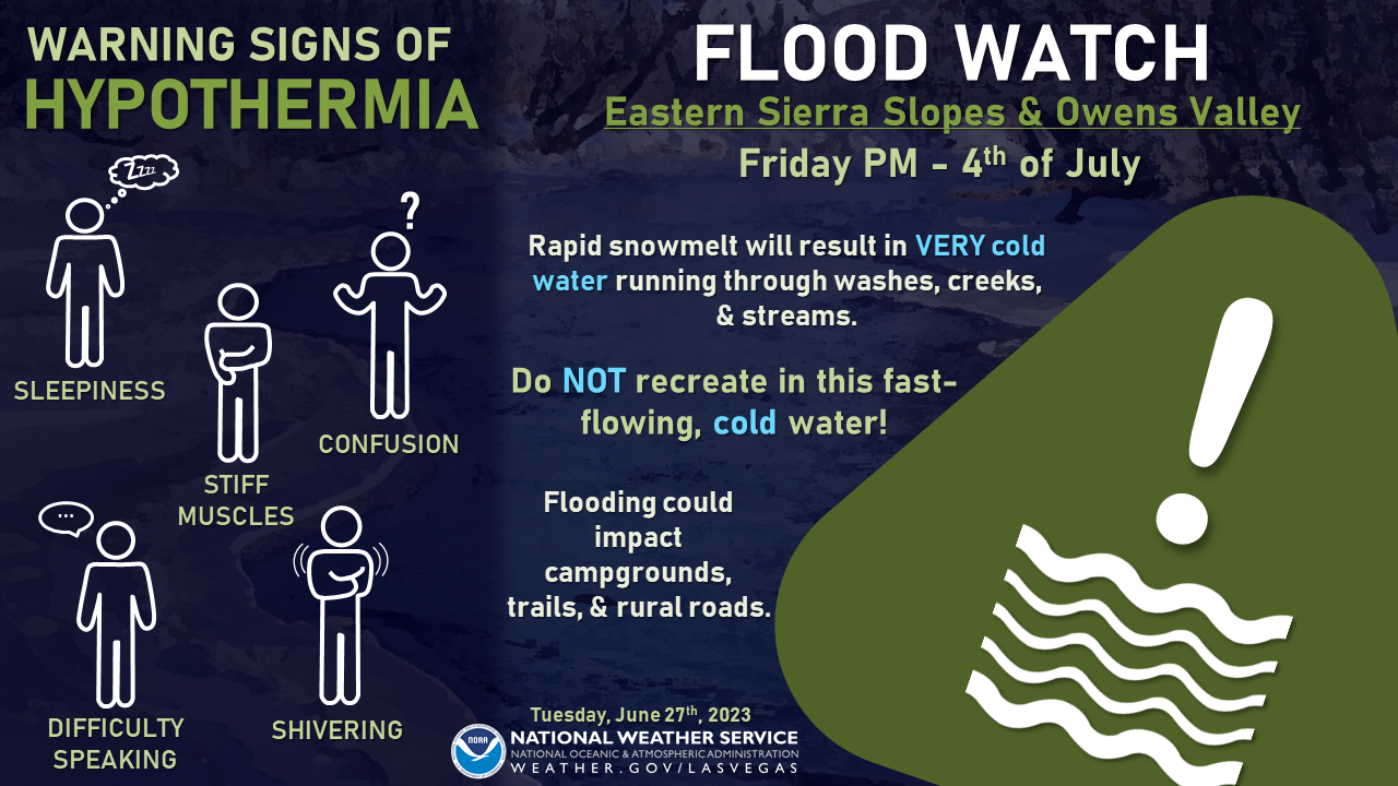
Flood Watch for Snowmelt
National Weather Service – Las Vegas, NV
Please find the attached weather briefing for the Flood Watch for Snowmelt which is in effect from Friday evening through Tuesday, July 4th.
Key Points:
- The warmest temperatures so far this year are expected for the southern Sierra over the holiday weekend.
- Excessive runoff due to rapid snowmelt may result in flooding of rivers, creeks, streams and other low-lying and flood-prone locations.
ALSO SEE NWS FLOOD WATCH NOTICE AS PDF BELOW IN RELATED INFORMATION

Kaibab NF fire lines hold through Red Flag days
Related Incident: Hull FireRidge FireThree Lakes Fire
Publication Type: News
Williams, Ariz., June 28, 2023 – Fires on the Kaibab National Forest held within fire lines through two days of Red Flag conditions. Temperatures near 80°F, single-digit humidity, and sustained winds over 20 mph with gusts up to 40 mph created conditions conducive to rapid wildfire spread. However, all three fires stayed within the planned area perimeters, a testament to prior forest thinning projects, previous applications of fire on the landscape, and the skill and vigilance of fire managers and crews on-scene who, knowing these conditions were coming, have been making strategic decisions about where and when to conduct tactical firing operations and establish fire lines.
Slightly cooler temperatures, decreased winds, and higher humidity levels are forecast to return later this week, which could give crews on the Ridge and Three Lakes fires the opportunity to resume tactical firing operations and continue managing the lightning-caused fires for forest health within their planned areas. As activity on the Hull Fire decreases, crews will shift the focus on repairing and rehabilitating handlines dug to protect areas within the planned area, such as the historic Hull Cabin, while continuing to patrol and hold perimeters.
Hull Fire: 1,491 with no growth within the planning area – Twenty-five personnel are currently assigned to this fire.
Ridge Fire: 2,603 acres with slow growth within the planning area - Seventy-five personnel are assigned to this fire.
Three Lakes Fire: 1,037 acres with slow growth within the planning area – Ninety personnel are assigned to this fire.
More details on each fire can be found on InciWeb.
Managing naturally caused wildfires across the landscape is a very effective tool in restoring the forest to a healthier condition, and these efforts align with the Forest Service's 10-year Wildfire Crisis Strategy, which aims to increase the use of fire on the landscape as well as other treatments to improve forest resiliency for generations to come.
Additional information can be found on the Kaibab NF website, Twitter, Facebook, Flickr, or by calling the Fire Information Hotline at 928-635-8311 or local ranger stations.
June 28 2023 Update
Related Incident: Comanche Fire
Publication Type: News
Note: This will be the second to last update unless fire activity picks up. The last update will be Friday.
Northern New Mexico Type 3 Incident Management Team
Luke McLarty/Steven Griego, Incident Commander
Fire Information: 505-418-1038
2023.comanche@firenet.gov
https://inciweb.nwcg.gov/
Upcoming Actions: Fire crews are working with resource advisers to rehabilitate areas affected by fire management activity. Crews are focused on suppression repair work, including reseeding, fixing fences, installing erosion control features and closing dozer lines. Fire activity has reduced significantly, and crews continue to patrol by gridding for hotspots and cooling them for further control.
The naturally caused Comanche Fire has had the desired ecological effects in the areas it has burned, cleaning up the understory and allowing for better forest health.
Smoke: Smoke may be visible from Canjilon, Abiquiu, El Rito and as far as Santa Fe and Taos. It may impact the communities of Abiquiu, El Rito, Medenales, Hernandez and the Española Valley. Temporary smoke monitors have been placed at the El Rito Ranger Station, Ghost Ranch in Abiquiu and the Chevron station in Hernandez. Air quality data is available from the Fire and Smoke Map at fire.airnow.gov.
Special Messages: There is a Temporary Flight Restriction (TFR) over the fire area. For the safety of aerial resources and fire crews on the ground, please do not fly drones in the fire vicinity. If you fly, we can’t.
Closure: Temporary partial road closures are in effect on Forest Roads 137 and 20.
Fast Facts
Size: 1,974 acres
Cause: Lightning
Fuels: Ponderosa pine and mixed conifer Values at risk: Cultural/historical sites.
Percent Completed: 50%
Resources: 1 hand crew, 2 wildland fire modules, 4 engines, 1 grader, 2 water tender, 1 REMS teams, total personnel 117
20230628RicoFireUpdate
Related Incident:
Publication Type: News
This is the LAST Update for the Rico Fire - June 28th
Rico Fire Update – June 28, 2023
Location: ¼ mile NW of Pinos Altos, NM I Size: 328 acres I Containment: 70% I Personnel: 141
Start Date: June 20, 2023 I Cause: Under investigation I Fuels: Slash, timber and brush
This is the last DAILY update for the RICO FIRE
SILVER CITY, NM, June 28, 2023 – This is the last daily update for the Rico Fire. Following the standard naming convention for wildfires, the “Rico Fire” was named after a nearby geographical feature, Arroyo Rico. Today is considered a transition day, as the Albuquerque Zone Incident Management Team transfers command of the fire to Incident Commander, Jesse Holguin from the BLM. Holguin will oversee a less complex incident with the appropriate number and type of resources to complete the work that remains. Many resources are strategically “released” from the fire at this stage, however the Incident Commander can exercise his authority to request or release resources, as needed. Public Information Officers are being released and will no longer be running traplines nor issuing daily fire updates.
Situational Awareness Reminder for All: Fire season has arrived in the Southwest. Be aware of the conditions in and around the places you live, work and play. Lightning-caused fires can strike anywhere, at any time, and so can human-caused fires. Be aware, alert and informed. Become familiar with the New Mexico Fire Information website: NMFireInfo for statewide information on Fire Restrictions, tips on fire prevention and wildfire smoke emissions that may affect your health. This site also hosts current fire information on active fires in New Mexico.
Bear Creek Road is not closed: Please reduce speed and proceed with caution as firefighting operations are ongoing. There is still high use of firefighter traffic on Bear Creek Road.
Road Closure Status: There are NO ROAD CLOSURES associated with the Rico Fire.
Residual Smoke: Expected to settle into lower elevations. Smoke sensitive individuals who want to learn more should follow recommendations at NMFireInfo Smoke Management
For more information: visit NMFireInfo or the Inciweb direct link to the Rico Fire
Rico Fire Information: 575-323-1533, 8 am - 4 pm, the fire information phone line will be deactivated at 4 pm today.
Pass Fire update for June 28 2023
Related Incident:
Publication Type: News
Acres: 57,100 (estimated)
Start Date: May 18, 2023
Location: 40 miles west of Winston, NM
Cause: Lightning
Containment: 12%
Fuels: Timber, piñon/juniper and grass
Personnel: 168
The Pass Fire showed minimal growth yesterday. Infrared flights have not been possible for the past two days; mapping accuracy will improve with the next infrared mission. Most firefighter efforts are focused along southeast side of the fire perimeter, near the East Fork of the Gila Rive and Trails End Ranch and Fowler Ranch.
Fire danger is increasing under hot, dry weather conditions as the Fourth of July holiday approaches. Check for fire restrictions before heading out to public lands. If they are allowed and weather permits, you must watch your campfire at all times, or extinguish it fully when it is not attended. Douse with plenty of water, stir it into the coals, and feel for heat with your bare hand. When you can safely touch the coals, the fire is out. Hot coals equal hot fire.
Today, crews will continue preparations along Forest Road 704, White Rocks Trail (27), and Iron Trail (771) to be utilized as part of the containment line, keeping the fire within the identified planning area. Additional use of hand ignition operations may occur to remove available fuels between the active fire and containment features. As part of the structure protection efforts, firefighters are installing hoses and sprinkler systems around private structures ahead of the fire. The Pass Fire is being monitored by air and ground. One Type 1 and two Type 3 helicopters remain available to be used to deliver water over hot spots if needed as well as for reconnaissance flights and supply missions.
There are no road, trail, or campground closures in place on the Gila National Forest. Smoke from the Pass Fire is settling in the lower valleys at night and early morning, but with cloud cover, smoke may take longer to lift and clear.
The overall strategy on the Pass Fire is to allow the low to moderate intensity of the fire to play its natural role on the landscape as firefighters take appropriate actions to keep the fire within the designated planned boundaries while protecting private land, infrastructure, and natural resources. The Gila National Forest is a fire-adapted ecosystem. It is dependent on fire to maintain forest and fuels conditions, reducing the frequency of catastrophic fires in the future.
Weather: Mostly sunny, with highs of 84 to 90. Light winds of 10 - 15 mph and minimum relative humidity around 14%. Slight (10%) potential for afternoon thunderstorms. Elevated fire danger today and tomorrow.
Aviation Restrictions: A Temporary Flight Restriction (TFR) is still in place over the Pass Fire. All non-fire aircraft are restricted. This includes civilian drones. Unauthorized aircraft in the area will ground firefighting aircraft, hindering firefighting efforts. If you fly, we can’t.
For More Information:
- Inciweb: https://inciweb.wildfire.gov/incident-information/nmgnf-pass-fire
- New Mexico Fire Information: https://nmfireinfo.com/
- Air Quality: https://www.airnow.gov
Thomas Mountain Broadcast Burn San Jacinto Ranger District 62823
Related Incident: 2023 - San Bernardino National Forest Wildfire Crisis Response
Publication Type: News
June 28, 2023 – The San Jacinto District is still working the prescribed burn on Thomas Mountain. Crews have completed the ignitions for the Thomas Mountain Prescribed Burn, and their attention has shifted to mopping up and maintaining the containment lines for the next several weeks.
During this phase, it is normal for visitors and residents to continue seeing smoke in the area. The fire will naturally continue to consume fuels within the designated footprint. This process helps reduce excess vegetation and promotes ecological health in the area.
During these operations certain areas will be temporarily closed to the public: Forest Road 6S13, Tool Box Springs Yellow Post Sites, Thomas Mountain Yellow Post Sites, and the Ramona Trail. These closures are implemented for the safety of both the public and firefighters involved in the operations.
Prescribed fire plays an important role in forest health and in reducing extreme wildfires and their negative impact. These fires also help reduce heavy fuel loads while simultaneously opening the conifer forest structure and maintaining the health of meadow habitats. Fire is also used to enhance native plant communities and cultural landscapes and improve wildlife habitats. Another goal is to provide defensible space for communities and developed areas within and surrounding the BDF. With all fire comes smoke, and the U.S. Forest Service works to mitigate smoke impacts from prescribed fires on the communities in the area.
#PrescribedBurn #PrescribedFire #ForestHealth #thomasmountainprescribedburn
Stanislaus NF to Wind Down Spring RX Fire Operations on Summit District News Release
Related Incident: 2023 - Strawberry Prescribed Burn, Summit Ranger District, Stanislaus National Forest2023 - Dry Meadow Prescribed Burn, Summit Ranger District, Stanislaus National Forest2023 - Experimental Forest, Stanislaus National Forest2023 - South Fork Prescribed Burn, Summit Ranger District, Stanislaus National Forest
Publication Type: News
SONORA, California June 27, 2023 – With more than 4,000 acres treated with prescribed fire in the Strawberry, Dry Meadow, South Fork, and the Experimental Forest burn units complete and an extended warming trend entering the area, prescribed fire operations on the Summit District for the Spring season have come to a close.
“I can’t express enough how proud I am of the sheer volume of work that’s been completed over the last five weeks,” said Stanislaus National Forest Supervisor, Jason Kuiken. “We’ve really been able to show that with the right conditions and the availability of resources that were made available to us, that we are able to put fire on the ground at the pace and scale needed to properly reduce the risk to our communities and protect the critical infrastructure our community relies upon.”
In addition to the acres treated with prescribed fire, crews from all over California were able to prep more than 5,000 acres in the North Beardsley burn units for prescribed burn operations in the fall season. If conditions are favorable, the Stanislaus National Forest will also look to burn higher elevation locations with the North China burn plan.
Over the next week, firefighters will continue with mop up and patrol of the four different burn units. Patches of fuels within the unit lines will continue to smoke, especially in the recently burned units (S04 and S09 units close to the Pinecrest School, and along Crabtree Road). Crews continue to patrol other units on the project that were burned several weeks ago.
More than 1000 firefighters have been on the Stanislaus National Forest since prescribed fire operations began on May 26. The prescribed burn operation supports the Forest Service’s Wildfire Crisis Strategy which combines a historic investment of congressional funding with years of scientific research and planning into a national effort that will dramatically increase the scale and pace of forest health treatments over the next decade. Through the strategy, the agency will work with states, Tribes and other partners to addresses wildfire risks to critical infrastructure, protect communities, and make forests more resilient.
Settings - change map background and toggle additional layers
Filter - control incident types displayed on map.
Zoom to your location
Reset map zoom and position
Could not determine your location.
Show Legend
 Wildfire
 Prescribed Fire
 Burned Area
Response
Burned Area
Response Other
Other