
NearRed Flag conditions limit tactical firing operations on the Hull and Ridge fires
Related Incident: Ridge FireHull Fire
Publication Type: News
Tusayan, Ariz., June 24, 2023 — Sustained winds of 20 miles-per-hour and humidity levels dropping into the single digits have brought near-Red Flag conditions to the Tusayan area. Crews are improving protections, monitoring the fire for increased activity, and ensuring the fire stays within the designated area.
Fire managers are taking advantage of the unseasonably mild weather conditions to use the fires in a manner that benefits forest health. Crew are applying fire along selected and prepared forest roads on either side of and ahead of the fires. This removes fuels and creates a buffer along the planned area, allowing fire to move slowly and naturally through the interior while mitigating opportunities for escaping beyond the control lines. Both fires are in and surrounded by areas which have experienced prescribed and natural fire.
The forecast through the weekend and into next week calls for steadily increasing temperatures, low humidity levels, and light and variable winds. Weather will continue to play a vital role in how these fires are managed, with tactical firing operations continuing only when conditions exist to safely do so.
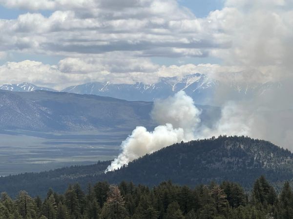
The Hull Fire, located near Lower Hull Tank along the Kaibab National Forest and Grand Canyon National Park boundary just northeast of the Grand View Lookout and east of Grandview Point, is currently at 1358 acres burning in ponderosa pine forest, slowly spreading southwest, and is being co-managed with Grand Canyon National Park. 64 personnel are currently assigned to this fire.
The Ridge Fire, located approximately 7 miles southeast of Tusayan along forest road 302 near Skinner Tank, is currently 1963 acres burning in ponderosa pine forest, and is slowly moving south of Skinner Ridge. 47 personnel are assigned to this fire.
Using naturally-caused wildfires to help improve forest health aligns with the Forest Service’s 10-year Wildfire Crisis Strategy which aims to increase the use of fire on the landscape as well as other treatments to improve forest resiliency for generations to come. Visit InciWeb pages to learn how fire crews are managing the Hull and Ridge fires to serve their natural role in the ecosystem.
Additional information can be found on InciWeb, the Kaibab NF website, Twitter, Facebook, Flickr, or by calling the Fire Information Hotline (recording) at 928-635-8311 or local ranger stations.
STF Rx Burn Update Evening June 23 2023
Related Incident: 2023 - Strawberry Prescribed Burn, Summit Ranger District, Stanislaus National Forest2023 - Dry Meadow Prescribed Burn, Summit Ranger District, Stanislaus National Forest
Publication Type: Announcement
Prescribed fire continued on the ground today on the Stanislaus National Forest Rx Burn Projects. On the Strawberry Rx Burn Unit, firing operations were completed on units S04 and S09 today (total 176 acres). Tomorrow, crews will continue to monitor and hold those units burned today as well as recently burned units along Crabtree Road.
On the Dry Meadow Rx Burn Project, crews monitored and secured lines from recently burned units, including the most recent unit DM48. Work has begun on the rehabilitation of dozer lines in the project area.
No additional burning on these large prescribed fire project areas is anticipated. Crews will work to make sure that the units continue to hold as lingering heavy fuels within the units are consumed. This monitoring will also continue on the South Fork Rx Burn Project.
Early next week, prescribed firing operations are anticipated to begin on the Stanislaus National Forest’s Experimental Forest. These units are smaller than the large project areas, with approximately 15 acres projected to be burned each day.
Tomorrow’s weather will be slightly warmer and drier. On Sunday, a gradual warming and drying trend will settle in the area.
Pinecrest is anticipated to have a few hours of medium smoke levels this evening. Further down the Tuolumne River is anticipated to have greater smoke impacts this evening.
There are a total of 534 firefighters working on these Rx Project areas. To date, a total of 4,168 acres of prescribed burning has occurred in this area of the forest.
20230624PassFireUpdate
Related Incident:
Publication Type: News
Pass Fire Update - June 24, 2023
Acres: 53,465
Start Date: May 18, 2023
Location: 40 miles west of Winston, NM
Cause: Lightning
Containment: 13%
Fuels: Timber, pinon/juniper and grass
Personnel: 79
Yesterday, stronger winds caused fire activity to increase and burn moderately through an additional 374 acres on the Pass Fire. Firefighters monitoring the fire area, determined the fire grew mostly on the southeast portion near Windfall Mesa and Green Fly trail (#26), still within the predetermined planned boundaries. Fire activity observed was backing down in small pines and ground fuel (vegetation). Firefighters are closely monitoring this area and ensuring the Pass Fire stays within the designated boundaries while protecting private property and other values at risk. Indian Creek showed no fire activity where firefighters completed securing that containment line and are assessing a nearby trail to improve for any future fire containment and control. Monitoring of the whole fire area continues as long as interior smokes still exist within the perimeter.
Hot and dry weather with gusty winds up to 30 mph will persist today making vegetation more available to burn with more growth of the Pass Fire expected.
The overall strategy on the Pass Fire is to allow the low to moderate intensity of the fire to play its natural role on the landscape as firefighters take appropriate actions to keep the fire within the designated planned boundaries while protecting private land, infrastructure, and natural resources. The Gila National Forest is a fire-adapted ecosystem. It is dependent on fire to play a natural role in restoring the landscape to more natural conditions while preventing the occurrence of extreme fires in the future.
Safety: High potential for fire today. Please use caution and stay informed on changing fire and weather conditions. There are currently no closures in place.
Weather: Sunny, with highs around 83-88 degrees. Elevated fire danger today through Tuesday. West-Southwest winds 11-21 and increasing to 20-25 mph in the afternoon with gusts up to 30 mph and no rain in the near future.
Aviation Restrictions: A Temporary Flight Restriction (TFR) is still in place over the Pass Fire. All non-fire aircraft are restricted. This includes civilian drones. Unauthorized aircraft in the area will ground firefighting aircraft, hindering firefighting efforts. If you fly, we can’t.
For More Information:
- Inciweb: https://inciweb.wildfire.gov/incident-information/nmgnf-pass-fire Inciweb is the official site for fire information. This site is secure and updated daily.
- New Mexico Fire Information: https://nmfireinfo.com/
- Air Quality: https://www.airnow.gov
Thomas Mountain Broadcast Burn San Jacinto Ranger District 62423
Related Incident: 2023 - San Bernardino National Forest Wildfire Crisis Response
Publication Type: News
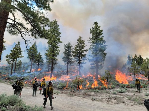
June 24, 2023 – The San Jacinto District will proceed today with the prescribed burn on Thomas Mountain. The primary objective remains consistent, focusing on working the interior of the fire and consuming the accumulated downed and dead fuels. Residents and visitors will see flames and smoke visible throughout the day and evening.
If you are traveling on California Highway 74 you may experience brief closures due to aerial operations. These closures are to protect both the firefighters involved in the operations and the public using the highway.
During these operations certain areas will be temporarily closed to the public: Forest Road 6S13, Tool Box Springs Yellow Post Sites, Thomas Mountain Yellow Post Sites, and the Ramona Trail. These closures are implemented for the safety of both the public and firefighters involved in the operations.
Prescribed fire plays an important role in forest health and in reducing extreme wildfires and their negative impact. These fires also help reduce heavy fuel loads while simultaneously opening the conifer forest structure and maintaining the health of meadow habitats. Fire is also used to enhance native plant communities and cultural landscapes and improve wildlife habitats. Another goal is to provide defensible space for communities and developed areas within and surrounding the BDF. With all fire comes smoke, and the U.S. Forest Service works to mitigate smoke impacts from prescribed fires on the communities in the area.
#PrescribedBurn #PrescribedFire #ForestHealth #thomasmountainprescribedburn
June 24 2023 Update
Related Incident: Comanche Fire
Publication Type: News
Northern New Mexico Type 3 Incident Management Team
Luke McLarty, Incident Commander
Fire Information: 505-418-1038
2023.comanche@firenet.gov
Upcoming Actions: Fire crews worked hard to successfully hold the Comanche Fire within its containment lines on Friday despite Red Flag conditions. This was possible due to the extensive planning and tactics implemented during the previous days. Increased smoke was due to interior burning.
Fire managers continue to assess and plan for various scenarios in the coming days depending on fire behavior, which is affected by weather, fuel conditions and terrain. The goal is to continue to work with this naturally caused wildfire so it can fulfill its ecological role on the landscape while responsibly adjusting to conditions.
The fire will continue to burn, but the final acreage will be less than the 10,000-acre focus area due to changing weather and vegetation drying out. Plans in place and tactics already implemented are allowing crews to manage the fire and give them the ability to slow spread and contain it safely and effectively where and when necessary.
Smoke: Smoke may be visible from Canjilon, Abiquiu, El Rito and as far as Santa Fe and Taos. It may impact the communities of Abiquiu, El Rito, Medenales, Hernandez and the Española Valley. Temporary smoke monitors have been placed at the El Rito Ranger Station, Ghost Ranch in Abiquiu and at the Chevron station in Hernandez. Air quality data is available from the Fire and Smoke Map at fire.airnow.gov.
Closure: Temporary partial road closures are in effect on Forest Roads 137 and 20 during firing operations for safety of the public and fire crews.
Fast Facts
Size: 1795 acres
Cause: Lightning
Fuels: Ponderosa pine and mixed conifer
Values at risk: Cultural/historical sites.
Percent Completed: 15%
Resources: 3 hand crews, 2 wildland fire modules, 7 engines, 1 dozer, 2 water tender, 2 REMS teams, total personnel 187
Thomas Mountain Broadcast Burn San Jacinto Ranger District 62323 Evening Update
Related Incident: 2023 - San Bernardino National Forest Wildfire Crisis Response
Publication Type: News
June 23, 2023 - Evening Update - Burn operations for today have concluded successfully. Approximately 1,592 acres have been accomplished. Crews have been able to complete both the south and north side of the Thomas Mountain Prescribed Burn.
Tomorrow the crews will focus on the interior area of the prescribed burn area. They will utilize aerial ignitions, which involve using aircraft to drop incendiary devices to help ignite targeted areas. This approach assists with containing the fire within the predetermined boundaries.
The fire is still burning within the unit and sending up smoke; at times visible from Highway 74. Crews will be monitoring and working throughout the evening. Operations will begin again tomorrow at 9am.
#PrescribedBurn #PrescribedFire #ForestHealth #thomasmountainprescribedburn
2023 French Meadows RX Daily Update 06 23 2023
Related Incident: 2023 French Meadows Rx
Publication Type: Announcement
On June 23, Tahoe National Forest and Nature Conservancy personnel conducted a 130-acre prescribed burn east of the French Meadows Dam. Wildland fire and fuels staff from the U.S. Forest Service will continue to patrol and monitor the prescription area to ensure containment lines are holding. Smoke should have minimal effects on French Meadow campgrounds throughout the weekend.
Prescription areas adjacent to today’s burn continue to be prepped for ignition, however, ignition will not be conducted until Monday at the earliest if conditions allow. Prescriptions must fall within specific weather conditions for a successful burn.
For more information and updates on the 500-acre prescribed (RX) fire visit: https://inciweb.nwcg.gov/inc.../catnf-2023-french-meadows-rx
Prescribed fire now could help prevent catastrophic wildfire later.
ANTELOPE PRESCRIBED RX BURN UPDATE JUNE 23 2023
Related Incident: INYO NATIONAL FOREST 2023 PRESCRIBED FIRE PROJECTS
Publication Type: Announcement
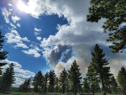
ANTELOPE PRESCRIBED (RX) BURN UPDATE - JUNE 23, 2023
Today firefighters ended up burning 245 acres at the “Antelope” RX Unit (located northeast of Mammoth) instead of the originally targeted 135. This was because weather conditions were favorable and the Great Basin Unified Air Pollution Control District had already approved the requested 300 acres for the day.
As you can see, it appears to have put up significant smoke. The photos below were taken by a Bureau of Land Management - California Archeologist who was in the Bodie Hills today. Both the Burn Boss and the Air Pollution Control District representative were in agreement that the smoke did exactly what was modeled.
Typically, emissions per acre from prescribed fire are less than those from wildfire. Air quality is considered by federal land managers during every phase of the prescribe fire process from planning to implementation. The Burn Boss, along with other fire managers do plan for and minimize smoke impacts on communities, minimize public health impacts, reduce visibility impairment on roadways, and time ignitions to avoid impacting social/economic activities.
Tomorrow, June 24, firefighters plan to continue ignitions with a target of 224 acres within the Antelope RX Unit. They estimate that they will be done with ignitions at least by Monday, likely Sunday.
This RX project is going very well, with very minimal tree torching and a desirable mosaic-pattern consumption of fuels. With fuel moistures being at record highs this year, firefighters can move though the project burning faster than in other years when it’s drier.
SEE PHOTOS POSTED AT BELOW RELATED INFORMATION OR ABOVE AT PHOTOS TAB
Thomas Mountain Broadcast Burn San Jacinto Ranger District 62323 Afternoon Update
Related Incident: 2023 - San Bernardino National Forest Wildfire Crisis Response
Publication Type: News
June 23, 2023 -Afternoon Update – You may have noticed more smoke this mid-morning through this late afternoon as weather conditions improved today, enabling the fire management team to carry out ground ignitions on the south side of the burn area. This area has been a challenge the last two day with the unfavorable winds. Subsequently, as the weather cleared up further, aerial ignition operations were conducted in the interior to consume unburnt fuels.
Additionally, the helicopter was utilized to perform water drops on certain interior areas and aid firefighters on the ground. This collaborative effort between ground and aerial resources helps enhance the effectiveness and safety of the prescribed burn operations.
The forecast of cooler temperatures and rising humidity is favorable for the ongoing management of the prescribed burn throughout the evening. These weather conditions can aid in the management of the fire, facilitating the objectives of the burn while minimizing risks.
#PrescribedBurn #PrescribedFire #ForestHealth #thomasmountainprescribedburn