
Thomas Mountain Broadcast Burn San Jacinto Ranger District 62223 Evening Update
Related Incident: 2023 - San Bernardino National Forest Wildfire Crisis Response
Publication Type: News
June 22, 2023 - Evening Update - Operations for today have concluded successfully, to date there have been 1,492 acres accomplished.
Throughout the day, the presence of smoke indicated that the fuels were still burning and actively consuming the vegetation within the interior of the fire area. Unfortunately, due to unfavorable wind conditions, the firefighters were unable to carry out prescribed burn operations. Instead, they directed their efforts towards strengthening and fortifying the existing containment lines, which were being put to the test by the strong winds. This approach aimed to prevent the fire from breaching the containment lines and spreading further into surrounding areas.
The fire is still burning within the unit and sending up smoke; at times visible from Highway 74. Crews will be monitoring and working throughout the evening. Operations will continue tomorrow at 9am.
#PrescribedBurn #PrescribedFire #foresthealth #thomasmountainprescribedburn
2023 French Meadows RX Daily Update 06222023
Related Incident: 2023 French Meadows Rx
Publication Type: Announcement
Today, Tahoe National Forest and The Nature Conservancy personnel conducted an 82-acre prescribed burn east of the French Meadows Dam in the area just above the French Meadows Campground. More ignitions are planned to continue tomorrow, June 23. The prescribed burn will not delay the opening of the French Meadows Campground. Wildland fire and fuels staff from the U.S. Forest Service will continue to patrol and monitor the prescription area to ensure containment lines are holding.
20230622RicoFireUpdate
Related Incident:
Publication Type: News
Rico Fire Update – June 22, 2023
Location: ¼ mile NW of Pinos Altos, NM I Size: 421 acres I Containment: 0% I Personnel: 170
Start Date: June 20, 2023 I Cause: Under investigation I Fuels: Slash, timber and brush
SILVER CITY, NM, June 22, 2023 – The Rico Fire has grown to 421 acres yet remains within the jurisdiction of the BLM and NM State lands. Extensive work continues as firefighters extinguish hot spots within the interior of the fire and progressively work to reinforce containment lines. Percent of containment will be reported only when there is certainty that the fire cannot cross the containment line. Laborious work goes into this the task of bolstering the lines around the entire perimeter of the fire, most of it accomplished with firefighting hand tools.
The Albuquerque Zone Type 3 Incident Management Team, led by Incident Commander Dorian Soliz, assumed command of the Rico Fire this morning at 6 a.m.
George Ducker, NM Forestry Division Public Information Officer reminds us all of the importance of Protecting Your Home from Wildfire especially in wildland urban interface settings.
Aviation Restrictions: A Temporary Flight Restriction (TFR) remains in place over the Rico Fire. All non-fire aircraft are restricted. This includes civilian drones. Unauthorized aircraft in the area will ground firefighting aircraft, hindering firefighting efforts.
Residual Smoke is expected to settle into the valley, possibly impacting Silver City and surrounding areas. Residents are advised to close their windows. Smoke sensitive individuals and anyone who wants to learn more should follow recommendations at NMFireInfo Smoke Management
Road Closure Status: State Highway 15 between Silver City and Pinos Altos is OPEN.
Check for additional information/updates at NMFireInfo.com or the Inciweb direct link to the Rico Fire
Contact: Rico Fire Information at 575-323-1533 8am to 8pm or email Loretta_Benavidez@firenet.gov
STF Rx Burn Update Afternoon June 22 2023
Related Incident: 2023 - Strawberry Prescribed Burn, Summit Ranger District, Stanislaus National Forest2023 - Dry Meadow Prescribed Burn, Summit Ranger District, Stanislaus National Forest
Publication Type: Announcement
Please be advised that a portion of Crabtree Road is anticipated to be closed at least through Friday due to prescribed fire operations. The Crabtree Road will be closed from Highway 108 to the intersection of Forest Road 4N11/4N26. This closure is to protect the safety of firefighters as well as the public during firing along the road.
Prescribed burning will continue today in the Strawberry Prescribed Burn Project area (along Crabtree Road). The units that are planning to be burned today are S05, CS5, and possible S04. In the Dry Meadow Rx Burn Project area, DM 48 is anticipated to be burned today. See map for reference.
The Strawberry and Pinecrest Academy areas are anticipated to experience heavy smoke this morning. After the smoke lifts in the afternoon, smoke is expected to return to a medium level. Sensitive individuals need to limit or avoid long or intense outdoor activities. For more information on wildland fire air quality, please visit: https://www.airnow.gov/air-quality-and-health/
An update will be provided when Crabtree Road is open.
20230622PassFireUpdate
Related Incident:
Publication Type: News
Pass Fire Update - June 22, 2023
Acres: 53,091
Start Date: May 18, 2023
Location: 40 miles west of Winston, NM
Cause: Lightning
Containment: 13%
Fuels: Timber, pinon/juniper and grass
Personnel: 54
Last night’s infrared flight showed little to no fire activity on the slow-moving or (low intensity) Pass Fire with just an acre of growth. Firefighters on the ground found downed logs smoldering around Jordan Hot Springs. A couple of wispy white columns of smoke are visible from the Clinton P. Anderson overlook on N.M. Highway 15.
Firefighters remain vigilant in checking all sides of the Pass Fire to keep it within the designated boundaries, as it slowly cleans forest understory. Detailed weather forecast and fuel samples taken by firefighters throughout the day help monitor conditions around the fire area.
The Pass Fire will not be completely out until a soaking rain event occurs. Stumps, roots, and downed logs will continue to smolder until then.
The overall strategy on the Pass Fire is to allow the low to moderate intensity of the fire to play its natural role on the landscape as firefighters take appropriate actions to keep the fire within the designated planned boundaries while protecting private land, infrastructure, and natural resources. The Gila National Forest is a fire-adapted ecosystem. It is dependent on fire to play a natural role in restoring the landscape and wildlife to more natural conditions while preventing the occurrence of more extreme fires in the future.
Fire season is now upon us. Visitors to the forest are reminded that hazards always exist. Please use caution and stay informed on changing fire and weather conditions. There are currently no closures in place.
Weather: Sunny, with highs around 83 degrees. Southwest winds around 14 mph increasing to 16-21 mph in the afternoon with gusts to 30 mph.
Aviation Restrictions: A Temporary Flight Restriction (TFR) is still in place over the Pass Fire. All non-fire aircraft are restricted. This includes civilian drones. Unauthorized aircraft in the area will ground firefighting aircraft, hindering firefighting efforts. If you fly, we can’t.
For More Information:
- Inciweb: https://inciweb.wildfire.gov/incident-information/nmgnf-pass-fire Inciweb is the official site for fire information. This site is secure and updated daily.
- New Mexico Fire Information: https://nmfireinfo.com/
- Air Quality: https://www.airnow.gov
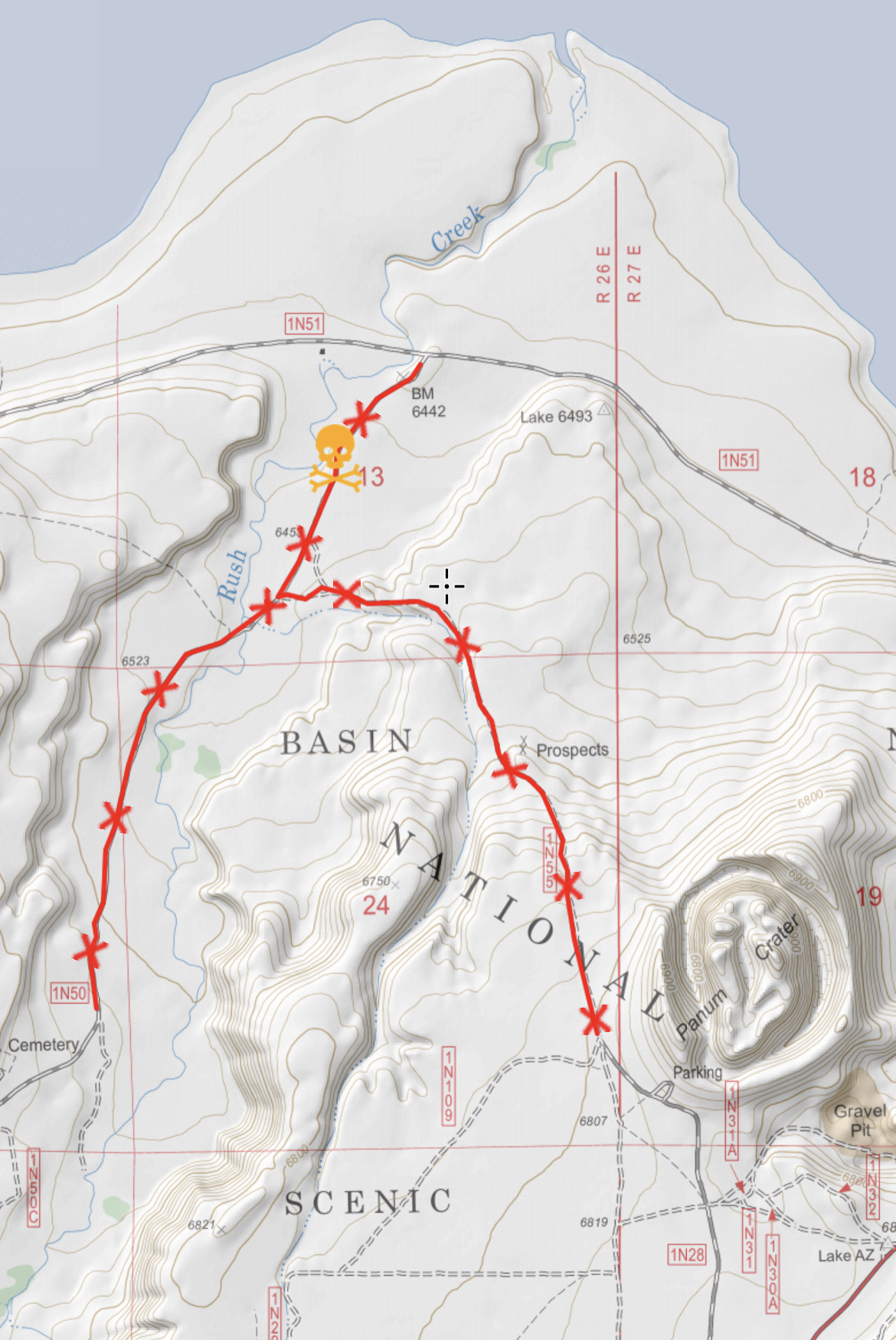
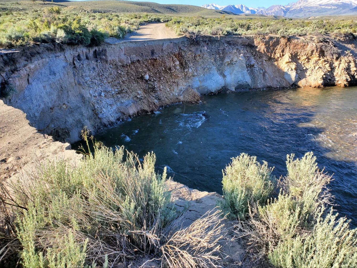
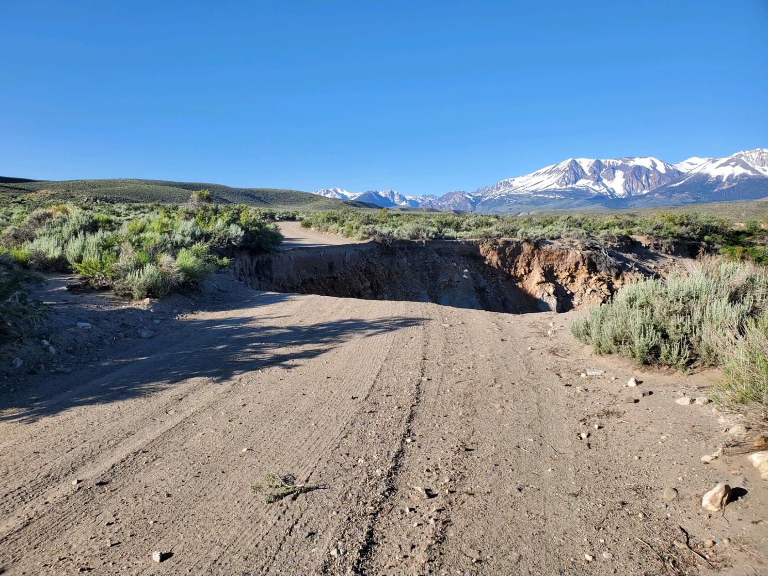
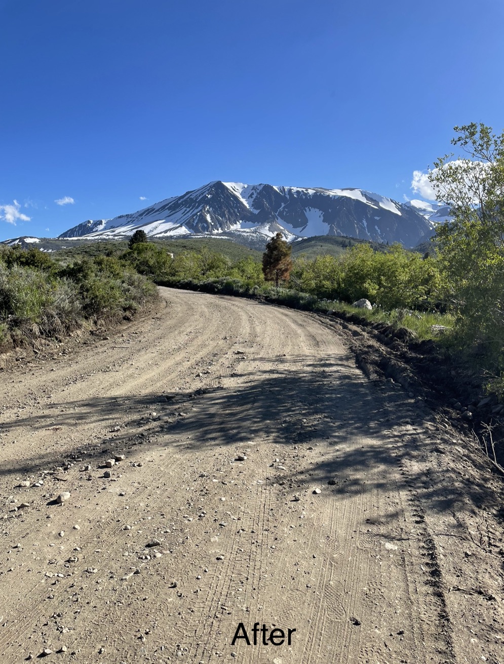
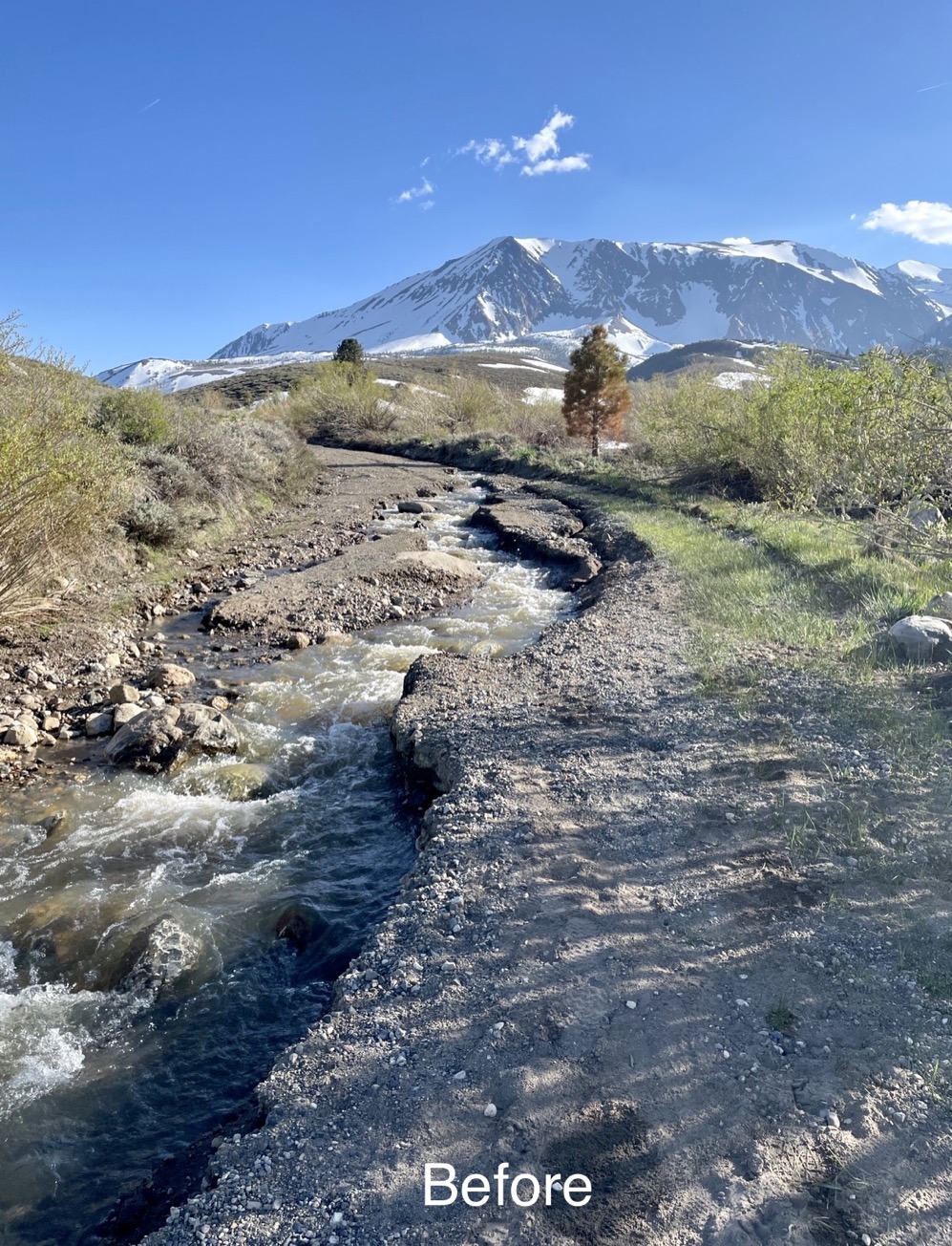
Major Washout on FS 1N50 Rush Creek Road
Related Incident: INYO NATIONAL FOREST--FLOOD RESPONSE
Publication Type: Announcement
There is a major washout on 1N50 (Rush Creek Road) at location coordinates 37.94436, -119.06095. The road washout was caused by the high flows on Rush Creek. A large section of road has collapsed into the water. We are working with the county and closing the FS 1N55 Road just north of Panum Crater Trailhead to keep vehicles from going down and not being able to get back out.
See link to photos below under related information or at the top under the Photos Tab.
June 22 2023 Update
Related Incident: Comanche Fire
Publication Type: News
Northern New Mexico Type 3 Incident Management Team
Luke McLarty, Incident Commander
Fire Information: 505-418-1038
2023.comanche@firenet.gov
https://inciweb.nwcg.gov/
Upcoming Actions: Fire crews will continue hand ignitions along the perimeter edge, continuing work from yesterday where the northwest and eastern perimeters were blacklined. These actions help create depth on the containment line to keep the fire within the focus area. A meteorologist, strategic operational planner and other specialists are assigned to the incident to directly advising incident command staff on weather and conditions.
The Carson National Forest is actively managing the naturally-ignited Comanche Fire to improve forest health, which is linked to water quality and quantity downstream. Learn more about the collaborative Rio Chama project at https://232partnership.org/rio-chama-cflrp.
Smoke: Smoke may be visible from Canjilon, Abiquiu, El Rito and as far as Santa Fe and Taos. It may impact the communities of Abiquiu, El Rito, Medenales, Hernandez and the Española Valley. Temporary smoke monitors have been placed at the Española Ranger Station, El Rito Ranger Station and at Ghost Ranch in Abiquiu. Air quality data is available from the Fire and Smoke Map at fire.airnow.gov, where smoke can be tracked.
Community Open House: Drop in between 5 and 7 p.m. today (Thu., Jun. 22) at the El Rito Senior/Community Center at State Rd. 554, House #1115. Presentation at 6 p.m.
Closure: Temporary partial road closures are in effect on Forest Roads 137 and 20 during firing operations for safety of the public and fire crews.
Fast Facts
Size: 399 acres
Cause: Lightning
Fuels: Ponderosa pine and mixed conifer Values at risk: Cultural/historical sites.
Percent Completed: 1%
Resources: 3 hand crews, 2 wildland fire modules, 6 engines, 1 dozer, 2 water tender, 2 REMS teams, total personnel 186
Thomas Mountain Broadcast Burn San Jacinto Ranger District 62223
Related Incident: 2023 - San Bernardino National Forest Wildfire Crisis Response
Publication Type: News
June 22, 2023 - The San Jacinto District will be continuing the prescribed burn today on Thomas Mountain. Residents and visitors will see flames and smoke visible throughout the day and evening.
If you are traveling on California Highway 74 you may experience brief closures due to aerial operations. These closures are to protect both the firefighters involved in the operations and the public using the highway.
During these operations certain areas will be temporarily closed to the public: Forest Road 6S13, Tool Box Springs Yellow Post Sites, Thomas Mountain Yellow Post Sites, and the Ramona Trail. These closures are implemented for the safety of both the public and firefighters involved in the operations.
Prescribed fire plays an important role in forest health and in reducing extreme wildfires and their negative impact. These fires also help reduce heavy fuel loads while simultaneously opening the conifer forest structure and maintaining the health of meadow habitats. Fire is also used to enhance native plant communities and cultural landscapes and improve wildlife habitats. Another goal is to provide defensible space for communities and developed areas within and surrounding the BDF. With all fire comes smoke, and the U.S. Forest Service works to mitigate smoke impacts from prescribed fires on the communities in the area.
#thomasmountainprescribedburn
Parker Lake Road FS 1S25 is Open with Access to Trailhead
Related Incident: INYO NATIONAL FOREST--FLOOD RESPONSE
Publication Type: Announcement
Parker Lake Road (FS 1S25) is back open with access to Parker Lake Trailhead. Thank you to Mono County and LADWP for repairs of road and blown culvert.
See link to photos below under related information or at the top under the Photos Tab.
![]()
![]()
South Fork Kern River Road Crossing at Monache Meadows Flooded
Related Incident: INYO NATIONAL FOREST--FLOOD RESPONSE
Publication Type: Announcement
South Fork Kern River last week in Monache Meadows--a road used to cross here.
See photo link below under related information or at the top under the Photos Tab.
![]()