
Spring Creek Fire Daily Update Tuesday July 4
Related Incident: Spring Creek Fire
Publication Type: News
Spring Creek Fire Update
July 4, 2023
Rocky Mountain Area Complex Incident Management Team Two
Jared Hohn, Incident Commander
Date Reported: June 24, 2023
Cause: Under Investigation
Size: 2,932 acres
Containment: 37%
Total Personnel: 538
Location: Southwest of Parachute, CO
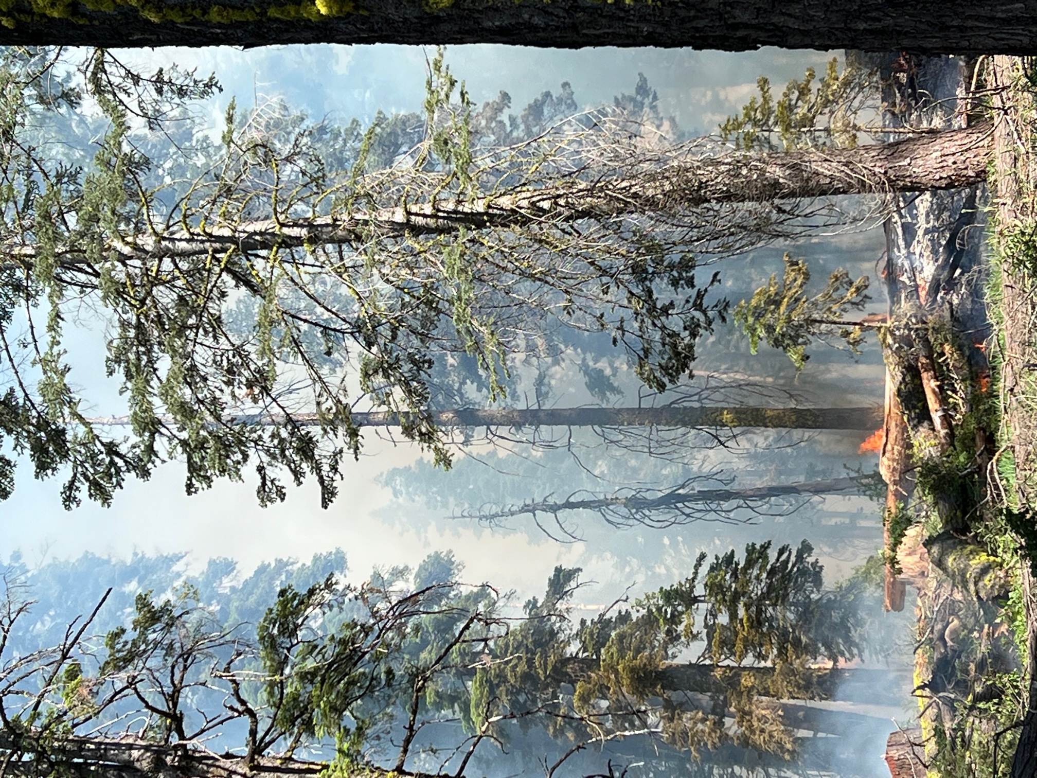
Current Situation: The Rocky Mountain Complex Incident Management Team Two carefully prepared for today’s Red Flag Warning by adapting tactical plans. While the exact challenges the weather conditions may bring today are unknown, fire managers have created a plan of action by studying the dryness of area vegetation, carefully assessing the topography of the area, and using computer modeling to predict possible fire behavior.
Yesterday, firefighters again cooled hot spots along the perimeter of the fire and built line by hand and heavy equipment. Crews removed brush along roadsides to create fire barriers. Their efforts gained containment and slowed the growth of the Spring Creek Fire. These fire control measures will be tested by the predicted weather, but firefighters have prepared for it by placing supplies like hoses, pumps, and water tanks at advantageous locations; scouting out and marking safe travel corridors for personnel and vehicles; and developing safety plans to protect firefighters in emergency situations.
Contingency plans are developed in case the primary fire controls do not suffice. One contingency plan designed to further protect the populated areas on the north side of the fire is the clearing of vegetation along the gravel road north of Dry Creek Road. This provides a second fuel break between the fire and developed areas as an additional defensive tactic.
Spring Creek Road and High Mesa Road are open to local traffic only. Please avoid these areas if possible and drive with caution because of increased fire traffic on the roadway.
Weather & Smoke Information: Temperatures and winds will increase today, and the fire will become more active after the inversion breaks around 11:00 a.m. A Red Flag Warning is in effect from noon to 9 p.m. on July 4th. Gusts of wind up to 45 mph are predicted. Over the next few days, the temperatures will remain near 90° F. Winds will calm on Wednesday but increase again Thursday thru Saturday. Residents are asked to help reduce any new fire starts during the holiday’s critical fire weather that would pull resources away from the Spring Creek Fire.
Closures: Bureau of Land Management Colorado River Valley Field Office and US Forest Service White River National Forest have public land closure orders in place for the safety of public and firefighters.
Visit BLM Colorado River Valley Field Office and U.S. Forest Service – White River for closure orders.
Evacuations: There are no evacuations at this time. Residents are encouraged to register with Garfield County's emergency notification system at: Garfield County Emergency Communications Authority (garco911.com). All evacuation orders will be conducted through the Sheriff's office. Call recorded message line at 970-981-3401 for current evacuation information
Fire Information Phoneline: (970) 414-1772 Time: 8 a.m.–9 p.m.
Media inquiries: (970) 414-1665 Time: 8 a.m.–9 p.m.
Facebook: Spring Creek Fire 2023 Email: 2023.springcreek@firenet.gov InciWeb: Spring Creek Fire Information
Storage Fire Daily Update July 04 2023
Related Incident: Storage Fire
Publication Type: News
Storage Fire Final Update
Tuesday, July 04, 2023
Size: 950 acres
Containment: 95%
Start Date: June 28, 2023
Cause: Under Investigation, Human Caused
The Storage Fire, burning south of Possum Kingdom Lake and 9 miles west of Palo Pinto in Palo Pinto County, started on June 28, 2023. The fire is suspected to be human caused and is under investigation. The fire is burning in brush, grass and mesquite mix, and is showing low to moderate fire behavior now. This will be the final update for the Storage Fire.
Evacuations: There are currently no evacuations in place for the Storage Fire. Residents are advised to use caution when reentering area as there will be trees and power poles weakened by the fire's passage. Residents may also continue to see smoke and even small flames for the near future as the fire continues to burn within the burned area.
Two buildings were damaged by this fire, but no injuries have been reported.
Yesterday: Fire crews continued to patrol and mop-up the perimeter of the fire and identified a few areas of heat or active flames. These heats were put out by engine crews with water and hand tools. Heavy Equipment crews worked to repair containment lines and then rehabilitated their equipment and staged for initial attack, or new fire starts. Additionally, most of the remaining resources were released from the incident and returned to their home units to be ready for new fire starts.
Today: The Storage fire will be monitored by resources from the local Texas A&M Forest Service office. They will be patrolling the fire area, identifying any areas of heat, and putting them out as they are identified. A dozer crew is staged at this fire, available and ready to respond to any new fires that may start. With the expected weather today, and the low activity observed yesterday, crew’s feel confident on reaching 100% containment this evening.
Weather and Fire Behavior: Temperatures will reach the upper 90s today, with winds reaching somewhere between 10-15 miles per hour. Relative humidity is expected to remain above 30%. Some thunderstorms may develop this afternoon with lightning and gusty outflow winds. These should disperse before this evening along with relative humidity remaining above 80% overnight.
Fire Information
Adam Turner
Public Information Officer, Texas A&M Forest Service
Email: adam.turner@tfs.tamu.edu
Phone: 940-328-9158
Inciweb: https://inciweb.wildfire.gov/incident-information/txtxs-storage-fire
Facebook: https://www.facebook.com/AllHazardsTFS
Twitter: https://twitter.com/AllHazardsTFS
Bone Lightning Fire Update July 3
Related Incident: 2023 - Bone Lightning Fire
Publication Type: News
Today, fire personnel completed burning operations on the northeast side of 2N05. The area is dense with large down woody debris. Fire is used to reduce hazardous fuels in the unit.
Fire personnel prepped and improved the western boundary of the fire along 3N01. Working from the north and coming up from the south, fire personnel identified and felled trees that could be hazardous and potentially impede containment efforts once burning operations begin in this unit.
More resources showed up today including one Hot Shot crew and one Forest Service engine bringing the total workforce to 110 personnel to assist in the safe burning implantation of the Bone Lightning Fire.
Tunnel Five Fire Morning Update 070323
Related Incident: Tunnel Five Fire
Publication Type: News
SE Washington Incident Management Team 1
Incident Commander: Leonard Johnson / Ryan Nicholls, Trainee
TUNNEL FIVE INCIDENT FACTS
Incident Start Date and Time: July 2, 2023 11:19AM
Location and Jurisdiction: Skamania County Fire District 3
Size: 533 acres
Containment: 0%
CURRENT SITUATION
Skamania County Firefighters responded to reports of a wildfire yesterday, July 2 at approximately 11:19AM. Hot, windy conditions coupled with extreme terrain led to rapid fire spread into the afternoon.
SE Washington Incident Management Team 1 arrived and assumed command of the fire last night. The fire was active throughout the night but stayed within its footprint along much of the perimeter with moderate growth on the west flank, west of tunnel five.
More firefighting resources from numerous agencies are arriving throughout the day. Priorities are to provide for public and firefighter safety while protecting structures, critical infrastructure, and natural resource values at risk.
Firefighters are engaging in a full-suppression effort to maintain the fire east of Drano Lake, south of the east/west portion of Cook-Underwood Rd., west of the north/south portion of Cook Underwood Rd., and north of the Columbia River.
Many different aircraft will be working on the fire today as well utilizing the Columbia River for water.
The National Weather Service has issued a Red Flag Warning for Skamania and surrounding counties in effect until 2300 Wednesday for very dry and significantly unstable conditions for fire weather.
EVACUATIONS:
Level 3 Evacuations "GO NOW" have been issued for a two-mile radius around the fire. Visit Skamania County Sheriff's Facebook page at https://www.facebook.com/SkamaniaSheriff for more info. A shelter for evacuees has been set up at Skamania County Fairgrounds, 710 SW Rock Creek Dr., Stevenson, WA. Level 1 "GET READY" evacuations are in effect for Klickitat County east of the fire. Visit
https://www.klickitatcounty.org/249/Emergency-Management for more details.
State Route 14 is closed between mile markers 53-63.
Wildland fires are a "no fly zone" for drones. If you fly, WE CAN'T. Smoke and aircraft are visible within the 1-84 corridor. Travelers should use caution; recreationalists and boaters in the Columbia River in this area should use extreme caution and avoid areas with aircraft dipping in the river.
Tunnel Five Fire Evening Update 070323
Related Incident: Tunnel Five Fire
Publication Type: News
Firefighters on the Tunnel Five fire have been working this afternoon to clear overgrown vegetation and deploy hose around homes to protect structures from the wildfire. Fire crews are also watching for burning debris rolling down slope, and are promptly extinguishing any of these burning rolling fuels to keep the fire from spreading. Helicopters and single engine air tankers have been dropping water to cool the fire and firefighters continue scouting for opportunities to create effective fireline. Management of the fire will transition to Northwest Team 12, a Type 2 Incident Management Team at 8 PM tonight.
Settings - change map background and toggle additional layers
Filter - control incident types displayed on map.
Zoom to your location
Reset map zoom and position
Could not determine your location.
Show Legend
 Wildfire
 Prescribed Fire
 Burned Area
Response
Burned Area
Response Other
Other
Tunnel Five Fire
Unit Information
Incident Contacts
What is a Fire Behavior Analyst FBAN
Related Incident: Spring Creek Fire
Publication Type: News
The July 3 Spring Creek Fire Update referred to the role of a Fire Behavior Analyst (FBAN) on an Incident Management Team. The person filling this role works closely with the team's incident meteorologist to predict fire activity and growth, based on weather, vegetation, topography, historical fire data, and other factors. Together, these two functions assist the team with proactive and contingency planning.
The Rocky Mountain Complex Incident Management Team 2 has two FBANs. They spend part of the day in planning meetings and running computer models, but also observe fire behavior in the field.
Pass Fire update for July 3 2023
Related Incident:
Publication Type: News
Pass Fire Update July 3, 2023
Acres: 59,367
Start Date: May 18, 2023
Location: 40 miles west of Winston, NM
Cause: Lightning
Containment: 12%
Fuels: Timber, piñon/juniper and grass
Personnel: 140, 1 Type 1 Helicopter, 2 Type 3 Helicopters
Yesterday, crews successfully conducted hand ignitions along the Iron Trail #771. If conditions prove favorable today, they will continue to use hand ignitions off of Iron Trail #771 to increase containment around the southeast corner of the fire perimeter to provide protection to private property nearby. Firefighters are monitoring the whole fire area daily from air and ground. Increase or decrease in acreage is due more accurate mapping.
A public safety road and trail closure is in effect, including all or portions of several roads and trails that provide access to and within the perimeter of the Pass Fire. These closures include Forest Roads 704 and 4208P in their entirety, and portions of Trails 26, 27, 157, 771, and 772. The area closure and associated map can be found at Gila National Forest - Alerts & Notices (usda.gov).
Fire danger is high, and the need for fire restrictions on the Gila National Forest is reassessed daily. If campfires are allowed and weather permits, you must watch your fire at all times, or extinguish it fully when it is not attended. Douse with plenty of water, stir it into the coals, and feel for heat. Extinguished means cold to the touch with your bare hand.
Fire is a normal visitor to the Gila landscape and something with which we all have to cope. Ecosystems here are not only adapted to fire, but dependent on the frequent return of low to moderate intensity fire to maintain healthy forest, watershed, and fuels conditions. Applying a “confine and contain” strategy to the Pass Fire allows fire to play its natural role in fire-adapted forest ecosystems, while protecting private land, infrastructure, and natural resource values at risk.
Weather: Continued very warm temperatures. We will see a chance for isolated to scattered thunderstorms which could produce lightning. Winds from 5-12 mph and temperatures around 86 degrees.
Aviation Restrictions: A Temporary Flight Restriction (TFR) is still in place over the Pass Fire. All non-fire aircraft are restricted. This includes civilian drones. Unauthorized aircraft in the area will ground firefighting aircraft, hindering firefighting efforts. If you fly, we can’t.
For More Information:
- Inciweb: https://inciweb.wildfire.gov/incident-information/nmgnf-pass-fire
- New Mexico Fire Information: https://nmfireinfo.com/
- Air Quality: https://www.airnow.gov
Spring Creek Fire Public Information Officers will be at Rifles July 3rd Celebration tonight
Related Incident: Spring Creek Fire
Publication Type: Announcement
Join us tonight as Public Information Officers with Rocky Mountain Critical Incident Management Team 2 will be providing information and answering questions about the Spring Creek Fire. Fire prevention materials will also be available. We hope to see you tonight at
Rifle's July 3rd Celebration
Centennial Park 300 West Fifth Street
6:30PM-Until Dark
Three Lakes Fire burnout ops along Hwy 67 July 5
Related Incident: Three Lakes Fire
Publication Type: Announcement
Fire managers on the Three Lakes Fire are planning to conduct burnout operations along Hwy 67 south of Jacob Lake the morning of Wednesday, July 5. Taking advantage of the relatively lower winds, crews will be igniting a 1-mile stretch to secure the southeastern perimeter of the planning area prior to the return of high winds on Thursday and Friday. Smoke may briefly impact the highway. Motorists should slow down and be prepared to stop. Fire Managers are working with the Az Department of Transportation to use pilot cars if necessary. Ignitions should be complete by midday.