
Actualizacin del Incendio en la Montaa Chris 5 de Julio 2023
Related Incident: Chris Mountain Fire
Publication Type: News
Actualización del Incendio en la Montaña Chris
5 de Julio 2023
Equipo de Gestión de Incidentes del Complejo del área de las Montañas Rocosas Tres
Matt Spring, Comandante del Incidente
Fecha Reportada: 28 de Junio, 2023
Causa: Relámpago
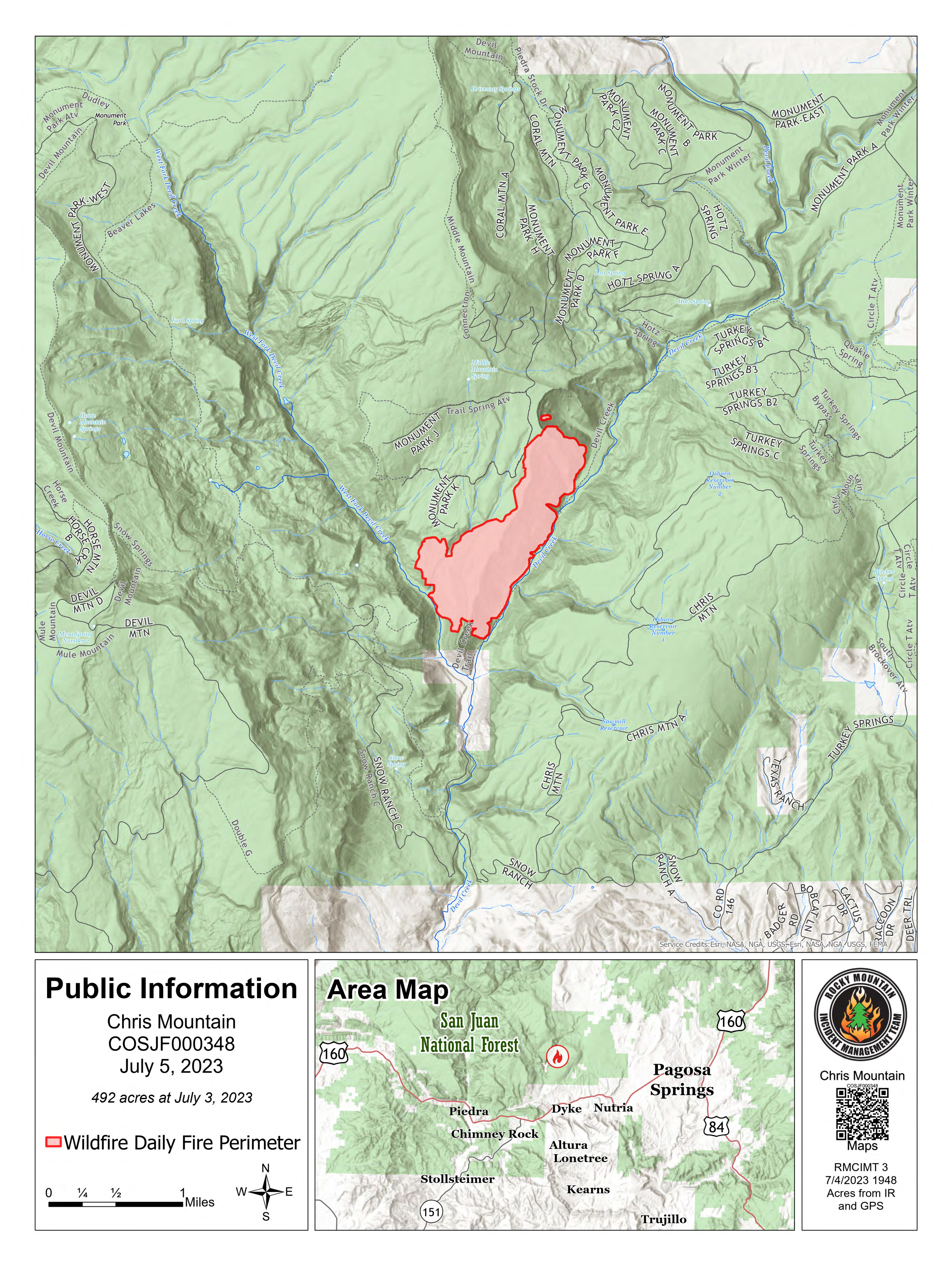
Tamaño: 492 acres
Confinamiento: 0%
Personal Total: 529
Locación: 12 millas al oeste-noroeste de Pagosa Spring, CO.
Nota Especial: Se espera que la humedad relativa estará en los dígitos individuales en el área del incendio. Se emitió una advertencia de bandera roja a nivel local para hoy, 5 de julio.
Situación Actual: Los bomberos aprovecharon las condiciones climáticas favorables para ejecutar una operación de tiro estratégico en la mañana del martes. Esta operación aseguró la línea de fuego al norte de Snow Angel Ranch al reducir el combustible no quemado entre el fuego y el rancho. Los vientos pronosticados no se desarrollaron ayer sobre el área del incendio y el crecimiento del fuego fue mínimo. Los equipos de bomberos continuaron mejorando la línea de mano en el lado oeste del incendio. Se ha observado un comportamiento mínimo del fuego en esta parte del fuego. Los helicópteros enfriaron los puntos calientes en la característica del "tazón" ya lo largo del borde del tazón en el extremo norte del incendio. La línea de fuego indirecta en el lado este del incendio está a punto de completarse. Los caminos forestales existentes, las líneas de mano y las líneas de topadoras se están utilizando para crear este perímetro. Se están desarrollando estrategias de contingencia en caso de que el fuego cruce el drenaje de Devil Creek. Los bomberos permanecieron durante la noche en el fuego patrullando y abordando los puntos calientes.
Los bomberos están mejorando y asegurando el perímetro de fuego hoy. Los equipos de bomberos están preparados para las condiciones de bandera roja pronosticadas y el aumento del comportamiento del fuego. Se han asignado recursos adicionales para responder a cualquier nuevo inicio de incendio en el área. El grupo de protección de estructuras está identificando las necesidades de mitigación en las áreas alrededor del incendio.
Información sobre el Clima y el Humo: La cobertura de nubes será mínima con una temperatura cercana a los 90 grados. Se puede desarrollar viento del suroeste de 10 a 14 mph en la tarde sobre el área del incendio. Los vientos podrían alcanzar ráfagas de hasta 25 mph en las cimas de las montañas. La humedad relativa puede ser tan baja como 8%. Estas condiciones podrían contribuir a aumentar la actividad del fuego. Se ha emitido una advertencia de bandera roja a nivel local para hoy.
Cierres: El Bosque Nacional San Juan tiene una orden de cierre vigente: https://inciweb.nwcg.gov/incident-publication/cosjf-chris-mountain-fire/chris-mountain-fire-closure.
Evacuaciones: El condado de Archuleta ha emitido evacuaciones obligatorias para Forest Road 628 a partir del 28 de junio de 2023. Para registrarse para recibir notificaciones de emergencia, visite el sitio web de Operaciones de emergencia del condado de Archuleta. También puede encontrar información sobre evacuación en su página de Facebook o llamar al Centro de atención telefónica para evacuados de Chris Mountain: al 970-264-8373.
Restricciones Temporales de Vuelo: Existe una restricción de vuelo temporal. Para más información vaya a la página: tfr.faa.gov/save_pages/detail_3_9743.html.
Línea Telefónica de Información Sobre el Incendio: (970) 549-8799 Horario: 8am – 8pm
Facebook:https://www.facebook.com/Chris-Mountain-Fire/ Correo Electrónico: 2023.chrismountain@firenet.gov
InciWeb: inciweb.nwcg.gov/incident-information/cosjf-chris-mountain-fire
Pass Fire Update for July 5 2023
Related Incident:
Publication Type: News
Pass Fire Update July 5, 2023
Acres: 59,904
Start Date: May 18, 2023
Location: 40 miles west of Winston, NM
Cause: Lightning
Containment: 32%
Fuels: Timber, piñon/juniper and grass
Personnel: 140, 1 Type 3 Helicopter
Containment on the Pass Fire has increased as fire crews accomplished work to secure containment lines along the southeastern edge of the perimeter resulting in the protection of private inholdings adjacent to the Gila National Forest. Hand ignitions performed the last couple of days allowed the fire to burn out excess vegetation along Iron Trail #771 and White Rocks Trail #27, with the goal of improving and securing containment lines. Today, firefighters will monitor and patrol the Pass Fire by ground and air to ensure those containment lines stay secured. Containment lines act as boundaries to keep the fire corralled until it is completely out.
Interior smoke is still visible from low to moderate intensity fire that is burning in No Name Canyon, approximately 1 mile northwest of Jordan Hot Springs. Conditions are expected to remain dry today with the potential of increased smoke from this area. Firefighters will continue to monitor this fire activity from air and from the Black Mountain Lookout Tower. Most of the Pass Fire area is in a patrol and monitor status. Resources on the Pass Fire are gradually being released as fire activity subsides.
A public safety road and trail closure is in effect, including all or portions of several roads and trails that provide access to and within the perimeter of the Pass Fire. These closures include Forest Roads 704 and 4208P in their entirety, and portions of Trails 26, 27, 157, 771, and 772. The area closure and associated map can be found at Gila National Forest - Alerts & Notices (usda.gov).
Fire danger is still high, and the need for fire restrictions on the Gila National Forest is reassessed daily. If campfires are allowed and weather permits, you must always watch your campfire, or extinguish it fully when it is not attended. Douse with plenty of water, stir it into the coals, and feel for heat. Extinguished means cold to the touch with your bare hand.
Weather: Sunny and dry conditions today with no chance of rain. Temperatures will be between 92-94 with light winds out of the northwest between 6-10 mph.
Aviation Restrictions: A Temporary Flight Restriction (TFR) is still in place over the Pass Fire. All non-fire aircraft are restricted. This includes civilian drones. Unauthorized aircraft in the area will ground firefighting aircraft, hindering firefighting efforts. If you fly, we can’t.
For More Information:
- Inciweb: https://inciweb.wildfire.gov/incident-information/nmgnf-pass-fire
- New Mexico Fire Information: https://nmfireinfo.com/
- Air Quality: https://www.airnow.gov
July 5 2023 Chris Mountain Fire Update
Related Incident: Chris Mountain Fire
Publication Type: News
Chris Mountain Fire Update
July 5, 2023; 9:00 am
Rocky Mountain Area Complex Incident Management Team Three
Matt Spring, Incident Commander
Date Reported: June 28, 2023
Cause: Lightning
Size: 492 acres
Containment: 0%
Total Personnel: 529
Location: 12 Mile west-northwest of Pagosa Springs, CO
Special Notes: The relative humidity is expected to be in the single digits in the fire area. A Red Flag Warning has been issued locally for today, July 5th.
Current Situation: Firefighters took advantage of favorable weather conditions to execute a strategic firing operation on Tuesday morning. This operation secured the fireline north of Snow Angel Ranch by reducing the unburned fuel between the fire and the ranch. The forecasted winds did not develop over the fire area yesterday and fire growth was minimal. Fire crews continued to improve handline on the west side of the fire. Minimal fire behavior has been observed on this portion of the fire. Helicopters cooled hot spots in the “bowl” feature and along the rim of the bowl on the north end of the fire. Indirect fireline on the east side of the fire is nearing completion. Existing forest roads, handline and dozer lines are being used to create this perimeter. Contingency strategies are being developed in the event the fire crosses Devil Creek drainage. Firefighters remained overnight on the fire patrolling and addressing hot spots.
Firefighters are improving and securing the fire perimeter today. Fire crews are prepared for predicted red flag conditions and increased fire behavior. Additional resources have been assigned to respond to any new fire starts in the area. The structure protection group is identifying mitigation needs in areas around the fire.
Weather & Smoke Information: Cloud cover will be minimal with the temperature nearing 90 degrees. Wind from the southwest 10 to 14 mph in the afternoon may develop over the fire area. Winds could gust as high as 25 mph on the ridgetops. The relative humidity may be as low as 8%. These conditions could contribute to increased fire activity. A Red Flag Warning has been issued locally for today.
Closures: San Juan National Forest has a closure order in effect: https://inciweb.nwcg.gov/incident-publication/cosjf-chris-mountain-fire/chris-mountain-fire-closure
Evacuations: Archuleta County has issued mandatory evacuations for Forest Road 628, effective June 28th, 2023. To sign up for emergency notifications, visit the Archuleta County Emergency Operations website. You may also find evacuation information on their Facebook page or call the Chris Mountain Evacuees Call Center: at 970-264-8373
Temporary Flight Restrictions: A TFR is in place at this time. TFR link: tfr.faa.gov/save_pages/detail_3_9743.html
Fire Information Phoneline: (970) 549-8799Hours: 8:00 am - 8:00 pm
Facebook: www.facebook.com/profile.php?id=100094353994683 Email: 2023.chrismountain@firenet.gov
InciWeb: inciweb.nwcg.gov/incident-information/cosjf-chris-mountain-fire
###
Bone Lightning Fire Update July 4
Related Incident: 2023 - Bone Lightning Fire
Publication Type: News
Crews brought fire from the ridge top west towards 3N01 North. This road will be used as a control line for the western perimeter of the Bone Fire. The road will also be used to provide a buffer from a large patch of standing dead trees (snags) that fire personnel plan to burn. Fire personnel will use the 3N01 road for firing operations minimizing their exposure to these hazard trees.
In the interior of the fire, crews ignited and cleaned up pockets of unburned fuels reducing the buildup of flammable material.
Briefing and educational videos available on the Spring Creek Fire Facebook page
Related Incident: Spring Creek Fire
Publication Type: Announcement
A variety of briefing and educational videos by Spring Creek Fire personnel are available to view on the Spring Creek Facebook page.
Storage Fire Final Update July 5 2023
Related Incident: Storage Fire
Publication Type: News
Storage Fire Final Update
Wednesday, July 05, 2023
Size: 950 acres
Containment: 100%
Start Date: June 28, 2023
Cause: Under Investigation, Human Caused
The Storage Fire, burning south of Possum Kingdom Lake and 9 miles west of Palo Pinto in Palo Pinto County, started on June 28, 2023. The fire is suspected to be human caused and is under investigation. The fire is burning in brush, grass and mesquite mix, and is showing low to moderate fire behavior now. This will be the final update for the Storage Fire.
Two buildings were damaged by this fire, but no injuries have been reported.
Yesterday: Fire crews found no additional areas of heat or fire activity yesterday and have declared this incident 100% contained. Residents may continue to see some smoke or small flames on the interior of the burn scar, as long as these remain within the burn scar there should not be any cause of concern. Additionally, with much of the vegetation burned off and the ground scorched, there is a chance for mudslides or flash floods during significant rain events. Residents should use caution within these areas and work to minimize smoke and ash exposure. This will be the final update for this fire, for future information please contact Palo Pinto county Office of Emergency Management.
Fire Information
Adam Turner
Public Information Officer, Texas A&M Forest Service
Email: adam.turner@tfs.tamu.edu
Phone: 940-328-9158
Inciweb: https://inciweb.wildfire.gov/incident-information/txtxs-storage-fire
Facebook: https://www.facebook.com/AllHazardsTFS
Twitter: https://twitter.com/AllHazardsTFS
Chris Mountain Operation Update Videos
Related Incident: Chris Mountain Fire
Publication Type: Announcement
Operation update videos are filmed daily with RMIMT 3. The can be view at https://bit.ly/chrismountainvideos. You should not need a facebook account to view the Facebook page but may have a popup requesting you to sign in or create an account.
Spring Creek Fire Daily Update Wednesday July 5
Related Incident: Spring Creek Fire
Publication Type: News
Spring Creek Fire Update
July 5, 2023
Rocky Mountain Area Complex Incident Management Team Two
Jared Hohn, Incident Commander
Date Reported: June 24, 2023
Cause: Under Investigation
Size: 2,940 acres
Containment: 37%
Total Personnel: 544
Location: Southwest of Parachute, CO
Current Situation: The Rocky Mountain Complex Incident Management Team Two tactical plan for yesterday’s challenging weather conditions proved to be effective. Strong gusty winds began around 3 p.m., but the cloud cover kept the fire from heating up excessively. Overall fire behavior was relatively calm, burning through the underbrush.
Several days of drying conditions have increased the chances of smaller vegetation igniting and carrying fire; however, the larger fuels, like live trees, remain too moist for the fire to climb up the branches and torch. Torching can throw embers into the air and travel greater distances on the wind. In contrast, the creeping fire behavior is helpful in removing fuels from the area. Late in the afternoon, because conditions were appropriate, fire managers implemented the plan to ignite the dense oak scrub and mahogany brush on the northeast side of the fire. Using drones—unmanned aerial systems (UAS)—operators can strategically apply fire to the landscape from a safe distance. The plastic spheres dropped by the UAS contain a combustible chemical combination that ignites the vegetation. The purpose is to burn fuels under the most advantageous conditions and rob the fire of materials that could burn much hotter under drier conditions. If the test fires burn as expected and conditions remain favorable, there may be additional burnout operations inside the contingency lines.
Firefighters will continue to work the perimeter of the fire to address pockets of heat and prevent spread. Overnight infrared flights identify areas of intense heat, allowing firefighters to target the hottest spots. Night crews work to secure the edge of the fire, taking advantage of the cooler, moister night air. Crews are working all hours and all sides of the Spring Creek Fire to maintain control, and no containment issues are expected.
Spring Creek Road and High Mesa Road are open to local traffic only. Please avoid these areas if possible and drive with caution because of increased fire traffic on the roadway.
Weather & Smoke Information: Mostly sunny skies, high temperatures, and low humidity are predicted for today. Winds will be light at 5-15 mph. Near critical fire weather is expected to return Thursday through Sunday with high temperatures and gusty winds. Residents must remain vigilent in preventing any new fire starts that would pull resources away from the Spring Creek Fire.
Closures: Bureau of Land Management Colorado River Valley Field Office and US Forest Service White River National Forest have public land closure orders in place for the safety of public and firefighters.
Visit BLM Colorado River Valley Field Office and U.S. Forest Service – White River for closure orders.
Evacuations: There are no evacuations at this time. Residents are encouraged to register with Garfield County's emergency notification system at: Garfield County Emergency Communications Authority (garco911.com). All evacuation orders will be conducted through the Sheriff's office. Call recorded message line at 970-981-3401 for current evacuation information
Fire Information Phoneline: (970) 414-1772 Time: 7 a.m.–7 p.m.
Media inquiries: (970) 414-1665 Time: 7 a.m.–7 p.m.
Facebook: Spring Creek Fire 2023 Email: 2023.springcreek@firenet.gov InciWeb: Spring Creek Fire Information
Why is a meteorologist assigned to the Spring Creek wildfire incident
Related Incident: Spring Creek Fire
Publication Type: News
Weather, topography, and vegetation (fuels) are key influences on a fire. They determine fire behavior such as how fast a fire burns, how hot it burns, and whether the fire may produce and send embers.
The most variable of these three influences is weather because it can change not only from day to day but hour to hour. As a result, incident management teams often have a meteorologist assigned to them. Incident Meteorologists are forecasters who have been specially trained and certified to provide weather information at a fire location. The weather data and historical weather patterns they provide to the team not only play an important role in tactical operations but contribute to firefighter safety during changing weather conditions.
Darren Clabo, Ph.D., is the Incident Meteorologist assigned to Rocky Mountain Complex Incident Management Team Two and has been with the team for 13 years. When he’s not working fire, Darren is the South Dakota State Fire Meteorologist and an Associate Professor of Practice in the Department of Civil and Environmental Engineering at the South Dakota School of Mines & Technology in Rapid City,
Click on the related link below to meet Darren, listen to him describe his work, and get a glimpse of the knowledge he shares with personnel assigned to the fire.
Settings - change map background and toggle additional layers
Filter - control incident types displayed on map.
Zoom to your location
Reset map zoom and position
Could not determine your location.
Show Legend
 Wildfire
 Prescribed Fire
 Burned Area
Response
Burned Area
Response Other
Other