
Windy Deuce Fire Daily Update, 10 a.m., 02 27 2024
Related Incident:
Publication Type: News
Windy Deuce Fire Daily Update
February 27, 2024
10:00 a.m.
Size: Est. 4,000 Acres
Containment: 5%
Start Date: February 26, 2024
Cause: Undetermined
For last night, crews continued line construction using bulldozers and motor graders on the north side of the fire. Fire engines were engaged with monitoring and patrolling lines. The fire had crossed Plum Creek, but has not crossed the Canadian River. Navigating through rough terrain has been one of the main difficulties for crews on this fire.
For Today, February 27, crews are returning to the fire and will continue to engage with heavy equipment for fireline construction where needed. High winds have picked up this morning and will continue to make containment difficult. A wind shift from the NE is expected this evening.
No injuries have been reported. Campsites at Lake Meredith National Park have been evacuated.
Smokehouse Creek Fire Daily Update 02 27 2024
Related Incident:
Publication Type: News
Size: Est 40,000 Acres
Containment: 0%
Start Date: February 26, 2024
Cause: Under Investigation
As of last night crews continued to work the south flank of the fire constructing fireline with bull dozers. Crews have been dealing with navigating through rough terrain and unfavorable weather conditions. Engine crews performed structure protection where they could and patrolled lines.
For today, February 27, County motor graders are being utilized where they can for fireline construction. Because of topography they are not able to get to direct with the fire. Engine crews are holding lines and patrolling. Additional dozers will be at this incident this afternoon to help with line construction. Winds have picked up early this morning and will continue to increase. A cold front a long with a wind shift out of the NNE is predicted to be here around 6-9 PM this evening. The head of the fire is now pushing the Hemphill County line.
No injuries or evacuations.
One outbuilding has been reported lost.
Grapevine Creek Fire Daily Update, 02 27 2024
Related Incident:
Publication Type: News
Grapevine Creek Fire Daily Update
February 27, 2024
12:00 AM
Size: Est 20,000 Acres
Containment: 10%
A wildfire started south of Pampa and moved eastward. High winds and dry conditions allowed this fire to move rapidly. Texas A&M Forest Service has been in unified command with Gray County Emergency Management. Weather and topography has been the main difficulties for containment on this fire. Crews are using heavy equipment to construct containment lines on both flanks of the fire. Engines are being utilized for structure protection and with improvement on containment.
For Tuesday, February 27, forecasted weather conditions continue to pose main difficulties for containment. High winds and dry conditions are still expected. Crews will continue throughout the night to further construct containment lines.
No evacuations have been issued.
Smokehouse Creek Fire Daily Update, 11 p.m.02 27 2024
Related Incident:
Publication Type: News
Smokehouse Creek Fire Daily Update
February 26, 2024
11:00 PM
Size: Est. 40,000 acres
0% contained
Start Date: February 26, 2024
Cause: Under Investigation
At approximately 2:30 pm this afternoon, a fire started about a mile North of the town Stinnet. Resources from Stinnet Vol. Fire Dept., and National Parks Service responded to this fire. Due to dry conditions and extremely high winds, this fire quickly spread in size. The weather event caused multiple wildfires within the area to start which pulled some resources away from this wildfire. Texas A&M Forest Service was dispatched to this fire around 5:00 PM and is working in unified command with Stinnet Vol. Fire Dept. Fire crews are making effort to put in containment lines around the south flank of the fire using bull dozers. The south flank is main focus for tonight in anticipation of a wind shift out of the Northeast Tuesday evening. Engine crews continue structure protection and assisting with containment line construction. Big challenges for this fire have been navigating through rough topography and high wind conditions.
Currently no road closures or evacuations.
BLM Tres Rios Field Office plans prescribed pile burns in Dolores and Montezuma counties 02 26 2024
Related Incident:
Publication Type: News
News Release
BLM Southwest District Office, Colorado
Media Contact: Deana Harms 970-240-5335
February 26, 2024
BLM Tres Rios Field Office plans prescribed pile burns in Dolores and Montezuma counties
MONTROSE, Colo. – The Bureau of Land Management (BLM) Southwest District plans to burn slash piles on public lands managed by the BLM Tres Rios Field Office beginning Tuesday, February 27, 2024, if conditions allow. The BLM Southwest District provides fire and fuels management for the Yellow Jacket/McElmo project area, located on BLM lands within Canyons of the Ancients National Monument. The site runs north and south of Montezuma County Road G in Montezuma County, Colorado. Firefighters plan to resume burning at the Dawson project area located in Disappointment Valley 12 miles east of Egnar, Colorado in Dolores County.
The Yellow Jacket/McElmo project area consists of approximately 283 acres containing piles of tamarisk, Russian olive, and willow slash from a previous invasive species removal project. The Dawson project area consists of approximately 50 acres of piñon, juniper, and oak piles in a research area designed to study the effects of thinning in piñon and juniper stands.
“The goal of the Yellow Jacket/McElmo project is to remove invasive species such as tamarisk and Russian olive to restore native plant communities back into the area, while also reducing hazardous fuels that pose a wildfire risk to public and firefighter safety,” said Tyler Corbin, acting BLM Fire Management Specialist.
Once initiated, the prescribed pile burns may take multiple days to complete and will be monitored throughout the process to ensure public safety. While smoke may be visible in the area at times, most of the smoke will lift and dissipate during the warmest parts of the day. A detailed burn plan outlines the parameters for prescribed burns.
The BLM obtained smoke permits from the Colorado State Air Pollution Control Division, which identify atmospheric conditions under which the burns can be implemented. Prescribed fire smoke may affect your health. For more information, visit https://www.colorado.gov/pacific/cdphe/wood-smoke-and-health.
For information on prescribed burns, visit the Southwest District BLM Prescribed Fire InciWeb page (https://inciweb.nwcg.gov/incident/7852/) or follow us on Twitter (https://twitter.com/SWD_Fire) and Facebook (http://www.facebook.com/BLMMontroseFireUnit).
The Southwest Colorado BLM District covers the BLM Gunnison Field Office, Uncompahgre Field Office, and Tres Rios Field Office in the Colorado counties of Archuleta, Conejos, Delta, Dolores, Gunnison, Hinsdale, La Plata, Mesa, Mineral, Montezuma, Montrose, Ouray, Rio Grande, Saguache, San Juan, and San Miguel.
The BLM manages approximately 245 million acres of public land located primarily in 12 Western states, including Alaska. The BLM also administers 700 million acres of sub-surface mineral estate throughout the nation. The agency’s mission is to sustain the health, diversity, and productivity of America’s public lands for the use and enjoyment of present and future generations.
Settings - change map background and toggle additional layers
Filter - control incident types displayed on map.
Zoom to your location
Reset map zoom and position
Could not determine your location.
Show Legend
 Wildfire
 Prescribed Fire
 Burned Area
Response
Burned Area
Response Other
Other
Juliet Pass Fire
Unit Information
Incident Contacts
Current Pile Burning Activity 11 12 2024
Related Incident: Arapaho and Roosevelt National Forests Pile Burning
Publication Type: Announcement
The following project area is expected to have burning starting on Tuesday, Nov. 12.
Grand County:
- Fair (Hand & Machine):
- Near Fair Tracts, east of Tabernash along Water Board Rd (FSR 128): Map
- Fair (Hand & Machine):
Settings - change map background and toggle additional layers
Filter - control incident types displayed on map.
Zoom to your location
Reset map zoom and position
Could not determine your location.
Show Legend
- Wildfire
- Prescribed Fire
- Burned Area
Response
- Other
Palmas Fire
Unit Information
Incident Contacts
Ramona Fuel Break Rx Deer Creek Fuel Rx Mount Laguna RX 02 20 2024
Related Incident: 2025 - Cleveland National Forest, Forest Health Treatments
Publication Type: News
#RamonaFuelBreak #MountLagunaRx #DeerCreekRx
The Descanso and Palomar Ranger Districts in the Cleveland National Forest experienced favorable weather and environmental conditions, enabling the implementation of prescribed fire activities across the Mount Laguna, Deer Creek, and Ramona Fuel Break Projects. Firefighters successfully treated 12 acres in unit 58 off Los Huecos Road for the Mount Laguna Project and 40 acres in unit 6 off Deer Park Road for the Deer Creek Fuel Project.
Regarding the Ramona Fuel Break Project, firefighters achieved progress on an area of 55 acres situated between Katherines View Way and 78. This project receives partial funding from a grant provided by the San Diego River Conservancy, supporting the Wildfire Crisis Strategy.
Residents and visitors in these areas may observe visible smoke throughout the evening. Please DO NOT REPORT.
To view pictures of these projects please click here.
Deer Creek Project - Descanso Ranger District
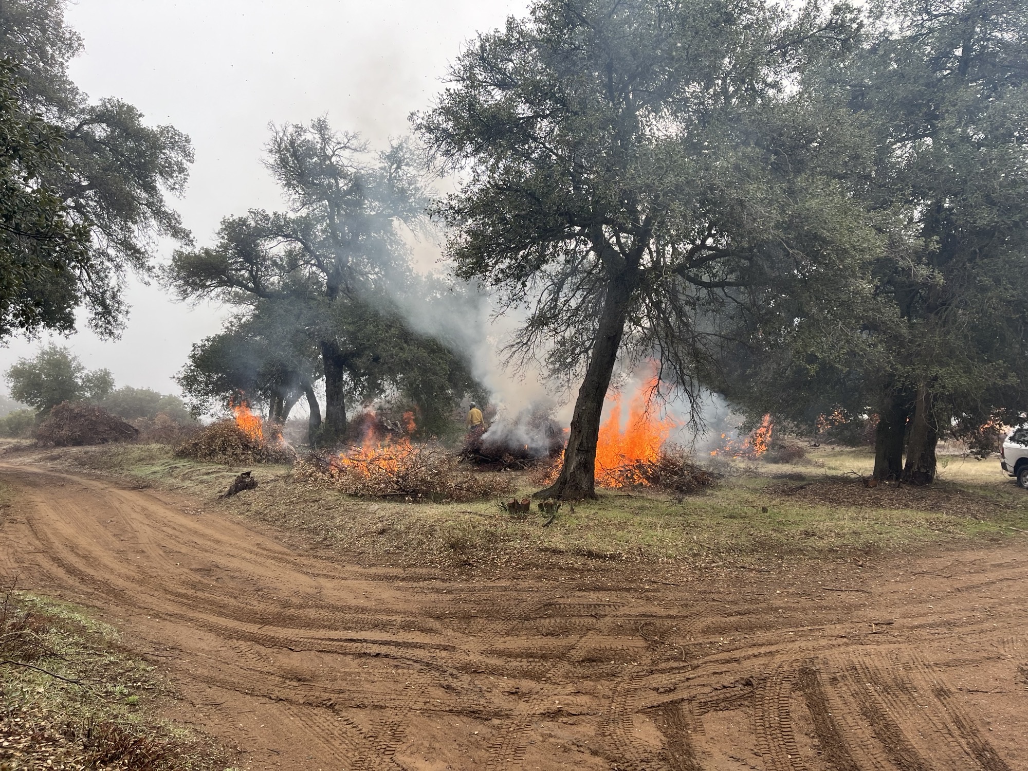
Tue, 02/20/2024 - 18:34
Image which shows dirt ground with tress in background. There are fuels on fire, and smoke on the Deer Creek Prescribed Burn.
Mount Laguna Prescribed Burn Descanso Ranger District Update 02 19 2024
Related Incident: 2025 - Cleveland National Forest, Forest Health Treatments
Publication Type: News
#MountLagunaRx
2/19/24 - Evening Update – Burn operations for the Mount Laguna Project in the Descanso Ranger District have been successfully completed. Firefighters achieved 2 acres successfully of their objective. Smoke may persist through the night.
Additional photos of this work and other fuel works on the Cleveland National Forest can be seen here.
#PrescribedBurn#PrescribedFire#ForestHealth#wildfirecrisis
Mount Laguna Prescribed Burn - Descanso Ranger District - 2-19-2024
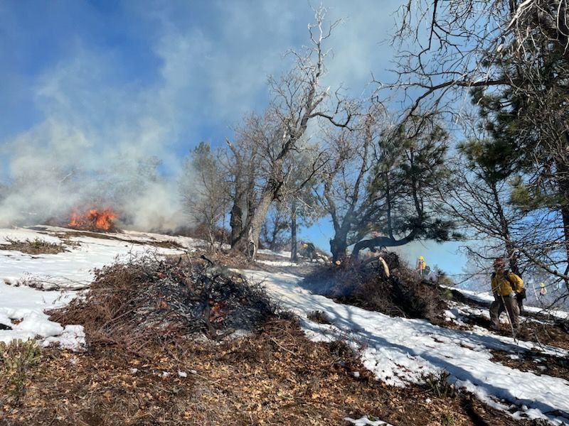
Mon, 02/19/2024 - 21:48
Image of snow ont he ground with fire, smoke, and firefighters working on the Mount Laguna Prescribed burn.