
Yuba River Ranger District Trapper Project Pileburn02 06 2024
Related Incident:
Publication Type: Announcement
Yuba River Ranger District resources are continuing prescribed fire operations on the Trapper project through Feb. 7, 2024. Smoke will be visible from Pike, Forest City, Camptonville and surrounding areas. Smoke impacts should be minimal.
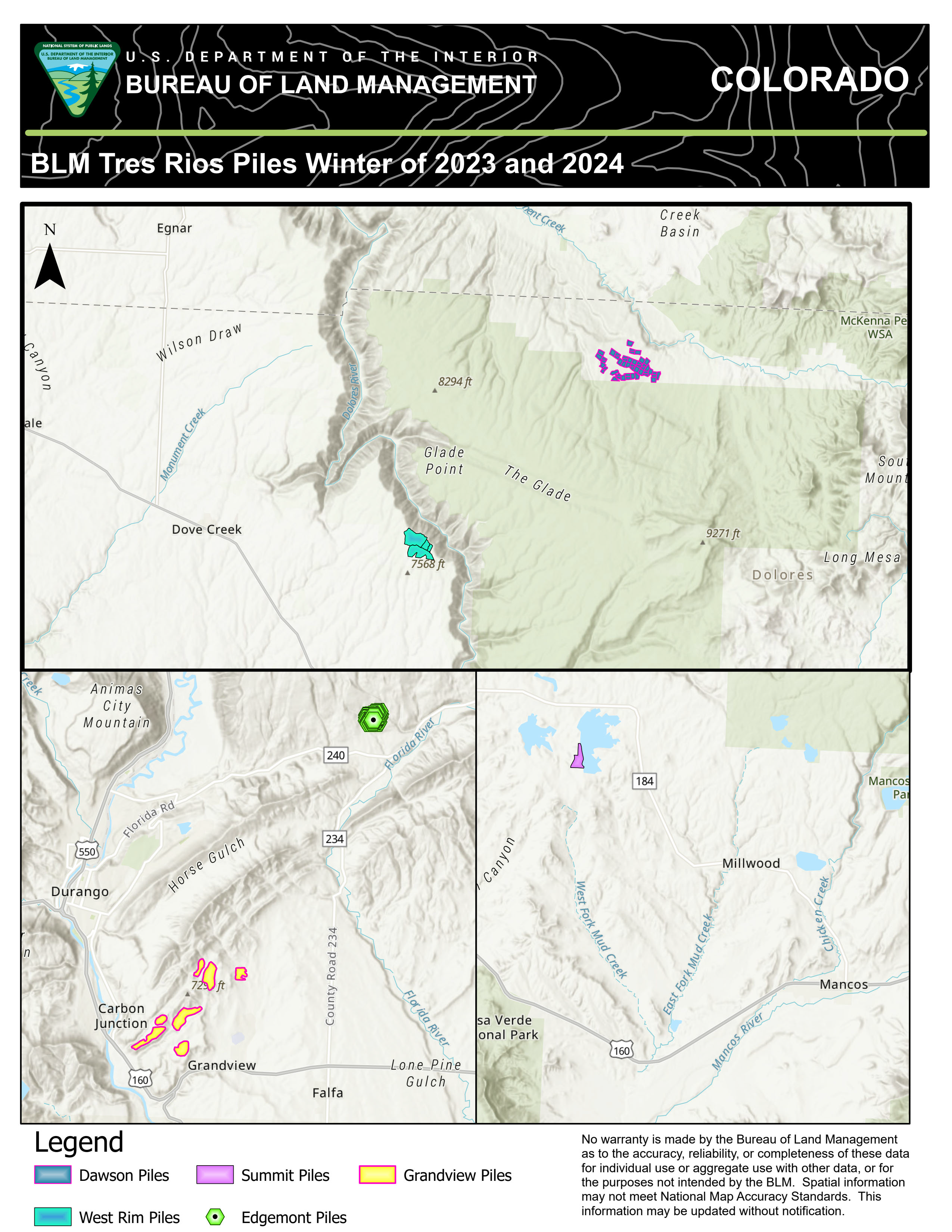
Grandview pile burning will resume on February 6th & 7th, 02 05 2024
Related Incident:
Publication Type: Announcement
Weather conditions are looking good for firefighters to resume pile burning at Grandview on February 6th and 7th. Grandview is located southeast of downtown Durango, CO on BLM managed lands. Smoke will be visible from Durango and Highways 160/550. If weather and clearing index are within the smoke permit parameters, then firefighters will initiate burning. Piles are composed of Pinyon and Juniper slash from a big game habitat improvement project and a hazardous fuels reduction project.
The project area has a detailed burn plan for prescribed burning that contains specific criteria regarding weather conditions and air quality that must be met to ensure control of the burn, as well as minimizing the potential smoke impact to local communities.
Expect visible smoke in the area on burn days, and lighter amounts for several days as vegetation in the interior continue to smolder. Rain and snow are forecasted this week.
For more information on smoke, visit https://www.colorado.gov/pacific/cdphe/wood-smoke-and-health
For information on prescribed burns, visit the Southwest District BLM Prescribed Fire InciWeb page https://inciweb.nwcg.gov/incident/7852/ or follow us on Twitter https://twitter.com/SWD_Fire and Facebook http://www.facebook.com/BLMMontroseFireUnit
Pine Valley Fuel Break - Descanso Ranger District 02 05 2024
Related Incident: 2025 - Cleveland National Forest, Forest Health Treatments
Publication Type: News
2/5/24 - CNF Descanso Ranger District fuel crews are burning piles off Deer Park Rd at Pine Creek Rd today as weather and environmental conditions allow. Residents and visitors may see smoke from Sunrise Hwy, the 79 and surrounding communities. PLEASE DO NOT REPORT.
Prescribed Fires such as pile burns are part of Confronting the Wildfire Crisis: https://fs.usda.gov/managing-land/wildfire-crisis. Prescribed fire plays an important role in forest health and in reducing extreme wildfires and their negative impact. These fires also help reduce heavy fuel loads while simultaneously opening the conifer forest structure and maintaining the health of meadow habitats. Fire is also used to enhance native plant communities and cultural landscapes and improve wildlife habitats. Another goal is to provide defensible space for communities and developed areas within and surrounding the CNF. With all fire comes smoke, and the U.S. Forest Service works to mitigate smoke impacts from prescribed fires on the communities in the area.
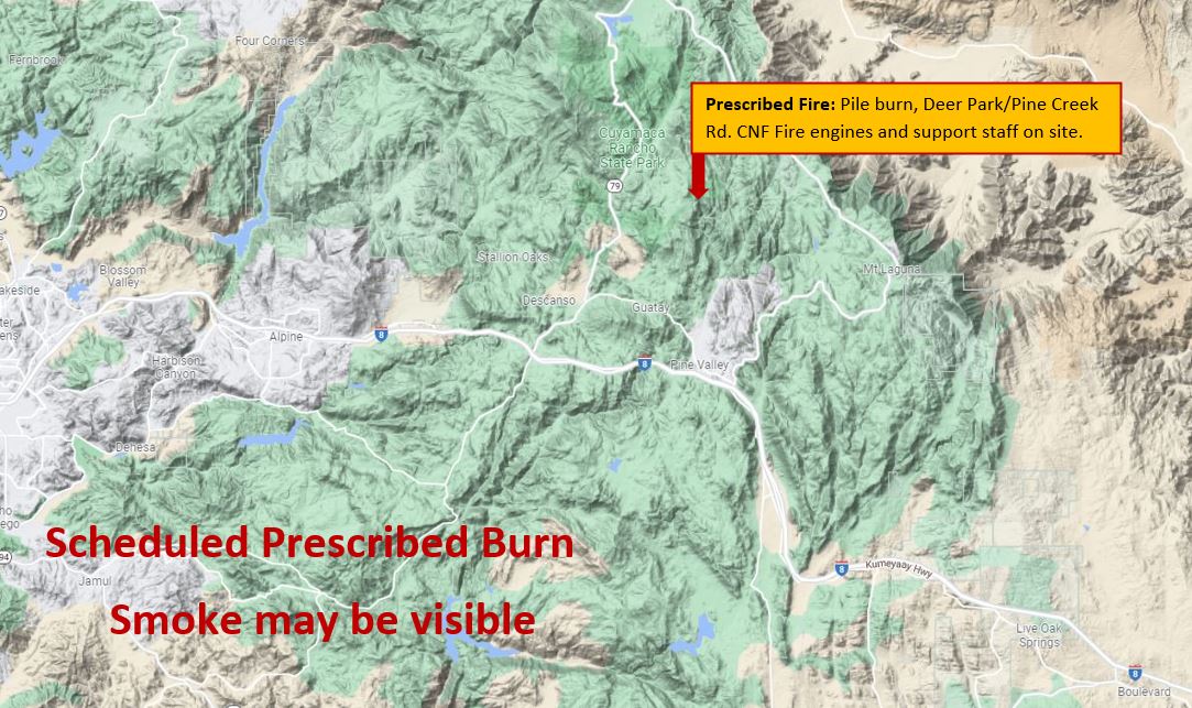
Map showing where the prescribed fire is burning.
North Main Broadcast Burn Trabuco Ranger District Update 02 03 2024
Related Incident: 2025 - Cleveland National Forest, Forest Health Treatments
Publication Type: News
#NorthMainRx
02/03/24 – The Trabuco Ranger District successfully executed a broadcast burn on 78 acres along the North Main Divide Fuel Break last week. We extend our heartfelt gratitude to our valued partners, including Orange County Fire Authority, Riverside County Fire (Cal Fire), Anaheim City Fire, Ontario City Fire, Newport Beach Fire, Murieta City Fire, Angeles National Forest, and the Los Padres National Forest, for their unwavering support and dedicated efforts in making this fire operation a success.
Presented below is a photograph capturing the diligent efforts of all participating units. Please go here to see more photographs from this broadcast burn.
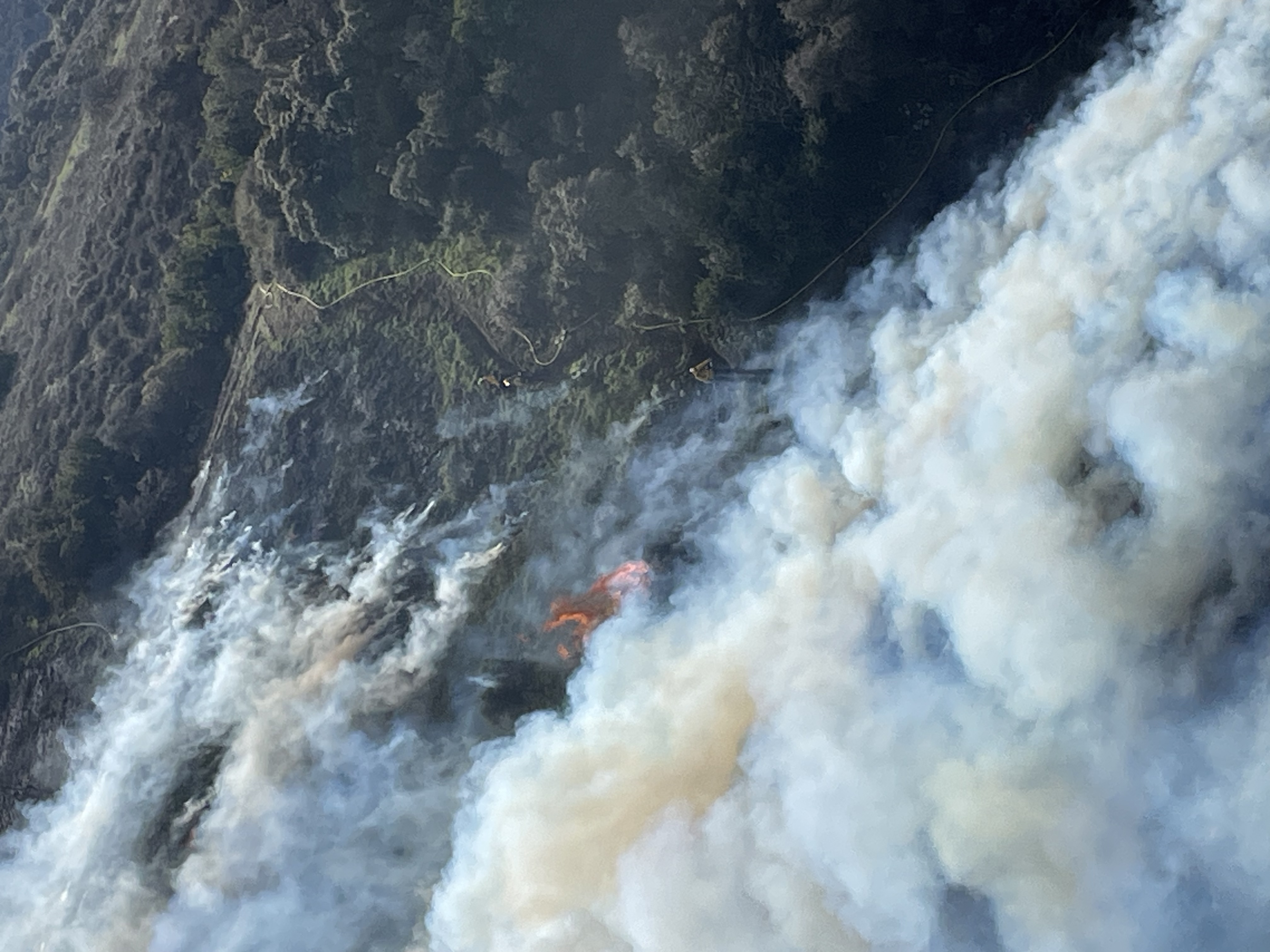
Ariel View of the North Main Broadcast Burn from January 20th through February 1st.
Jeff Valley RX Palomar Ranger District 02 03 2024
Related Incident: 2025 - Cleveland National Forest, Forest Health Treatments
Publication Type: News
2/3/24 - The Cleveland National Forest (CNF) Palomar Ranger District will be conducting a prescribed burn on the Jeff Valley Project. There is approximately 8 acres planned. Residents and visitors will see smoke visible throughout the week in the areas of Palomar Mountain, Hwy 79, Hwy 76, and surrounding communities. Please DO NOT REPORT.
Prescribed Fire is part of Confronting the Wildfire Crisis: https://fs.usda.gov/managing-land/wildfire-crisis. Prescribed fire plays an important role in forest health and in reducing extreme wildfires and their negative impact. These fires also help reduce heavy fuel loads while simultaneously opening the conifer forest structure and maintaining the health of meadow habitats. Fire is also used to enhance native plant communities and cultural landscapes and improve wildlife habitats. Another goal is to provide defensible space for communities and developed areas within and surrounding the CNF. With all fire comes smoke, and the U.S. Forest Service works to mitigate smoke impacts from prescribed fires on the communities in the area.
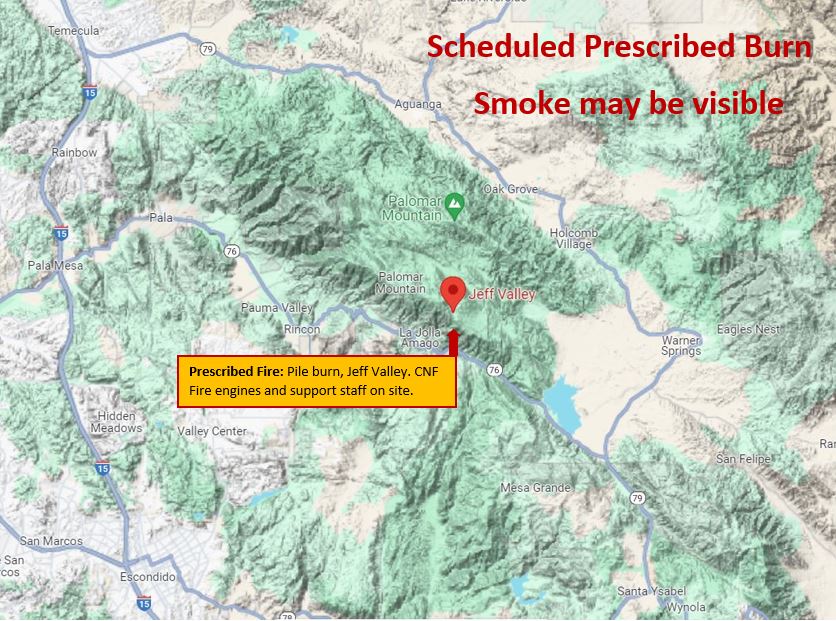
Map showing area of the Jeff Valley Prescribed burn.
Firefighters complete pile burning at Grandview and West Dolores Rim today 02 01 2024
Related Incident:
Publication Type: Announcement
Conditions were good for firefighters to complete 100 acres of pile burning at Grandview and another 100 acres of piles at West Dolores Rim on BLM Tres Rios Field Office managed lands. There are no plans to burn the rest of the week at Grandview near Durango, CO. Firefighters completed the winter pile burning at West Dolores Rim today.
Expect visible smoke throughout today, and lighter amounts for several days as vegetation in the interior continue to smolder. Rain and snow are forecasted for tonight and tomorrow in the areas.
For more information on smoke, visit https://www.colorado.gov/pacific/cdphe/wood-smoke-and-health
For information on prescribed burns, visit the Southwest District BLM Prescribed Fire InciWeb page https://inciweb.nwcg.gov/incident/7852/ or follow us on Twitter https://twitter.com/SWD_Fire and Facebook http://www.facebook.com/BLMMontroseFireUnit
Crews Finish Ignitions 02 01 2024
Related Incident: Rio Trampas Project Pile Burning
Publication Type: News
Fire crews have completed ignitions on the Rio Trampas Project piles for the winter season.
Piles from of approximately 180 out of 200 acres were treated with prescribed fire. The remaining piles, representing 20 acres of thinning, have a high fuel moisture content currently not conducive to burning down.
- Pile Unit off Forest Road 714 (100 acres): Completed
- Pile Unit west of Highway 76 (60 acres): Completed
- Pile Unit off Forest Road 207 (40 acres): Partially completed (approximately 20 acres remain)
The remaining piles will be addressed at a future time.
Crews will continue to patrol and monitor burned piles until the fire is called out.
Crews Moving to Piles off Forest Road 207, 02 01 2024
Related Incident: Rio Trampas Project Pile Burning
Publication Type: News
After quickly finishing the 60 acres of piles west of Highway 76 this morning, crews are moving to address the 40 acres of piles off Forest Road 207, east of Highway 76 and toward El Valle, NM.
Ignitions Continuing Today 02 01 2024
Related Incident: Rio Trampas Project Pile Burning
Publication Type: News
Fire crews are back for more pile burning, this time on a 60-acre unit on the west side of Highway 76 between Ojo Sarco and Trampas. Smoke is visible.
Crews Complete 100 Acres, Plan for More Ignitions Thursday01 31 2024
Related Incident: Rio Trampas Project Pile Burning
Publication Type: News
Fire crews finished burning piles made from 100 acres of thinning off Forest Road 714, between El Valle and Trampas. Crew members will turn their focus to monitoring and patrolling this area as piles continue to smolder.
On Thursday, crews plan to pile burn a 60-acre unit west of Highway 76 and between Ojo Sarco and Trampas.