
Palomar Ranger District Fuel Treatment Update Week of 01 29 2024
Related Incident: 2025 - Cleveland National Forest, Forest Health Treatments
Publication Type: News
1/29/24 - The Cleveland National Forest (CNF) Palomar Ranger District (PRD) is set to initiate prescribed fire preparation on the following projects:
Prescribed Fire Preparation:
North Ramona Fuelbreak (map 2) Urban Corp crews continue working on North Ramona West cut/pile work in the crosshatch area.
Fry Creek (map 3) – Crews may be working on handline improvements and/or snagging.
Jeff Valley (maps 4-6) – Crews may be working on handlines and various burn prep activities.
Palomar Fuelbreaks (map 7) – Crews may be working on various preparations for burning.
Prescribed Fire:
North Ramona Fuelbreak – prescribed burning may occur in all sections of N. Ramona FB (maps 1 & 2) with available burn windows – best opportunity this week may be on Thursday, Feb. 1.
Crews may initiate pile burning on various portions of the fuelbreak, depending on weather, resources availability, and access. Some portions of the fuelbreak will need to be burned under wet/moist conditions, other areas may be burned on days where we need simple/quick access for ignitions and mop-up.
Acres burned to date: 62 acres.
Palomar Mt. Piles – prescribed burning may occur in Jeff Valley or Fry Creek with available burn windows – planning to set up a pile burn Jeff Valley Units 11/12 (24 acres) on Wed., Jan. 31. Burning could go multiple days with the right conditions.
Our priority burn area in Jeff Valley (140 acres) will be in piles adjacent to Conifer Rd. (Units 11, 12, 9, 4, 6, and 18).
Our priority burn area in Fry Creek is Units 8a/b & 2a/b. We will likely burn in Jeff Valley as the priority over Fry Creek, but it is possible that we could burn piles in Fry Creek once we have snow on the ground.
Acres burned in Jeff Valley to date: 27 acres.
Palomar Fuelbreaks – prescribed burning may occur with available burn windows – planning to set up a broadcast burn Aguanga Unit 1 (61 acres) on Wed., Jan. 31.
Admin/Station Piles – pile burning could occur anytime conditions are favorable.
Prescribed Fire is part of Confronting the Wildfire Crisis: https://fs.usda.gov/managing-land/wildfire-crisis. Prescribed fire plays an important role in forest health and in reducing extreme wildfires and their negative impact. These fires also help reduce heavy fuel loads while simultaneously opening the conifer forest structure and maintaining the health of meadow habitats. Fire is also used to enhance native plant communities and cultural landscapes and improve wildlife habitats. Another goal is to provide defensible space for communities and developed areas within and surrounding the ENF. With all fire comes smoke, and the U.S. Forest Service works to mitigate smoke impacts from prescribed fires on the communities in the area.
#PrescribedBurn #PrescribedFire #ForestHealth #wildifrecrisis
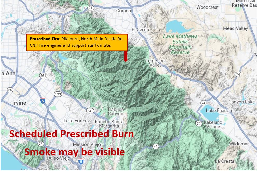
North Main Broadcast Burn Trabuco Ranger District Morning Update 01 30 2024
Related Incident: 2025 - Cleveland National Forest, Forest Health Treatments
Publication Type: News
#NorthMainRx
1/30/24 - The Cleveland National Forest (CNF) Trabuco Ranger District will be conducting a broadcast burn this week in several units on the North Main Project from January 30th through February 2nd from 9:00am to 5:00pm as weather and environmental conditions allow. There are approximately 190bacres planned during this broadcast burn. Residents and visitors will see smoke throughout the week in the areas of 241, I-5, I-15, Eagle Canyon Rd, Bedford Ridge Rd, North Main Divide Rd, and surrounding communities. Please DO NOT REPORT.
Broadcast burning is a type of prescribed fire that is ignited in areas with little or no forest canopy present, such as grasslands, shrublands, and oak woodlands. This type of fire burning is often used for habitat restoration and fuel reduction.
Broadcast burning can be beneficial for protecting and enhancing sage grouse habitat and mule deer and elk winter ranges by removing invasive species and promoting the growth of native vegetation. It can also help to reduce the risk of severe wildfires by reducing the buildup of forest fuels and improving the health and resilience of the ecosystem.
During broadcast burning, fire is spread across the landscape in a controlled manner, typically using specialized equipment such as drip torches or aerial ignition devices. The fires are closely monitored to ensure that they remain within the designated area and do not spread beyond control.
Prescribed Fires such as broadcast burn are part of Confronting the Wildfire Crisis: https://fs.usda.gov/managing-land/wildfire-crisis. Prescribed fire plays an important role in forest health and in reducing extreme wildfires and their negative impact. These fires also help reduce heavy fuel loads while simultaneously opening the conifer forest structure and maintaining the health of meadow habitats. Fire is also used to enhance native plant communities and cultural landscapes and improve wildlife habitats. Another goal is to provide defensible space for communities and developed areas within and surrounding the CNF. With all fire comes smoke, and the U.S. Forest Service works to mitigate smoke impacts from prescribed fires on the communities in the area.
For more information regarding the CNF 2024 Fuel Treatment Projects please go to: https://inciweb.nwcg.gov/incident-information/cacnf-20232024-cleveland-national-forest-fuel-treatments
#PrescribedBurn #PrescribedFire #ForestHealth #wildifrecrisis
North Main Broadcast Burn - Trabuco Ranger District - Map
Tue, 01/30/2024 - 13:28
Map showing area of the broadcast burn.
Ignitions Tentatively to Begin Wednesday, Jan. 3101 30 2024
Related Incident: Rio Trampas Project Pile Burning
Publication Type: News
With snow on the ground and more forecasted later this week, fire crews are preparing to potentially begin pile burning near the High Road to Taos (Highway 76) as early as Wednesday, Jan. 31. Forest Service personnel will be supported by partners, including the Ojo Sarco Volunteer Fire Department, Taos County, Red River Fire Department and the collaborative All Hands, All Lands Burn Team.
The piles are located in three locations adjacent to the communities of El Valle, Trampas and Ojo Sarco (see map). They were created from 200 acres of thinning as part of the Rio Trampas Project, which aims to restore forest health and resiliency next to communities while providing fuelwood and other wood product opportunities to residents and visitors.
The ponderosa forests around the communities are fire-dependent and must undergo fire disturbance on a regular basis to maintain resiliency. Discussions and collaboratives about improving the Embudo Creek Watershed, where these piles are located, have been occurring for years. Most recently, the Tres Rios Watershed Coalition was formed to identify priority areas for restoration.
"We're excited that the Carson National Forest and its partners are seeing these projects through to completion,” said Tres Rios Watershed Coalition Coordinator J.R. Logan. “Burning these piles under the right conditions is the best way to ensure that we've removed hazardous fuels in order to protect communities and improve the resiliency of these forests."
The project is part of the national Wildfire Crisis Strategy. As an area with some of the most at-risk firesheds in the nation, the strategy identified a 1.5-million-acre area in and around the Carson National Forest as the Enchanted Circle Landscape. Forest Service staff and partners across the region are working to protect communities and natural resources by restoring healthy, resilient, fire-adapted forests using mechanical thinning and returning beneficial fire in these landscapes.
As such, one of the piling areas is the result of 40 acres thinned by residents participating in the Carson National Forest’s unique partnership focused Mayordomo Program. The program works with organizations to have local leñeros, or woodcutters, adopt one-acre blocks of the forest and thin trees under a prescription that will contribute to reducing hazardous fuels. The leñeros in this unit kept the thinned wood, piled unusable wood and received a $300 stipend upon completion. The Rio de las Trampas Unit off Forest Road 207 is in partnership with the Rio de Las Trampas Forest Council, Forest Stewards Guild and many other partners.
Thinning and piling in two other areas planned for ignitions was completed by multiple local contractors:
- West of Highway 76: 60 acres
- East of Highway 76 and off Forest Road 714: 100 acres.
The piles off Forest Road 714 are adjacent to the 2023 El Valle Fire burn area. The fire last September burned 525 acres, including piles from about 260 acres of thinning. The cause of the fire is under investigation.
“I’m looking forward to taking advantage of the weather to treat the remaining piles around the communities,” said Camino Real District Ranger Michael Lujan. “Partnerships have and will continue to be critical to everyone’s success in stewarding the forest through the wildfire crisis.”
Fire managers will continue to monitor forecasts and ground conditions before ignitions. If circumstances change, they will postpone for a later date. Once burned, crews will patrol and monitor the piles until they are called out.
Yuba River Ranger District Trapper Project Pileburn01 30 2024
Related Incident:
Publication Type: Announcement
Tahoe National Forest will begin a prescribed pileburn at the junction of Henness Pass Rd and Mountain House Rd. on the Yuba River Ranger District. Fire and fuels personnel plan to prescribed burn up to 180 acres starting today, Jan. 30 through tomorrow, Jan. 31, conditions permitting. Smoke impacts will be minimal, visible from Goodyears Bar, Forest City, Pike, Camptonville and surrounding area.
Settings - change map background and toggle additional layers
Filter - control incident types displayed on map.
Zoom to your location
Reset map zoom and position
Could not determine your location.
Show Legend
 Wildfire
 Prescribed Fire
 Burned Area
Response
Burned Area
Response Other
Other
Rio Trampas Project Pile Burning
Unit Information
Incident Contacts
Prescribed Fire Updates 01 29 2024
Related Incident: Mendocino NF Fall 2023/Spring 2024 RX Fire Projects
Publication Type: News
Firefighters are taking advantage of burn windows today and tomorrow ahead of moderate-heavy precipitation forecasted for Wednesday-Friday.
Today fire personnel on the Grindstone Ranger District are planning ignitions on approximately 196 acres of machine piles in the M5 Hazard Tree Abatement project and another 199 acres in the Mill Brushing project along Trough Ridge.
On the Upper Lake Ranger District, fire personnel are planning ignitions tomorrow on machine piles, located at Pine Mountain and M1 Road with potential to burn 100-150 acres.
Current Pile Burning Activity 01 29 2024
Related Incident: Arapaho and Roosevelt National Forests Pile Burning
Publication Type: Announcement
01/29/2024: Firefighters continue to monitor previously burned areas. Some smoke will remain visible.
ACTIVE AREAS:
In Boulder and Gilpin County:
- Forsythe Area
- 2 miles east of Nederland, north of Magnolia Road, adjacent to Front Range Trailhead and FS Trail 606 near the intersection of Magnolia Road and Lazy Z Road
- Approximately mile maker 4.5 of Magnolia Road, north and south of Magnolia Road off FS Road 321 and 302
- 1.5 miles northwest of Wondervu, west side of Gross Reservoir
- 2 miles southwest of Pinecliffe, east of South Beaver Road, La Chula Road, and Wedgwood Road
- Yankee Hill Area
- 1 mile north of Gilpin County School, at the end of FS Trail 732
- 2 miles west of Central City, west of the intersection of Bald Mountain Road and FS Road 273.2
In Larimer County:
- Glen Haven 3: adjacent to Glen Haven on both sides of CR43
- Thompson River 4: 6 miles east of Estes Park, along FSR122 (Pole Hill Road)
- Thompson River 5: 4 miles southeast of Estes Park, at the intersection of US36 and FSR124
- Magic Sky 4: 5 miles southeast of Red Feather Lakes and north of CR74E near Red Feather Highlands/DU Mountain Campus
- Red Feather 5: 4 miles northeast of Red Feather Lakes, along CR67J (Prairie Divide Road)
- Devils Creek: 5 miles north of Crystal Lakes Subdivision; at the intersection of CR80C and FSR182
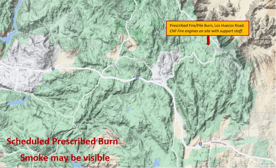
Mount Laguna Prescribed Burn Descanso Ranger District Afternoon Update 01 25 2024
Related Incident: 2025 - Cleveland National Forest, Forest Health Treatments
Publication Type: News
1/25/24 - Afternoon Update
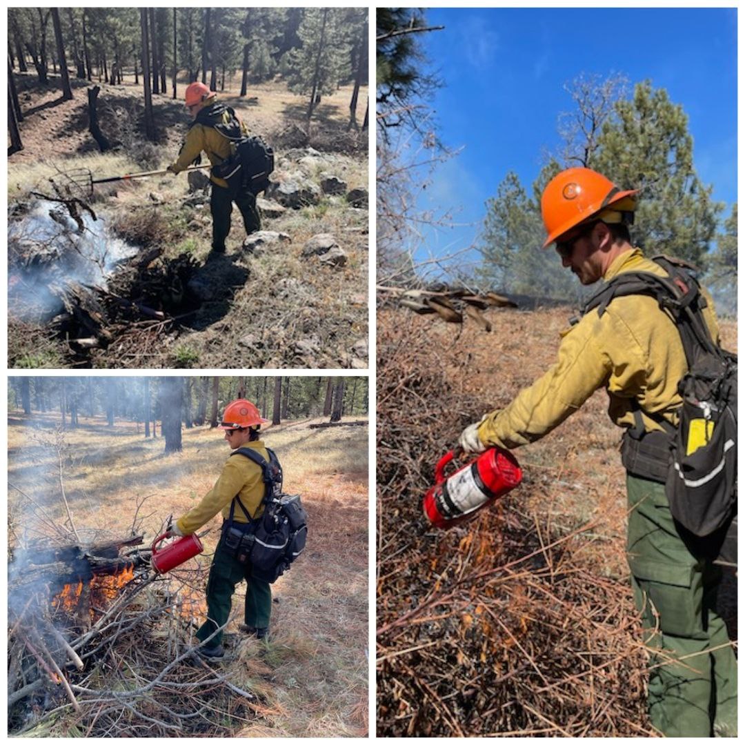
Crews have excelled under favorable weather conditions, garnering an exceptional response to the prescribed burn on Mount Laguna. Fire crew are playing a crucial role in enhancing forest health and mitigating the risk of severe wildfires and their adverse effects. The teams remain steadfast in their efforts to reduce substantial fuel loads, creating defensible space for communities and developed areas within and around the CNF. Their ongoing commitment ensures a proactive approach to wildfire prevention and community safety.
One of the crews working on maintaining the prescribed burn is the new Monument Peak Fuels Crew. Pictured below are crew members Diego Calderon, Dallas Dimino, and Jonas Casale.
Residents and visitors will continue to see flames and smoke visible throughout the day in the areas of Sunrise Highway, the I-8 and surrounding communities. Please DO NOT REPORT.
Monument Peak Fuels Crew Members
Thu, 01/25/2024 - 18:23
Some of the members crews working on maintaining the prescribed burn is the new Monument Peak Fuels Crew. Pictured below is Diego Calderon, Dallas Dimino, and Jonas Casale.
Mount Laguna Prescribed Burn Descanso Ranger District Morning Update 01 25 2024
Related Incident: 2025 - Cleveland National Forest, Forest Health Treatments
Publication Type: News
#MountLagunaRx
1/25/24 - The Cleveland National Forest (CNF) Descanso Ranger District will conduct a prescribed burn today in the Mount Laguna area from 9:00am to 5:00pm as weather and environmental conditions allow. Residents and visitors can expect to witness flames and smoke in the areas of Sunrise Highway, the I-8, and surrounding communities throughout the day. Please DO NOT REPORT.
Prescribed Fire is part of Confronting the Wildfire Crisis: https://www.fs.usda.gov/managing-land/wildfire-crisis.
Prescribed fire plays an important role in forest health and in reducing extreme wildfires and their negative impact. These fires also help reduce heavy fuel loads while simultaneously opening the conifer forest structure and maintaining the health of meadow habitats. Fire is also used to enhance native plant communities and cultural landscapes and improve wildlife habitats. Another goal is to provide defensible space for communities and developed areas within and surrounding the ENF. With all fire comes smoke, and the U.S. Forest Service works to mitigate smoke impacts from prescribed fires on the communities in the area.
#PrescribedBurn #PrescribedFire #ForestHealth #wildifrecrisis
Mount Laguna Prescribed Burn - Descanso Ranger District Map

Thu, 01/25/2024 - 13:07
Map showing where the Mount Laguna Prescribed Burn will occur.
Ignitions in Progress 01242024 01 24 2024
Related Incident:
Publication Type: News
Fire crews have begun ignitions. Smoke may be visble from the pile burning unit.