
Jan. 7, 2024 Firefighters at West Dolores Rim unit burn 175 acres of piles 01 07 2024
Related Incident:
Publication Type: Announcement
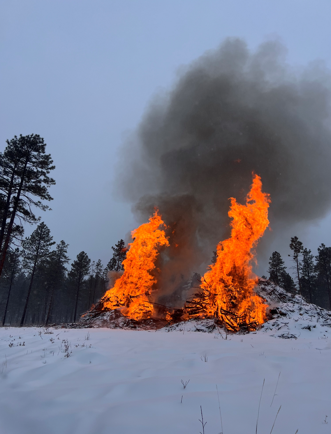
Snowy weather conditions gave firefighters the opportunity to burn 175 acres of piles from logging slash at the West Dolores Rim project area on Tres Rios Field Office BLM managed lands located southeast of Dolores, CO. There will be some residual smoke for a few days as piles smolder and burn out.
For more information on smoke, visit https://www.colorado.gov/pacific/cdphe/wood-smoke-and-health
For information on prescribed burns, visit the Southwest District BLM Prescribed Fire InciWeb page https://inciweb.nwcg.gov/incident/7852/ or follow us on Twitter https://twitter.com/SWD_Fire and Facebook http://www.facebook.com/BLMMontroseFireUnit
Lump Gulch Fire Update 01 07 2024
Related Incident:
Publication Type: News
BOULDER, Colo. (January 7, 2024) –
Containment: 50%
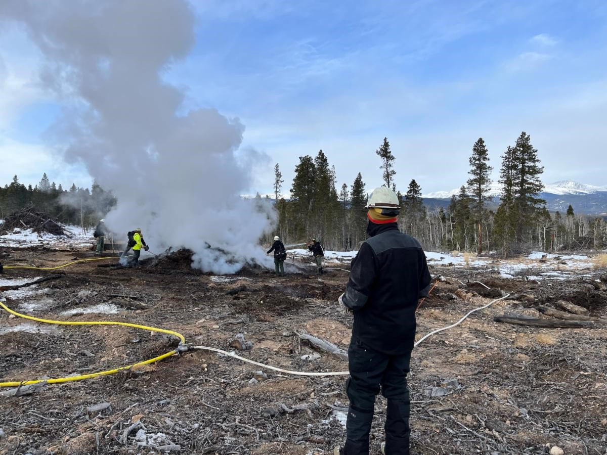
Today, crews are using a skid steer to open the pile and dump snow on it. Smoke dispersal is currently poor, and smoke will be visible along Highway 72 as they work the pile. 2-4 inches of snow is expected in the area today, which may assist with operations. Crews from The Nature Conservancy will be assisting today along with the Forest Service, Timberline, and Nederland. A water tender truck from Timberline will be standing by to assist as needed.
The U.S. Forest Service, Timberline Fire Protection District, and Nederland Fire Protection District responded to the Lump Gulch Fire at 4:30 p.m. on Saturday, January 6, 2024 after receiving reports of smoke in Gilpin County, Boulder Ranger District, near the intersection of Gilpin Road and Highway 119. Crews discovered a machine pile 60 feet by 60 feet burning in a landing on Forest Service land. Crews began suppressing the fire with water. The cause is currently unknown and under investigation.
The Lump Gulch Fire is not part of current pile burning operations in the area.
BLM Southwest District plan to prescribe burn piles at West Dolores Rim 01 06 2024
Related Incident:
Publication Type: News
If conditions allow the BLM Tres Rios Field Office plans to initiate prescribed pile burning in the West Dolores Rim project area on BLM-managed lands located approximately 10 miles southeast of Dove Creek, CO on January 7th and 8th, 2024.
The piles contain large logging slash that were created from previous mechanical treatments to reduce hazardous fuels. Firefighters plan to burn two to three piles per a day and will monitor them after completion to ensure public safety.
The project area has a detailed burn plan that outlines the parameters for prescribed burning and contains specific criteria regarding weather conditions and air quality that must be met to ensure control of the burn, as well as minimizing the potential smoke impact to local communities.
Expect columns of smoke in the area, due to the large piles burning. Most of the smoke will lift and dissipate during the warmest parts of the day. Smoke will be visible for several days after each burn is completed as vegetation in the interior continues to smolder.
For more information on smoke, visit https://www.colorado.gov/pacific/cdphe/wood-smoke-and-health.
For information on prescribed burns, visit the Southwest District BLM Prescribed Fire InciWeb page (https://inciweb.nwcg.gov/incident/7852/) or follow us on Twitter (https://twitter.com/SWD_Fire) and Facebook (http://www.facebook.com/BLMMontroseFireUnit).
BLM Southwest District plan to prescribe burn piles at West Dolores Rim January 7 8, 01 06 2024
Related Incident:
Publication Type: Announcement
If conditions allow the BLM Tres Rios Field Office plans to initiate prescribed pile burning in the West Dolores Rim project area on BLM-managed lands located approximately 10 miles southeast of Dove Creek, CO on January 7th and 8th, 2024.
The piles contain large logging slash that were created from previous mechanical treatments to reduce hazardous fuels. Firefighters plan to burn two to three piles per a day and will monitor them after completion to ensure public safety.
The project area has a detailed burn plan that outlines the parameters for prescribed burning and contains specific criteria regarding weather conditions and air quality that must be met to ensure control of the burn, as well as minimizing the potential smoke impact to local communities.
Expect columns of smoke in the area, due to the large piles burning. Most of the smoke will lift and dissipate during the warmest parts of the day. Smoke will be visible for several days after each burn is completed as vegetation in the interior continues to smolder.
For more information on smoke, visit https://www.colorado.gov/pacific/cdphe/wood-smoke-and-health.
For information on prescribed burns, visit the Southwest District BLM Prescribed Fire InciWeb page (https://inciweb.nwcg.gov/incident/7852/) or follow us on Twitter (https://twitter.com/SWD_Fire) and Facebook (http://www.facebook.com/BLMMontroseFireUnit).
Yuba River Ranger District Beartrap Unit F01 04 2024
Related Incident:
Publication Type: Announcement
Tahoe National Forest Yuba River Ranger District completed 10 acres of prescribed pileburning near the North San Juan Ridge today, Jan. 4, 2024. Units will remain on scene to monitor.
Truckee Ranger District Klondike Pileburn 12 19 2023
Related Incident:
Publication Type: Announcement
Tahoe National Forest Truckee Ranger District will be igniting 5 acres of hand piles West of Klondike today, Dec. 19, 2023. Smoke impacts will be minimal. Klondike flats may experience short term smoke impacts.
Sierraville Ranger District Independence Piles 12 18 2023
Related Incident:
Publication Type: Announcement
Tahoe National Forest Sierraville Ranger District plans to pileburn 70 acres near Independence Lake and Secret Meadows today, Dec. 18, 2023. Smoke will be visible from the Highway 89 corridor from Little Truckee Summit to Sagehen Summit. Smoke will possibly settle in valleys and the 89 corridor overnight.
Truckee Ranger District East Stampede Dam 12 14 2023
Related Incident:
Publication Type: Announcement
Tahoe National Forest, Truckee Ranger District fire personnel plan to ignite 7 acres of hand piles at East Stampede Dam and Stampede Station today. Smoke will be visible but impacts will be minimal.
Sierraville Ranger District Independence 12 14 2023
Related Incident:
Publication Type: Announcement
Tahoe National Forest, Sierraville Ranger District fire personnel plan to ignite 10 acres of grapple piles in the Independence Lake area. Smoke will be visible, but impacts will be minimal.
Truckee Ranger District East Stampede Dam 12 13 2023
Related Incident:
Publication Type: Announcement
Tahoe National Forest fire personnel will be igniting 9.5 acres of hand piles in the East Stampede area today, Dec. 13, 2023. Smoke may be visible from Truckee. Smoke impacts will be minimal and carefully monitored.