
Ignitions Continuing Today 02 01 2024
Related Incident: Rio Trampas Project Pile Burning
Publication Type: News
Fire crews are back for more pile burning, this time on a 60-acre unit on the west side of Highway 76 between Ojo Sarco and Trampas. Smoke is visible.
Crews Complete 100 Acres, Plan for More Ignitions Thursday01 31 2024
Related Incident: Rio Trampas Project Pile Burning
Publication Type: News
Fire crews finished burning piles made from 100 acres of thinning off Forest Road 714, between El Valle and Trampas. Crew members will turn their focus to monitoring and patrolling this area as piles continue to smolder.
On Thursday, crews plan to pile burn a 60-acre unit west of Highway 76 and between Ojo Sarco and Trampas.
BLM plans to burn piles at Grandview and West Dolores Rim on Feb. 1 and 2, 01 31 2024
Related Incident:
Publication Type: Announcement
BLM Tres Rios Field Office plans to initiate prescribed pile burning on BLM-managed lands in the Grandview and West Dolores Rim project areas on February 1st and 2nd, if all conditions allow.
Grandview piles are located approximately 2 miles southeast of downtown Durango, CO and 2 miles west of Mercy Hospital in La Plata County in the Grandview and 3 Springs area. Piles are composed of pinyon-juniper slash from a 247-acre big game habitat improvement and hazardous fuels reduction project. Smoke permit requirements, clearing index, and fire effects will determine if firefighters burn up to 2,000 piles in the area. Smoke will be visible south of Durango and from Highways 160 and 550, please do not report.
West Dolores Rim piles are located 6 miles east of Dove Creek, CO, and Highway 491in Dolores County. The project area covers 15 acres near the Dolores Canyon Overlook. Based on smoke permit requirements and clearing index; firefighters plan to burn approximately 20 piles of ponderosa pine slash from a hazardous fuel’s reduction project. Smoke may be visible from Dove Creek, CO, and Highway 491.
The project areas have detailed burn plans that outline the parameters for prescribed burning and contain specific criteria regarding weather conditions and air quality that must be met to ensure control of the burn, as well as minimizing the potential smoke impact to local communities.
While smoke may be visible in the area at times, most of the smoke will lift and dissipate during the warmest parts of the day. Expect visible smoke in the areas for several days after each burn is completed as vegetation in the interior continues to smolder.
For more information on smoke, visit https://www.colorado.gov/pacific/cdphe/wood-smoke-and-health.
For information on prescribed burns, visit the Southwest District BLM Prescribed Fire InciWeb page (https://inciweb.nwcg.gov/incident/7852/) or follow us on Twitter (https://twitter.com/SWD_Fire) and Facebook (http://www.facebook.com/BLMMontroseFireUnit).
Kitchen Creek Broadcast Burn Descanso Ranger District 01 31 2024
Related Incident: 2025 - Cleveland National Forest, Forest Health Treatments
Publication Type: News
1/31/24 - The Cleveland National Forest (CNF) Descanso Ranger District is conducting a 54-acre broadcast burn off Kitchen Creek Rd one mile south of Sunrise Hwy today as weather and environmental conditions allow. Residents and visitors may see smoke from Sunrise Hwy, the I-8 and surrounding communities. Please DO NOT REPORT. This Project is funded in part by a grant from the San Diego River Conservancy, supporting the Wildfire Crisis Strategy.
Broadcast burning is a type of prescribed fire that is ignited in areas with little or no forest canopy present, such as grasslands, shrublands, and oak woodlands. This type of fire burning is often used for habitat restoration and fuel reduction.
Broadcast burning can be beneficial for protecting and enhancing wildlife habitat and removing invasive species and promoting the growth of native vegetation. It can also help to reduce the risk of severe wildfires by reducing the buildup of forest fuels and improving the health and resilience of the ecosystem.
During broadcast burning, fire is spread across the landscape in a controlled manner, typically using specialized equipment such as drip torches or aerial ignition devices. The fires are closely monitored to ensure that they remain within the designated area and do not spread beyond control.
Prescribed Fires such as broadcast burn are part of Confronting the Wildfire Crisis: https://fs.usda.gov/managing-land/wildfire-crisis. Prescribed fire plays an important role in forest health and in reducing extreme wildfires and their negative impact. These fires also help reduce heavy fuel loads while simultaneously opening the conifer forest structure and maintaining the health of meadow habitats. Fire is also used to enhance native plant communities and cultural landscapes and improve wildlife habitats. Another goal is to provide defensible space for communities and developed areas within and surrounding the CNF. With all fire comes smoke, and the U.S. Forest Service works to mitigate smoke impacts from prescribed fires on the communities in the area.
For more information regarding the CNF 2024 Fuel Treatment Projects please go to: https://inciweb.nwcg.gov/.../cacnf-20232024-cleveland...
#PrescribedBurn #PrescribedFire #ForestHealth #wildifrecrisis
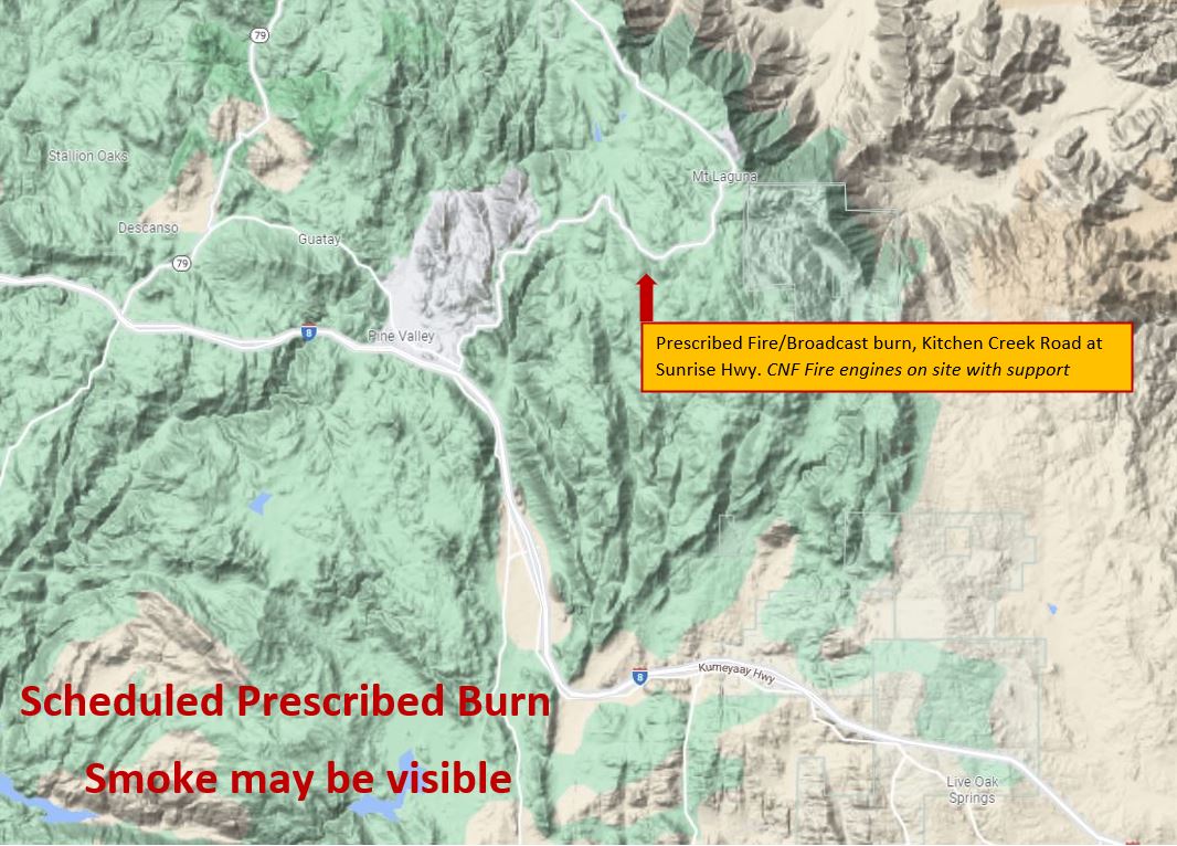
Map of area of broadcast burn for the Kitchen Creek R[rescribed fire.
North Main Broadcast Burn Trabuco Ranger District 01 31 2024
Related Incident: 2025 - Cleveland National Forest, Forest Health Treatments
Publication Type: News
#NorthMainRx
1/31/24 - The Cleveland National Forest (CNF) Trabuco Ranger District will be conducting a broadcast burn this week in several units on the North Main Project from January 30th through February 2nd from 9:00am to 5:00pm as weather and environmental conditions allow. There are approximately 190 acres planned during this broadcast burn. Residents and visitors will see smoke throughout the week in the areas of 241, I-5, I-15, Eagle Canyon Rd, Bedford Ridge Rd, North Main Divide Rd, and surrounding communities. Please DO NOT REPORT.
Broadcast burning is a type of prescribed fire that is ignited in areas with little or no forest canopy present, such as grasslands, shrublands, and oak woodlands. This type of fire burning is often used for habitat restoration and fuel reduction.
Broadcast burning can be beneficial for protecting and enhancing sage grouse habitat and mule deer and elk winter ranges by removing invasive species and promoting the growth of native vegetation. It can also help to reduce the risk of severe wildfires by reducing the buildup of forest fuels and improving the health and resilience of the ecosystem.
During broadcast burning, fire is spread across the landscape in a controlled manner, typically using specialized equipment such as drip torches or aerial ignition devices. The fires are closely monitored to ensure that they remain within the designated area and do not spread beyond control.
Prescribed Fires such as broadcast burn are part of Confronting the Wildfire Crisis: https://fs.usda.gov/managing-land/wildfire-crisis. Prescribed fire plays an important role in forest health and in reducing extreme wildfires and their negative impact. These fires also help reduce heavy fuel loads while simultaneously opening the conifer forest structure and maintaining the health of meadow habitats. Fire is also used to enhance native plant communities and cultural landscapes and improve wildlife habitats. Another goal is to provide defensible space for communities and developed areas within and surrounding the CNF. With all fire comes smoke, and the U.S. Forest Service works to mitigate smoke impacts from prescribed fires on the communities in the area.
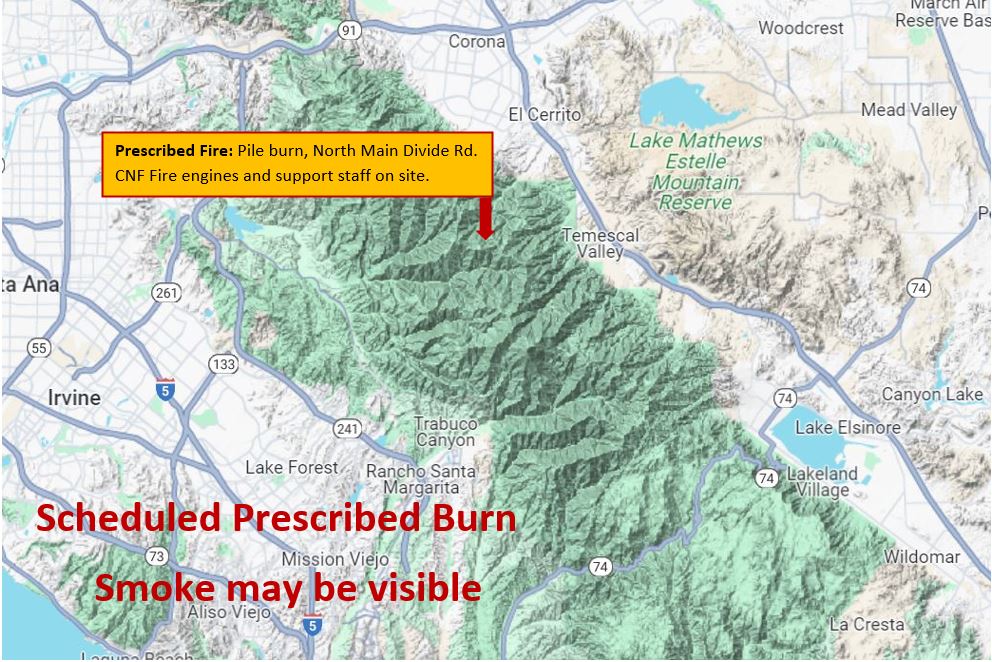
Map showing area of the broadcast burn.
#PrescribedBurn #PrescribedFire #ForestHealth #wildifrecrisis
Ignitions Begin01 31 2024
Related Incident: Rio Trampas Project Pile Burning
Publication Type: News
After conducting a test fire, fire crews began ignitions on the 100-acre unit off Forest Road 714 between El Valle and Trampas at approximately 10:45 a.m.
Smoke is visible in the area.
Current Pile Burning Activity 02 13 2024
Related Incident: Arapaho and Roosevelt National Forests Pile Burning
Publication Type: Announcement
Active ignitions, smoke may be visible throughout the week -
- Larimer County
- Boulder and Gilpin County:
- Forsythe Area - Rollinsville, S Beaver Rd, Lazy Z, Coal Creek Canyon, and Nederland should expect some smoke impacts through the evening of 2/9/24 as the piles burn down.
- Yankee Hill Area
-----
Possible ignition locations for the week of 2/12/24, depending on conditions:
- Boulder and Gilpin County:
- Forsythe Area (1.5 miles northwest of Wondervu, west side of Gross Reservoir)
- Yankee Hill Area (1 mile north of Gilpin County School, at the end of FS Trail 732)
- Larimer County:
Yuba River Ranger District Bear Trap Unit B Pileburn01 30 2024
Related Incident:
Publication Type: Announcement
Tahoe National Forest's Yuba River Ranger District plans to prescribed burn 5 acres of piles on the North San Juan Ridge off Tyler Foote Crossing Road near Grizzly Creek, tomorrow, January 31, 2024.
American River Ranger District Mosquito Fire Grapple Piles 01 30 2024
Related Incident:
Publication Type: Announcement
Tahoe National Forest's American River Ranger district plans to prescribed burn 4 acres of grapple piles on Sugar Pine Road today, Jan. 30, 2024. Smoke may be visible in the area.
Current Pile Burning Activity 01 30 2024
Related Incident: Arapaho and Roosevelt National Forests Pile Burning
Publication Type: Announcement
01/30/2024: Firefighters continue to monitor and patrol active areas. Some smoke will remain visible.
ACTIVE AREAS:
In Boulder and Gilpin County:
- Forsythe Area
- 2 miles east of Nederland, near the intersection of Magnolia Road and Lazy Z Road
- 1.5 miles northwest of Wondervu, west side of Gross Reservoir
- 2 miles southwest of Pinecliffe, east of South Beaver Road, La Chula Road, and Wedgwood Road
- Yankee Hill Area
- 1 mile north of Gilpin County School, at the end of FS Trail 732
- 2 miles west of Central City, west of the intersection of Bald Mountain Road and FS Road 273.2
In Larimer County:
- Glen Haven 3: adjacent to Glen Haven on both sides of CR43
- Thompson River 4: 6 miles east of Estes Park, along FSR122 (Pole Hill Road)
- Thompson River 5: 4 miles southeast of Estes Park, at the intersection of US36 and FSR124
- Magic Sky 4: 5 miles southeast of Red Feather Lakes and north of CR74E near Red Feather Highlands/DU Mountain Campus
- Red Feather 5: 4 miles northeast of Red Feather Lakes, along CR67J (Prairie Divide Road)
- Devils Creek: 5 miles north of Crystal Lakes Subdivision; at the intersection of CR80C and FSR182