
Smokehouse Creek Fire Update 02 28 2024
Related Incident:
Publication Type: Announcement
Smokehouse Creek fire updates
February 27th, 9:00pm
Size: 250,000 acres
Containment: 0%
Cause: Under investigation
The Smokehouse Creek Fire has spread across multiple counties and multiple spot fires are spreading. Personnel on the fire are continuously planning and adapting to the circumstances. Safety continues to be the top priority for the ongoing operation, for both residents and working personnel. Several crews are working in Canada, TX, and have placed a control line around the town. More equipment is en route to the town of Miami.
High winds, high temperatures, and low humidities all day have caused extreme fire behavior to occur and a rapid rate of spread. Winds were predominantly out of the east until a frontal passage came through causing winds to shift to out of the north. Winds are expected to continue into the night and tomorrow. Fire behavior has shown long-range spotting and high rates of spread.
As of 9:00 February 27th, shelter-in-place is in effect for Canadian.
There are current highway closures that will continue to change as the fire progresses. Highway 83 is closed in Hemphill County going in both directions. Highways 83 and 23 in Lipscomb County are also closed.
Windy Deuce Fire Update 02 28 2024
Related Incident:
Publication Type: Announcement
Size: 20,000
Containment: 20%
Start Date: Monday, February 26, 2024
Cause: Under Investigation
The Windy Deuce fire is currently burning in Hutchinson County. Texas A&M Forest Service is currently working in unified command with the city of Fritch, Hutchinson County, and National Park Service. Crews are working to protect public lives, properties, and slow fire spread in high wind conditions.
Yesterday: Crews worked overnight to construct containment lines around the fire and slow the fire growth towards the town of Fritch. Engines and heavy equipment from Texas A&M Forest Service, National Park Service, and Hutchinson County worked to construct lines, put out active flames and prepare areas in expectation of high winds today.
Today: Crews continue to battle high winds and are working diligently to slow fire progression and protect the town of Fritch. The fire did enter into the south side of the town and crews are working to protect structures along and south of highway 136. Additional engines are enroute to assist with protecting structures and suppressing this fire. The fire moved south of Fritch and progressed eastward towards the town of Borger.
Heavy Equipment resources are working along the southern flank of the fire to construct lines and prevent the further spread to the south of the fire in anticipation of an oncoming front and winds out of the north. Firefighters will be on scene throughout the night, constructing lines and patrolling around structures to quickly respond to any fires. All fire resources in the area are focused on protecting lives, structures, and properties.
Weather and Fire Behavior: High winds, high temperatures, and low humidities all day have caused extreme fire behavior to occur and a rapid rate of spread. Winds were predominantly out of the east until a frontal passage came through causing winds to shift to out of the north. Winds are expected to continue into the night and tomorrow. Fire behavior has shown long range spotting and high rates of spread.
Evacuations: In the town of Fritch, the following neighborhoods have been evacuated: Double Diamond, Arrowhead Addition, Maverick, Alibates, McBride, Mullinaw, Harbory Bay, Chisolm Trail, Arroyo Grande, and Sage Brush. The City of Borger has opened two shelter locations: Church of Christ and Fairlands Baptist Church. In the City of Fritch, there is a shelter open at Celebration Family Church.
Damages/Injuries: Structures have been confirmed lost at this time. This is an evolving situation and due to the complexity of the fire, there are no details on the number and type of structures that have been destroyed/damaged at this time. There are no reported injuries at this time.
Closures: Highway 136 is closed on both sides of Fritch and 207 northbound from Panhandle is closed.
Windy Deuce fire update, 4:40 pm, 02 27 2024
Related Incident:
Publication Type: News
Windy Deuce Fire updates
February 27th, 4:40 pm
Size: 8,000
Containment: 20%
Cause: Under investigation
The Windy Deuce Fire is extreme. Crews on site are continuing work to reduce damage. Safety continues to be the top priority for the ongoing operation, for both residents and working personnel. Incoming winds will be strong and gusty. The town of Fritch,Tx is being heavily impacted by the fire, and residents are required to evacuate immediately. The neighboring town of Borger has two locations for evacuees, Church of Christ and Fairlands Baptist Church. Both the north and south routes of HW 136 are closed, and evacuees should go north towards Sanford.
As of February 27th at 12:55 pm, evacuations were ordered for Double Diamond, Alibates, McBride, Mullinaw, Harbor Bay and then expanded hours later for the entirety of Fritch.
Evacuation Shelter: City of Borger has two locations for evacuees, Church of Christ and Fairlands Bastist Church
Road closure: HIGHWAY 136 is closed on both sides of Fritch, TX. Please evacuate north towards Sanford.
Smokehouse Creek Fire Update, 3:00 p.m., 02 27 2024
Related Incident:
Publication Type: Announcement
Smokehouse Creek Fire Updates
February 27th, 3:00pm
Size: 200,000 acres
Containment: 0%
Fire is ongoing and subject to change rapidly due to strong wind. Crews are continuously planning and adapting to the circumstances. Several different agencies under unified command are route for structure protection in the town of Canadian.
A shelter-in-place is in effect for the towns in Canadian.
There are current highway closures that will continue to change as the fire progresses. Highway 83 is closed in Hemphill County going in both directions. Highway 83 and 23 in Lipscomb County are also closed.
Windy Deuce fire update, 3:00 p.m., 02 27 2024
Related Incident:
Publication Type: News
Windy Deuce fire updates
February 27th, 3:00pm
size: 8,000 acres
Containment: 20%
Cause: Unknown
Resources on site are continuing work to contain the Windy Deuce fire. Dozer crews are preparing for likely wind shifts along the south flank, while engines address hot spot areas. The fire has crossed the Canadian river , and the town of Fritch is at risk.
There are evacuations in order for the following communities:Double Diamond, Alibates, McBride, Mullinaw, Harbor Bay. All in the Fritch community.
There are current highway closures.Highway136 West-to Amarillo is being shutdown at this time due to heavy smoke, east bound remains open.
Smokehouse Creek Fire Evacuations, 12:45 p.m., 02 27 2024
Related Incident:
Publication Type: Announcement
Candian Area Closures, Feb. 27, 2024
12:45 p.m.
Evacuations are being put in place for areas of Canadian. Residents between South River Rd and Highway 83 N are to be evacuated along with residents of Glazier. Evacuees may go to the Higgins Elementary school for temporary shelter.
Windy Deuce Fire Evacuations, 12:00 p.m, 02 27 2024
Related Incident:
Publication Type: Announcement
Windy Deuce Fire area evacuations,
February 27, 2024
12:10 p.m.
Evacuation preparations are being put in place for the areas of Double Diamond, Arrowhead and Maverick Villages in the City of Fritch. Extreme winds have picked up fire activity and is now steering the fire in these directions.
Jeff Valley RX Palomar Ranger District 02 27 2024
Related Incident: 2025 - Cleveland National Forest, Forest Health Treatments
Publication Type: News
2/27/24 – The Cleveland National Forest Palomar Ranger district will be conducting a prescribed burn on the Jeff Valley fuel project, contingent on weather and environmental conditions. Residents and visitors will see smoke visible throughout the day in the areas of Palomar Mountain, Escondido, Pala, Valley Center, and surrounding communities. Please DO NOT REPORT.
California Climate Investment grant and the Presidents Inflation Reduction Act which is a part of confronting the wildfire crisis.
Prescribed Fire is part of Confronting the Wildfire Crisis: https://fs.usda.gov/managing-land/wildfire-crisis. Prescribed fire plays an important role in forest health and in reducing extreme wildfires and their negative impact. These fires also help reduce heavy fuel loads while simultaneously opening the conifer forest structure and maintaining the health of meadow habitats. Fire is also used to enhance native plant communities and cultural landscapes and improve wildlife habitats. Another goal is to provide defensible space for communities and developed areas within and surrounding the CNF. With all fire comes smoke, and the U.S. Forest Service works to mitigate smoke impacts from prescribed fires on the communities in the area.
#PrescribedBurn #PrescribedFire #ForestHealth #wildifrecrisis
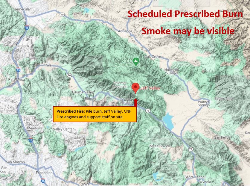
Image of Prescribed Fire Graphic with mountains in the background, fire, smoke, and firefighters using torches to ignite the fuels.
Trabuco Ranger District Fuel Treatment Update Week of 02 26 2024
Related Incident: 2025 - Cleveland National Forest, Forest Health Treatments
Publication Type: News
2/26/24 - The Cleveland National Forest (CNF) Trabuco Ranger District (TRD) is set to initiate prescribed fire preparation on the following projects:
Prescribed Fire Preparation:
Project:
North Main Divide -This week with more rain predicted today and tomorrow, work will be delayed by a few days until this passes. Once the roads are deemed safe to drive, we will continue prepping Unit 115. Los Pinos CCC are currently cutting and chipping in Units LC-7 and 8. OCFA Crew Santiago and El Toro will be constructing hand line on Units 93 and 74 in the near future.
Prescribed Fire:
No planned RX this week.
Palomar Ranger District Fuel Treatment Update Week of 02 26 2024
Related Incident: 2025 - Cleveland National Forest, Forest Health Treatments
Publication Type: News
Prescribed Fire Preparation:
North Ramona Fuel break (map 1) Urban Corp crews continue working on North Ramona West cut/pile work in the crosshatch, area as weather permits.
Fry Creek (map 2) – Crews may be working on various preparations for pile burning.
Jeff Valley (maps 3-5) – Crews may be working on handlines and various pile burn prep activities.
Palomar Fuel breaks (map 6) – Crews may be working on various preparations for burning.
*Morgan Hill (map 7) –Our staff will continue to evaluate if this is a project that we can begin implementing.
Prescribed Fire: Last week crews completed the pile burning on North Ramona (west), 95 acres burned in two days 1/19 & 1/20. All pile burning on the North Ramona FB is complete for this burn season - archaeological surveys can be completed anytime (west section).
Urban Corp has 13 acres of cut/pile work to complete and we plan to burn this 23-acre section just north of the dump next burn season (fall 24-winter 25), depending on when they finish.
We are setting up for pile burning in Jeff Valley Tuesday 2/29 – Friday 3/1 this week. Burning could occur in multiple units if we need to move to locations that are more receptive to burn (sheltered/different fuels).
We will continue to monitor weather, fuels, and access conditions for other burn projects. If conditions are not too wet after this next round of precipitation, next week could be an opportunity to enter Fry Creek, and/or the Palomar Fuel break projects.
North Ramona Fuel break – prescribed burning complete for the burn season.
Total acres burned on North Ramona FB to date: 258 acres.
Palomar Mt. Piles – prescribed burning may occur in Jeff Valley & Fry Creek, with available burn windows.
Burning could go multiple days with the right conditions.
Our priority burn area in Jeff Valley (140 acres) will be in piles adjacent to Conifer Rd. (Units 11, 12, 13, 14, 15, 9, 4, 6, and 18).
Our priority burn area in Fry Creek is Units 8a/b & 2a/b. We will likely burn in Jeff Valley as the priority over Fry Creek, but it is possible that we could burn piles in Fry Creek with snow on the ground.
Acres burned in Jeff Valley to date: 31 acres.
Palomar Fuel breaks – prescribed burning may occur with available burn windows.
Admin/Station Piles – pile burning could occur anytime conditions are favorable.