
Windy Deuce fire update 142,000 Acres02 29 2024
Related Incident:
Publication Type: Announcement
Windy Deuce Fire Update Thursday, February 29, 2024
Size: 142,000
Containment: 30%
Start Date: Monday, February 26, 2024
Cause: Under Investigation
The Windy Deuce fire is currently burning in Hutchinson County. Texas A&M Forest Service is currently working in unified command with the city of Fritch, Hutchinson County, and National Park Service. Crews are working to protect public lives, properties, and slow fire spread in high wind conditions.
Yesterday: Crews continued to construct containment line around the perimeter of the fire with heavy equipment. Single Engine Air Tankers (SEATS) were on scene making water and fire-retardant drops to aid in suppression of intense fire. Night operations consisted of one team of engines patrolling impacted residential areas to allow other local and state resources to rest and rehabilitate equipment.
Today: Early morning snow showers have allowed the opportunity for heavy equipment crews and engines to get into the interior zones of the fire and work on suppression tactics and construction of containment lines. However, this window of reprieve will not last long due to high winds returning and precipitation chances reducing over the course of the day. Aircraft remains available in Dumas and Abilene if needed. Crews will work diligently throughout the day and take advantage of the moisture increase.
Weather and Fire Behavior: Light snow showers in the morning have increased the moisture and relative humidity however wind speeds reduce that moisture availability throughout the day resulting in moderate fire behavior. Any hot spots remaining will reduce moisture in surrounding areas allowing for fire activity in the afternoon.
Evacuations: In the town of Fritch, the following neighborhoods have been evacuated: Alibates, McBride, Mullinaw, Harbory Bay, Chisolm Trail, Arroyo Grande, and Sage Brush. The City of Borger has opened two shelter locations: Church of Christ and Fairlands Baptist Church. In the City of Fritch, the shelter at Celebration Family Church is reduced in capacity. Evacuation for Double Diamond, Arrowhead Addition, and Maverick have been lifted.
Damages/Injuries: Structures have been confirmed lost at this time. This is an evolving situation and due to the complexity of the fire, there are no details on the number and type of structures that have been destroyed/damaged at this time. There are no reported injuries at this time.
Closures: No closures
Smokehouse Creek Fire Update02 29 2024
Related Incident:
Publication Type: Announcement
Smokehouse Creek fire updates
February 28th, 9:30 PM
Size: 850,000 acres
Containment: 0%
Cause: Under investigation
The Smokehouse Creek Fire has spread across multiple counties in the northeastern Texas panhandle and western Oklahoma. Personnel on the fire are continuously planning and adapting to the circumstances as more resources arrive. On February 28th, the fire was active, wind-driven, and creating Spotfire. There is currently moderate potential for growth as ground crews make slow progress with heavy equipment due to rough terrain. Official information will continue to be posted as it arrives.
Today: Crews along the fire have been working on containment lines along the perimeter, while other crews work on preventing more flare-ups within the previously burned areas. Local agencies are continuing to work to protect structures in the affected communities.
Tomorrow: Crews will continue work on the fire as more personnel and resources arrive. There is still potential for growth. Ground crews are moving along the fire with heavy machinery, but the rough terrain is causing slow progress.
Weather: Today's weather included light but variable surface winds that slowly shifted southerly. Tonight, wind speeds are forecasted to pick up to 10 to 15 mph. Chances for precipitation returns Thursday morning with the large fire perimeter currently having a 20 to 30% chance of seeing showers.
Evacuations: Evacuations and road closures have been lifted for the town of Canadian.
Damages: This is an evolving situation and due to the complexity of the fire, there are no details on the number and type of structures that have been affected at this time.
Windy Deuce Fire Evening update02 28 2024
Related Incident:
Publication Type: Announcement
Size: 142,000
Containment: 30%
Start Date: Monday, February 26, 2024
Cause: Under Investigation
Yesterday: Crews worked overnight to construct containment lines around the fire and slow the fire growth towards Amarillo. Engines and heavy equipment from Texas A&M Forest Service, National Park Service, and Hutchinson County worked to construct lines and slow fire spread. Additional engine worked last night to assess structures in the community of Fritch and along highway 136. They patrolled through neighborhoods and worked to ensure that no additional structures burned.
Today: Crews worked today to continue constructing containment lines around the perimeter of the fire. Heavy equipment such as bulldozers and motor graders worked to create lines of dirt around the perimeter of the fire so that there is no additional outward growth. Night operations will consist of one team of engines patrolling impacted residential areas to allow other resources to rest and start fresh Thursday morning.
Single engine air tankers (seats) were on scene today making water and fire-retardant drops to aid in the suppression of intense fire allowing the ground resources to construct line. Large areas of unburned grass, or fuel, remain so these areas are likely to still burn through the night. Todays large increase in acreage is due to more accurate mapping of the fire and impacted areas.
Weather and Fire Behavior: Winds are expected to remain calm through the night with elevated humidity. The wind is expected to remain low through Thursday with potential still present for precipitation tomorrow morning. Winds are expected to pick back up by the weekend.
Evacuations: In the town of Fritch, the following neighborhoods have been evacuated: Double Diamond, Arrowhead Addition, Maverick, Alibates, McBride, Mullinaw, Harbory Bay, Chisolm Trail, Arroyo Grande, and Sage Brush. The City of Borger has opened two shelter locations: Church of Christ and Fairlands Baptist Church. In the City of Fritch, the shelter at Celebration Family Church is reduced in capacity.
Damages/Injuries: Structures have been confirmed lost at this time. This is an evolving situation and due to the complexity of the fire, there are no details on the number and type of structures that have been destroyed/damaged at this time. There are no reported injuries at this time.
Closures: Highway 136 is closed on both sides of Fritch.
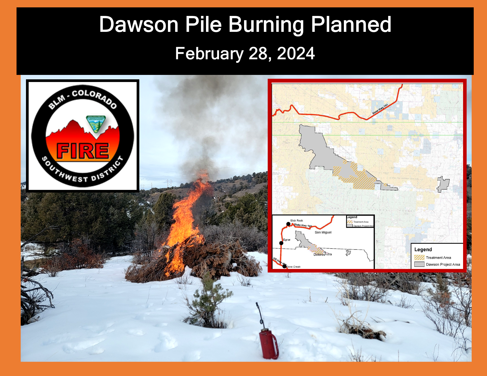
Firefighters burn 5 acres of piles at Dawson project 02 28 2024
Related Incident:
Publication Type: Announcement
Today, firefighters on the BLM Dawson project burned approximately 60 piles to accomplish 5 acres of treatment. Dawson project area is in Disappointment Valley,15 miles northeast of Dove Creek, CO.
Project is part of a pinyon-juniper woodland research being conducted on the response to thinning by studying the growth rates, understory response and soil moisture. Treatments also assist in reducing hazardous fuels to protect wildland-urban interface communities and to restore forest health.
Expect some light visible smoke in the area as vegetation in the interior continue to smolder and go out.
For more information on smoke, visit https://www.colorado.gov/pacific/cdphe/wood-smoke-and-health
For information on prescribed burns, visit the Southwest District BLM Prescribed Fire InciWeb page https://inciweb.nwcg.gov/incident/7852/ or follow us on Twitter https://twitter.com/SWD_Fire and Facebook http://www.facebook.com/BLMMontroseFireUnit
Windy Deuce fire update02 28 2024
Related Incident:
Publication Type: Announcement
Size: 90,000
Containment: 25%
Start Date: Monday, February 26, 2024
Cause: Under Investigation
The Windy Deuce fire is currently burning in Hutchinson County. Texas A&M Forest Service is currently working in unified command with the city of Fritch, Hutchinson County, and National Park Service. Crews are working to protect public lives, properties, and slow fire spread in high wind conditions.
Yesterday: Crews worked overnight to construct containment lines around the fire and slow the fire growth towards Amarillo. Engines and heavy equipment from Texas A&M Forest Service, National Park Service, and Hutchinson County worked to construct lines and slow fire spread. Additional engine worked last night to assess structures in the community of Fritch and along highway 136. They patrolled through neighborhoods and worked to ensure that no additional structures burned.
Today: Crews are out working today to continue constructing containment lines around the perimeter of the fire. Heavy equipment such as bulldozers and motor graders are working to create lines of dirt around the perimeter of the fire so that there is no additional outward growth. Additional fire engines are arriving today and will be working to protect structures and patrol through already burned areas to prevent any further structure loss.
Aircraft from Texas National Guard will be on scene today providing water drops to aid in suppressing areas of intense fire and heat so that ground resources can go direct into the area and construct lines. There area large areas of unburned grass, or fuel, inside of the burned area so some of these areas will continue to burn today and produce smoke.
Weather and Fire Behavior: Winds are lower today and have shifted to come out of the south. With lower winds and lower humidities firefighters are taking advantadge of lower fire behavior to construct containment lines around the perimeter. Winds are expected to stay low through tomorrow with a slight chance of precipitation tomorrow morning. Winds are expected to pick back up by the weekend.
Evacuations: In the town of Fritch, the following neighborhoods have been evacuated: Double Diamond, Arrowhead Addition, Maverick, Alibates, McBride, Mullinaw, Harbory Bay, Chisolm Trail, Arroyo Grande, and Sage Brush. The City of Borger has opened two shelter locations: Church of Christ and Fairlands Baptist Church. In the City of Fritch, the shelter at Celebration Family Church is reduced in capacity.
Damages/Injuries: Structures have been confirmed lost at this time. This is an evolving situation and due to the complexity of the fire, there are no details on the number and type of structures that have been destroyed/damaged at this time. There are no reported injuries at this time.
Closures: Highway 136 is closed on both sides of Fritch.
Yuba River Ranger District Camp Handpiles02 28 2024
Related Incident:
Publication Type: Announcement
Tahoe National Forest's Yuba River Ranger District will be burning 5 acres of handpiles today, Feb. 28, 2024. This unit is located off Moonshine Rd., 1 mile south of Marysville Rd. Smoke will be visible from Bullards Bar, North San Juan, Camptonville and surrounding areas. Smoke impacts are expected to be minimal.
Smokehouse Creek Fire road Update02 28 2024
Related Incident:
Publication Type: Closures
As of 12:40 Febuary 28th, evacuations and road closures have been lifted for the town of Canadian.
Jeff Valley RX Palomar Ranger District 02 28 2024
Related Incident: 2025 - Cleveland National Forest, Forest Health Treatments
Publication Type: News
2/28/24 – The Cleveland National Forest Palomar Ranger district will be conducting a prescribed burn on the Jeff Valley fuel project, contingent on weather and environmental conditions. Residents and visitors will see smoke visible throughout the day around Palomar Mountain, Escondido, Pala, Valley Center, and surrounding communities. Please DO NOT REPORT.
The California Climate Investment grant and the Presidents Inflation Reduction Act which is a part of confronting the wildfire crisis., supporting the Wildfire Crisis Strategy.
Prescribed Fire is part of Confronting the Wildfire Crisis: https://fs.usda.gov/managing-land/wildfire-crisis. Prescribed fire plays an important role in forest health and in reducing extreme wildfires and their negative impact. These fires also help reduce heavy fuel loads while simultaneously opening the conifer forest structure and maintaining the health of meadow habitats. Fire is also used to enhance native plant communities and cultural landscapes and improve wildlife habitats. Another goal is to provide defensible space for communities and developed areas within and surrounding the CNF. With all fire comes smoke, and the U.S. Forest Service works to mitigate smoke impacts from prescribed fires on the communities in the area.
#prescribedBurn #PrescribedFire #ForestHealth #wildifrecrisis
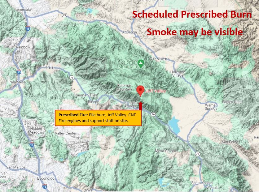
Image of Prescribed Fire Graphic with mountains in the background, fire, smoke, and firefighters using torches to ignite the fuels.
Smokehouse Creek Fire Update 02 28 2024
Related Incident:
Publication Type: Announcement
Smokehouse Creek fire updates
February 28th, 9:00am
Size: 500,000 acres
Containment: 0%
Cause: Under investigation
The Smokehouse Creek Fire has spread across multiple counties in the northeastern Texas panhandle and western Oklahoma. Personnel on the fire are continuously planning and adapting to the circumstances. Safety continues to be the top priority for the ongoing operation, for both residents and working personnel. Several crews worked in Canada, and Miami, to place control lines around the towns. Local departments are working to defend structures from fire. Several structures have been damaged and no further details are available at the time.
Weather
As of 7:00 am February 28th, Wind speeds throughout the area have decreased and the humidity has risen substantially. Northwest winds are predicted throughout the morning, shifting to the east around 6 mph late in the afternoon, then shifting to the south late in the afternoon. Precipitation is possible for the perimeter of the fire during Thursday.
Evacuations
The following locations are available for evacuees who have gone east:
Fort Supply Baptist Church, 219 Sheridan, Fort Supply, OK
Roger Mills County Courthouse, 500 E Broadway, Cheyenne, OK
Vici Community Room, 604 Main Street, Vici, OK
Woodward Conference Center, 3401 Centennial Drive, Woodward, OK
Pile burning continues at Dawson project area 02 28 2024
Related Incident:
Publication Type: Announcement
If conditions allow firefighters plan to continue prescribe pile burning on February 28, 2024, in the Dawson project area on Tres Rios Field Office BLM-managed lands located 15 miles northeast of Dove Creek, CO in Disappointment Valley.
Piles are from a previous treatment in the Dawson Research Units. These units are a part of a pinyon-juniper woodland research being conducted on the response to thinning by studying the growth rates, understory response and soil moisture. Treatments also assist in reducing hazardous fuels to protect wildland-urban interface communities and to restore forest health.
The project area has a detailed burn plan that outlines the parameters for prescribed burning and contains specific criteria regarding weather conditions and air quality that must be met to ensure control of the burn, as well as minimizing the potential smoke impact to local communities.
The prescribed burn may take multiple days to complete once initiated and will be monitored after completion to ensure public safety. While smoke may be visible in the area at times, most of the smoke will lift and dissipate during the warmest parts of the day. Expect visible smoke in the area for several days after each burn is completed as vegetation in the interior continues to smolder.
For more information on smoke, visit https://www.colorado.gov/pacific/cdphe/wood-smoke-and-health
For information on prescribed burns, visit the Southwest District BLM Prescribed Fire InciWeb page https://inciweb.nwcg.gov/incident/7852/ or follow us on Twitter https://twitter.com/SWD_Fire and Facebook http://www.facebook.com/BLMMontroseFireUnit