
Royal Fire Update 2 07 09 2024
Related Incident:
Publication Type: Announcement
Size: 200 acres
Containment: 0%
Start Date & Time: July 7, 2024, 1609 PDT
Cause: Unknown / Under Investigation
Location: 5 miles south of Soda Springs, Calif. Royal Gorge, North Fork of the American River
Suppression Strategy: Full Suppression
CURRENT SITUATION
The Royal Fire did not experience significant growth overnight. Reported acreage is due to more accurate mapping by FIRIS. There has been little progress on containment due to extremely steep and difficult to access terrain. The fire is currently boxed in with retardant. Significant aerial resources continue to monitor and attack the incident. Ground crews continue to work on building handline and dozer line around the fire.
The fire is active with crews reporting short-range spotting, tree crowning and short uphill runs. High-pressure and extreme heat is expected over the fire area for the next several days. Low humidity and dry fuels are contributing to resistance of containment measures.
The Tahoe National Forest has issued a closure for the fire footprint and surrounding fire area for the safety of the public and firefighter personnel.
Current resources assigned to the Royal Fire include: 1 Type 2 helicopter, 6 Type 1 helicopters including 2 Type 1 night-flying water dropper, 2 night-flying capable UAS (drones), 1 Type 3 hoist-capable helicopter, 24 crews, 16 engines, 5 dozers and several support staff (overhead).
CLOSURES
Tahoe National Forest has issued Forest Order 17-24-11
The Royal Fire Closure Area boundary begins at the intersection of Serene Road and Soda Springs Road (County Road 6001). The boundary follows the Soda Springs Road south and then west and south to the junction of Mosquito Ridge Road (Forest Road 96). The boundary then continues northwest for approximately 5 miles until it reaches the western terminus of the Long Valley Trail (Forest Trail 14E29). The boundary then travels along the Long Valley Trail east to the intersection of Long Valley and Palisades Creek Trail (Forest Trail 14E14) and then continues north along the Palisades Creek Trail to the intersection with Kidd Lakes Road (County Road 9146). The boundary then travels southeast from the Palisades Creek Trailhead for approximately 3 miles back to the starting point at Serene Road and Soda Springs Road.
EVACUATIONS
• Placer County Sheriff’s Office has not issued any additional evacuation orders or warnings.
• An evacuation warning remains for the community of the Cedars.
RESOURCES
The County of Placer encourages resident and visitors to sign up for Tahoe Alerts. Tahoe Alerts is a one-stop resource for the various emergency alert systems available in different regions around Lake Tahoe, encompassing Placer, El Dorado, Nevada, Douglas, Alpine, and Washoe counties, as well as Truckee, Carson City and South Lake Tahoe.
INCIDENT HISTORY
The Royal Fire was reported July 7, 2024 at 4:09 p.m. in the area of Royal Gorge on the North Fork of the American River on the Tahoe National Forest. The fire is located in steep, rugged terrain that is difficult to access. Tahoe National Forest immediately responded to the incident with aggressive aerial resources. Ground crews continue to reinforce incident objectives to suppress and contain the fire as quickly as possible.
The U.S. Forest Service-Tahoe National Forest is in unified command with Placer County Sheriff's Office, CAL FIRE NEU /Placer County Fire and Placer County Government Office of Emergency Services on the Royal Fire incident.
Oak Ridge Fire Update 07 09 0024
Related Incident: Oak Ridge Fire
Publication Type: News
Yesterday afternoon, some smoke was visible in Div. U. This smoke was well within the fire containment lines and posed no threat to the lines. Smokes will continue to be visible within the fire perimeter when weather and fuel conditions align. Firefighters on the ground and aerial resources will continue to monitor the fire. Until the fire is fully contained firefighters will be monitoring fire activity, repairing suppression impacts and backhauling equipment from the line.
Aviation resources including fixed wing aircraft, helicopters and unmanned aircraft systems (UAS) have played a valuable role in with the Oak Ridge Fire. To date, a total of 402,674 gallons of water and 19,044 gallons of fire retardant have been dropped on the fire. The UAS dropped 1,222 dragon eggs (plastic spheres that chemically react to ignite) in Div. K to assist firefighters with the strategic firefighting operation. A total of 19,910 pounds of cargo has been backhauled from the fireline.
This evening, there will be a transfer of command from the Rocky Mountain Area Complex Incident Management Team 3 (RMA CIMT3) to a Type 3 Incident Management Organization. The new team is comprised mainly of members from the outgoing team with on the ground experience of the fire. RMA CIMT3 would like to thank the local cooperators and public for their understanding, cooperation and patience during the fire. The management of the fire has endured adaptations in strategies with the overall goals will continue to be to protect firefighter safety, the community of Beulah and the Middle Creek Watershed.
The public is encouraged to continue going to Facebook and Inciweb for updated information on the Oak Ridge Fire. Also, boards at the Beulah General Store and Beulah Fire Department will continue to be posted with updated information.
Weather & Smoke Information: Isolated showers and thunderstorms are expected over the Wet Mountains Tuesday and Wednesday afternoons with a 30% chance of precipitation hitting the fire. Today’s temperatures will reach 83 with relative humidity levels reaching as low as 29%. Winds will be west to east/southeast with gusts up to 14 mph. The U.S. Interagency Wildland Fire Air Quality Response Program daily smoke outlook report specific to the fire area may be found at https://outlooks.airfire.org/outlook/d9fa3c77.
Closures: The San Carlos Ranger District of the Pike and San Isabel National Forests issued an area, trail and road closure effective June 26, 2024. Go to www.fs.usda.gov/alerts/psicc/alerts-notices for the entire order.
Evacuations: There are currently no evacuations from county sheriff offices due to the Oak Ridge Fire.
Temporary Flight Restrictions: The is a 24-hour a day Temporary Flight Restriction (TFR) over the fire area remains in effect. The TFR includes restrictions against private drones and all air incursions will be reported to law enforcement.
Pius Fire Update Monday July 08 202407 09 2024
Related Incident: Pius Fire
Publication Type: News
Pius Fire Update
Monday, July 08, 2024
Location of Origin: 20 miles NE of Payson AZ
Size: 460 acres
Start Date: July 8, 2024
Percent Contained: 0
Cause: Undetermined
Fuels: Ponderosa Pine/Mixed Conifer
Personnel: 76
Resources Assigned: 1 Initial Attack Crew, 4 Helicopters, 4 Engines, 5 Dozers, 1 Water Tender
The Pius fire is located on the Black Mesa Ranger District, and is located southeast of the CC Cragin Reservoir, southwest of Wiggins Crossing, and north of Black Canyon Lake. The fire is currently managed under a Type 3 Incident Command structure with a full suppression strategy. Fire behavior exhibited extreme intensity today and was actively running, crowning to the tops of trees, and spotting ahead of the main fire. As a result of the increased growth and behavioral complexity, the Complex Incident Management Team, Team 1, led by Incident Commander Carl Schwope, will join in a formal in-brief on July 9 regarding the operational status of the Pius fire, and will assume command of the Pius fire at 6 a.m. on July 10, 2024.
Operations: The Pius fire is expected to continue to move to the south and southeast. Firefighting resources will look to establish an anchor point and will be using indirect and direct-attack tactics to establish flanking opportunities along the perimeter when it is safe to do so.
Evacuations: The Coconino County Sheriff’s Office has issued a “GO” status to evacuate immediately for people in and around Bear Canyon Lake and Knoll Lake including the areas north of Forest Road (FR)300, east of FR115, south of FR225, and west of FR34. The public is encouraged to follow the Ready, Set, Go! program to prepare for any threats to their community. Go to https://311info.net/ for accurate and timely status updates.
Smoke: Smoke is expected to impact the communities of Christohper Creek, Payson, Young, Forest Lakes, Heber-Overgaard, and Highway 260. All areas within proximity of the fire can be impacted by smoke, depending on wind directions and ventilation. Go to fire.airnow.gov/ to see the latest smoke conditions in your community.
Values at Risk: KV Powerlines are located roughly 4 miles southeast of the fire and supplies power to the Phoenix Metropolitan area. There are private inholdings in proximity to the fire location. Recreation areas along the Rim Lakes are located roughly 5 miles south of the fire location.
Weather: Hot and dry conditions are expected to continue with highs on July 9 expected to be 94 degrees. The forecast is calling for a slight chance of showers and thunderstorms with winds shifting from the southwest to the northwest at 10-15mph.
Settings - change map background and toggle additional layers
Filter - control incident types displayed on map.
Zoom to your location
Reset map zoom and position
Could not determine your location.
Show Legend
 Wildfire
 Prescribed Fire
 Burned Area
Response
Burned Area
Response Other
Other
Pius Fire
Unit Information
Incident Contacts
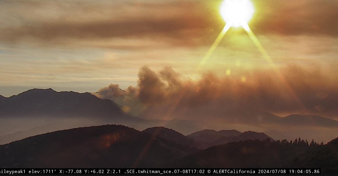
Vista Fire evening update 07 08 2024
Related Incident: Vista Fire
Publication Type: News
#VistaFire Update: This fire is managed under a full suppression strategy. Fire is burning in brush and timber within steep and rugged rocky terrain, making access difficult in some areas. Fire behavior was active on all fronts today and established in Cold Water Canyon and made significant uphill runs to the west. Crews attacked the fire from the ground and air, using fire engine modules to suppress the fire with hose lays, as hotshot crews and dozers cut line around the fire's perimeter. Aircraft were used to slow the progression at the head and flanks of the fire so crews could engage and cut line. The Mt. Baldy Resort has been evacuated as the area is still threatened. Poor air quality is impacting the community of Mt. Baldy. Visit AirNow.gov for information. Lytle Creek Road remains closed to the public, with access only to local residents. High temperatures continue to be a concern to firefighters as forecasts call for the same. This evening, the San Bernardino County Fire Department returned to Unified Command as the fire threatened Mt. Baldy. At 0600 tomorrow morning, California Complex Incident Management Team 15 will take command of the fire. The fire acreage will remain at 588 acres until an IR flight can be made.
Royal Fire Update 1 07 08 2024
Related Incident:
Publication Type: Announcement
Air Attack is reporting the Royal Fire at 154 due to more accurate mapping. The fire has continued to hold within its footprint throughout the day and remains at 0% containment. Tankers have boxed the fire in with retardant. Three Type 1 helicopters have been performing water drops throughout the day. Crews have gained access to the incident and constructed handline across the head.
The cause of the fire remains under investigation.
As previously reported by Placer County’s Sheriff’s Office, the unaccounted-for hikers were found safely.
Evacuation warnings remain for the community of The Cedar’s. No additional evacuation warnings or orders have been issued today.
Tahoe National Forest is in unified command with CAL FIRE/Placer County Fire Department and Placer County Sheriff’s Office. View evacuation information: Placer County Sheriff's Office - Public Safety Map (arcgis.com)
Settings - change map background and toggle additional layers
Filter - control incident types displayed on map.
Zoom to your location
Reset map zoom and position
Could not determine your location.
Show Legend
- Wildfire
- Prescribed Fire
- Burned Area
Response
- Other
Salt Creek
Unit Information
Incident Contacts
Settings - change map background and toggle additional layers
Filter - control incident types displayed on map.
Zoom to your location
Reset map zoom and position
Could not determine your location.
Show Legend
- Wildfire
- Prescribed Fire
- Burned Area
Response
- Other
Billy Creek Fire
Unit Information
Incident Contacts
Settings - change map background and toggle additional layers
Filter - control incident types displayed on map.
Zoom to your location
Reset map zoom and position
Could not determine your location.
Show Legend
- Wildfire
- Prescribed Fire
- Burned Area
Response
- Other
Wilder Fire
Unit Information
Incident Contacts
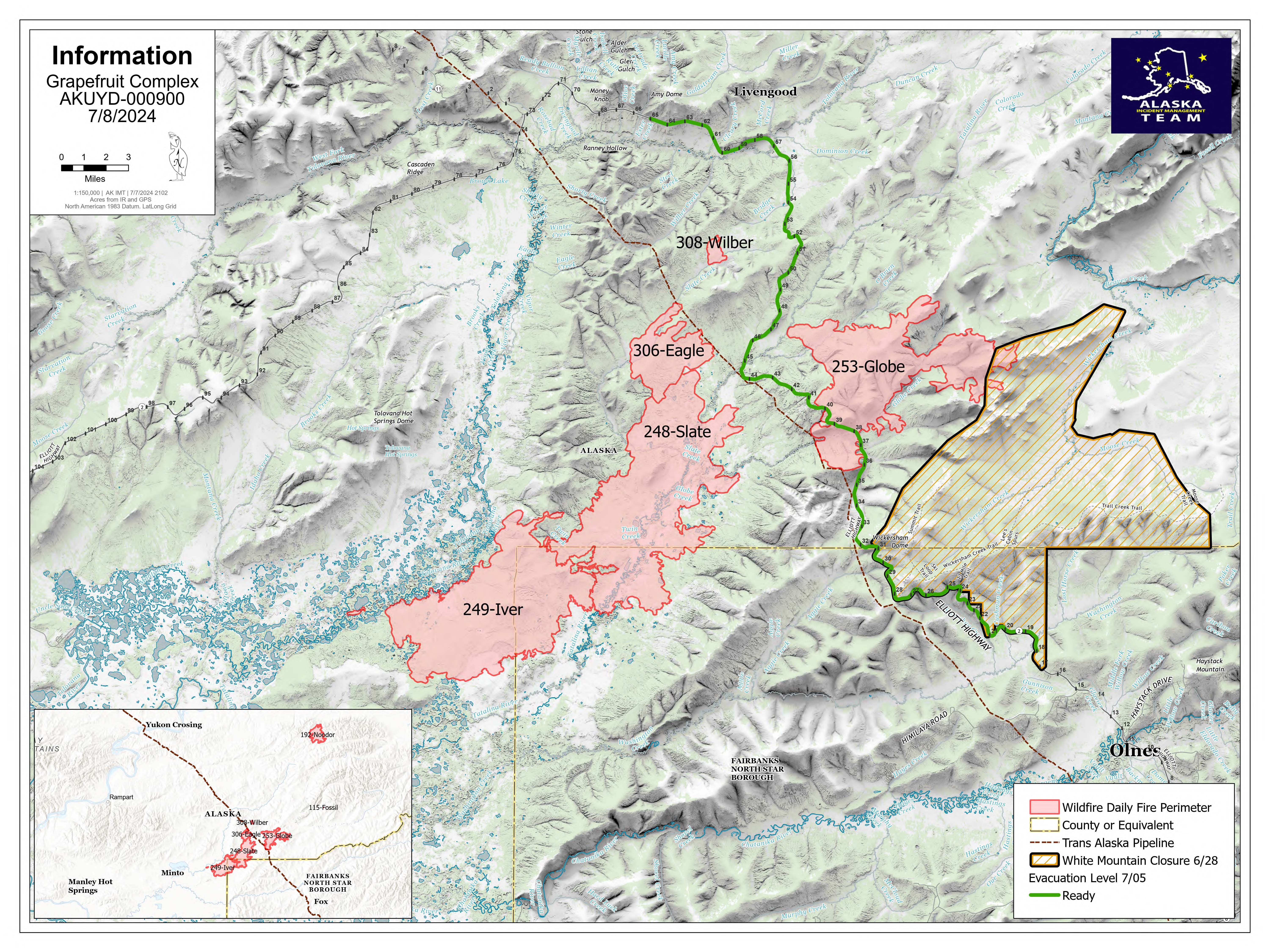
Grapefruit Complex Daily Update 07 08 2024
Related Incident: Grapefruit Complex
Publication Type: News
Grapefruit Complex
Daily Update: Monday, July 8, 2024
Alaska Incident Management Team 3
Incident Commander- Peter Butteri
Location: 40 Miles north of Fairbanks
Complex Acres: 87,434
Personnel: 236
Containment: 0%
Completed Structure Preparation: 85%
Crews are working toward finalizing structure protection measures, documenting assessment data, and collecting equipment no longer needed for operations. The work around the Native Allotments, included utilizing a masticator and crews to put in a fire break, has been completed. Slight showers continued to fall over the area Sunday, and 2-4” of rain were measured in the days since the rain event began. The forecast for Monday predicts drier conditions with only a chance of light rain over the fire. Partly cloudy skies with chilly temperatures are expected. Temperatures will be in the low to mid-40s, with highs struggling to reach 60. Minimum relative humidity will be 50% or higher. Winds will continue from the southwest, with gusts to around 18 mph.
The Grapefruit Complex includes the Globe Fire (#253), Iver Fire (#249), Eagle Fire (#306), Wilber Fire (#308), Noodor Fire (#192), and Fossil Fire (#115). Crews continue to limit the fire’s impact on the Elliott Highway, Trans-Alaska Pipeline, Native allotments, and public and private structures, as well as reducing impacts to fish habitat along the Tatalina and Tolovana River corridors.
Evacuations: The current levels are represented as: Ready (Green): Elliot Hwy MM 18-65 / Set (Yellow): None currently. / Go (red): None currently.
Smoke: The fire perimeter is unlikely to change. However, as daytime temperatures rise and fuels dry out, some of the fuels that held heat through the rain event may produce smoke. Turning on your headlights is advised to help ensure the safety of firefighters and flaggers working in the area.
Road access: The Elliott Highway is open. Expect delays between mileposts 25-65 as firefighters work to remove equipment from the Wickersham Dome trailhead area. Alaska Department of Transportation & Public Facilities temporarily repaired the road due to flooding at milepost 57, utilizing one lane and pilot cars to facilitate traffic flow. DOT is working on logistics for two 12-hour road closures, which could begin as early as Today, July 8th. Check https://511.alaska.gov/ for additional road updates.
Temporary Flight Restriction: No TFRs are in place over the fire area.
Closures: The Bureau of Land Management (BLM) Eastern Interior Field Office closed the western portion of the White Mountains National Recreation Area surrounding the Wickersham Dome Trailhead at mile 28 Elliott Highway. The closure is in effect until Sept. 1, unless the BLM determines the area is safe for public use at an earlier time.
