
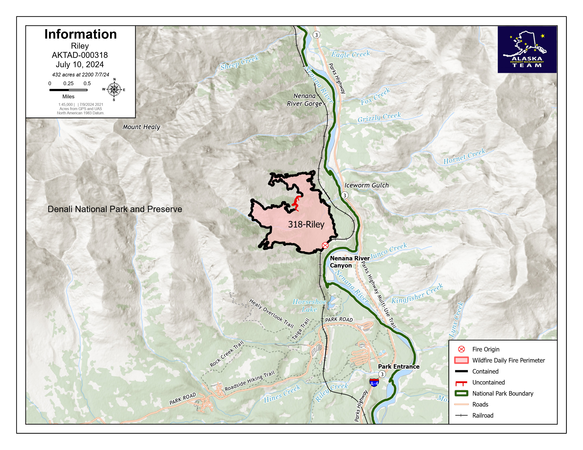
Denali National Park resumes normal operations 07 10 2024
Related Incident: Riley Fire
Publication Type: Announcement
HEALY, Alaska – As of today, Denali National Park and Preserve is open and returning to normal operations. The National Park Service and Denali National Park Tours Doyon/Aramark Joint Venture welcomed visitors back to the park this morning. However, Riley Creek Campground, Riley Creek Day Use Area, the Horseshoe Lake Trail, and Mt. Healy Overlook trail will remain closed due to firefighting support activities in the area. Furthermore, the Alaska Railroad and Denali Depot returned to normal full-service operations on this morning.
Go to the Denali National Park and Preserve website for additional information. Park Information Line: 907-683-9532, 8 a.m. - 4:30 p.m., daily.
Firefighters continued to mop-up the fire’s edge yesterday with the assistance of un-crewed aircraft systems (UAS) infrared heat sensing technology. Minimal smoke is visible; however, smoke may be evident as temperatures increase in the coming days. The Riley Fire will transition tomorrow at 7:00 a.m to a type 3 organization, with many Alaska Incident Management Team 2 members remaining to assist with fire management.
Weather: A slight warming and drying trend begins today and is expected to last until the weekend. Winds will be out of the southwest 10-15 mph with a 10% chance of precipitation.
Fire Investigation: The National Park Service is requesting information from anyone who may have witnessed the initial stages of the Riley Fire, specifically between the hours of 11:30 a.m. and 12:30 p.m. on Sunday, June 30, 2024. Anyone who was in the vicinity of the Horseshoe Lake Trail, Mt. Healy Trail, Sugarloaf Trail, or on the southbound passenger train during that time and has information relating to the fire should contact the Tip Line at 888-653-0009.
Evacuations: All evacuation statuses have been lifted as of 8:00 p.m on Tuesday July 9th, 2024.
Temporary Flight Restrictions: A temporary flight restriction (TFR) remains in place over the Riley Fire until July 19th. Find more information at: 4/7281 NOTAM Details (faa.gov). It’s important to keep all unidentified aircraft out of the TFR area. If illegal drone use is detected over the fire area, all firefighting aerial resources are grounded immediately and may delay suppression progress.
Actualizacin Diaria de Basin Fire para el 10 de Julio de 2024 07 10 2024
Related Incident: 2024 Lake Fire
Publication Type: News
Inicio del Incendio Lake: viernes, 5 de julio de 2024 a las 3:48 p.m.
Causa: Bajo investigación
Ubicación: Cerca del Lago Zaca en el condado de Santa Barbara al norte de Los Olivos, California
Tamaño en el momento de la actualización: 28,987 acres
Contención: 16%
Personal: 2767
Detalles completos del Incidente: https://inciweb.wildfire.gov/incident-information/calpf-2024-lake-fire
Medios de comunicación: Las fotos y vídeos oficial del Incendio Lake 2024
Actividad actual del incendio: En general, una noche tranquila en el incendio. Las operaciones de tiro táctico continuarán por delante del incendio para controlar su propagación. La significativa actividad del incendio en el lado sureste de la huella del incendio ha provocado evacuaciones adicionales y un aumento de acres. Desde el inicio del Incendio Lake, 1,500 personas han sido evacuadas. Ha habido algunos bomberos heridos, pero no han sido de gravedad mayor. La respuesta médica ha sido rápida y eficaz, ya que la seguridad de los bomberos sigue siendo la máxima prioridad. Continúa la alerta por calor excesivo en la zona del incendio.
Antecedentes del Incendio Lake: El 5 de julio de 2024, los bomberos del Bosque Nacional de Los Padres y los Bomberos del Condado de Santa Bárbara respondieron a un incendio de vegetación cerca del Lago Zaca que creció rápidamente a través de la hierba y la maleza durante una prolongada ola de calor en toda la costa oeste. Un número significativo de recursos de extinción de incendios están trabajando en el incidente, incluyendo equipos de mano, motores, topadoras, y los recursos aéreos para el agua y lanzamientos retardantes. El incendio está bajo Mando Unificado con el Equipo 13 de Gestión de Incidentes Complejos de California, Bomberos del Condado de Santa Bárbara y CAL FIRE.
A partir del martes, 9 de julio, las siguientes áreas se han actualizado para ADVERTENCIAS DE EVACUACIÓN debido a las amenazas a la vida y la seguridad causada por el Incendio Lake.
ADVERTENCIA DE EVACUACIÓN emitida para el área que comienza en el extremo sur del Arroyo Cachuma, al noreste del Arroyo Santa Cruz hasta el Pico Santa Cruz, al oeste a través de Grand Spring, y hasta la parte norte del Arroyo Cachuma, debido al Incendio Lago. Estén preparados para salir.
INFORMACIÓN COMPLETA DE EVACUACIÓN: https://www.readysbc.org/4275/Lake-Fire-Incident---July-2024
REGÍSTRESE PARA RECIBIR ALERTAS DE ReadySBC: Si no se ha registrado para recibir alertas de emergencia, regístrese ahora en ReadySBC.org. Reciba alertas de emergencia locales por mensaje de texto, llamada telefónica y correo electrónico.
Cierre de carreteras:
- Happy Canyon Road en el límite del Servicio Forestal
- Foxen Canyon Road en Zaca Station Road y Alisos Canyon Road
- Figueroa Mountain Road en la Escuela Midland
Lake Fire Daily Update for July 10 2024 07 10 2024
Related Incident: 2024 Lake Fire
Publication Type: News
Lake Fire Start: Friday, July 5, 2024 at 3:48 p.m.
Cause: Under Investigation
Location: Near Zaca Lake in Santa Barbara County north of Los Olivos, California
Size at time of update: 28,987 acres
Containment: 16%
Personnel: 2767
Full Incident Details: https://inciweb.wildfire.gov/incident-information/calpf-2024-lake-fire
Media Assets: Official 2024 Lake Fire Photos and Videos
Current Fire Activity: Overall, a quiet night on the fire. Tactical firing operations will continue ahead of the fire to control fire spread. Significantfire activity on the southeast side of the fire footprint has prompted additional evacuations and an increase in acreage. Since the start of the Lake Fire, 1,500 people have been evacuated. There have been some firefighter injuries but they were not life threatening. Medical response has been quick and effective as firefighter safety remains the top priority. An excessive heat warning continues in the fire area.
Lake Fire Background: On July 5, 2024, firefighters from the Los Padres National Forest and Santa Barbara County Fire responded to a vegetation fire near Zaca Lake that grew rapidly through grass and brush during a prolonged heat wave across the west coast. A significant number of firefighting resources are working the incident, including hand crews, engines, dozers, and air resources for water and retardant drops. The fire is under Unified Command with California Complex Incident Management Team 13, Santa Barbara County Fire and CAL FIRE.
Effective Tuesday, July 9, the following areas have been updated for EVACUATION WARNINGS due to threats to life and safety caused by the Lake Fire.
EVACUATION WARNING issued for the area starting at the south end of Cachuma Creek, northeast of Santa Cruz Creek to Santa Cruz Peak, west through Grand Spring, and to the northern part of Cachuma Creek, due to the Lake Fire. Be prepared to leave.
FULL EVACUATION INFORMATION: https://www.readysbc.org/4275/Lake-Fire-Incident---July-2024
REGISTER TO RECEIVE ReadySBC ALERTS: If you haven’t registered for emergency alerts, register now at ReadySBC.org. Receive local emergency alerts via text, phone call, and email.
Road Closures:
- Happy Canyon Road at the Forest Service Boundary
- Foxen Canyon Road at the Zaca Station Road and Alisos Canyon Road
- Figueroa Mountain Road at Midland School
Shelly Fire Morning Update 07 10 2024
Related Incident: Shelly Fire
Publication Type: News
Location: Siskiyou County, CA
Size: 8,285 acres
Cause: Under Investigation
Start Date: Wednesday July 3, 2023, at 1:27PM
Percent Contained: 0%
Personnel: 2,049
CURRENT SITUATION:
Yesterday, a smoke inversion helped to slow the growth of the Shelly Fire. This allowed personnel to strengthen dozer and hand lines around the fire perimeter. The fire remained active, particularly expanding to the north and east.
Crews successfully completed hand and dozer lines and established hose connections from Quartz Valley to Whiskey Butte to protect communities at risk, aiming to prevent the fire from spreading into Quartz Valley and Scott Valley. On the southern end, efforts are focused on completing hand and dozer lines from Sawyer Bar Road to the Pacific Crest Trail and Sawyer Bar Road to Snoozer Ridge. Minimal growth has been observed in southern and western areas in recent days.
Today, crews will continue to use aerial resources to strengthen fire lines. Ground teams on the northern front will explore further opportunities for containment, extending west on Scott River Road towards Boulder Peak. They will also continue strengthening line in the Shackleford and Patterson Creek drainage areas and engage directly in firefighting operations in the Mill Creek Ridge area. At the same time, they are reinforcing structure defense plans, in the Scott Valley area.
Evacuation orders or warnings have been issued for over 1,200 residential and commercial properties, affecting nearly 3,000 people in the area.
WEATHER:
Hot, dry, and unstable conditions persist, with an excessive heat warning in effect through this evening. Temperatures will cool slightly through the remainder of the week but remain well above normal with minimum relative humidity in the mid to upper teens and overnight recoveries slowly increasing to 30-40%. Enhanced terrain-driven up-canyon winds will continue each afternoon, with westerly down-canyon late afternoon to evening winds strengthening substantially Wednesday and continuing through the end of the week. There is a slight chance of thunderstorms Friday afternoon and evening, with isolated fairly dry thunderstorms becoming more likely on Saturday.
EVACUATIONS:
Multiple Evacuation orders and warnings remain in effect. For current updates on evacuations, visit www.facebook.com/SiskiyouCountySheriff and www.facebook.com/SiskiyouCountyOES
Additional evacuation information and a map can be found on the Genasys site at: https://protect.genasys.com/search?z=14&latlon=41.550694%2C-122.905589
SHELTERS:
Kahtishraam Wellness Center - Yreka
1403 Kahtishraam, Yreka, CA 96097
Showers and cots are available.
RV Dry Camping/Parking
West Webb St. and Hoag St. in Montague
Please note, at this time, there are no extra services (sewage/water/power hookups). This is currently set up for DRY camping.
𝗔𝗡𝗜𝗠𝗔𝗟 𝗦𝗛𝗘𝗟𝗧𝗘𝗥𝗦
Animal shelters are available at the following locations(s) for those who have pets and animals that been displaced due to the Shelly Fire:
Dog Evacuation Shelter:
Rescue Ranch Yreka
2216 East Oberlin Road, Yreka CA 96097
Contact: John Golay 541-698-7526
Livestock Animal Evacuation Shelter (Horses, pigs, sheep, goats, birds):
Siskiyou Golden Fair
1712 Fairlane Road, Yreka, CA 96097
Contact: Tom Taylor 530-340-1038
Cat Evacuation Shelter:
Siskiyou Golden Fair - Armory Building
1712 Fairlane Road, Yreka, CA 96097
Contact: Becca 530-340-0656
CLOSURES:
An official closure area around the Shelly Fire went into effect on July 4th. Hikers are not permitted in the area and will be asked to leave the area. For details and a map of the closure are, please visit https://www.fs.usda.gov/Internet/FSE_DOCUMENTS/fseprd1187463.pdf.
FIRE RESTRICTIONS:
Forest fire restrictions also went into effect on July 4th. Campfires and stove fires are restricted to those developed areas listed in the forest order located at https://www.fs.usda.gov/alerts/klamath/alerts-notices/?aid=88596. Smoking, welding, and operating an internal combustion engine also has restrictions in place.
Pacific Crest Trail Information: https://www.pcta.org/discover-the-trail/closures
Sheering Fire Map 07102024 07 10 2024
Related Incident: 2024- Sheering Fire
Publication Type: News
Latest map showing the 89% containment.
Informacin Actual del Incendio Oak Ridge 07 10 2024
Related Incident: Oak Ridge Fire
Publication Type: News
Durante la tarde del 9 de julio, un Equipo de Manejo de Incidentes Tipo 3 tomó el mando del incendio de Rocky Mountain Area Complex Incident Management Team. El nuevo equipo está compuesto por miembros que ya estaban trabajando en el incendio Oak Ridge, así como nuevos recursos. La cantidad y los tipos de recursos contraincendios continuarán ajustándose a medida que se complete el trabajo y se reduzca el riesgo del incendio.
La prioridad actual para el incendio Oak Ridge seguirá siendo la reparación de supresión. La reparación de supresión implica la reparación/restauración de áreas afectadas por los esfuerzos de extinción de incendios. Los ejemplos incluyen la instalación de barras de agua en las líneas cortafuegos para disipar el agua durante las lluvias. En DIV. A., astillando y dispersión de matorrales que se despejó durante la instalación de líneas cortafuegos continúa. El retroceso de los equipos continúa con la retirada de los elementos de protección de estructuras de las zonas afectadas a el puesto de mando del incidente. Todos estos esfuerzos ayudan a devolver el paisaje a las condiciones previas a las actividades contraincendios, en la mejor medida posible. Los gerentes de incendios están trabajando en estrecha colaboración con asesores de recursos para garantizar que esto se complete cumpliendo con los estándares recomendados.
El incendio Oak Ridge ardió principalmente en un patrón de mosaico, lo que significa que hay áreas de combustibles quemados y no quemados dentro del perímetro del incendio. A medida que el área avanza hacia una tendencia de calentamiento hasta el fin de la semana, estos combustibles pueden arder y continuar produciendo humo.
Información sobre Condiciones climáticas y de humo: El incendio recibió hasta 1/10” de lluvia anoche. Hay menos de 30% de posibilidades de que el incendio reciba precipitaciones hoy. Las condiciones comenzarán a secarse y a calentarse a partir del jueves. Las temperaturas alcanzarán los 84 grados hoy con humedades relativas tan bajas como el 24%. Después del mediodía, los vientos cambiarán a ser del sureste y tendrán ráfagas de hasta 16 mph.
El informe diario de perspectivas de humo del Programa Interinstitucional de Respuesta a la Calidad del Aire de Incendios Forestales de EE. UU. específico para el área del incendio se puede encontrar en https://outlooks.airfire.org/outlook/d9fa3c77.
Cierres: El Distrito de Guardabosques San Carlos de los Bosques Nacionales Pike y San Isabel pronunció un cierre de áreas, senderos y caminos a partir del 26 de junio de 2024. Visite www.fs.usda.gov/alerts/psicc/alerts-notices para ver la orden completa.
Evacuaciones: Actualmente no hay evacuaciones de las oficinas del sheriff del condado debido al incendio Oak Ridge.
Restricciones de vuelo temporales: Hay una restricción de vuelo temporal (TFR) las 24 horas del día sobre el área del incendio. El TFR incluye restricciones contra los drones privados.
Sheering Fire Update for July 10 2024 07 10 2024
Related Incident: 2024- Sheering Fire
Publication Type: News
As of 7 am today, a Type 4 Team took over management of the fire.
CURRENT SITUATION: Containment is now at 89% with only one section of line, along Lost Creek on the southern boundary, remaining unfinished. Aggressive mop-up is being done in that area. In addition to completing the southern containment line, the remaining firefighters are mopping up, patrolling, and securing the fire lines. Backhaul of hose and other fire equipment has also begun.
The number of personnel on the fire has dropped significantly over the last two days as containment lines have been completed and most of the need has switched to monitoring and holding fire lines.
FIRE BEHAVIOR & WEATHER: Fire behavior is minimal, backing, creeping, and smoldering, with a slow rate of spread. Live brush and large downed woody material consumption is highly variable and patchy.
Hot and dry weather will continue with a gradual cool down through the weekend. Daytime relative humidity will be in the teens and 20s with poor overnight recoveries (max in the 30s). Winds will be generally light, and terrain driven with occasional afternoon gusts up to 17 mph.
SMOKE CONDITIONS: Although this fire has not produced notable smoke for several days, this region may experience occasional smoky and unhealthy conditions from other fires burning throughout California. For more information on air quality, go to: https://fire.airnow.gov/
FIRE RESTRICTIONS: Fire restrictions on the Stanislaus National Forest went into effect on July 9, 2024, for the high and moderate fire hazard areas. Additional restrictions for the low fire hazard areas will likely go into effect shortly so please check before you go. We remind all forest visitors that responsible fire use is crucial. Escaped campfires can result in devastating wildfires, endangering lives, property, and natural resources. Everyone must obtain a campfire permit to have fires in dispersed campsites outside of the restricted areas. To obtain a fire permit, go to any Forest Service office or online at https://www.fs.usda.gov/detailfull/stanislaus/alerts-notices
DATE STARTED: June 24, 2024
ACRES: 528
PERCENT CONTAINED: 89%
INJURIES/ACCIDENTS: 3
TOTAL PERSONNEL: 90
Fire Resources include: 2 Hand Crews, 1 Helicopter, 1 Engine, 1 Water Tender
Oak Ridge Fire Update 07 10 2024
Related Incident: Oak Ridge Fire
Publication Type: News
The evening of July 9, a Type 3 Incident Management Organization took control of the fire from the outgoing Rocky Mountain Area Complex Incident Management Team. The new team is comprised of members that were already working on the Oak Ridge Fire as well as new resources. The amount and types of fire resources will continue to adjust as work is completed and the fire risk is reduced.
The current priority for the Oak Ridge Fire will continue to be suppression repair. Suppression repair involves repair/restoration of areas impacted by firefighting efforts. Examples include installing water bars on firelines to dissipate water during rainfall events. In DIV. A., chipping and scattering brush that was cleared during line installation continues to occur. The backhaul of equipment continues with the removal of structure protection items from the affected areas back in to the incident command post. All of these efforts help to return the landscape to pre-firefighting conditions, to the best extent possible. Fire managers are working closely with resource advisors to ensure this is completed to meet recommended standards.
The Oak Ridge Fire burned mainly in a mosaic pattern, meaning there are areas of burned and unburned fuels within the fire perimeter. As the area moves into a warming trend through the end of the week, these fuels may smolder and continue to produce smoke.
Weather & Smoke Information: The fire received up to 1/10” of rain last night. There is less than a 30% chance the fire will receive precipitation today. Conditions will begin to dry out and warm up from Thursday onward. Temperatures will reach 84 today with relative humidities as low as 24%. After noon, winds will switch to be out of the southeast and gust up to 16 mph.
The U.S. Interagency Wildland Fire Air Quality Response Program daily smoke outlook report specific to the fire area may be found at https://outlooks.airfire.org/outlook/d9fa3c77
Closures: The San Carlos Ranger District of the Pike and San Isabel National Forests issued an area, trail and road closure effective June 26, 2024. Go to www.fs.usda.gov/alerts/psicc/alerts-notices for the entire order.
Evacuations: There are currently no evacuations from county sheriff offices due to the Oak Ridge Fire.
Temporary Flight Restrictions: The is a 24-hour a day Temporary Flight Restriction (TFR) over the fire area remains in effect. The TFR includes restrictions against private drones and all air incursions will be reported to law enforcement.
Royal Fire Update 4 07 10 2024
Related Incident:
Publication Type: Announcement
Size: 215 acres
Containment: 15%
Start Date & Time: July 7, 2024, 1609 PDT
Cause: Unknown / Under Investigation
Location: 5 miles south of Soda Springs, Calif. Royal Gorge, North Fork of the American River
Suppression Strategy: Full Suppression
CURRENT SITUATION
The Royal Fire has not grown overnight and has held within its footprint for over 24 hours. Yesterday, ground crews had success with handline construction. Containment was achieved along sections of the left and right flanks of the fire. The incident continues to be supported by significant aviation assets. The fire is located in steep and rugged terrain that is difficult to access by ground. Yesterday, several crews were flown by helicopter into the incident and have hiked to remote locations to engage in containment measures.
Hot and dry conditions persist over the fire area this week. 15-25 mph gusty south-westerly winds are expected this afternoon. Fire behavior overnight was active with backing, flanking and single tree torching.
There are 396 individual personnel assigned to the Royal Fire with resources including 7 Type 1 helicopters including 3 of which are night-capable water-droppers, 1 Type 2 helicopter, 1 air attack, 1 Type 1 24-hour hoist-capable rescue helicopter, 24 crews, 16 engines, 5 dozers, 7 water tenders and several support staff (overhead).
CLOSURES
Tahoe National Forest has issued Forest Order 17-24-11
The Royal Fire Closure Area boundary begins at the intersection of Serene Road and Soda Springs Road (County Road 6001). The boundary follows the Soda Springs Road south and then west and south to the junction of Mosquito Ridge Road (Forest Road 96). The boundary then continues northwest for approximately 5 miles until it reaches the western terminus of the Long Valley Trail (Forest Trail 14E29). The boundary then travels along the Long Valley Trail east to the intersection of Long Valley and Palisades Creek Trail (Forest Trail 14E14) and then continues north along the Palisades Creek Trail to the intersection with Kidd Lakes Road (County Road 9146). The boundary then travels southeast from the Palisades Creek Trailhead for approximately 3 miles back to the starting point at Serene Road and Soda Springs Road.
EVACUATIONS
• Placer County Sheriff’s Office has not issued any additional evacuation orders or warnings.
• An evacuation warning remains for the community of the Cedars.
RESOURCES
The County of Placer encourages resident and visitors to sign up for Tahoe Alerts. Tahoe Alerts is a one-stop resource for the various emergency alert systems available in different regions around Lake Tahoe, encompassing Placer, El Dorado, Nevada, Douglas, Alpine, and Washoe counties, as well as Truckee, Carson City and South Lake Tahoe.
INCIDENT HISTORY
The Royal Fire was reported July 7, 2024 at 4:09 p.m. in the area of Royal Gorge on the North Fork of the American River on the Tahoe National Forest. The fire is located in steep, rugged terrain that is difficult to access. Tahoe National Forest immediately responded to the incident with aggressive aerial resources. Ground crews continue to reinforce incident objectives to suppress and contain the fire as quickly as possible.
The U.S. Forest Service-Tahoe National Forest is in unified command with Placer County Sheriff's Office, CAL FIRE NEU /Placer County Fire and Placer County Government Office of Emergency Services on the Royal Fire incident.
Settings - change map background and toggle additional layers
Filter - control incident types displayed on map.
Zoom to your location
Reset map zoom and position
Could not determine your location.
Show Legend
 Wildfire
 Prescribed Fire
 Burned Area
Response
Burned Area
Response Other
Other