
Shelly Fire Evening Update 0762024 07 07 2024
Related Incident: Shelly Fire
Publication Type: News
July 6, evening update:
The Shelly Fire has crossed the Pacific Crest Trail. Two Very Large Air Tankers and helicopters have been ordered to assist. Additional resources from the Klamath National Forest and CAL FIRE are also enroute.
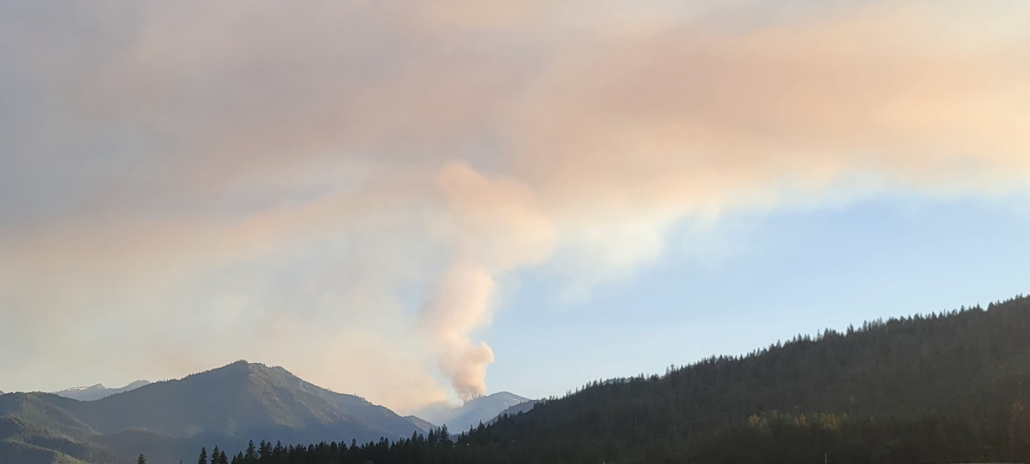
Shelly Fire became active in the evening.
South Fork Salt BAER Update7624 07 06 2024
Related Incident: South Fork and Salt Fires Burned Area Emergency Response
Publication Type: News
INCIWEB UPDATE
SOUTH FORK AND SALT BAER ASSESSMENTS
JULY 6, 2024
This is the final InciWeb update for the Department of the Interior (DOI) and USDA Forest Service (USFS) Burned Area Emergency Response (BAER) assessment team. The team completed BAER plans for submission to the Bureau of Indian Affairs, and two (initial and interim) funding emergency treatment requests for submission to the USFS Southwest Regional Office.
Yesterday, the team provided a close-out briefing to the Mescalero Apache Tribe and today, a close-out briefing to the Lincoln National Forest on respective treatments and cost estimates. These close-out meetings both discussed treatments that will cross jurisdictional boundaries to be effective. This morning, the team presented their findings to a room full of cooperating authorities like the village, city, counties, state, Federal Emergency Management Agency (FEMA), and US Army Corps of Engineers (USACE). While the land managers, BIA and USFS, wait for funding approvals, the group will begin organizing around treatments on non-federal lands downstream from the burned areas.
Additional information on understanding the BAER program, process and other post-fire information is posted on the South Fork and Salt BAER InciWeb page found at: Nmmea South Fork And Salt Fires Burned Area Emergency Response Information | InciWeb (wildfire.gov).
For further information on the status of the BAER reports, plans and implementation of the proposed treatments, please contact:
- Mescalero Apache Tribe, Elaina LaPaz, elapaz@mescaleroapachetribe.com
- Lincoln National Forest, Amanda Fry, amanda.fry@usda.gov
BAER SAFETY MESSAGE: Everyone near and downstream from the burned areas should remain alert and stay updated on weather conditions that may result in heavy rains and increased water runoff. Flash flooding may occur quickly during heavy rain events--be prepared to act. Current weather and emergency notifications can be found at the National Weather Service website: www.weather.gov/abq/.
###
Fire Mitigation in Beulah 07 06 2024
Related Incident: Oak Ridge Fire
Publication Type: Announcement
We'd like to applaud all of the home and landowners in the community who have proactively been inquiring about mitigation! Preparing your home for wildfire and reducing wildfire risks in the Home Ignition Zone helps keep firefighters safe, but also increases the likelihood that your house does not burn!
Beulah residents can haul and pile their slash to the slash pile site at the Beulah Fire Protection and Ambulance District Station daily. These sites are for the removal of woody debris, including limbs and branches, (no commercial operators allowed).
It’s never too late to mitigate!
If you need more information on how to mitigate your property, check out, https://csfs.colostate.edu/.../2021_CSFS_HIZGuide_Web.pdf...
Firefighters on the #oakridgefire_co are assisting with community mitigation efforts through chipping operations along firelines. Chipping reduces the amount of debris and large ground litter and reduces ground fuels that help fire spread.
Sheering Fire Update 07 06 2024
Related Incident: 2024- Sheering Fire
Publication Type: News
CURRENT SITUATION: The eastern flank of the fire adjacent to Forest Road 3N01 experienced more active yesterday. Hand crews burned from Forest Road 3N01 back into the fire, widening the containment line and burning out some of the remaining interior fuel pockets. Most of the fire continues to experience low to moderate fire behavior and a slow rate of spread. Dozer line has been completed on the southeast side of the fire. Hand crews working from the west side of the fire were able to connect the line from Forest Road 2N29 and out of Bourland Creek to the dozer line. The fire is still hung up in the Lost Creek drainage with little forward progression. The high numbers of standing dead trees remains a threat to fire lines and fire fighters.
Today crews will continue to hold and improve the fire lines, including felling snags and mopping up to widen the lines. The plan also includes putting in hose lays along Forest Road 2N85 and the southern dozer line to further secure these areas.
BACKGROUND: The Sheering Fire started on June 24, 2024, at approximately 7:19 pm. It was one of several fires that resulted from an unusual lightning event that moved through the area that day. In addition to the Sheering Fire, two fires were ignited in the Clavey River drainage which is where the 2013 Rim Fire started. Because of their location and the known potential for those fires to become large quickly, they were the top
priority for fire resources, including air support. They were fully contained and then additional resources moved to the Sheering Fire which has burned with low to moderate intensity and a slow rate of spread over the past 10 days.
The Sheering Fire has been a full suppression fire from the beginning. It is located within the 2013 Rim Fire and has many old standing dead trees which makes it a higher risk for firefighters trying to put in handline and mop up into the burn area. Public and firefighter safety is the Forest Service’s highest priority. Because of this fire’s location, its slow rate of spread and its mostly low intensity fire behavior, fire managers have been able to utilize existing roads and natural features for containment lines in several locations around the fire perimeter, protecting both fire fighters and resources in the area.
ACREAGE: 485
PERCENT CONTAINED: 12%
TOTAL PERSONNEL: 148
Fire Resources include: 6 Hand Crews, 1 Helicopter, 4 Engines, 1 Dozer, 1 Water Tender
For more information contact Forest Public Affairs Officer, Benjamin Cossel at 209-288-6261 or at Benjamin.Cossel@usda.gov.
Forest Fire Restrictions on the Los Padres National Forest 07 06 2024
Related Incident: 2024 Lake Fire
Publication Type: Closures
Current Fire Restrictions
Forest Order 05-07-00-24-11 Fire Use Restrictions: Effective June 29, 2024 - January 31, 2025
In response to the increasing potential for wildland fire starts, Los Padres National Forest officials announced that fire restrictions will be implemented throughout the Forest effective June 29. These restrictions will affect the use of campfires, stoves, smoking materials, and internal combustion engines, and will remain in effect until January 31, 2025.
- No open fires, campfires or charcoal fires will be permitted outside of developed recreation sites or designated Campfire Use Sites (list attached), even with a valid California Campfire Permit. Lanterns and portable stoves using gas, jellied petroleum or pressurized liquid fuel will be permitted, but only with a valid California Campfire Permit, which can be obtained free-of-charge at this website. Forest visitors must clear all flammable material for five feet in all directions from their camp stove, have a shovel available, and ensure that a responsible person always attends the stove during use.
- Smoking is prohibited, except within an enclosed vehicle, building, or a designated Campfire Use Site, or while stopped in an area at least three feet in diameter that is barren or cleared of all flammable material.
- Internal combustion engines may be operated only on roads or designated trails. This restriction is in effect year-round. Please make sure your engine is tuned, operating properly, and has an approved spark arrester.
- Fireworks – even the “safe and sane” variety – are not permitted at any time or in any location within the Forest.
- Discharging a firearm is prohibited within Los Padres National Forest except while legally hunting or at Winchester Canyon Gun Club and Ojai Valley Gun Club which operate under special use authority.
For a list of Developed Recreation Sites and Campfire Use Sites in Los Padres National Forest, or further information regarding Fire-Safe Camping, visit www.fs.usda.gov/lpnf or contact the U.S. Forest Service district office nearest you.
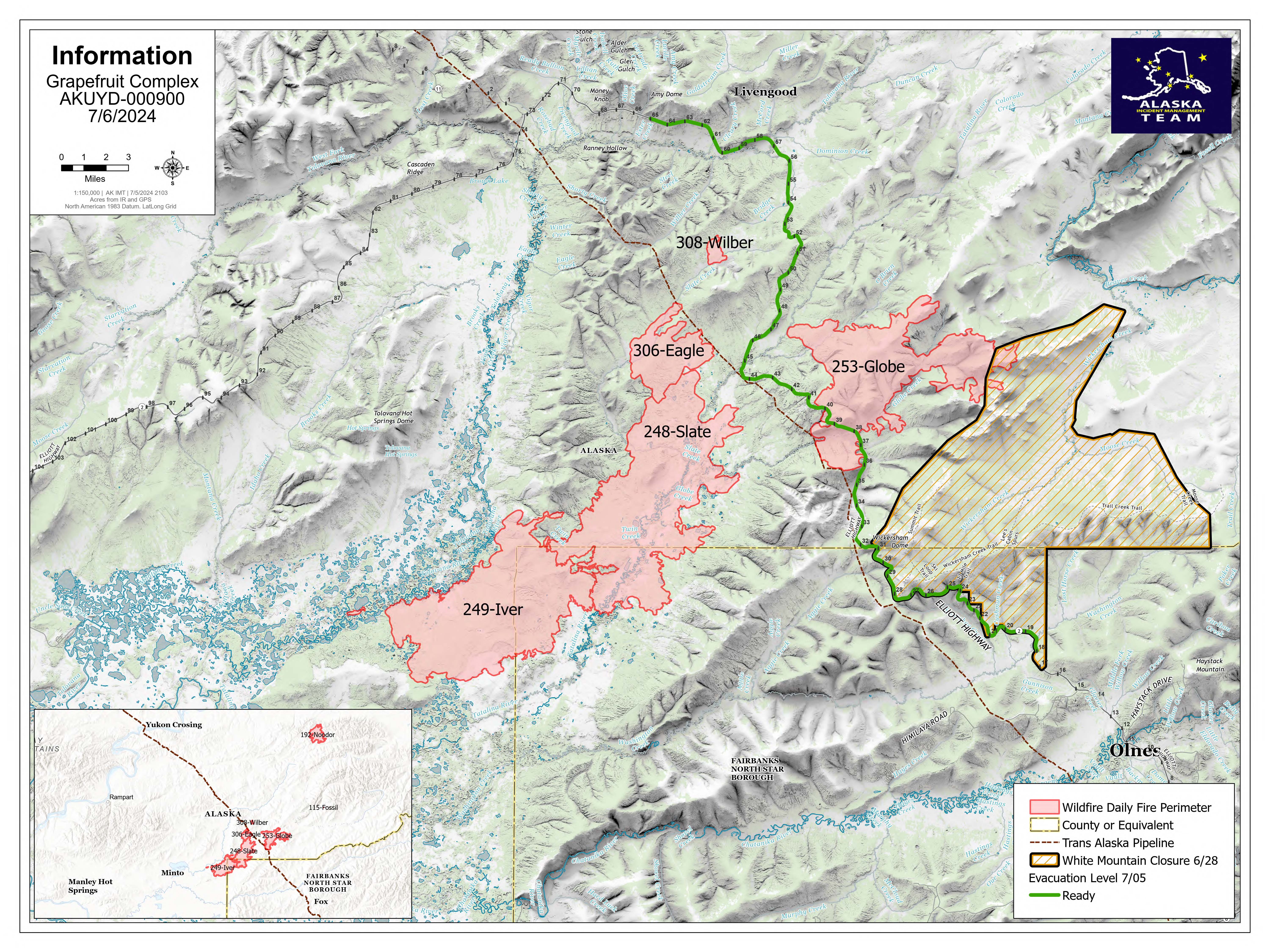
Grapefruit Complex Daily Update 07 06 2024
Related Incident: Grapefruit Complex
Publication Type: News
Grapefruit Complex
Daily Update: Saturday, July 6th, 2024
Alaska Incident Management Team 3
Incident Commander- Peter Butteri
Location: 40 Miles north of Fairbanks
Complex Acres: 87,434
Continued widespread rain over the fire has minimized spread. Fire officials are working with the local units to effectively prepare and map structures at risk and critical resources for current and future defense. Protecting structures is the primary focus and objective of firefighters assigned to the Grapefruit Complex, with nearly half of the work complete. Evacuations were adjusted Friday due to the change in fire behavior and weather. A 90% chance of rain with 10-20 mph southwest winds is predicted for Saturday.
The Grapefruit Complex includes the Globe Fire (#253), Iver Fire (#249), Eagle Fire (#306), Wilber Fire (#308), Noodor Fire (#192), and Fossil Fire (#115). Firefighters are working to prevent fire spread toward property and structures in the area. Crews are also focused on protecting the Elliott Highway, Trans-Alaska Pipeline, Native Allotments, and public and private structures, as well as minimizing impacts to fish habitat along the Tatalina and Tolovana river corridors. Fire activity includes creeping and smoldering.
Evacuations: Evacuation levels were reduced on Friday (July 5th). The current levels are represented as:
Ready (Green): Elliot Hwy MM 18-65 / Set (Yellow): None currently. / Go (red): None currently.
Smoke: Rain has improved air quality. However, smoke may still be present on the highway mixed with fog. Please exercise caution and patience when driving. Turn on your headlights to help ensure the safety of firefighters and flaggers working in the area.
Road access: The Elliott Highway is open. Expect significant delays between Mile Posts 25-65 if fire activity increases. Firefighters are working out of Wickersham Dome trailhead with increased traffic and heavy equipment exiting and entering the area around Mile Post 28. Alaska Department of Transportation & Public Facilities contracted workers and a pilot car are helping keep the flow of traffic open. Check https://511.alaska.gov/ for road updates.
Temporary Flight Restriction: No TFRs are in place over the fire area.
Closures: The Bureau of Land Management (BLM) Eastern Interior Field Office closed the western portion of the White Mountains National Recreation Area surrounding the Wickersham Dome Trailhead at mile 28 Elliott Highway. The closure is in effect until Sept. 1, unless the BLM determines the area is safe for public use at an earlier time.

Shelly Fire Daily UpdateAM07062024 07 06 2024
Related Incident: Shelly Fire
Publication Type: News
INCIDENT FACTS:
Incident Start Date: July 3, 2024 Incident Start Time: 1:27pm Incident Type: Wildland Fire
Cause: Under Investigation Incident Location: Marble Mountain Wilderness
Size: 487 Acres Containment: 0%
A Public Meeting is Scheduled for tonight July 6th at 7:00 PM
Quartz Valley Indian Reservation Gym, 9040 Sniktaw Lane, Fort Jones
Current Situation: Yesterday, four Interagency Hotshot Crews worked along the Pacific Crest Trail constructing additional handline. Southeast of the fire crews scouted for additional containment options. From the south, firefighters accessed the area of Mule Bridge and continued north identifying access to the fire. The fire grew 42 acres in the late afternoon in the Pointers Gulch area, and helicopters were used to limit the fire growth.
Today, on the northern side of the fire crews will continue to work along the Pacific Crest Trail as well as seek opportunities to work directly at the fire’s edge where possible using aircraft to support their efforts. On the southern side, firefighters will access the area in the Mule Bridge area and continue north to Pointers Gulch providing access to the fire. North and South contingency groups have been established and will be coordinating with CAL FIRE.
Weather:
A Red Flag Warning is in effect for this afternoon and evening with a Fire Weather Watch for Sunday afternoon. Gusty northwest winds will develop along ridges this afternoon and evening then shift to the northeast tonight remaining breezy at ridge level but diminishing elsewhere. Today’s weather is forecast to be hot and dry with a maximum temperature of 90-100 degrees in the valley and minimum relative humidity of 8-11%.
Closures:
An official closure area around the Shelly Fire went into effect on July 4th. Hikers are not permitted in the area and will be asked to leave. For details and a map of the closure area, please visit https://www.fs.usda.gov/Internet/FSE_DOCUMENTS/fseprd1187463.pdf.
Fire Restrictions:
Forest fire restrictions also went into effect on July 4th. Campfires and stove fires are restricted to those developed areas listed in the forest order located at https://www.fs.usda.gov/alerts/klamath/alerts-notices/?aid=88596. Smoking, welding, and operating an internal combustion engine also has restrictions in place.
Control line improvements continue around the Lockett Fire 07 06 2024
Related Incident:
Publication Type: News
The Lockett Fire experienced moderate growth Thursday evening as winds pushed the fire to 69 acres within the containment perimeter. Fire crews took advantage of calm winds in the area on Friday, constructing line close around the Lockett Fire to moderate spread potential as hot and dry conditions are expected to persist through the weekend.
Light winds today will allow firefighters to continue making improvements to strengthen interior containment lines and patrol and evaluate needs in the Lockett Fire area. Crews will also continue working with archaeologists to provide protection to sensitive sites of cultural significance within the planning area.
Hot and dry conditions with light winds will continue through the weekend with no precipitation expected into next week. The fire is expected to experience slow-to-moderate growth. When conditions are safe to do so, fire managers plan to manage the Lockett Fire in a confine and contain strategy within a predetermined area. Fire will be applied to the landscape through hand ignitions along the forest road and dozer containment lines and aerial ignitions within the perimeter. The intended outcome of this fire includes encouraging the growth of native plants, increasing species diversity in the understory, and the restoration of wildlife habitat.
When ignitions begin, a 3-mile section of the Arizona Trail south of Grandview Tower will be temporarily rerouted along Forest Road 310.
Smoke may be visible from various forest roads in and around the vicinity, as well as along State Route 64/East Rim Drive within Grand Canyon National Park.
Managing naturally caused wildfires across the landscape is a very effective tool in restoring the forest to a healthier condition, and these efforts align with the Forest Service's 10-year Wildfire Crisis Strategy, which aims to increase the use of fire on the landscape as well as other treatments to improve forest resiliency for generations to come.
Additional information can be found on the Kaibab NF website, X, Facebook, Flickr, or by calling the local ranger stations.
Basin Fire Daily Update for July 6 2024 07 06 2024
Related Incident: Basin Fire
Publication Type: News
Basin Fire Update
Saturday, July 6, 2024
Public Fire Information: 559-468-6809, 8 A.M. to 8 P.M.
Media Information: 559-492.9967
Email: 2024.basin@firenet.gov
Facebook: @SierraNF
PEOPLE AND EQUIPMENT: 1,305 personnel, 32 crews, 71 engines, 14 helicopters, and 16 dozers.
CURRENT SITUATION: The Basin Fire is at 14,020 acres. Containment is 46%. The heat wave continues to impact the fire by drying vegetation and producing heat stress challenges for fire personnel. With fire activity reduced, a few resources are beginning to be released, are shifting to suppression repair, or held in reserve to respond to any new fire activity. Ground resources and two helicopters were released last night to the Lake Fire in the Los Padres National Forest.
• Eastern perimeter: The eastern side of the fire continues to remain within the constructed lines, however rollout of burning material may still occur. This area is being monitored by aircraft and firefighters in the area.
• Southern perimeter: Containment line has been secured along the South Fork of the Kings River and the area is being monitored. Crews are working on suppression repair and backhauling trash.
• Western perimeter: Crews have boxed in the fire with a combination of dozer line and retardant. Firefighters continue to patrol and increase the depth of containment lines.
• Northern perimeter: Crews succeeded in constructing a helicopter landing area west of the Dinkey Creek drainage despite steep, rugged terrain. This major accomplishment is enabling firefighters to build fire line in an area that was previously inaccessible. Crews were flown in yesterday and are working on fire-line construction.
• Contingency Lines: North of the fire perimeter, along the PG&E lines and vicinity, work is continuing on contingency fire lines using crews, dozers, masticators, and feller-bunchers, to block the fire if it starts moving north.
SHAVER LAKE FIREWORKS: Today is the Shaver Lake fireworks show. If you are visiting - or an area resident - you will have lots of company! Thousands of people are expected at the lake this evening and drive times will be very long on Highway 168 on the way to Shaver Lake. It may take up to 3 hours to leave the Forest after the show. Plan for a slow drive home and have plenty of water along in your car.
Please support our firefighters by respecting the Sierra National Forest closure area. Keep in mind that no fireworks are permitted on federal land and that the vegetation is very dry. Stay hydrated and enjoy your weekend!
An EXCESSIVE HEAT WARNING through next week continues to affect the fire with high temperatures, drying vegetation, and little relief at night. Temperatures are forecast to reach as high as 108 today and relative humidity remains low. Winds are forecast to remain low, from the west at 8-12 mph and gusts to 15. The National Weather Service has reported that “A heat wave this intense, this long, has not been experienced in this region in 20 years.” Cooling stations have been set up at the fire command post and on the fire line to help reduce the cumulative effects of heat stress on firefighters.
The Basin Fire started on June 26, 2024, and the cause is currently under investigation. Currently, the fire is at 2000-4500 elevation, northeast of Pine Flat Lake, west of the Spanish Mountain, south of Black Rock Rd (11S012) and north of the South Fork of the Kings River.
Updates are posted on InciWeb: https://inciweb.wildfire.gov/incident-information/casnf-basin-fire.
EVACUATIONS: The mandatory evacuation order remains in place for Fresno County zones K29, K30, K31, K40, K41 & K166. Evacuation warnings are in effect for zones K61 & K76. Check the Fresno County Evacuation map: Evacuation zones will begin to change as fire containment increases.
https://www.arcgis.com/apps/webappviewer/index.html?id=e7d6006a016a444db8b210ac4d2eb5cf
FIRE FATIGUE: This area's history of stressful wildfires means that some community members are experiencing worry, anxiety, "disaster fatigue," and other reactions that are normal responses to these abnormal events. Fresno County Behavioral Health has resources available at https://www.fresnocountyca.gov/Departments/Behavioral-Health/Care-Services/Disaster-Fatigue.
FOREST CLOSURE and FIRE RESTRICTIONS for the Basin Fire: To ensure the safety of the public and our firefighters, The Sierra National Forest has issued a Temporary Partial Forest Closure for the Basin Fire area. Effective June 30, 2024, the closure will remain in effect until July 30, 2024. We urge the public to respect all closure signs and barriers and to avoid the area to prevent any potential accidents or interference with firefighting efforts.
Sierra National Forest has also implemented temporary fire restrictions prohibiting campfires, welding, and smoking in non-developed campsites.
Visit https://www.fs.usda.gov/sierra for more information or call the Sierra National Forest (559) 297-0706 during business hours for questions.
FOREST VISITORS: This Fire may affect YOU!!!
•The following campgrounds are CLOSED due to this fire: Bear Wallow Campground, Black Rock Campground, Gravel Flat Group Campground, Kirch Flat Campground, Kirch Flat Group Campground, Oak Flat Campground, Ross Crossing Campground, Sawmill Flat Campground, Bretz Mill Campground.
•Check https://www.fs.usda.gov/sierra for the Forest closure area map. Roads & trails in this area are CLOSED.
• This is NOT a good year for a campfire outside of any of the open campgrounds. Please see the message above to contact the Sierra National Forest.
•AIR QUALITY is being impacted by Basin Fire smoke. Please check the air quality for your destination at www.airnow.gov. Today’s Smoke Outlook is available.
• Fireworks are NOT permitted on Federal land
• Camp safely and keep hydrated this holiday week!
Wet weather continues today as Idaho Team 1 IMT 3 prepares to take command of McDonald Fire 07 06 2024
Related Incident: McDonald Fire
Publication Type: News
Size: 172,236
Personnel: 80
Start Date: June 8, 2024
Cause: Lightning
FAIRBANKS, Alaska – Overnight the weather stations in the area of the McDonald Fire received a half inch of rain. This, along with the precipitation and cool temperatures on Friday, moderated fire behavior and there was minimal perimeter growth.
Today, Idaho Team 1 IMT 3 will shadow the BLM Alaska Fire Service Type 3 organization to prepare to take over the fire on Sunday. This allows the incoming team to get a feel for all the good work that has been completed by the previous team and ensures there is a smooth transition as firefighters continue to secure and protect the values at risk.
In the 5 Mile Creek Area, crews will continue with mop-up operations to secure the fire’s edge. Firefighters will also continue to monitor fire behavior for any potential spotting or flanking beyond the perimeter. Lookouts are being staffed by a wildland fire module to provide information to crews on the ground. With the wind and rain in the forecast again today, operations will be weather and safety dependent.
Weather: Wet and windy conditions continue through the weekend. There is a high chance of wetting rains today as a front moves across the area. This will likely slow fire growth, although smoldering is expected to continue under the canopy and in areas that receive less precipitation. Temperatures are forecast to be in the 50s to 60s.
Burn Permits: The Division of Forestry and Fire Protection has lifted the Burn Permit Suspensions for Fairbanks, Salcha, Delta, Tok, and Railbelt areas. Small and Large Scale Permits are required. Burning is allowed today. The fire danger in these areas is MODERATE. Please check https://dnr.alaska.gov/burn/fireareas or call the burn permit hotline for the Fairbanks Area Forestry at (907) 451-2631 for the most current updates.
Air Quality: The cool, wet weather significantly moderated fire behavior and smoke production on Friday. There is still some lingering smoke Saturday in the Tanana River Valley. It will be a bit drier and windier, but the overall pattern will stay cool and wet through the weekend and into next week. With the decrease in smoke, the air quality is expected to remain GOOD. Fairbanks Memorial Hospital (1650 Cowles St.) has clean-air rooms available for people impacted by smoke open from 9 a.m. to 9 p.m. Find information on how to protect yourself from wildfire smoke at the Smoke Management page on https://akfireinfo.com/smoke-management/.
Evacuation Notices: A Level 2: SET evacuation notice is in effect for the approximately 20 cabins near the fire’s southeastern edge west of the Tanana River. The communities east of the Tanana River are in READY status, including the Johnson Road neighborhoods, Canaday, Harding Lake, Salcha, the lower Salcha River, Hollies Acres, and south to Birch Lake. Find more information and an interactive map of these areas on the Fairbanks North Star Borough Emergency Services website.
Temporary Flight Restriction: The temporary flight restriction (TFR) has been adjusted based on public input to give float plane access to Harding Lake. Be aware helicopter operations to support the fire still continue in the area. Visit tfr.faa.gov for more information.
-BLM-
Bureau of Land Management, Alaska Fire Service, P.O. Box 35005, 1541 Gaffney Road, Fort Wainwright, AK 99703
Need public domain imagery to complement news coverage of the BLM Alaska Fire Service in Alaska?
Visit our Flickr channel! Learn more at www.blm.gov/AlaskaFireService, and on Facebook and Twitter.
The Bureau of Land Management Alaska Fire Service (AFS) located at Fort Wainwright, Alaska, provides wildland fire suppression services for over 240 million acres of Department of the Interior and Native Corporation Lands in Alaska. In addition, AFS has other statewide responsibilities that include: interpretation of fire management policy; oversight of the BLM Alaska Aviation program; fuels management projects; and operating and maintaining advanced communication and computer systems such as the Alaska Lightning Detection System. AFS also maintains a National Incident Support Cache with a $18.1 million inventory. The Alaska Fire Service provides wildland fire suppression services for America’s “Last Frontier” on an interagency basis with the State of Alaska Department of Natural Resources, USDA Forest Service, National Park Service, Bureau of Indian Affairs, U.S. Fish and Wildlife Service, and the U.S. Military i