
Smoke Outlook Eastern Oregon 07 20 2024
Related Incident: Lone Rock Fire
Publication Type: News
Smoke Outlook 7/20 - 7/21
Eastern Oregon (Falls Fire)
Special Statement
A Heat advisory will be in effect today through Monday as expected temperatures are expected to be above 100 degrees. An Air Quality Alert has been issued by the Oregon Department of Environmental Quality for Grant, Harney and Malheur Counties.
Fire
There are multiple fires effecting the forecast area. The Falls Fire is currently 117,020 acres and is 10% contained. The Lone Rock Fire is 83,922 acres and is 40% contained. The Durkee Fire is 24,269 acres and the Battle Mountain Complex is 3,750 acres. Hot, dry conditions will continue to result in active fire and continued smoke production across the area as multiple fires continue to burn.
Smoke
Smoke from multiple fires will continue to impact the area as high pressure results with hot dry conditions across the area. The most impacted areas are those communities south of active fires and this is expected again today. Burns continues to see UNHEALTHY air quality, south of the Falls Fire and John Day is expected to be UNHEALTHY for SENSITIVE GROUPS. Conditions will improve late afternoon as winds will clear the smoke and MODERATE conditions are expected in most locations. Sunday and Monday similar conditions are expected, however as fires remains active and the heat increases its recommended that people try to find places with air conditioning, stay hydrated and take extra precautions if you work or spend time outside.
Black Fire Daily Update 07 20 2024
Related Incident: Black Fire
Publication Type: News
Acres: 11,162
Start Date: July 11, 2024
Location: South of Roosevelt Lake on the edge of the Superstition Wilderness
Cause: Lightning
Personnel: 404
Fuels: Tall Grass and Brush
Containment: 51%
Resources: 11 Crews | 13 Engines | 2 Helicopters | 2 Bulldozers | 3 Water Tenders
Highlights: Gila County Division of Emergency Management along with the Gila County Sheriff’s Office have moved all evacuations orders that are in effect for the Black Fire to “READY” status. The following Tonto National Forest recreation sites will remain administratively closed to support fire personnel: Grapevine Campground, and Frazier Horse Campground and Group Site. Gila County would like to remind residents to prepare now; Gila County retains a culture of readiness year-round. For more information about Ready, Set, Go and to sign up for alert notifications visit https://ein.az.gov/ready-set-go.
Tonto National Monument plans to open for normal summer business hours on Wednesday, July 24 at 8 a.m.
Operations: Firefighters have made progress strengthening and improving containment along the northeast flank from Forest Road 341 south to the Black Brush Ranch to prevent growth during critical fire weather. Crews and heavy equipment will continue to patrol the fire, mop up remaining hot spots near control lines; and start to repair and rehabilitate areas where suppression actions were taken, and clear hazardous snags and debris along roadways in and around the fire area. Light smoke may be visible at times, as interior fuels continue to smolder. As a reminder, residents and recreationists need to utilize caution while driving on the roads in and around the Black Fire as firefighters and equipment are traveling to and from the fire on state highways and roads.
Weather: Overnight relative humidity recoveries have been around 50% and temperatures in the low to mid-80s. Afternoon temperatures are forecasted to be from 102-107 degrees with afternoon humidity readings dropping to around 20%. We will once again see scattered afternoon and early evening thunderstorms today, but the probability is low that rain will fall within the fire perimeter. The main concern with these storms will be the gusty and erratic outflow winds. Chances of rain increase Sunday and Monday as the overall flow becomes more favorable for storm development.
Smoke: Individuals who are sensitive to smoke or have conditions aggravated by smoke are encouraged to take precautionary measures. An interactive smoke map at https://fire.airnow.gov/ allows you to zoom into your area to see the latest smoke conditions.
Closures: The Tonto National Forest has issued a closure for land surrounding the Black Fire. 03-12-00-24-31_Black Fire_Closure_Order. Additionally, the Tonto National Monument is closed. National Park Service Alerts.
Evacuations: For current evacuation information please call Gila County Emergency Management at 928-910-4009 EXT 1 or visit the Gila County Government Facebook page at - https://www.facebook.com/gilacountygovernment/
Safety: The health and safety of firefighters and the public are always the highest priority. Please avoid the area while crews conduct fire suppression operations. Citizens are urged to sign up for the Gila and Maricopa County Emergency Notification System. To learn more about the Arizona Emergency Information Network visit: https://ein.az.gov/ready-set-go.
Settings - change map background and toggle additional layers
Filter - control incident types displayed on map.
Zoom to your location
Reset map zoom and position
Could not determine your location.
Show Legend
 Wildfire
 Prescribed Fire
 Burned Area
Response
Burned Area
Response Other
Other
Ore Fire
Unit Information
Incident Contacts
Buckhorn Fire Update Saturday 72024 07 20 2024
Related Incident: Buckhorn Fire
Publication Type: News
Buckhorn Fire: 1,006 acres
Start Date: July 10, 2024
Cause: Suspected lightning
Fuels: Timber, Brush, Understory
Containment: 44%
Resources: 165
Location: Malay Gap Area, San Carlos Reservation
Update: Saturday, July 20, 2024 Central West Zone Type Three IMT To Command Buckhorn Fire
Highlight: The Central West Zone Type Three Incident Management Team has taken command of the Buckhorn Fire as of 0600 today. Thanks to the Southwest Area Complex Incident Management Team Two for their hard work.
Overview: Yesterday, on the Buckhorn Fire, firefighters began to construct handline to connect two dozer lines near Bull Ridge. Crews worked for as long as safely possible until lightning forced them to withdraw. Firefighters also responded to several new starts along Route 8, toward Point of Pines, and quickly extinguished the fires. Today, firefighters will work to continue to construct handlines and monitor weather conditions. Defensive burning operations are still planned, but crews must wait until the fuel conditions are more favorable.
Weather: Yesterday brought a little rain to the Buckhorn Fire. Rain fell heaviest on the eastern side of the fire with amounts between one-tenth and one-quarter of an inch. The storms also brought a lot of lightning, which forced crews to disengage from the fire for their safety. There is a 70 percent chance of storms today, with temperatures in the 80s and west/southwest winds of 15 to 20 miles per hour.
Reminder: Stage 1 Fire Restrictions remain in place on the San Carlos Apache Reservation. Due to extreme drought, increasing temperatures, and no rain predicted soon, the potential of catastrophic wildfire remains high. This restriction is for the protection of public health, safety, property, and natural resources. No burn permits will be issued at this time. For more information call Fire Prevention (928) 475-2326 Ext: 352, 321 or (928) 961-0515 or email wsteele@forestry.scat-nsn.gov Closures: There is an area closure in place around the Buckhorn Fire.
Closures are being adjusted based on fire activity for public and firefighter safety. Please monitor the San Carlos Apache Tribe Facebook Page for updated information. (Link Below) Smoke: Smoke-sensitive individuals and people with respiratory problems or heart disease are encouraged to take precautionary measures. Air quality information is available at https://www.airnow.gov/
Fire Information: 928-588-4033 from 8 A.M. to 8 P.M.
2024.buckhorn@firenet.Gov
Facebook: https://www.facebook.com/SCATFORESTRY
Inciweb: https://inciweb.wildfire.gov/incident-information/azsca-buckhorn-fire
Nowhi ni’nlt’eego anlsih
2024 SQF Lightning Smoke Outlook 07 20 2024
Related Incident: 2024 SQF Lightning
Publication Type: News
Fire
The Long Fire has potential for large growth under strong afternoon winds. It is burning in steep terrain with no recorded fire or treatment history. No fire spread is expected on the Acorn and Packsaddle Fires. The Trout Fire is expected to have comparatively moderate fire behavior. Expect smoke production from both fires.
Smoke
Slight change in the smoke patterns today. Smoke will return to mostly pooling on the lower Owens Valley in the overnight hours. Models indicate that smoke will continue to travel down the Highway 190 corridor bringing smoke in the late evening/early morning hours to the foothill communities. At this time, it is not anticipated to be in as high concentrations as Friday night.
Blacktail Canyon Fire Evening Update 07 20 2024
Related Incident: Blacktail Canyon
Publication Type: News
BLACKTAIL CANYON FIRE
Incident Commander J. Willoughby
Location: southeast of Butte, MT between Interstate 90 and Highway 2
Start Date: 7/19/2024
Cause: Unknown
Size: estimated at 150 acres
Resources on Site: 8 air tankers, 6 helicopters, 3 engines, 1 type 1 “hotshot” hand crew, 1 type 2 hand crew
KEY MESSAGES:
The Butte-Silver Bow Law Enforcement Department has issued an evacuation warning for Blacktail Canyon Road southeast of Homestake Road and Homestake Road east of Blacktail Canyon Road. This warning means residents should be prepared to evacuate but are not yet under an evacuation order.
The Blacktail Canyon fire is a developing situation and has the potential to change rapidly. Updates will be posted to the Beaverhead-Deerlodge NF Facebook page. In addition, an Inciweb page will be shared once established.
CURRENT STATUS:
Seven Large Air Tankers (LAT) and a Very Large Air Tanker (VLAT) dropped fire retardant during the afternoon and evening hours. Six helicopters provided aerial support through water bucket drops to help cool hot spots. Engines crews, a 20-person crew, and other firefighters assisted on the ground.
Working in cooperation with the Butte-Silver Bow community officials, fire managers have identified and prioritized critical values at risk, focusing available resources and current efforts on the protection of the private structures in the Blacktail Canyon and Homestake Road areas. Local Fire Department engines provided structure protection in these areas. Additional resources, including three type 2 hand crews, have been ordered. As they arrive, fire managers and agency officials will collaborate to utilize resources to protect the prioritized values.
Firefighters are currently scouting for areas to access the fire and safe anchor points for fireline construction. Protecting life and property and ensuring firefighter safety are of the utmost importance. The fire moved to the south and east today.
WEATHER AND FIRE BEHAVIOR
Fire behavior was active throughout the afternoon and evening hours, with single tree and group torching and short-range spotting observed. Aerial observations included several actively burning spots.
Hot, dry conditions will persist over the weekend and into much of next week. Relative humidity recovery overnight will be poor, especially at upper elevations. Winds will be from the northeast at 5-15 mph. There is a slight chance for afternoon thunderstorms over the weekend.
Shelly Fire Morning Update 07 20 2024
Related Incident: Shelly Fire
Publication Type: News
Location: Siskiyou County, CA Start Date: Wednesday July 3, 2024 at 1:27 PM
Size: 15,464 acres Percent Contained: 21%
Cause: Under Investigation Personnel: 2,701
CURRENT SITUATION:
Personnel continue concentrated efforts to expand containment around the Shelly Fire. This includes engaging in mop-up operations along much of the north and east perimeters from upper Kidder Creek down to the Patterson Creek drainage areas, and further developing fire lines along the south and west perimeters in the vicinity of the Pacific Crest Trail.
In the northwest near Mill Creek and in the south along the Right Hand North Fork Salmon River, where the fire remains a bit more active, crews have continued to go direct with air and ground resources. Along the east side, crews are beginning to work on suppression repair efforts in and around affected communities.
Drivers in the area should remain alert for fire personnel and heavy equipment on or near the roadways, as both day and night crews continue working toward full containment.
WEATHER:
Increasingly hot and dry conditions with southwest terrain-driven winds will continue into next week, with a slight chance of isolated thunderstorms this evening.
EVACUATIONS:
For current evacuation status, visit www.facebook.com/SiskiyouCountySheriff and www.facebook.com/SiskiyouCountyOES. Additional evacuation information and a map can be found on the Genasys site at https://protect.genasys.com/search?z=14&latlon=41.550694%2C-122.905589.
SHELTERS:
RV Dry Camping/Parking West Webb St. and Hoag St. in Montague
Please note, at this time, there are no extra services (sewage/water/power hookups). This is currently set up for DRY camping.
Animal shelters are available at the following location(s) for those who have pets and animals displaced due to the Shelly Fire:
Dog Evacuation Shelter:
Rescue Ranch Yreka, 2216 East Oberlin Road, Yreka CA 96097
Contact: John Golay 541-698-7526
Livestock Animal Evacuation Shelter (horses, pigs, sheep, goats, birds):
Siskiyou Golden Fair, 1712 Fairlane Road, Yreka, CA 96097
Contact: Tom Taylor 530-340-1038
Cat Evacuation Shelter:
Siskiyou Golden Fair - Armory Building, 1712 Fairlane Road, Yreka, CA 96097
Contact: Becca 530-340-0656
CLOSURES:
An official forest closure around the Shelly Fire went into effect on July 4th. Hikers are not permitted and will be asked to leave the area. For details and a map of the closure area, please visit
https://www.fs.usda.gov/Internet/FSE_DOCUMENTS/fseprd1187463.pdf.
FIRE RESTRICTIONS:
Forest fire restrictions are currently in effect. Campfires and stove fires are restricted to those developed areas listed in the forest order at https://www.fs.usda.gov/alerts/klamath/alerts-notices/?aid=88596. Smoking, welding, and operating an internal combustion engine also have restrictions in place.
Pacific Crest Trail Information: https://www.pcta.org/discover-the-trail/closures
Speirs Fire Daily Update 07 20 2024
Related Incident: Speirs Fire
Publication Type: News
The weather conditions have been a big help to firefighters on the Speirs Fire the last few days. Cloud cover, which is favorable weather, and scattered showers helped, along with night recovery, which is when the relative humidity goes up and the temperature goes down. This slowed the fire spread to help crews on the line. Weather conditions are expected to turn dry and hot for the weekend and into the beginning of next week.
Fire containment has increased significantly since the Incident Management Team arrived, with the help of many resources. Firefighter safety remains a top priority. To ensure crews stay safe, spike camps were set up closer to the fire line. Now crews will have access to resources they need without having to hike in and out each day. Crews have been able to create five helipad locations around the fire’s perimeter. With the addition of the helipads, new crews arriving can be flown directly to the line and provide a much safer way to evacuate any injured crew members if the need should arise. Today, heavy equipment will be added to assist with creating line.
The initial attack team and the team currently suppressing the fire have done excellent work in establishing strategic boundary areas to mitigate the future spread of the fire. That, along with wetter conditions, have given
firefighters the upper hand. While good progress continues, the work is not done yet.
Closures:
Being on or within the following campgrounds, roads, and trails are prohibited on the Flaming Gorge Ranger District on the Ashley National Forest: Firefighters Memorial Campground, Greendale Group Campsite, Forest Service Road (FSR) 610, FSR 689, Lowline trail FST103 its junction with the Pipe Creek Trail, FST 003. Forest Service Trail 003 from the beginning at the junction with FST 103 to the junction of Forest Service Trail 004 and Forest Service Trail 004 to Greens Draw Road 049. For more information on existing closures, please visit the Ashely National Forest website at https://www.fs.usda.gov/alerts/ashley/alerts-notices
Temporary Flight Restrictions (TFR): A TFR is in effect over the Speirs Fire area. Using uncrewed aerial systems (UAS)/drones is illegal within the TFR.
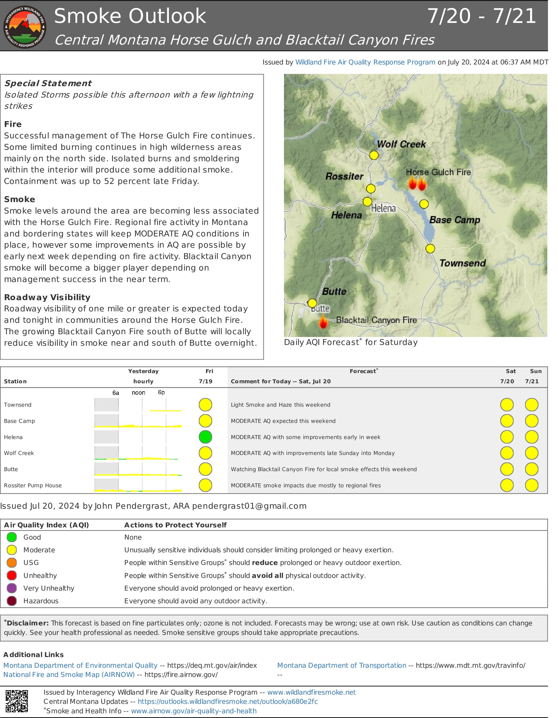
Horse Gulch Smoke Outlook 07 20 2024
Related Incident: Horse Gulch Fire
Publication Type: News
Special Statement
Isolated Storms possible this afternoon with a few lightning strikes
Fire
Successful management of The Horse Gulch Fire continues. Some limited burning continues in high wilderness areas mainly on the north side. Isolated burns and smoldering within the interior will produce some additional smoke. Containment was up to 52 percent late Friday.
Smoke
Smoke levels around the area are becoming less associated with the Horse Gulch Fire. Regional fire activity in Montana and bordering states will keep MODERATE AQ conditions in place, however some improvements in AQ are possible by early next week depending on fire activity. Blacktail Canyon smoke will become a bigger player depending on management success in the near term.
Roadway Visibility
Roadway visibility of one mile or greater is expected today and tonight in communities around the Horse Gulch Fire. The growing Blacktail Canyon Fire south of Butte will locally reduce visibility in smoke near and south of Butte overnight.
Settings - change map background and toggle additional layers
Filter - control incident types displayed on map.
Zoom to your location
Reset map zoom and position
Could not determine your location.
Show Legend
- Wildfire
- Prescribed Fire
- Burned Area
Response
- Other