
Battle Mountain Complex Evening Update 07 21 2024
Related Incident: Battle Mountain Complex
Publication Type: News
Community Gets Update from Battle Mountain Complex
UKIAH, Ore. – ODF Incident Management Team 3 along with federal and local officials held a community meeting at the Ukiah Community Park. About 100 people attended and heard updates about both fires and evacuation levels.
Tyler McCarty, ODF IMT 3 Incident Commander, said “the number of fires on the landscape stretch from the southwest corner of the state clear up here in northeast Oregon, and, as a result, left the region with little to no firefighting resources.” He did say, though, that “crews and equipment continue to arrive for this complex and that should make a positive impact moving forward.”
The Battle Mountain Complex consists of the 3,642-acre North Fork Owens Fire and the 2,766-acre Snake Fire. Crews made good progress getting line around the North Fork Owens fire. The Snake fire had aggressive growth on the south side where it crossed the North Fork John Day River. Ground crews, dozers and helicopters worked to stop forward progress and establish line, but winds were pushing the line. Overnight, crews will strengthen line where they can and monitor both fires for any spot fires.
Closures: A road closure remains in effect for Highway 395, between mile posts 50 through 90, beginning 35 miles South of Pilot Rock.
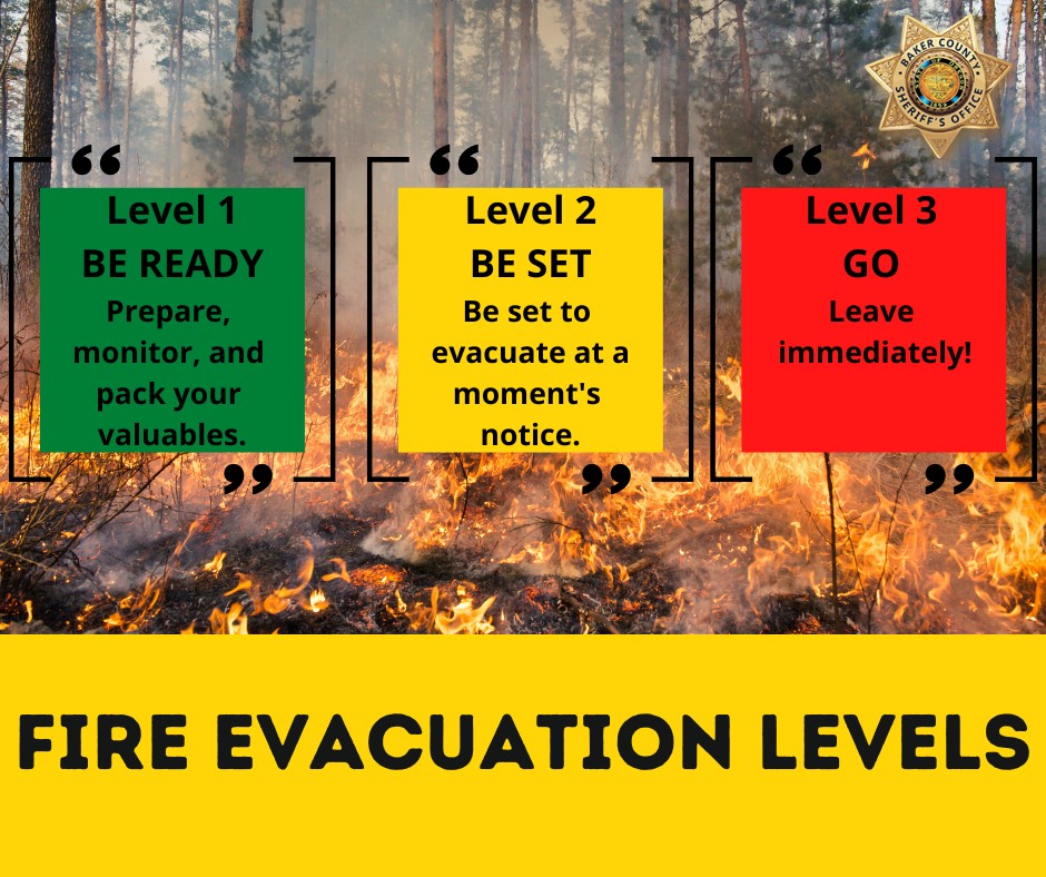
Evacuations: Level 1 (Be Ready) , Level 2 (Be Set) and Level 3 (Go Now) evacuations are in effect. For updated evacuation information, visit the Umatilla County Sheriff's Office Facebook page, www.facebook.com/UmatillaCountySheriff, or sign up for the Umatilla County Emergency Alert System at https://member.everbridge.net/index/2590041373147145.
ODF’s Northeast Oregon District is currently in Extreme (red) fire danger and there are additional restrictions for industrial forest operations on lands protected by the Oregon Department of Forestry. Current fire restrictions can be found at www.bmidc.org or by calling the Northeast Oregon Fire Prevention line: (541) 975-3027.
For current area fire info, go to http://bluemountainfireinfo.blogspot.com/ or ODF NEO Facebook: www.facebook.com/oregondeptofforestryNEO/. To report a fire, call Blue Mountain Interagency Dispatch at (541) 963-7171 or dial 9-1-1.
Boneyard Fire Evening Update 07 20 2024
Related Incident: Boneyard Fire
Publication Type: News
Oregon Department of Forestry Incident Management Team 1 sent to Boneyard Fire
MONUMENT, Ore. – Oregon Department of Forestry Incident Management Team 1, Incident Commander Joe Hessel, received a briefing this afternoon from local resources as transfer of the fire begins.
Incident Management Team 1 was recently deployed to the Salt Creek Fire, had mandatory rest, and is now assuming command of the Boneyard fire within 24 hours’ notice of the need.
Settings - change map background and toggle additional layers
Filter - control incident types displayed on map.
Zoom to your location
Reset map zoom and position
Could not determine your location.
Show Legend
 Wildfire
 Prescribed Fire
 Burned Area
Response
Burned Area
Response Other
Other
Pincer Two Fire
Unit Information
Incident Contacts
Settings - change map background and toggle additional layers
Filter - control incident types displayed on map.
Zoom to your location
Reset map zoom and position
Could not determine your location.
Show Legend
- Wildfire
- Prescribed Fire
- Burned Area
Response
- Other
Miners Complex Fires
Unit Information
Incident Contacts
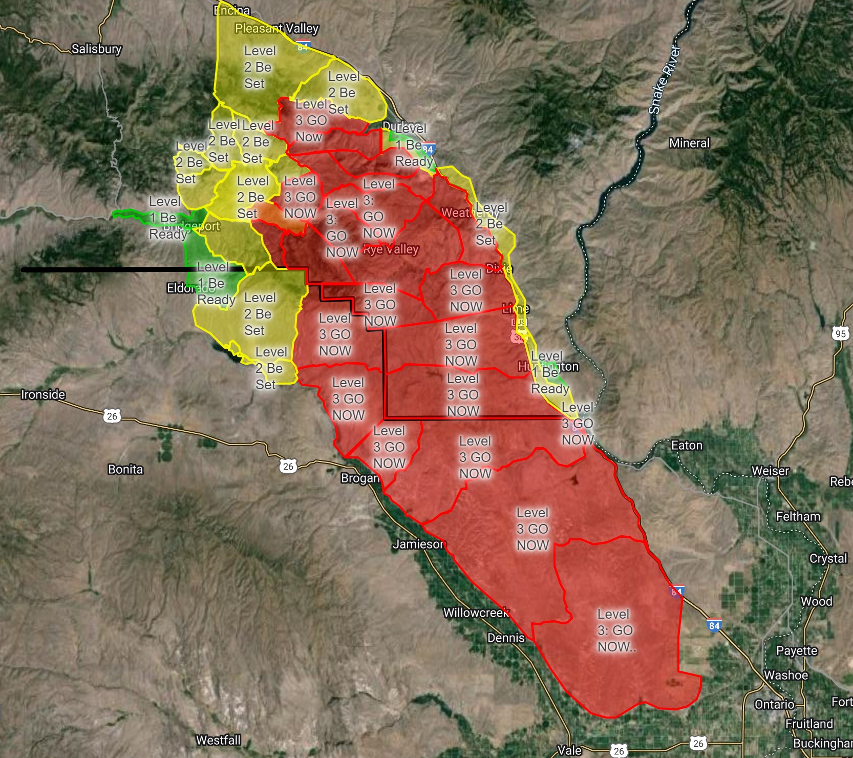
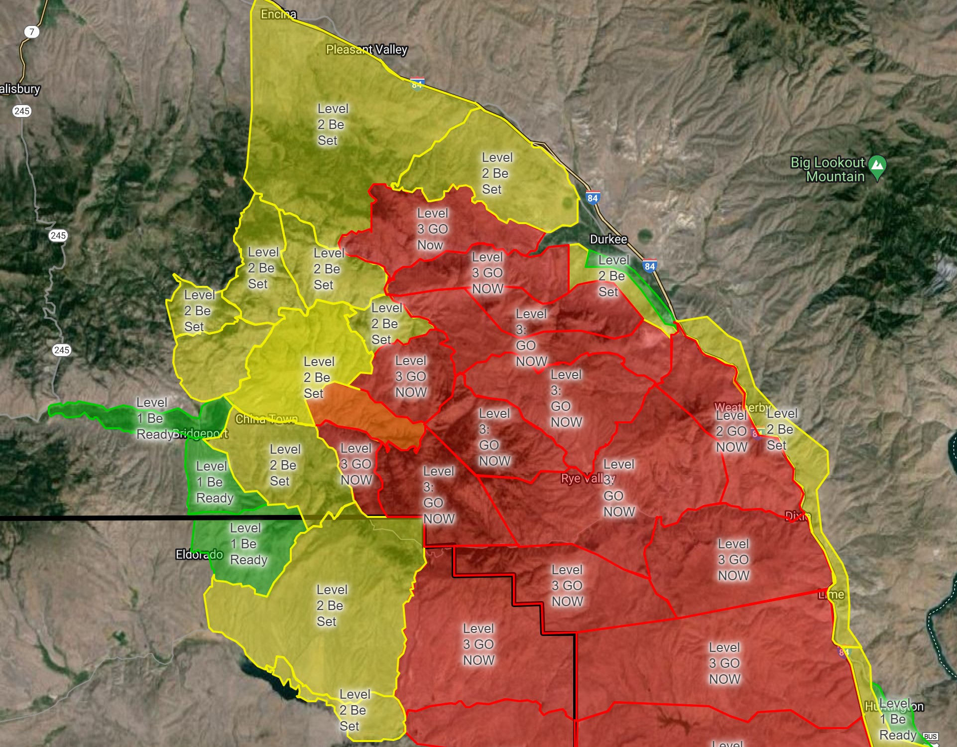
Baker County Evacuation Update 302 pm 07 20 2024
Related Incident: Durkee Fire
Publication Type: Announcement
EVACUATION LEVELS UPDATE (7/20/24 3:02 P.M.): The Durkee Fire has continued to advance south. A Level 3 (GO NOW) evacuation has been extended into rural areas of Willowcreek and Vale in Malheur County. Huntington remains at a Level 1 (BE READY). Maps in this post have been updated.
July 20 2024 Evening Update Fork Fire 07 21 2024
Related Incident:
Publication Type: News
Evening Update
Date: 7-20-2024 Time: 8:00 pm
Size: 330 acres Start Date & Time: 7-19-24 3:23 pm
Containment: 30% Cause: Under Investigation
Total Personnel: 181 Location: Heaton Flats (near East Fork Rd)
Firefighter Injuries: 2 Structures Threatened: 0
Current Situation:
The Fork Fire started at 3:23 p.m. near East Fork Rd. The fire is 330 acres with 0% containment and is burning in steep terrain in chaparral. The wildfire is burning in a northeasterly direction towards the Sheep Mountain Wilderness. Over 350 personnel are committed to this incident including the Angeles National Forest, LA County Fire Department, Ventura County Fire Department, Cal Fire, California Highway Patrol, and LA County Sheriff's Department. Recreationist have been evacuated from the East Fork of the San Gabriel Canyon. The San Gabriel Canyon is closed to all forest visitors. For current wildfire information follow Angeles National Forest:
- Website: fs.usda.gov/angeles
- Facebook: https://www.facebook.com/angelesnationalforest
- X (formally known as Twitter): https://x.com/Angeles_NF
- InciWeb: https://inciweb.wildfire.gov/incident-information/caanf-fork-fire
Evacuations:
Recreationists have been evacuated from the East Fork of the San Gabriel River. Residents have not been evacuated at this time.
Closures:
- Highway 39
- East Fork Road
- Glendora Ridge Road
- Glendora Mountain Road
Fire Restriction:
The current fire danger level on Angeles National Forest is HIGH. "Know Before You Go"--to always check fire restrictions before each and every visit, as restrictions can change at any time with little to no notice: https://www.fs.usda.gov/detail/angeles/home/?cid=FSBDEV3_027721
Watch Lone Rock Fire Community Meeting Saturday July 20 2024 07 21 2024
Related Incident: Lone Rock Fire
Publication Type: Announcement
Lone Rock Fire Community Meeting
Saturday July 20, 2024 in Fossil, Oregon at 6:00 PM
Wheeler County Sheriff's Office
Gilliam County Sheriff's Office
U.S. Forest Service - Umatilla National Forest
Morrow County Sheriff's Office
Oregon Department of Forestry Central Oregon District
Gilliam County Fire Services - Oregon
Grant County Oregon
Settings - change map background and toggle additional layers
Filter - control incident types displayed on map.
Zoom to your location
Reset map zoom and position
Could not determine your location.
Show Legend
- Wildfire
- Prescribed Fire
- Burned Area
Response
- Other
Swawilla Fire
Unit Information
Incident Contacts
Blacktail Canyon Evening Update07 21 2024
Related Incident: Blacktail Canyon
Publication Type: News
BLACKTAIL CANYON FIRE - EVENING UPDATE
Incident Commander J. Willoughby
Location: southeast of Butte, MT between Interstate 90 and Highway 2
Start Date: 7/19/2024
Cause: Undetermined
Size: estimated at 68 acres
Resources on Site: 3 engines, 3 type 1 “hotshot” hand crews, 4 type 2 hand crews
Total Personnel Assigned: 154
KEY MESSAGES:
The Butte-Silver Bow Law Enforcement Department has issued an evacuation warning for Blacktail Canyon Road southeast of Homestake Road, Homestake Road east of Blacktail Canyon Road and Passmore Canyon. This warning means residents should be prepared to evacuate but are not yet under an evacuation order.
CURRENT STATUS/PLANNED ACTIONS:
Aircraft, including a Very Large Air Tanker (VLAT), helicopters with water bucket drops, and water “scooper” airplanes, kept the fire within its current footprint today.
Three “hotshot” crews will begin constructing direct fireline (immediately adjacent to the fire’s edge) by removing fuels and mitigating “snag” hazards, tying into existing control features in the Beaver Pond Meadows area. Fire leadership will conduct aerial observation through a reconnaissance flight prior to implementing fireline construction. Several other crews will continue to assess critical values at risk in the Blacktail Canyon, Passmore Canyon, and Toll Mountain areas.
The fire is burning in large amounts of dead and down lodgepole pine trees, posing additional hazards and affecting on-the-ground progress. Ensuring firefighter safety and protecting life and property are of the utmost importance during any incident.
Working in cooperation with the Butte-Silver Bow officials, fire managers have identified and prioritized critical values at risk, focusing available resources and current efforts on the protection of the private structures in the Blacktail Canyon, Homestake Road and Passmore Canyon areas. (Local Fire Department engines provided structure assessments in these areas. As additional resources arrive, fire managers and agency officials will collaborate to utilize resources to protect the prioritized values.
WEATHER AND FIRE BEHAVIOR
Fire behavior was moderate, with torching, backing and creeping observed. Hot, dry conditions will persist over the weekend and into much of next week. Relative humidity recovery overnight will be poor, especially at upper elevations. Winds will be from the northeast at 5-15 mph. There is a slight chance for afternoon thunderstorms over the weekend.
Update Weather Finally Arrives 07 20 2024
Related Incident: Mestenas Canyon Fire
Publication Type: News
Rain tamped down much of the behavior on the Mestenas Canyon Fire, where the perimeter has grown to 477 acres with 15% containment.
Steep terrain and outflow winds from nearby thunderstorms are driving the fire’s spread on its north and east sides. To contain the fire, crews are nearby using indirect methods by reducing fuels along the northern portion of Forest Road 312N before the fire front arrives. Flames have already reached the road’s south side, where crews previously worked. Containment lines are holding along that stretch of road.
Fire behavior has otherwise been minimal on the southern and western sides. Crews have been able to begin building containment line directly along the fire perimeter.
There are no evacuations, but oil and gas infrastructure, archeological sites, dispersed camping areas and inholdings may be threatened if the fire grows beyond planned control lines.
The lightning-caused Mestenas Canyon Fire was first reported July 11. It is in the canyon of the same name, about 14 miles southwest of Dulce, N.M., and two miles north of Highway 64, where smoke may cause limited visibility to drivers.
The public can keep updated on the fire by visiting InciWeb or calling a public information officer at 505-216-6793.