
Pioneer and Easy Fires Update 07 20 2024
Related Incident:
Publication Type: News
Pioneer and Easy Fires Update for July 20, 2024
Incident Commander Jeff Dimke
Complex Incident Management Team Northwest 12
541-861-5808, staffed 8 a.m. to 8 p.m. 2024.pioneer@firenet.gov
A new fire start was spotted in the aftermath of the lightning storm that moved through the Methow Valley on July 17. NW Team 12 has taken command of the Kitling Peak Fire and will manage it along with the Pioneer and Easy Fires. Last night, helitack firefighters were sent to the Kitling Peak Fire via helicopter, to attempt access on the ground to extinguish the fire while it remains very small (approximately 1 acre). The Pioneer Fire remains the top priority as additional resources become available. NW Team 3 arrived and will spend the day today working alongside NW Team 12. They will transition to take over management of the fires as NW Team 12 completes their 14-day assignment and returns home.
Pioneer Fire: Size: 26,407 acres | Cause: Human-caused | Containment: 14% | Total personnel: 783
Firefighters made progress strengthening and improving containment lines around structures in Stehekin and are continuing to explore all possible options to protect Stehekin in cooperation with local residents. Yesterday, firefighters used a tactical firing operation near Hunts Bluff to remove available fuels with lower intensity burning, putting only necessary fire on the ground to carefully complete the operation. Crews also performed mop-up in previously burned areas around Moore Point. A heavy helicopter lost a water bucket over the fire yesterday due to a mechanical hook failure. Helicopters are using water bucket drops today at the northern perimeter of the fire near Hunts Bluff, and firefighters are prepared to initiate additional limited firing operations if needed to secure portions of the fire edge.
Easy Fire: Size: 150 acres | Cause: Lightning | Containment: 0% | Total personnel: 20
There was little movement on the Easy Fire on Friday. Firefighters identified two avalanche chutes on either side of the fire that can be prepared and used as fire control lines. Additional resources will be required to complete this work, which are currently unavailable due to other wildfires across the state. Fire managers will work to free up these crews in the coming days and complete these control lines.
Safety and Closures: The National Park Service-North Cascades has expanded their list of closures: https://www.nps.gov/noca/planyourvisit/fire-closures.htm. The Okanogan-Wenatchee National Forest has a closure order in place for much of the fire area: https://bit.ly/PioneerClosure. Camp fires are also prohibited. There is a Temporary Flight Restriction (TFR) in place over the fire: https://tfr.faa.gov/save_pages/detail_4_6779.html. Unauthorized drone activity is prohibited under the TFR.
Evacuations: Level 1, 2 and 3 evacuation levels remain in effect around the Pioneer Fire. There are no evacuations in place for the Easy Fire. Please visit https://t.ly/QoH9w for more information.
Weather and Smoke: The National Weather Service issued an Excessive Heat Warning until 8 PM Monday: https://bit.ly/46byTZw. Fire activity could increase and become erratic as the higher temperatures and increased instability move into the area over the weekend. The air quality outlook can be found at: https://bit.ly/PioneerFireSmoke. Learn more about smoke at http://wasmoke.blogspot.com/. The fire marshal issued fire danger ratings and restrictions: https://t.ly/WLBds.
Cougar Creek Fire Update07 20 2024
Related Incident: Cougar Creek Fire
Publication Type: News
Cougar Creek Fire Update for Saturday July 20, 2024
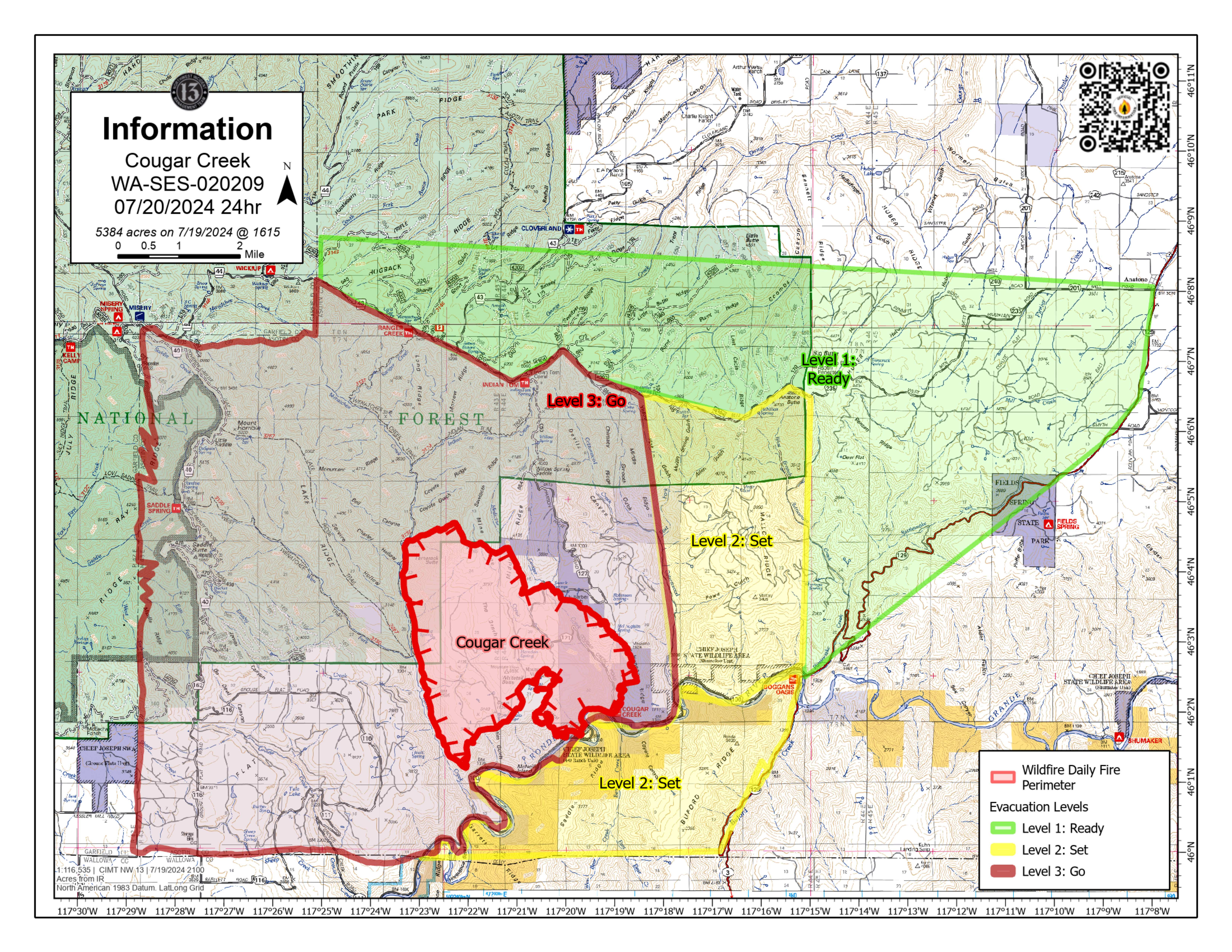
Clarkston, WA – The Cougar Creek Fire continues to burn in rugged rangeland in Southeast Washington along the Washington – Oregon border, approximately 40 miles SW of Clarkston, WA. County, district, state, and federal crews are engaged in full suppression tactics to minimize the number of acres burned. The fire is now at 7% containment.
In addition to the crews engaging the fire on the ground, multiple aviation resources are playing an integral role in establishing containment lines. Some of the air resources assisting the incident include helicopters, Large Air Tankers (LATs), and Very Large Air Tankers (VLATs). To date, more than 24,000 gallons of retardant have been dropped, primarily on the northern edge of the fire where fire activity is more active. Helicopters and fixed wing aircraft work in close coordination with ground crews to perform high precision drops of water or fire retardant. Working in tandem, they can slow fire growth and extinguish hot spots.
Incident objectives include protecting assets such as timber, rangeland, and livestock by minimizing fire growth and acres burned. On the northeast corner, crews are building containment lines and strategically burning out fingers of vegetation ahead of the main fire. To the west, structure prep and protection is taking place and crews are working diligently to prevent the fire from crossing Wenatchee Creek. To the south, crews are controlling and monitoring fire spread along the Grande Ronde River system.
WEATHER: Weather will remain hot and dry well into next week. Temperatures will continue in the triple digits with relative humidity in the low teens. There will be some minor weather relief after the middle of next week, but it will still be hot with temperatures in the 80s. RH will remain in the teens through next week. With the exception of some afternoon diurnal wind gusts, winds will remain relatively light. This weekend’s extreme heat and dry conditions will continue to produce an environment that will support very active fire behavior.
SAFETY: There are evacuations in effect, please see the evacuation notice from Asotin County Sheriff and Asotin County Emergency Management. The county has established an animal shelter at the Asotin County Fairgrounds.
SMOKE: Smoke will continue to be moderate across the area near Clarkston, WA for the next few days. If you are “unusually sensitive” to particle pollution, consider reducing your activity level or shorten the amount of time you are active outdoors. Smoke levels can change rapidly depending on weather. Check current conditions on AirNow.gov.
CLOSURES: The Grande Ronde Road is closed from Troy, Oregon to the Highway 129 junction. Forest officials are temporarily closing the southeastern portion of the Pomeroy Ranger District located in Asotin County and small portions of Garfield County and Wallowa County on Umatilla National Forest Lands to ensure public safety. This temporary closure will also ensure the safety of firefighters engaged in operations to suppress the Cougar Creek Fire. Fire managers are continually assessing resource needs based on fire spread and behavior. The cause of the fire is currently under investigation.
Lone Rock Fire Update July 20 2024 07 20 2024
Related Incident: Lone Rock Fire
Publication Type: News
LONE ROCK FIRE UPDATE July 20, 2024
Location: Lonerock, Oregon to west of Hwy 207 | Size: 83,922 acres | Containment: 40% Cause: Under Investigation
Start Date: July 13, 2024 | Total Personnel: 800
InciWeb: https://inciweb.wildfire.gov/incident-information/orprd-lone-rock-fire
Fire Information Line: 541-208-4369 | Email: 2024.0404rvlonerock@firenet.gov
There will be a community meeting today at 6:00 p.m. at the Grade School Gym located at 392 Main Street, Fossil, Ore. The meeting will also be available on the Lone Rock Fire Facebook page. The community is encouraged to attend and receive firsthand updates from the unified command of the Northwest (NW) Team 2 and the Oregon State Fire Marshal (OSFM) Red Team.
Condon, Oregon — The Lone Rock Fire is being managed under a full suppression strategy by the unified command of the Northwest (NW) Team 2 and Oregon State Fire Marshal (OSFM) Red Team.
Yesterday’s Activities: On Friday, extreme fire behavior began earlier in the day compared to recent days. This extended the duration of extreme fire behavior and the hot, dry conditions led to fire spread to the south. OSFM resources, including several enhanced taskforces, provided structure protection to dwellings south of Forest Road 25 to Spray, Ore. An east-northeast wind component pushed the fires' southern perimeter south towards Spray, Ore. Throughout the day, firefighting conditions were extremely hazardous, forcing firefighters to temporarily disengage for their safety. Three more taskforces arrived yesterday bringing the total count of structural taskforces to 11. Firefighters were able to contain multiple areas that slopped over containment features along Forest Service Road 21. OSFM task forces worked in Lonerock, Ore. to continue mop-up operations and hold the progress that was made through the week. The northern area of the fire continues to hold and firefighters remain on the scene to ensure the fire's perimeter remains secure.
Today’s Activities: Fire behavior is elevated to critical levels with the Red Flag Warning with fire conditions near or above record highs. The dry fuels and forecasted weather are favorable for extreme fire behavior which will be resistant to control. Firefighters are focused on fundamental firefighting practices which include prioritizing safety, having backup plans, and using effective tactics to ensure a high probability of success. This pattern of extreme fire conditions is anticipated to amplify over the weekend. Thus, continued extreme fire behavior and additional fire growth is expected. Operations Section Chief Sonny Caldwell stated, “we are experiencing fire behavior that is exceeding all of our current modeling data.” However, firefighters and the entire incident management team remain agile and focused on protecting human life and minimizing fire spread with strategy and tactics likely to ensure a high probability of success. Today, OSFM taskforces will have a significant presence in and around the town of Spray, Ore. They will also integrate with their wildland partners to work the southwest side of the fire and southeast side of the fire from Winlock Road to the Morrow County OHV Park. Two additional taskforces will be sent to the
Boneyard Fire to provide day and night coverage to the Monument community as an additional incident management team is expected to arrive on that fire later today.
Three helicopters are assigned to this incident and will concentrate on dropping water over the southern area to support and enhance the efforts of the firefighters on the ground.
Evacuations:
• Level-3 Evacuations – GO NOW! Level-3 Evacuate immediately for the following areas:
o Gilliam County: residences South of Lonerock. Visit Gilliam County Sheriff's Office Facebook page o Wheeler County: North of Hwy 207 and East of Hwy 19 from Service Creek to the Winlock Rd,
Including City of Spray, Ore. and from Alder Creek along Hwy 19-2 07 E to Hwy 2 07 at the Heppner junction, Hwy 207 N to mile post 39. Alder Creek North to the Windlock intersection to include city of Spray.
o Morrow County: from the West County Line along Buttermilk Canyon to HWY 207, Mile Post 10 South of Hardman to the South Morrow County line. The Red Cross will be setting up a temporary shelter at the Heppner Elementary School. For more information on evacuations, visit Morrow County Sheriff's Office Facebook page.
• Level-2 Emergency Alert – GET SET! Level-2 Be set to evacuate at a moment’s notice for the following areas:
o Gilliam County: residences North of Lonerock.
o Wheeler County: the area 5 miles South of Hwy 207, East of Service Creek and West of Bologna
Rd/Balm Creek and the area extending 5 miles west of Hwy 19 south of Rowe Cr and Northwest of Hwy 207.
• Level 1: Be Ready - Prepare to Evacuate. Level 1 Be ready to evacuate in the following areas:
o Wheeler County: the area East of Richmond/Tamarack Cr and West of Misery Mtn/Johnson Cr. 5-7 mi South of Hwy 207
Shelters:
• An evacuation center has been set up at the Wheeler High School (600 E B Street, Fossil, Ore.). A large animal shelter is available at the County Fairgrounds (720 E 3rd Street in Fossil, Ore.).
- The Red Cross will be setting up a temporary shelter at the Heppner Elementary School.
Memorial Hall in Condon was previously identified as an evacuation shelter. Since no evacuees have checked
in, Memorial Hall is now being utilized by firefighters working the Lone Rock Fire and is no longer available for evacuees. If evacuees have questions or concerns, they can call non-emergent dispatch at 541-384-2080.
Weather: A Red Flag Warning for hot, dry, and unstable conditions is in place from 11:00 a.m. Saturday through 11:00 p.m. Sunday with a dry cold front passage Sunday evening.
An offshore flow under a ridge of high pressure will result in breezy east to northeast winds over the weekend. It will also be hot, dry, and unstable with critical fire weather conditions expected through Sunday evening. A cold front late Sunday afternoon into Sunday evening will bring the potential for virga showers and a small threat (up to 10% chance) for isolated thunderstorms. Any showers or thunderstorms that develop will bring a threat for gusty and erratic winds Sunday evening into Monday. Cooler temperatures are expected next week with a return of northwest winds.
Smoke Information: Visit https://fire.airnow.gov/ for local air quality information.
Flight Restrictions: A Temporary Flight Restriction (TFR) is in place above the Lone Rock Fire area. If you fly, we can’t. Unauthorized drone flights (UAS) pose serious risks to firefighter and public safety and the effectiveness of wildfire suppression operations. Aerial firefighting is suspended when unauthorized UAS are in the area, allowing wildfires to grow larger.
###
Blacktail Canyon Fire Morning Update 07 20 2024
Related Incident: Blacktail Canyon
Publication Type: News
Incident Commander J. Willoughby
Location: southeast of Butte, MT between Interstate 90 and Highway 2
Start Date: 7/19/2024
Cause: Unknown
Size: estimated at 96 acres (overnight infrared mapping flight)
Resources on Site: 3 engines, 1 type 1 “hotshot” hand crew, 2 type 2 hand crews
Resources on Order: 3 type 1 “hotshot” crews, 2 type 2 hand crews, 3 large helicopters, Scoopers
KEY MESSAGES:
The Butte-Silver Bow Law Enforcement Department has issued an evacuation warning for Blacktail Canyon Road southeast of Homestake Road and Homestake Road east of Blacktail Canyon Road. This warning means residents should be prepared to evacuate but are not yet under an evacuation order.
CURRENT STATUS:
Seven Large Air Tankers (LAT) and a Very Large Air Tanker (VLAT) dropped fire retardant during the afternoon and evening hours yesterday. Six helicopters provided aerial support through water bucket drops to help cool hot spots. Engines crews, a 20-person crew, and other firefighters assisted on the ground. Additional large helicopters, water “scooper” airplanes and additional crews are on order and should arrive today.
Firefighters are currently scouting for areas to access the fire and to locate safe anchor points for fireline construction. Hotshot crews are currently looking for opportunities to safely construct fireline, tying into existing roads/trails, to prevent progression of the fire northward. Helicopter rappelers will work to construct a helispot at the heel of the fire on the top of Blacktail Canyon. Other crews will continue to assess critical values at risk in the Blacktail Canyon, Passmore Canyon, and Toll Mountain areas. The fire is burning in large amounts of dead and down lodgepole pine trees, creating additional hazards and affecting progress.
Working in cooperation with the Butte-Silver Bow community officials, fire managers have identified and prioritized critical values at risk, focusing available resources and current efforts on the protection of the private structures in the Blacktail Canyon and Homestake Road areas. Local Fire Department engines provided structure protection in these areas. Additional resources, including three type 2 hand crews, have been ordered. As they arrive, fire managers and agency officials will collaborate to utilize resources to protect the prioritized values.
WEATHER AND FIRE BEHAVIOR
Fire behavior was active yesterday, with single tree and group torching and short-range spotting observed. Fire crews remaining on-site overnight experienced dry lightning and gusty outflow winds until the early morning hours. Fire behavior is expected to be similar to yesterday. Hot, dry conditions will persist over the weekend and into much of next week. Relative humidity recovery overnight will be poor, especially at upper elevations. Winds will be from the northeast at 5-15 mph. There is a slight chance for afternoon thunderstorms over the weekend.
Deadman Fire Daily Update 07 20 2024
Related Incident:
Publication Type: News
Video Update: https://fb.watch/ts9Z6maOs1/
Deadman, McGhee, Prairie, and Four Mile Fires
Bureau of Land Management Montana-Dakotas State Office
Montana Department of Natural Resources and Conservation
Fire Information 406-924-3831 2024.Deadman@firenet.gov
https://inciweb.wildfire.gov/incident-information/mtmts-deadman-fire www.facebook.com/RosebudCountyDisasterAndEmergencyServices
Saturday, July 20, 2024
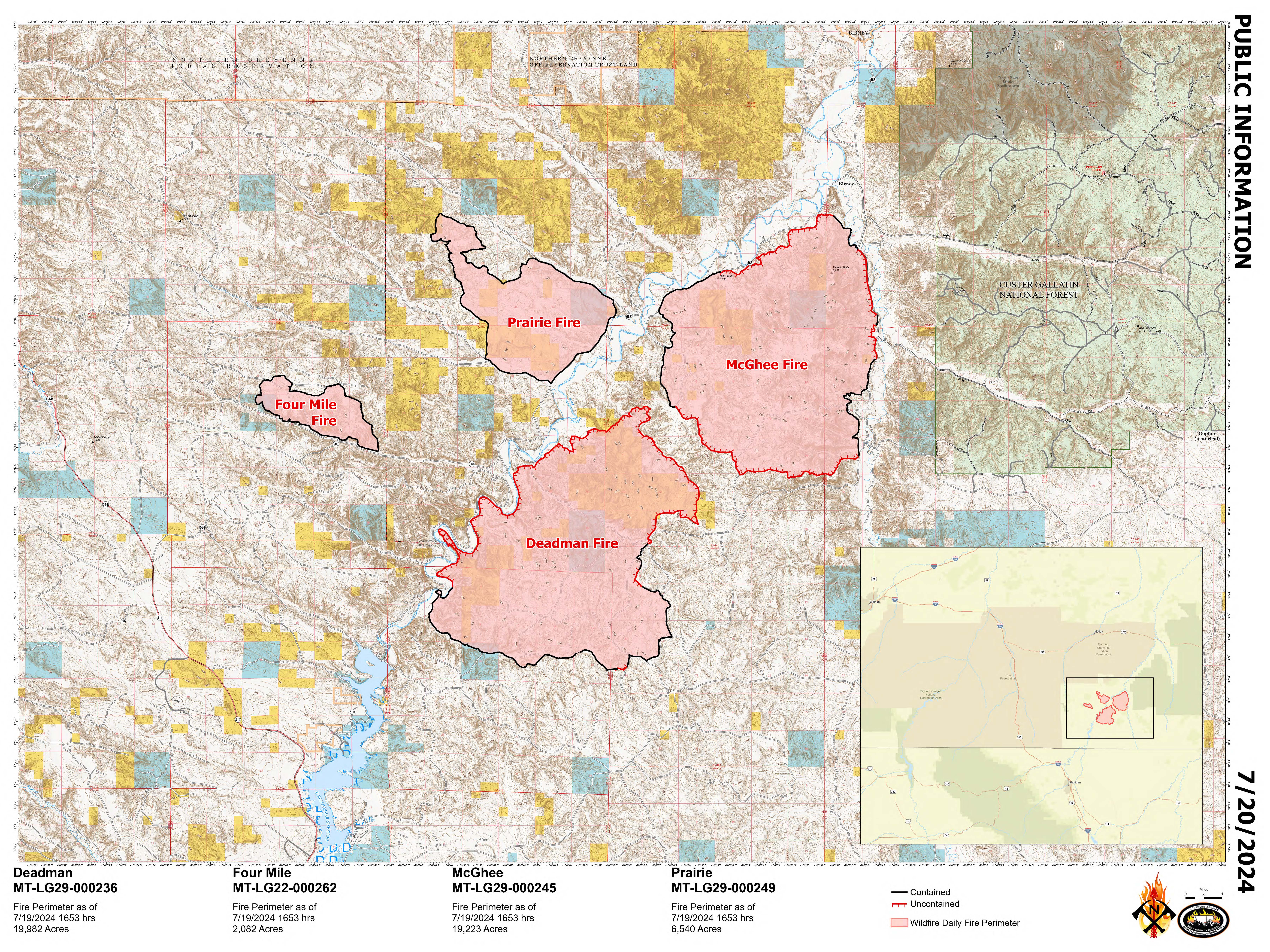
Northern Rockies Team 3, Incident Commander Mike Behrens
Location: South of Birney, Montana and north of Tongue River Reservoir in Rosebud and Big Horn Counties
Start Date: 7/12 and 7/13/2024
Cause: Lightning
Size: Deadman: 19,982 McGhee: 19,223 Prairie: 6,540 Four Mile: 2,082
Completion/Containment: Deadman: 35% McGhee: 9% Prairie: 100% Four Mile: 100%
KEY MESSAGE
By this morning, crews had completed burnout operations along the Tongue River Road and the Hanging Woman Creek Road on the McGhee Fire. Yesterday, firefighters also mopped up around the residences where they had conducted protective burnouts along the east flank. On the southwest corner of the Deadman Fire, the fire crossed into dry grass on the west side of the Tongue River during Thursday night’s thunderstorm, and the smokejumper module with the support of engines was able to confine it to an eight-acre area Friday morning. Mopping up continued on the north edges of the Prairie Fire while information was gathered for suppression repair needs, and the Prairie Fire is now contained. The Four Mile Fire is also completely contained.
CURRENT STATUS
The hotshot crews and engines will secure and hold the areas where firing has been conducted during the previous few shifts. Mop up of residual hotspots will begin on the perimeter of the McGhee Fire. Unburned islands of pine and juniper trees still exist in the interior of the McGhee Fire, with the potential for spotting up to ½ mile. Areas for suppression repair actions are being scouted on the Prairie Fire. There is a temporary flight restriction (TFR) over the fire area and initial attack resources assigned to these fires will help with any new lightning starts within the TFR.
WEATHER AND FIRE BEHAVIOR
Temperatures are expected to reach a high of 88 F and 28 percent relative humidity. Winds will generally be north-northeasterly, with gusts to 18 mph. Thunderstorms are likely this afternoon with a chance of wetting rain at 10 percent. Individual tree torching has the potential to create spot fires, which will readily sustain spread. Smoke from regional fires in Canada is making its way into the area.
CLOSURES AND SPECIAL MESSAGES
Stage 1 fire restrictions are in place in Bighorn County. Visit www.mtfireinfo.org for current Montana fire restrictions information.
The Big Horn County Sheriff has lifted its evacuation warning for the Four Mile Fire and Tongue River Reservoir area.
The Rosebud County Sheriff has lifted the evacuation warning for the area north of the McGhee Fire.
Texas Fire Current as of 830 AM PT 07 20 2024
Related Incident: Texas Fire
Publication Type: News
Texas Fire – Update
July 20, 2024, 8:30 AM PT Information Line: 208-901-7295 Email: 2024.texas@firenet.gov
InciWeb: https://inciweb.wildfire.gov/incident-information/idids-texas-fire
Date of Origin: Monday, July 15, 2024
Location: East of Kendrick, Idaho
Cause: Human
Size: 1,575 acres Containment: 10% Personnel: 189
Current Situation:
Fire activity remains minimal, with very little open flame observed by firefighters yesterday. The fire continues to creep and smolder in areas with heavy brush or a thick layer of duff. Yesterday, firefighters completed handline around the entire fire perimeter of the eastern spot fire. Mop-up operations continue around the fire’s edge with crews walking up to 200 feet interior to check for smoking debris or hot spots, such as ash pockets or smoldering roots. Aircraft was not utilized on the fire yesterday, as aerial support was not requested by firefighters on the ground. Today, firefighters will focus on removing and mitigating hazards to ensure public safety in the fire area. Crews are falling trees near private property and along steeper sections of major roadways. Sprinklers will be installed and utilized to safely and effectively cool areas difficult for firefighters to engage such as thick brushy areas or areas that include hazards. Availability of water in the form of Engines, water tenders, hose lays, and portable water tanks has been key for firefighters to effectively extinguish lingering pockets of heat where the fire’s edge meets constructed fireline and into the interior. Due to the increased temperatures today, firefighters will look for and address areas of heat during cooler parts of the day and monitor for any noticeable fire activity later in the day, when temperatures are at their highest.
Weather: Temperatures will increase today, and relative humidity will be slightly decreased from the past few days. Winds remain fairly light and generally terrain driven. There is a heat advisory in effect until noon today shifting to an excessive heat warning in effect from noon today until 9:00 PM Monday.
Horse Gulch Fire Update 07 20 2024
Related Incident: Horse Gulch Fire
Publication Type: News
Start Date & Location: July 9, 2024, 5 miles south of York, MT
Cause: Human, under investigation Size: 15,033 acres Containment: 52%
KEY MESSAGE
Evacuation warnings were lifted around the Horse Gulch Fire for all residents. Traffic restrictions remain in place on Jimtown Road and Black Bear Road due to heavy emergency vehicle traffic. Additionally, the fire area itself is still closed to everyone except emergency personnel. The Helena-Lewis and Clark National Forest closure remains in place, which includes Vigilante Campground. The Bureau of Land Management Butte Field Office land closure remains in place. Drivers are urged to reduce speed around the fire area to eliminate conflicts with emergency traffic.
CURRENT STATUS
Yesterday to the north, fire personnel burned large pockets of fuel using unmanned aerial systems (UAS), or drones, in the Bar Gulch area to eliminate the chance of hot embers creating spot fires outside of the fire perimeter. Rollouts are a concern along Magpie Gulch, where terrain is steep. These large pieces of burning fuel can roll down hills posing a hazard to firefighters and igniting unburned fuel. Fire crews continued to seek out and extinguish residual heat along control lines on the south, west, and north portions of the fire. Crews began suppression repair along the southern flank to mitigate damage caused by firefighting activities.
Today, crews will continue mopping up along containment lines to find and extinguish areas of residual heat. Personnel will scout, identify, and begin suppression repair on the south west portions of the fire. The structure protection group will perform property assessments along the 284 corridor to identify areas that will benefit from fuel reduction to create defensible space.
WEATHER AND FIRE BEHAVIOR
Weather will remain in a persistent hot and dry pattern with temperatures today in the low 90’s and humidities in the high teens to low 20’s. A 20% chance of thunderstorms is forecasted in the afternoon bringing the possibility of gusty and erratic winds.
EVACUATIONS AND CLOSURES
Evacuations: Effective 7/19/24, all evacuation warnings have been lifted.
Road Closure: Residents only access on Jimtown Road from Riverside Road to Trout Creek Road and on Black Bear Road. All other roads including Canyon Ferry Road are open, except roads within the fire perimeter.
Forest Closure: The Helena-Lewis and Clark National Forest closures remain in place around the fire area. Details can be found at Helena-Lewis and Clark National Forest - Home (usda.gov)
Campground Closure: The Vigilante Campground, within the forest closure area, remains closed. As of 7/19/2024, all other campgrounds are now reopened.
BLM Closure: The Butte Field Office has issued a closure on BLM lands near the fire area. https://inciweb.wildfire.gov/incident-publication/mthlf-horse-gulch-fire/signed-blm-area-closure-07-14-2024
Silver King Fire Daily Update July 20 2024 07 20 2024
Related Incident: Silver King Fire
Publication Type: News
The back haul of water handling equipment continues throughout the fire area. Good progress is being made in the repair of dozer lines. Work continues to improve forest roads by grading and removing hazardous trees. Work continues to strengthen the line in the Bear Hollow area. Firefighters will continue to mop up, monitor, and patrol other areas of the perimeter.
Questions often arise concerning the loss or damage to the landscape as the result of a wildland fire. Contrary to what the fire looks on a map, the entire interior vegetation is not totally consumed. Fires burn at varying intensities based on many factors. The vegetation type and density, terrain, wind, time of day, and fuel moisture are some critical factors affecting rate of spread and heat level. Referred to as a mosaic burn, this is a patchwork pattern of burned and unburned areas left behind by a wildfire. The Silver King Fire burned in a mosaic pattern that will benefit the landscape of the Fishlake National Forest in many ways. It will, among other things, improve wildlife habitat, enhance Aspen regeneration, reduce excess plant litter, and slow encroachment into natural meadows.
The Burned Area Emergency Response (BAER) team has arrived and will begin soil burn severity mapping soon.
There is a 70% chance of afternoon thunderstorms today. Relative humidity will likely remain above 20%, with temperatures in the upper 70s to low 80s. This will result in low to minimum fire behavior and limited fire spread. Air quality for most areas around the fire has improved. For more smoke information go to https://www.wildlandfiresmoke.net/outlooks.
The Fishlake National Forest has issued a Forest Closure Order and Stage 1 Fire Restrictions that can be found here: https://www.fs.usda.gov/alerts/fishlake/alerts-notices. The Castle Rock Campground remains open to the public.
Vista Fire Morning Update 07 20 2024
Related Incident: Vista Fire
Publication Type: News
Size: 2936 acres
Containment: 83%
Total Personnel: 297
Structures Threatened: 416
Start Date & Time: 7-7-24 9:51 am
Cause: Under Investigation
Location: Southside of Lytle Creek
Yesterday, firefighters observed fewer signs of smoke with minimal fire behavior activity. Firefighters continue to maintain vigilance as they patrol fire lines and reinforce hand lines along the northwest corner of the fire. The fire size and containment percentage remains unchanged.
Significant progress has been achieved by fire suppression teams along the northern contingency lines. An unmanned aerial system (UAS) conducted infrared flights over the fire lines to detect hot spots and provide real-time information to ground crews. Fortunately, the UAS reported no hot spots currently threatening containment lines. Later in the afternoon yesterday, strategic water drops were conducted; however, air resources were redirected to assist with a new fire start on Angeles National Forest.
California Interagency Incident Management Team 15 will transition the management of the Vista Fire back to the San Bernardino National Forest on Sunday, July 21.
AIR QUALITY:
Visit AirNow.gov for information and actions you can take to protect yourself and loved ones.
ROAD CLOSURES:
Lytle Creek Road is closed to the general public including all recreation areas north of Glen Helen Parkway.
EVACUATIONS:
None.
Note: In an effort to quickly communicate information on impending dangers, the San Bernardino County Sheriff Department and San Bernardino County Fire Department send high-speed mass notifications via telephone and text messages. This system is known as the Telephone Emergency Notification System (TENS). To learn more about this service, visit the website for more information: https://sbcfire.org/alertwarning/.
CLOSURES:
The Mt. Baldy Ski Lifts are authorized to operate on lands, roads, and trails otherwise closed by Forest Order No. 05-01-24-08. This exemption applies only to customers who hold a valid lift or pass or reservation with Mt. Baldy Ski Lifts for the area within the Angeles National Forest. The area closure remains in effect to protect the public and firefighters who are working in the area of the Vista Fire.
Closure order in effect on the San Bernardino National Forest and the Angeles National Forest. Several roads, campgrounds, picnic areas, trailheads, and dispersed recreation areas are closed to the public to provide for firefighter, community and public safety. Recreation activities are prohibited within the closure area. More information about the closure order is available on the national forest websites at https://www.fs.usda.gov/alerts/sbnf/alerts-notices and https://www.fs.usda.gov/alerts/angeles/alerts-notices.
FIRE RESTRICTIONS:
The San Bernardino National Forest has implemented increased fire restrictions. Campfires are restricted to those developed areas listed in the Forest Order.
###
Ore Fire Closure 07 18 2024
Related Incident: Ore Fire
Publication Type: Closures
CLOSURE AREA: The closure area is located within the State of Oregon, Lane and Linn Counties, and within the Administrative Boundaries of the Willamette National Forest. The closure applies to the NFS areas, roads, and trails and trailheads described below. The closure area is depicted on the attached map, which is incorporated into this order as “Exhibit A”. All areas, roads, trails, campgrounds, and rec sites in this closure area are closed. This includes FS Road 15 where it is the boundary of this closure order. Recreation sites, trails and campgrounds closed by this order are depicted in “Exhibit B”.
Area Closure Description: The closure boundary starts at the junction of FS Road 15 and Hwy 126 and proceeds north along FS Road 15 all the way to the Sweet Home Ranger District and McKenzie River Ranger District boundary. The closure then follows that boundary west and then south to Simmonds Creek. The closure then follows Simmonds Creek south until it aligns with FS Road 2620-122 and continues south down FS Road 2620-122 until it reaches the junction of FS Road 2620- 125 and continues south along FS 2620-125 until it reaches Hwy 126. The closure then continues east along, but not including Hwy 126, until it reaches the starting point at the junction of FS Road 15 and Hwy 126. • Outside the boundary there is a small piece of the Tidbits trail and the Tidbits trail head that are closed. (