
Malheur County Burn Ban 07 02 2024
Related Incident: Cow Valley Fire
Publication Type: Announcement
A burn ban is currently in effect for all of Malheur County, including all BLM lands. For more information, visit https://www.malheurco.org/category/public-notices/ or see attached for the Order.
Emergency Alert 719204 1500 Wildfire Alert from Wheeler County Sheriffs Office Level 3 GO NOW Evacuate immediately 07 19 2024
Related Incident: Lone Rock Fire
Publication Type: Announcement
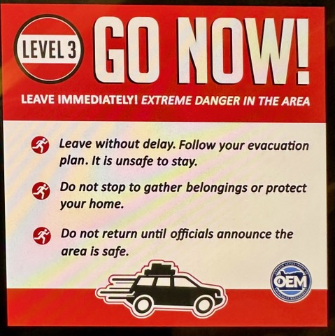
Emergency Alert
Wildfire Alert from Wheeler County Sheriff's Office. Level 3 - GO NOW - Evacuate immediately
from From Alder Creek along Hwy 19-207 E to Hwy 207 at the Heppner junction, Hwy 207 N to mile post 39. Alder Creek North to the Windlock intersection to include city of Spray.
OEM messaging.
“Attention residents of Spray, Oregon: Due to the ongoing emergency, all residents are ordered to EVACUATE IMMEDIATELY. Please proceed to the designated emergency shelter located at Wheeler High School, 600 E 4th St, Fossil, Oregon. Your safety is our top priority. Do not delay. Gather your essential belongings and pets, and leave your homes immediately. Stay safe and follow all instructions from emergency personnel.”
Stage 2 Fire Restrictions go into effect on July 20 07 19 2024
Related Incident:
Publication Type: Announcement
Continuing hot, dry weather, and worsening fire danger conditions have prompted forest officials to expand campfire restrictions across the entire Okanogan-Wenatchee National Forest. Stage 2 Fire Restrictions go into effect on Saturday July 20, banning campfires across the forest, including developed campgrounds and designated Wilderness areas.
Under the forest-wide restriction, the use of wood and charcoal campfires is banned; however, people will still be able to use pressurized or bottled liquid fuel stoves, lanterns, campfires or heating devices if no flammable material is present within three feet of the device. Devices must have an on/off switch or valve that can immediately extinguish the flame. Wood burning camp stoves will not be allowed.
Stage 2 Fire Restrictions also prohibit recreational (target) shooting on the forest. The shooting restriction does not impact lawful hunting under tribal treaty rights or with a valid state-issued license during hunting season.
Visit https://www.fs.usda.gov/goto/fire-restrictions for details on current restrictions.
Firewood cutters must also comply with Industrial Fire Precaution Level requirements found at fortress.wa.gov/dnr/protection/ifpl/
UPDATED EVACUATION ZONES TEXAS RIDGE FIRE 07 19 2024
Related Incident: Texas Fire
Publication Type: Announcement
UPDATED EVACUATION ZONES - TEXAS RIDGE FIRE
As of 1200 on July 19, 2024, all Level 1 and 2 Evacuation zones for the Texas Ridge Fire have been lifted. Level 3 Evacuation zones have slightly changed from what was previously posted on Monday, July 15. A map has been provided for reference.
Level 3 Evacuations are still in effect for the Cedar Creek Canyon area. This includes house on Parsley Dr., Linden Rd., Sister Ln., Elk Ln., and parts of Cedar Ridge Rd.
Vista Fire Morning Update Spanish 07 19 2024
Related Incident: Vista Fire
Publication Type: News
ACTUALIZACIÓN DEL INCIDENTE DE LA MAÑANA
Fecha: 7-19-2024 Hora: 10:30 am
Tamaño: 2936 acres Fecha/hora de inicio: 7-7-24 9:51 a
Contención: 83% Causa: Bajo investigación
Total de personal: 396 Ubicación: Lado sur de Lytle Creek
Estructuras amenazadas: 416
Hoy los bomberos seguirán patrullando las líneas de contención. Dentro de la huella del fuego puede haber algo de calor todavía presente. Los bomberos van a limpiar los puntos calientes que representan una amenaza y se puede acceder con seguridad. La contención ha aumentado al 83%.
Hay un aviso de calor en efecto hoy y las condiciones cálidas y secas en curso aumentan el potencial de nuevos inicios de incendios. Los equipos están listos para responder a cualquier nuevo incendio.
Las actividades de reparación de supresión de incendios están en marcha a lo largo de las líneas de contención y de contingencia. La reparación de la extinción se lleva a cabo para devolver el bosque a las condiciones deseadas y mitigar el futuro impacto medioambiental. Para minimizar la erosión a lo largo de las carreteras, las cuadrillas construirán barras de agua bajo la dirección de asesores de recursos naturales. En la zona del incendio están trabajando equipos pesados, incluidas astilladoras, para reparar las líneas y las carreteras forestales dañadas.
CALIDAD DEL AIRE:
Visita AirNow.gov para obtener información y medidas que puede tomar para protegerse y proteger a sus seres queridos.
CIERRE DE CARRETERAS:
Lytle Creek Road está cerrado al público en general, incluyendo todas las áreas de recreación al norte de Glen Helen Parkway.
EVACUACIONES:
Ninguna.
Nota: En un esfuerzo por comunicar rápidamente información sobre peligros inminentes, el Departamento del Sheriff del Condado de San Bernardino y el Departamento de Bomberos del Condado de San Bernardino envían notificaciones masivas de alta velocidad por teléfono y mensajes de texto. Este sistema se conoce como Sistema Telefónico de Notificación de Emergencias (TENS). Para obtener más información sobre este servicio, visite el sitio web: https://sbcfire.org/alertwarning/.
CIERRES:
Los remontes de Mt. Baldy están autorizados a operar en terrenos, carreteras y senderos que de otro modo estarían cerrados por la Orden Forestal Numero 05-01-24-08. Esta exención se aplica únicamente a los clientes que posean un forfait válido o una reserva con Mt. Baldy Ski Lifts para la zona dentro del Bosque Nacional de los Ángeles. El cierre de la zona sigue en vigor para proteger al público y a los bomberos que están trabajando en la zona del Incendio Vista.
Orden de cierre en vigor en el Bosque Nacional de San Bernardino y el Bosque Nacional de Angeles. Varias carreteras, campings, áreas de picnic, senderos y áreas recreativas dispersas están cerradas al público para garantizar la seguridad de los bomberos, la comunidad y el público. Las actividades recreativas están prohibidas dentro de la zona de cierre. Más información sobre la orden de cierre está disponible en los sitios web de los bosques nacionales en https://www.fs.usda.gov/alerts/sbnf/alerts-notices y https://www.fs.usda.gov/alerts/angeles/alerts-notices.
RESTRICCIONES CONTRA INCENDIOS:
El Bosque Nacional de San Bernardino ha aumentado las restricciones contra incendios. Las hogueras están restringidas a las zonas urbanizadas enumeradas en el Forest Order.
###
Battle Mountain Complex 07 19 2024
Related Incident: Battle Mountain Complex
Publication Type: News
ODF Incident Management Team 3 takes command of the Battle Mountain Complex as fires grow to 1,786 acres
UKIAH, Ore. – The Oregon Department of Forestry’s Incident Management Team 3 took command of the Battle Mountain Complex today, Friday, July 19, at 6 a.m.
Today, crews will focus on holding the fire to keep it as small as possible, while fighting the fire as safely as possible to minimize damage and protect local communities.
The Battle Mountain Complex currently consists of the 930-acre North Fork Owens Fire and the 856-acre Snake Fire. When multiple wildfires are burning in the same general area, officials will designate a fire complex to manage them under a single organization to improve efficiency and simplify incident management processes.
The North Fork Owens and Snake Fires are two of 17 fires in northeast Oregon that started in the late afternoon and evening of July 17, 2024, as a result of the recent lightning event.
Closures: A road closure remains in effect for Highway 395, between mile posts 50 through 90, beginning 35 miles South of Pilot Rock.
Evacuations: Level 1 (Be Ready) , Level 2 (Be Set) and Level 3 (Go Now) evacuations are in effect. For updated evacuation information, visit the Umatilla County Sheriff's Office Facebook page, www.facebook.com/UmatillaCountySheriff, or sign up for the Umatilla County Emergency Alert System at https://member.everbridge.net/index/2590041373147145.
ODF’s Northeast Oregon District is currently in Extreme (red) fire danger and there are additional restrictions for industrial forest operations on lands protected by the Oregon Department of Forestry in Northeast Oregon. Current fire restrictions for forestlands in Northeast Oregon can be found at www.bmidc.org or by calling the Northeast Oregon Fire Prevention line: (541) 975-3027.
For current fire info, go to http://bluemountainfireinfo.blogspot.com/
ODF NEO Facebook: www.facebook.com/oregondeptofforestryNEO/. To report a fire, call Blue Mountain Interagency Dispatch at (541) 963-7171 or dial 9-1-1.
Shelly Fire Morning Update 07 19 2024
Related Incident: Shelly Fire
Publication Type: News
Location: Siskiyou County, CA Start Date: Wednesday July 3, 2024 at 1:27 PM
Size: 15,460 acres Percent Contained: 18%
Cause: Under Investigation Personnel: 2,895
CURRENT SITUATION:
As of today, California Interagency Management Team 1 has joined CAL FIRE Team 6 in unified command on the Shelly Fire, completing the transition from California Interagency Management Team 12 and CAL FIRE Siskiyou Unit.
Yesterday, personnel made good progress in increasing containment along the fire’s north and east perimeter including in the Kidder Creek and Patterson Creek drainage areas, and continued to go direct with air and ground resources along the southern and western portions of the fire. Small pockets of interior fuel continue to burn in some areas; currently they do not pose a major threat to containment lines.
As further progress has been made, evacuation orders and warnings have been reduced accordingly; please visit the Siskiyou County Sherriff Office webpage for the latest information. Drivers in the area should remain alert for fire personnel and heavy equipment on or near the roadways, as crews continue expanding containment lines and addressing any flare-ups around the fire’s perimeter.
WEATHER:
A hot and dry pattern with enhanced terrain-driven winds will continue for the next several days, with a slight chance of isolated thunderstorms Saturday evening.
EVACUATIONS:
For current evacuation status, visit www.facebook.com/SiskiyouCountySheriff and www.facebook.com/SiskiyouCountyOES. Additional evacuation information and a map can be found on the Genasys site at https://protect.genasys.com/search?z=14&latlon=41.550694%2C-122.905589.
SHELTERS:
RV Dry Camping/Parking West Webb St. and Hoag St. in Montague
Please note, at this time, there are no extra services (sewage/water/power hookups). This is currently set up for DRY camping.
Animal shelters are available at the following location(s) for those who have pets and animals displaced due to the Shelly Fire:
Dog Evacuation Shelter:
Rescue Ranch Yreka, 2216 East Oberlin Road, Yreka CA 96097
Contact: John Golay 541-698-7526
Livestock Animal Evacuation Shelter (horses, pigs, sheep, goats, birds):
Siskiyou Golden Fair, 1712 Fairlane Road, Yreka, CA 96097
Contact: Tom Taylor 530-340-1038
Cat Evacuation Shelter:
Siskiyou Golden Fair - Armory Building, 1712 Fairlane Road, Yreka, CA 96097
Contact: Becca 530-340-0656
CLOSURES:
An official forest closure around the Shelly Fire went into effect on July 4th. Hikers are not permitted and will be asked to leave the area. For details and a map of the closure area, please visit https://www.fs.usda.gov/Internet/FSE_DOCUMENTS/fseprd1187463.pdf.
FIRE RESTRICTIONS:
Forest fire restrictions also went into effect on July 4th. Campfires and stove fires are restricted to those developed areas listed in the forest order located at https://www.fs.usda.gov/alerts/klamath/alerts-notices/?aid=88596. Smoking, welding, and operating an internal combustion engine also have restrictions in place.
Pacific Crest Trail Information: https://www.pcta.org/discover-the-trail/closures
Actualizacin diaria del incendio Pioneer y el incendio Easy del 19 de julio 2024 07 19 2024
Related Incident:
Publication Type: News
Varios incendios nuevos fueron causado por más de 800 rayos en Oregón y Washington la noche del 17 de julio. El Nivel 5 de Preparación Nacional se declaró ayer, lo que significa que muchos recursos de extinción de incendios están comprometidos y la posibilidad de inicios de fuegos nuevos es alto. El Equipo 12 del NO ha tomado el mando del incenido Easy (20 millas aéreas al oeste de Mazama) y se encargará de ambos incendios. Los encargados de los incendios están pidiendo más recursos de extinción, a medida que estén disponibles, para reforzar ambos incidentes. El Equipo 3 del NO llegará hoy para informar sobre ambos incendios.
Tamaño del incendio Pioneer: 25,688 acres | Causa: De orígen humano | Contención: 14% | Personal total: 783
Los bomberos trabajaron por todo el valle de Stehekin para fortalecer, mejorar y ampliar los cortafuegos al mismo tiempo que instalan más mangueras para apoyar en proteger la comunidad. Justo al norte de Moore Point, los bomberos construyeron un cortafuego directo hasta la orilla del lago y realizaron una operación de fuego exitosa para fortalecer los cortafuego. Ayer los helicópteros vertieron 110,000 galones de agua en esta área para asistir a los bomberos que preparaban el terreno cerca de Hunts Creek. Los helicópteros trabajarán hoy con cubetas de agua para enfriar y frenar los incendios mientras apoyan a los bomberos en tierra. Están preparados para iniciar operaciones de quema, si es necesrio, para proteger los valores en riesgo, incluyendo las viviendas y la infraestructura. Siguen disponibles los recursos de este incendio para ayudar con ataques iniciales.
Tamaño del incendio Easy: 107 acres | Causa: Rayos | Contención: 0% | Personal total: 35
El incendio Easy fue provocado por las tormentas eléctricas secas que se desplazaron por el valle de Methow. El incendio Pioneer envió recursos de aviación para que realizaran un ataque agresivo inicial contra este nuevo incendio, ya que tuvo un crecimiento grandísimo de fuego. Las cuadrillas permanecieron en el incendio por la noche, pero los esfuerzos de respuesta inicial fueron afectados por semanas de temperaturas extremas, condiciones secas récord y terreno peligroso, combinado con la falta de acceso por carretera. Hasta el día de ayer, el fuego no había cruzado la cresta de la línea divisoria entre los condados de Skagit y Okanogan. Los bomberos están explorando el terreno montañoso para identificar estrategias para usar barreras naturales y otras tácticas de extinción y así contener el fuego.
Seguridad y cierres: El Servicio de Parques Nacionales-North Cascades ha ampliado su lista de cierres: https://www.nps.gov/noca/planyourvisit/fire-closures.htm. El Bosque Nacional Okanogan-Wenatchee ha emitido una orden de cierre sobre gran parte del área afectada por el incendio. Podrá encontrar detalles y mapas disponibles en: https://bit.ly/PioneerClosure. La restricción temporal de vuelo (TFR, en inglés) sobre el área del incendio fue ampliada ayer: https://tfr.faa.gov/save_pages/detail_4_6779.html. La actividad de drones está prohibida por la TFR, ya que los helicópteros no pueden volar si hay drones no autorizados.
Evacuaciones: Los niveles de evacuación de nivel 1, 2 y 3 permanecen vigentes alrededor del incendio Pioneer. Visite https://t.ly/QoH9w para tener más información. No hay evacuaciones vigentes para el incendio Easy, aunque están cerradas secciones del Pacific Crest Trail.
Clima y humo: Permanece en efecto un aviso de calor. Se prevé que para el viernes habrá temperaturas cálidas, cielos soleados y vientos ligeros con baja humedad relativa. Se espera que el humo se disipe un poco por la tarde. El calor casi récord y prolongado,continúa secando los combustibles y está contribuyendo a empeorar la posibilidad de incendios. El pronóstico de la calidad del aire se puede ver en: https://bit.ly/PioneerFireSmoke.. Obtenga más información sobre el humo en http://wasmoke.blogspot.com/. El jefe de bomberos emitió clasificaciones de peligro de incendio y restricciones: https://t.ly/WLBds.
Cougar Creek Fire Update07 19 2024
Related Incident: Cougar Creek Fire
Publication Type: News
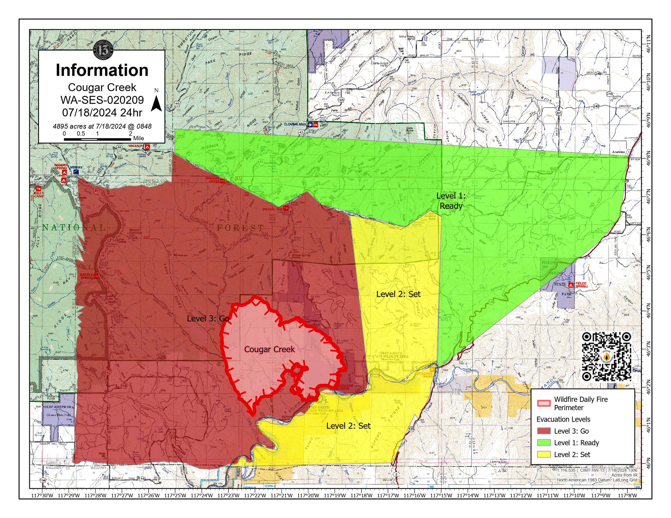
Cougar Creek Fire Update for Friday July 19, 2024
Clarkston, WA – The Cougar Creek Fire is burning in Southeast Washington along the Washington – Oregon boarder, approximately 40 miles SW of Clarkston, WA near Hwy 129. The fire is in rugged rangeland with isolated pockets of timber in a mixed topography of ridgelines, benches, plateaus and secondary drainages.
Complex Incident Management Team Northwest 13 assumed command of the fire yesterday. There has been active fire growth since first reported with moderate fire behavior. The fire is expected to primarily spread north and northwest today. Additional air and ground resources are being ordered and will arrive on incident to support current crews building containment lines. Multiple agencies from County, District, State and Federal agencies are fully engaged in suppression activities.
Incident objectives include protecting adjacent communities, structures, and assets such as timber, rangeland, and livestock through minimizing fire growth. Crews have been directly fighting the fire near Wenatchee Creek and have been aided by an increased amount of green vegetation in the drainage, minimizing acres burned. Night operations are in place, and spike camps are being developed to keep personnel closer to this full suppression fire. To the southwest, crews have been scouting alternative line placement in the Grouse Flats road system and providing structure protection. To the south, crews are controlling and monitoring fire spread along the river system. To the north, retardant is being dropped along ridges to protect from further fire spread.
WEATHER: High pressure will return to the fire on Friday with sunny, hot, and dry weather conditions anticipated. Wind will generally remain light under the expected pattern. Daytime temps will remain in the upper 90s, and additional warming is expected through the weekend and into next week before minor cooling. Minimum humidity is expected to be 10% to 15% today.
The hot and dry weather conditions will support active fire spread. Predicted light winds and smoke cover will keep fire activity from becoming extreme.
SAFETY: There are evacuations levels in effect, please see the evacuation notice from Asotin County Sheriff and Asotin County Emergency Management.
SMOKE: Smoke will continue to be moderate across the area near Troy, Anatone, and Clarkston for the next few days. If you are “unusually sensitive” to particle pollution, consider reducing your activity level or shorten the amount of time you are active outdoors. Smoke levels can change rapidly depending on weather. Check current conditions on AirNow.gov.
CLOSURES: The Grande Ronde Road is closed from Troy, Oregon to the Highway 129 junction. Forest officials are temporarily closing the southeastern portion of the Pomeroy Ranger District located in Asotin County and small portions of Garfield County and Wallowa County on Umatilla National Forest Lands to ensure public safety. This temporary closure will also ensure the safety of firefighters engaged in operations to suppress the Cougar Creek Fire. Fire managers are continually assessing resource needs based on fire spread and behavior. The cause of the fire is currently under investigation.
Pioneer and Easy Fires Update 07 19 2024
Related Incident:
Publication Type: News
Pioneer and Easy Fires Update for July 19, 2024
Incident Commander Jeff Dimke
Complex Incident Management Team Northwest 12
541-861-5808, staffed 8 a.m. to 8 p.m. 2024.pioneer@firenet.gov
Over 800 lighting strikes in Oregon and Washington the night of July 17 led to numerous new fires. National Preparedness Level 5 was declared yesterday, meaning many firefighting resources are committed and the potential for new starts is high. NW Team 12 has taken command of the Easy Fire (20 air miles west of Mazama) and will manage both fires. Fire managers are requesting more firefighting resources, as they become available, to bolster both incidents. NW Team 3 arrives today to inbrief on both fires.
Pioneer Fire Size: 26, 137 acres | Cause: Human-caused | Containment: 14% | Total personnel: 782
Firefighters worked across the Stehekin Valley to strengthen, improve, and extend firelines while increasing hose lays to support community protection. Just north of Moore Point, firefighters constructed direct fireline to the lake’s edge and executed a successful firing operation to secure firelines. Helicopters dropped 110,000 gallons of water in this area yesterday to support firefighters securing the ground near Hunts Creek. Helicopters will be working water buckets today to cool and slow the fires as they support firefighters on the ground. If necessary, firefighters are prepared to initiate firing operations to protect values at risk, including homes and infrastructure. Resources from this fire remain available to assist with initial attack.
Easy Fire Size: 107 acres | Cause: Lightning | Containment: 0% | Total personnel: 35
Dry lightning storms that moved through the Methow Valley started the Easy Fire. The Pioneer Fire dispatched aviation resources as part of the aggressive initial attack on this new fire, which was experiencing explosive fire growth. Crews remained on the fire overnight but weeks of extreme temperatures, record dry conditions, and dangerous terrain combined with no road access hampered initial response efforts. As of yesterday, the fire had not crossed the Skagit-Okanogan county line ridge. Firefighters are scouting the mountainous terrain to identify strategies using natural barriers and other suppression tactics to contain the fire.
Safety and Closures: The National Park Service-North Cascades has expanded their list of closures: https://www.nps.gov/noca/planyourvisit/fire-closures.htm. The Okanogan-Wenatchee National Forest has a closure order in place: https://bit.ly/PioneerClosure. There are two Temporary Flight Restrictions (TFRs) in place over the fires: https://tinyurl.com/wduxpesz (Pioneer) and https://tinyurl.com/mtxej9zj (Easy). Drone activity is prohibited within the TFRs.
Evacuations: Level 1, 2 and 3 evacuation levels remain in effect around the Pioneer Fire. Please visit https://t.ly/QoH9w for more information. There are no evacuations in place for the Easy Fire though portions of the Pacific Crest Trail are closed.
Weather and Smoke: A Heat Advisory remains in place. Friday's forecast calls for hot temperatures, sunny skies and light winds with low relative humidity. Smoke should clear up some in the afternoon. Extended, near record-breaking heat, continues to dry fuels and contributes to heightened fire potential. The air quality outlook can be found at: https://bit.ly/PioneerFireSmoke. Learn more about smoke at http://wasmoke.blogspot.com/. The fire marshal issued fire danger ratings and restrictions: https://t.ly/WLBds.