
Dolan Fire Update September 29 2020
Related Incident:
Publication Type: News
Fire Information Line:
Incident Update
Dolan Fire
9/29/20
831-272-0222
Release Date:
9/29/20
Media Line:
831-272-0221
Incident Name:
Dolan Fire
Type of Incident:
Wildland
Incident Location:
Monterey County CA
Incident Report Date:
08/18/2020
Fire Cause:
Under investigation
Incident Report Time:
20:04
Acres:
124,924
% Contained:
85%
Structures Damaged:
4
Habitable Structures Destroyed:
14
Fatalities :
0
Outbuildings Destroyed:
5
Resources Assigned
Engines:
28
Helicopters:
5
Bulldozers:
1
Water Tenders:
10
Air Tankers:
Actualizacin de incidente Incendio de Dolan 9282020
Related Incident:
Publication Type: News
Información sobre el incendio:
Actualización de incidente
Incendio de Dolan
9/28/20
831-272-0222
Fecha de lanzamiento:
9/28/20
Información sobre la media:
831-272-0221
Nombre del Incidente:
Incendio de Dolan
Tipo de incidente:
Incendio Forestal
Ubicación de incidente:
Condado de Monterey CA
Fecha de Comienzo del Incidente:
08/18/2020
Causa:
Bajo Investigación
Hora del informe de incidentes:
20:04
Acres:
128,417
% de Contención:
62%
Estructuras Dañadas:
4
Estructuras habitables destruidas:
14
Fatalidades:
0
Dependencias destruidas:
5
Recursos Asignados
Autobomba:
28
Helicópteros:
5
Bulldozers:
1
Camión Cisterna:
10
Dolan Fire Update September 28 2020
Related Incident:
Publication Type: News
Fire Information Line:
Incident Update
Dolan Fire
9/28/20
831-272-0222
Release Date:
9/28/20
Media Line:
831-272-0221
Incident Name:
Dolan Fire
Type of Incident:
Wildland
Incident Location:
Monterey County CA
Incident Report Date:
08/18/2020
Fire Cause:
Under investigation
Incident Report Time:
20:04
Acres:
128,417
% Contained:
62%
Structures Damaged:
4
Habitable Structures Destroyed:
14
Fatalities :
0
Outbuildings Destroyed:
5
Resources Assigned
Engines:
28
Helicopters:
5
Bulldozers:
1
Water Tenders:
10
Air Tankers:
Dolan Fire Update September 27 2020
Related Incident:
Publication Type: News
Fire Information Line:
Incident Update
Dolan Fire
9/27/20
831-272-0222
Release Date:
9/27/20
Media Line:
831-272-0221
Incident Name:
Dolan Fire
Type of Incident:
Wildland
Incident Location:
Monterey County CA
Incident Report Date:
08/18/2020
Fire Cause:
Under investigation
Incident Report Time:
20:04
Acres:
128,417
% Contained:
62%
Structures Damaged:
4
Habitable Structures Destroyed:
14
Fatalities :
0
Outbuildings Destroyed:
5
Resources Assigned
Engines:
28
Helicopters:
5
Bulldozers:
1
Water Tenders:
10
Air Tankers:
Actualizacin de incidente
Related Incident:
Publication Type: News
Información sobre el incendio:
Actualización de incidente
Incendio de Dolan
9/27/20
831-272-0222
Fecha de lanzamiento:
9/27/20
Información sobre la media:
831-272-0221
Nombre del Incidente:
Incendio de Dolan
Tipo de incidente:
Incendio Forestal
Ubicación de incidente:
Condado de Monterey CA
Fecha de Comienzo del Incidente:
08/18/2020
Causa:
Bajo Investigación
Hora del informe de incidentes:
20:04
Acres:
128,417
% de Contención:
62%
Estructuras Dañadas:
4
Estructuras habitables destruidas:
14
Fatalidades:
0
Dependencias destruidas:
5
Recursos Asignados
Autobomba:
28
Helicópteros:
5
Bulldozers:
1
Camión Cisterna:
10
Actualizado el 26 de Septiembre del 2020
Related Incident:
Publication Type: News
Ayer fue otro día exitoso, con una actividad mínima del fuego, lo que permitió a los bomberos progresar en la seguridad de McKern Road y el aumento de la contención del incendio de Dolan.
Hay pronóstico de vientos desde el norte en el día de hoy, las cuadrillas continúan con las actividades planificadas de liquidación, contención y aseguración del perímetro sur del incendio. Se espera que las temperaturas estén por debajo de los 90 grados, con un aumento progresivo en los próximos días, alcanzando los 100 grados el lunes, posiblemente. Las condiciones extremadamente cálidas y secas puedan crear que los focos de calor se activen e incrementen el comportamiento del fuego. Los bomberos se mantienen alertos a cualquier incremento de la actividad del fuego a través de varios puntos de observación en el incendio de Dolan que abarca cerca de 200 millas cuadradas a lo largo de la costa central. Con el consenso de "buscar y destruir", los bomberos continúan utilizando la tecnología infrarroja junto a la observación aérea para detectar focos de calor y enviar bomberos para atacar estos puntos cerca del perímetro. Los gerentes pueden cuentan con varias herramientas para hacer esto: envío de cuadrillas y equipos en UTV (vehículos todo terreno) para llegar a estos puntos de incendio de difícil acceso o proporcionar el apoyo continuo de helicópteros que lanzan agua en áreas más inaccesibles.
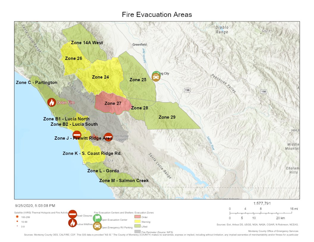
Evacuaciones: La Oficina del Sheriff del Condado de Monterey levantó la advertencia de evacuación para la Zona 28. Todas las demás ÓRDENES y ADVERTENCIAS de evacuación siguen en efecto. Para obtener información actualizada sobre la evacuación, consulte el mapa interactivo de OES o llame al 211.
Cierres: El Bosque Nacional Los Padres extendió su cierre de recreación hasta el 1 de Octubre del 2020. La carretera Nacimiento-Ferguson está cerrada a todo el tráfico desde la carretera 1 hasta la línea fronteriza de la base de Fort Hunter Liggett. Para obtener más información, visite https://roads.dot.ca.gov/.
Dolan Fire Update September 26 2020
Related Incident:
Publication Type: News
Firefighters had another successful day with minimal fire activity yesterday which allowed them to make good progress on holding and securing McKern Road to increase containment on the Dolan Fire.
With winds forecasted out of the north today, crews are continuing the methodical work of mopping up, holding and securing the southern fire perimeter. Temperatures are expected to be in the low 90s and will continue an upward trend in the next several days potentially reaching triple digits on Monday. Extremely hot and dry conditions could mean pockets of heat ignite into flames and increase fire behavior. Firefighters remain diligent watching for any increase in fire behavior from numerous vantage points on the Dolan Fire that covers approximately 200 square miles along the Central Coast. With a mantra of “seek and destroy” firefighters continue the use infrared technology in conjunction with aerial reconnaissance to find pockets of heat and send crews in to attack hot spots near the perimeter. Fire managers are able to use a variety of tools to tackle these hot spots including sending crews and equipment on UTVs (Utility Terrain Vehicle) to access the fire in rugged terrain or providing the ongoing support of helicopters doing water drops for fire in more inaccessible areas.
Evacuations: The Monterey County Sheriff’s Office lifted the evacuation warning for Zone 28. All other evacuations ORDERS and WARNINGS in effect. For current evacuation information view the OES interactive map or call 211.
Closures: The Los Padres National Forest extended the forest recreation closure through October 1, 2020. Nacimiento-Ferguson Road is closed to all traffic from Highway 1 to the Fort Hunter Liggett base boundary line. For more information visit https://roads.dot.ca.gov/
Dolan Fire Evacution WARNING lifted in Zone 28
Related Incident:
Publication Type: Announcement
The Evacuation WARNING has been lifted for Zone 28 of the Dolan Fire.
La ADVERTENCIA de evacuación se ha levantado para la Zona 28 del Incendio Dolan.
Pacific Southwest Region Emergency Forest Closure
Related Incident:
Publication Type: Closures
Pursuant to 16 U.S.C. § 551 and 36 C.F.R. § 261.50(a) and (b), and to provide for public safety and protect natural resources, the following acts are prohibited on National Forest System lands within the Pacific Southwest Region. This Order is effective from September 25, 2020, through September 30, 2020.
1. Going into or being upon National Forest System lands within the National Forests listed below.
a. Angeles National Forest
b. Cleveland National Forest
c. Los Padres National Forest
d. San Bernardino National Forest
e. Inyo National Forest
f. Sequoia National Forest
g. Sierra National Forest
h. Klamath National Forest
i. Six Rivers National Forest
36 C.F.R. § 261.52(e).
2. Being on a National Forest System road within the National Forests listed below.
a. Angeles National Forest
b. Cleveland National Forest
c. Los Padres National Forest
d. San Bernardino National Forest
e. Inyo National Forest
f. Sequoia National Forest
g. Sierra National Forest
h. Klamath National Forest
i. Six Rivers National Forest
36 C.F.R. § 261.54(e).
3. Being on a National Forest System trail within the National Forests listed below.
a. Angeles National Forest
b. Cleveland National Forest
c. Los Padres National Forest
d. San Bernardino National Forest
e. Inyo National Forest
f. Sequoia National Forest
g. Sierra National Forest
h. Klamath National Forest
i. Six Rivers National Forest
36 C.F.R. § 261.55(a).
Pursuant to 36 C.F.R. § 261.50(e), the following persons are exempt from this Order:
1. Persons with Forest Service Permit No. FS-7700-48 (Permit for Use of Roads, Trails, or Areas Restricted by Regulation or Order), specifically exempting them from this Order
2. Any Federal, State, or local officer, or member of an organized rescue or fire fighting force in the Performance of an official duty.
3. Persons with a Forest Service non-special-use written authorization to conduct non-recreational activities, such as harvesting timber or forest products, or grazing livestock.
4. Owners or lessees of land, to the extent necessary to access their land.
5. Residents, to the extent necessary to access their residences.
6. Persons engaged in a business, trade, or occupation are not exempt from the prohibitions listed above, but may use National Forest System roads to the extent necessary to carry out their business, trade, or occupation.
These prohibitions are in addition to the general prohibitions contained in 36 C.F.R. Part 261, Subpart A.
A violation of these prohibitions is punishable by a fine of not more than $5,000 for an individual or $10,000 for an organization, or imprisonment for not more than 6 months, or both. 16 U.S.C. § 551 and 18 U.S.C. §§ 3559, 3571, and 3581.
Done at Vallejo, California, this 24th day of September, 2020.
RANDY MOORE
Regional Forester Pacific Southwest Region
Pacific Southwest Region Emergency Fire Restrictions
Related Incident:
Publication Type: Closures
Pursuant to 16 U.S.C. § 551 and 36 C.F.R. § 261.50(a), and to provide for public safety and protect natural resources, the following acts are prohibited on National Forest System lands within the Pacific Southwest Region. This Order is effective from September 25, 2020, through September 30, 2020.
1. Building, maintaining, attending or using a fire, campfire, or stove fire. 36 C.F.R. § 261.52(a).
2. Smoking. 36 C.F.R. § 261.52(c).
Pursuant to 36 C.F.R. § 261.50(e), the following persons are exempt from this Order:
1. Persons with Forest Service Permit No. FS-7700-48 (Permit for Use of Roads, Trails, or Areas Restricted by Regulation or Order), specifically exempting them from this Order.
2. Any Federal, State, or local officer, or member of an organized rescue or fire fighting force in the Performance of an official duty.
These prohibitions are in addition to the general prohibitions contained in 36 C.F.R. Part 261, Subpart A.
A violation of these prohibitions is punishable by a fine of not more than $5,000 for an individual or $10,000 for an organization, or imprisonment for not more than 6 months, or both. 16 U.S.C. § 551 and 18 U.S.C. §§ 3559, 3571, and 3581.
Done at Vallejo, California, this 24th day of September, 2020.
RANDY MOORE
Regional Forester
Pacific Southwest Region