
Mullen Fire Daily Fact Sheet 1082020
Related Incident:
Publication Type: News
Location
The Mullen Fire is approximately 38 miles west of Laramie, Wyoming.
Size & Resources
Roughly 170,996 acres as of 1 am 10/8 IR Approximately 1079 firefighters and support staff
Containment
14% contained, mostly along the west portion of Hwy 230 in the Platte River Valley in Wyoming, Hwy 125 and Hwy 127 in Colorado, and a piece to the west of Woods Landing.
Overview
Fire crews assessed need and ordered supplies for structure protection in the Ryan Park and Centennial areas in the event the fire moves closer. Citizens can expect to see additional firefighter traffic and activity over the coming days there and along Hwy 130.
Late yesterday a burnout was conducted to secure the area about four miles north of A Bar A ranch in the NW section of the fire. The fireline is now tied into some hard barriers and a creek.
While the north perimeter is resistant to containment due to heavy concentrations of dead and down fuels, the fire is being held in the Rambler area along Hwy 338. Structure protection efforts there and around Keystone are successful. Helicopters will be assisting with water drops.
Fire has worked its way around Albany. Firefighters will focus suppression efforts in the transition between timber and grasslands along the old railroad line between Albany and Centennial. Fixed wing aircraft will be helping to fortify that line as clear air allows.
Grazing lands between Albany and Sheep Mountain provide a fuel break for firefighters assisted by fixed wing aircraft and retardant to limit fire spread to east as conditions allow.
Firefighters are working to cool the heat in the finger burning west of Woods landing.
Structure protection efforts in the Foxborough and Fox Park areas have been successful as they have been in the Mountain Home area although there is a bit more heat in that area.
Fire Weather
Thursday: A red flag warning is in effect from 9 am until 8 pm. Continued warm and dry with high 62-69 degrees. Increasing winds from WSW of 13-18 mph, gusting to 25-30 mph after 10 am. Minimum RH 9-15%. Smoke on the east side of the fire.
Friday: Very dry and continued warm with high 62-69 degrees. WSW winds of 12-17 mph, gusting to 25 to 30 mph. Minimum relative humidity (RH) 8-14%.
Saturday Late: Cold front dropping temps by 25 degrees with chance of snow in upper elevations.
Meetings
Virtual Community Q&A TODAY at 5 p.m.
Livestreamed on the Mullen Fire Information page (https://www.facebook.com/MullenFire)
Fire Cause
Under investigation. Call Laramie Ranger District anonymous tip line, (307) 745-2392.
Closures
Road closures: https://www.wyoroad.info/pls/Browse/WRR.STATIC5?SelectedDistrict=1 and https://cotrip.org/home.htm
Medicine-Bow Routt National Forests: https://tinyurl.com/y4gb8bqs
Arapaho Roosevelt National Forests: https://tinyurl.com/y2e3qn3y
BLM Emergency Area Closure: https://inciweb.nwcg.gov/incident/article/7208/57387/
General Fire Information
Email: 2020.Mullen@Firenet.gov
Inciweb: http://inciweb.nwcg.gov/incident/7208
Facebook: https://www.facebook.com/MullenFire/, #MullenFire_WY
Twitter: Medicine Bow-Routt National Forests and Thunder Basin National Grassland @FS_MBRTB, #MullenFire_WY
Public and firefighter safety is the number one priority.
Help protect your home from wildfires using tips from www.firewise.org.
Mullen Fire Daily Update 1230 pm 1072020
Related Incident:
Publication Type: News
Virtual Community Q&A TODAY at 5 p.m.
The meeting will be livestreamed on the Mullen Fire Information page (https://www.facebook.com/MullenFire)
Summary
The fire progressed slightly to the northeast and east over the last 24 hours. Containment has remained at 14% as of this morning. late yesterday in spite of the Red Flag Warning in place for most of the day. Significant structure protection activities took place in Albany and other communities threatened by the fire and structure protection will continue to be a priority. This includes moving brush and firewood, laying water hoses, and installing sprinkler systems.
Albany County crews established and strengthened indirect fire lines to slow potential spread towards Centennial, and aerial resources will drop retardant along those fire lines to reinforce them.
Fire Conditions and Weather
Active burning in heavy dead and down fuels is expected.
Today is expected to be warm and dry with lighter winds from the southwest and gusts up to 20 mph. Afternoon relative humidity levels are forecast to be around 10%. Smoke is expected to be reduced somewhat in the immediate vicinity of the fire and allow increased use of aerial resources.
Thursday will continue to be warm and dry with increasing winds from the southwest to west and gusts to 30 mph. The relative humidity will remain low at around 10%.
Road and Forest Closures
Road status can change quickly in response to fire conditions. Colorado Hwy127 and Wyoming Hwy230 on the west side of the fire is now open. For the most current information on Wyoming and Colorado road closures, please see https://www.wyoroad.info/pls/Browse/WRR.STATIC5?SelectedDistrict=1 and https://cotrip.org/travelAlerts.htm#?roadId= No estimate is available about reopening these roads.
A Forest area closure is in effect surrounding the Mullen Fire for public safety. See the new Forest Closure Orders for Medicine-Bow Routt NF https://tinyurl.com/y4gb8bqs and Arapaho Roosevelt NF https://tinyurl.com/y2e3qn3y For BLM Emergency Area Closure for areas near the fire, see Closures on https://inciweb.nwcg.gov/incident/7208/
Mullen Fire Daily Update 1200 pm 1062020
Related Incident:
Publication Type: News
Virtual Community Q&A TODAY at 5 p.m.
The meeting will be livestreamed on the Mullen Fire Information page (https://www.facebook.com/MullenFire)
Yesterday was a transition day between the outgoing Rocky Mountain Type 2 Blue team and the incoming Southern Area Type 1 Blue team. Thanks for all the efforts and helping the Southern team hit the ground running.
Containment remained at 14% as of late yesterday in spite of the Red Flag Warning in place for most of the day. Warm, dry, and windy conditions produced critical fire weather that yielded fire perimeter growth mainly on the northwest and then on the east central perimeter of the fire once the winds shifted out of the northwest. Crews worked to hold and improve lines widened by previous firing operations that were initiated to increase line depth and contain potential long-range spotting across WY230.
Point protection continued in the communities threatened by the Mullen Fire.
Structure protection crews implemented strategies to defend structures in the event the flame front approaches.
Today is expected to be another day with critical fire weather with westerly winds increasing and gusting up to 30 mph. Humidity is expected to lower to around 10% in the afternoon. Smoke may impact air operations.
Warm and dry conditions are expected for Wednesday through Friday. Poor humidity recovery will be expected each night with somewhat diminished winds on Wednesday. Winds will increase again on Thursday and Friday.
Road and Forest Closures
Road status can change quickly in response to fire conditions. Colorado Hwy127 and Wyoming Hwy230 on the west side of the fire is now open. For the most current information on Wyoming and Colorado road closures, please see https://www.wyoroad.info/pls/Browse/WRR.STATIC5?SelectedDistrict=1 and https://cotrip.org/travelAlerts.htm#?roadId= No estimate is available about reopening these roads.
A Forest area closure is in effect surrounding the Mullen Fire for public safety. See the new Forest Closure Orders for Medicine-Bow Routt NF https://tinyurl.com/y4gb8bqs and Arapaho Roosevelt NF https://tinyurl.com/y2e3qn3y For BLM Emergency Area Closure for areas near the fire, see Closures on https://inciweb.nwcg.gov/incident/7208/
Mullen Fire Daily Update 1052020
Related Incident:
Publication Type: News
Virtual Community Q&A TODAY at 5 p.m.
The meeting will be livestreamed on the Mullen Fire Information page (https://www.facebook.com/MullenFire)
Summary
Fire managers measured increased containment at 14% and continued aggressive firing operations to secure lines in several locations, including the northwest, northcentral and southeast areas of the fire. On north/northwest corner, crews worked to tie in lines to the 500 road north of the Savage Run Wilderness to keep the fire south of the road. Along the north central flank, the multi-day firing neared completion along the 542 road. They also tied into the Keystone Fire scar, and worked in front of the fire in the Rob Roy and Cinnabar Park areas. Thick smoke from these multiple operations was carried into to Laramie by the robust west wind. The volume of smoke from the northwest reflected the area’s fuel density.
To the southeast, aerial ignitions took place between the fire’s edge between Miller’s Lake and the Pelton Creek area to protect Woods Landing, increase line depth, and contain potential long range spotting across WY230. Structure protection in the communities to the west of WY230 is ongoing in preparation for offensive firing. Smoke eventually grounded air operations.
Today, crews will scout opportunities to establish indirect lines along the northern flank, and complete the Rob Roy-area firing operations, and continue holding line, patrolling and mop up to the south of Albany and in the WY230 corridor. Structure protection crews will begin assessing Ryan Park and Centennial. Smoke may impact support from air operations.
Fire Conditions and Weather
Poor overnight humidity recover, the onset of a drying trend, and northwest winds gusting to 35mph prompted a Red Flag warning from 9 a.m. to 7 p.m. Winds will be westerly to start the day and transition west/northwest by 10 a.m. with a weak front. Warmer and drier weather is expected.
Mandatory Evacuations
Multiple evacuations and pre-evacuations are in place. For current information, see:
- Albany County Sheriff Office (WY) Facebook page: https://www.facebook.com/Albany-County-Sheriffs-Office-618424944997540
- Jackson County Sheriff’s Office (CO) Facebook page: https://www.facebook.com/JacksonCountySheriffOffice
- Larimer County (CO) website: https://www.larimer.org/emergency/emergency-information
Road status can change quickly change in response to fire conditions. Colorado Hwy127 and Wyoming Hwy230 on the west side of the fire is now open. For the most current information on Wyoming and Colorado road closures, please see https://www.wyoroad.info/pls/Browse/WRR.STATIC5?SelectedDistrict=1 and https://cotrip.org/travelAlerts.htm#?roadId= No estimate is available about reopening these roads.
A Forest area closure is in effect surrounding the Mullen Fire for public safety. See the new Forest Closure Orders for Medicine-Bow Routt NF https://tinyurl.com/y4gb8bqs and Arapaho Roosevelt NF https://tinyurl.com/y2e3qn3y For BLM Emergency Area Closure for areas near the fire, see Closures on https://inciweb.nwcg.gov/incident/7208/
Stage 2 Fire Restrictions in Effect for the Fire Area
- Medicine Bow-Routt National Forests and Thunder Basin National Grassland: https://www.fs.usda.gov/Internet/FSE_DOCUMENTS/fseprd786902.pdf
- Albany County: https://www.co.albany.wy.us/247/Fire-Restrictions
Temporary Flight Restriction
A Mullen Fire Temporary Flight Restriction was issued October 1: https://tfr.faa.gov/save_pages/detail_0_6107.html
Morning operations update 800am 1052020
Related Incident:
Publication Type: News
Good morning! An infrared flight last evening showed that the Mullen Fire has grown to 151,700 acres. Containment is 14% and there are 1,104 firefighters working on the fire. Yesterday, firefighters conducted successful firing operations in several locations around the perimeter of the fire to widen existing firelines. Structure protection remains in place throughout the fire area.
Today is going to be a Red Flag day with low humidity levels and strong west winds, which will switch to the northwest. Expect wind gusts to 35 mph throughout the day with active burning as fire consumes dead and down fuels. Smoke production will be high again today and will spread to the east as fuel within the fire perimeter is consumed.
A printable PDF version of today’s map is available in the Inciweb Maps section.
Evening Update 930 pm 1042020
Related Incident:
Publication Type: Announcement
As expected, today was an active day on the Mullen Fire. Crews conducted firing operations in the north above the Savage Run Wilderness in an effort to remove fuels ahead of the fire. Firing was also accomplished in the Keystone area near the 542 Road and in The Sawmill Park area near Hwy 230. Good burning conditions resulted in large amounts of smoke which spread east into the Laramie Valley. Current acreage total is 147,127 with containment at 14%. 1104 personnel are working on the fire.
Our interactive Story Map: https://arcg.is/1mnyXL
Midday operations update 315 pm 1042020
Related Incident:
Publication Type: Announcement
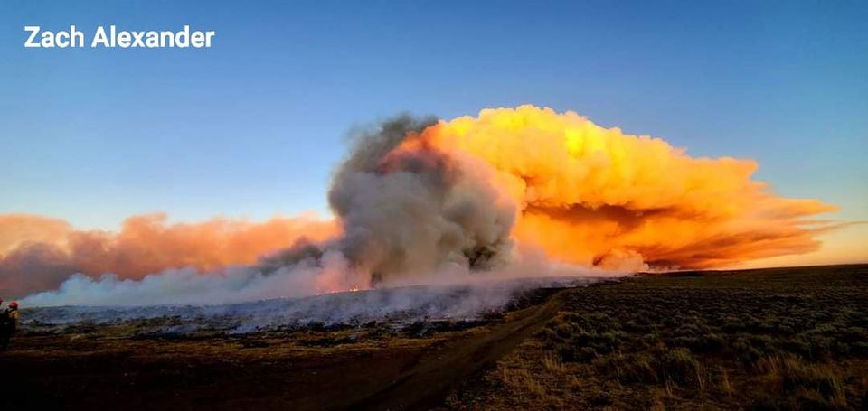
Fire crews on the #MullenFire_WY are taking advantage of favorable afternoon wind direction to conduct firing operations on the Northwest corner of the fire, in the area east of Fox Park along Wyoming Hwy 230 and in the southwest part of the fire along Colorado Hwy 127. These intentional firing operations have been producing a lot of smoke that is visible to the communities east of the fire.See today’s attached smoke outlook.
Mullen Fire Daily Update 1045 am 1042020
Related Incident:
Publication Type: News
The meeting will be livestreamed on the Mullen Fire Information page (https://www.facebook.com/MullenFire)
Road status can change quickly change in response to fire conditions. Colorado Hwy127 and Wyoming Hwy230 on the west side of the fire is now open. For the most current information on Wyoming and Colorado road closures, please see https://www.wyoroad.info/pls/Browse/WRR.STATIC5?SelectedDistrict=1 and https://cotrip.org/travelAlerts.htm#?roadId= No estimate is available about reopening these roads.
A Forest area closure is in effect surrounding the Mullen Fire for public safety. See the new Forest Closure Orders for Medicine-Bow Route NF https://tinyurl.com/y4gb8bqs and Arapaho Roosevelt NF https://tinyurl.com/y2e3qn3y For BLM Emergency Area Closure for areas near the fire, see Closures on https://inciweb.nwcg.gov/incident/7208/
Morning operations update 644 am 1042020
Related Incident:
Publication Type: Announcement
Today is National Fallen Firefighters Memorial Day, the first Sunday in October. American flags across the country have been lowered today, including the U.S. Capitol and the White House, as well as our #MullenFire_WY Incident Command Post and Forward Operating Base.When you lower your flag this year, you will recognize the brave men and women who died protecting their communities from natural and manmade emergencies and disasters, and those who carry on the proud tradition.
Last night at 12:06 am, an infrared flight measured the Mullen Fire at 140,140 acres, with 11% containment. Last night, hundreds of firefighters diligently protected evacuated communities in all areas of the fire, and worked to hold and improve control lines.
More details will be available in this morning’s video briefing from Operations, and in today’s Daily Update. Printable paper maps will be posted as soon as they are available.
Our interactive Story Map (https://arcg.is/1mnyXL) displays the new perimeters of both the Mullen Fire and the Cameron Peak Fire. This online map includes features to look up your address and measure the distance to the fire – or between the fires.
Evening Operations Update 755 pm 1032020
Related Incident:
Publication Type: News
Today has been a safe and productive day. Firing operations were conducted in strategic, small scale operations that have been effective in removing unburned fuel between containment features and the fire’s edge. Firing operations were conducted to protect structures and successful burnouts were accomplished in the far south portion of the fire.
The burnout line established earlier along Colorado Hwy 125 has been holding and crews were able to go direct on the fire’s edge along the southwest flank. Crews were able to use a number of small firing operations to widen control lines here.
Indirect line construction continues to the north of the Rob Roy Reservoir around Rambler to tie off the northeast part of the fire, and structure protection is being conducted in all areas of the fire. Public and firefighter safety remains the number one priority, and to date there have been only several minor injuries received by firefighters.
Check out our interactive Story Map (https://arcg.is/1mnyXL). This map shows the most recent perimeters of both the Mullen Fire and Cameron Peak Fire, and includes features to look up your address and measure the distance to the fire – or between the fires.