
Mullen Fire Daily Fact Sheet 102020
Related Incident:
Publication Type: News
Location
The Mullen Fire is approximately 38 miles west of Laramie, Wyoming.
Size & Resources
Roughly 176,854 acres as of 10/19. Approximately 445 firefighters and support staff.
Evacuation Area Update
Related Incident:
Publication Type: Announcement
Evacuation Area Update
From the Albany County Sheriff’s Office
Effective 10/20/20 at 9:00 AM
The following areas will change from mandatory evacuation to pre-evacuation at the above date and time:
-Porter Ranch/Pelton Creek
-Fox Park
-Miller Lake
-Foxborough
-Dry Park
Those who own property in these areas will be allowed to access their private property only. As a reminder there is still a forest closure in place. Access to Porter Ranch/Pelton Creek, Fox Park, Miller Lake and Foxborough will be from the Highway 230 side. You will be required to stop and check in with the forest security prior to entering. Property owners in Dry Park can access the area through Albany on FS 500.
There are no longer any mandatory evacuation areas related to Mullen Fire. All previous pre-evacuation areas remain the same.
Personal Property Recovery
Related Incident:
Publication Type: Announcement
There is now a permit process in place for owners of trailers that were left during evacuations from the Mullen Fire for access and removal. Those requesting a permit to remove property on the Medicine Bow-Routt National Forests will need to email 2020.Mullen@firenet.gov with the following information: Subject line: Personal Property Recovery PermitsText: Name, contact information, description and location of property
Mullen Fire Daily Fact Sheet 102120
Related Incident:
Publication Type: News
Location
The Mullen Fire is approximately 38 miles west of Laramie, Wyoming.
Size & Resources
Roughly 176,853 acres as of 10/21. Approximately 445 firefighters and support staff.
Containment
73% contained on the western, southern, and eastern edges.
Overview
Normal 0 false false false EN-US X-NONE X-NONE
The fire remains quiet, although private landowners may see residual smoke and flames inside the fire as isolated heavy fuels smolder.
Fire personnel are monitoring the fire, mopping-up, removing equipment and repairing damage. Chipping and brushing operations continue in multiple areas of the fire.
Residents are asked to be alert for hazards near burned areas, including fire-weakened trees, smoldering or burning fuels, firefighting trucks and heavy equipment.
A National Forest area closure remains in place for much of the southern Snowy Range. The closure is being evaluated daily.
For evacuation and closure area information, please refer to the Albany County Sheriff Facebook page: https://www.facebook.com/Albany-County-Sheriffs-Office-618424944997540
Notices
Landowners with private lands affected or damaged by fire suppression activities are invited to submit questions or concerns about repair efforts to 2020.Mullen@firenet.gov. Please include your name, address, phone number, inquiry, question or concern. Email subject line: Private Land Suppression Repair.
Those requesting a permit to remove property on the Medicine Bow-Routt National Forests can email 2020.Mullen@firenet.gov. Please include your name, contact information, description and location of property. Email subject line: Personal Property Recovery Permits.Fire Weather
Normal 0 false false false EN-US X-NONE X-NONE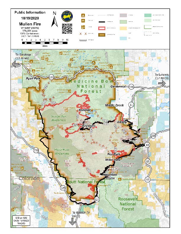
Suppression Repair
Related Incident:
Publication Type: Announcement
Mullen Fire Daily Fact Sheet 101820
Related Incident:
Publication Type: News
Location
The Mullen Fire is approximately 28 miles west of Laramie, Wyoming.
Size & Resources
Roughly 176,840 acres as of 10/17, 8:00 p.m. Approximately 818 firefighters and support staff.
Containment
34% contained, on the western, southern, and southeastern edges
Overview
Those traveling on reopened roads will see smoke and smoldering fires, particularly at night. Firefighters continue to patrol, monitor, and mop up hotspots.
The contingency line was completed near Centennial on Saturday.
Yesterday’s precipitation helped quiet the fire in the higher elevation areas. Firefighters were halted in chipping and brushing operations due to unsafe travel conditions. This work will resume as weather permits.
Firefighters continue to work in the Foxborough, Fox Park, and Porter Creek areas. Suppression efforts will be completed in the coming days in anticipation of reentry into these areas.
Interior burning with visible flame and smoke is expected to continue until significant snowfall.
Residents accessing their property should remain alert for hazards due to smoldering or burning fuels, fire-weakened trees, and the operation of truck and heavy equipment used in firefighting, tree removal, and rehabilitation.
For evacuation and closure area information, please refer to the Albany County Sheriff Facebook page. https://www.facebook.com/Albany-County-Sheriffs-Office-618424944997540/
Fire Weather
Sunday: Mostly cloudy with a chance of showers. High 45-50. West winds 20-30 mph with gusts to 40 mph.
Monday: Partly cloudy and warmer. High 50-55. Winds out of the west 15-25 mph.
Tuesday: Mostly clear. Lows in the 30s. Highs around 50. West winds around 15 mph.
Meetings
Virtual Community Q&A TODAY at 5 p.m.
Livestreamed on the Mullen Fire Information page https://www.facebook.com/MullenFire
Fire Cause
Under investigation. Call Laramie Ranger District anonymous tip line: (307) 745-2392
Closures
Road closures: https://www.wyoroad.info/pls/Browse/WRR.STATIC5?SelectedDistrict=1 and https://cotrip.org/home.htm
Medicine Bow-Routt National Forests: https://www.fs.usda.gov/detailfull/mbr/alerts-notices/?cid=stelprdb5139680&width=full (updated October 15)
Arapaho & Roosevelt National Forests: https://tinyurl.com/yxnxrnt2 (updated October 11)
BLM Emergency Area Closure: https://inciweb.nwcg.gov/incident/article/7208/57387/
General Fire Information
Email: 2020.Mullen@Firenet.gov
Inciweb: http://inciweb.nwcg.gov/incident/7208
Facebook: https://www.facebook.com/MullenFire, #MullenFire_WY
Twitter: Medicine Bow-Routt National Forests and Thunder Basin National Grassland @FS_MBRTB, #MullenFire_WY
Public and firefighter safety is the number one priority.
Help protect your home from wildfires using tips from www.firewise.org.
Evacuation Area Update 101720
Related Incident:
Publication Type: Announcement
Evacuation Area Update
Effective Oct 17, 2020 at 9:00 AM
The following areas have been changed from mandatory evacuation to pre-evacuation.
-Albany
-Rambler
-Moore's Gulch
-Keystone
-Lake Creek
Property owners in the above communities may now enter their private property. Owners will need to access the area through Albany and report to the security check point on forest service road 500 just above Albany. The forest service security will have a list of all property owners in the aforementioned communities. You will be required to provide a state issued ID and a specific address. Please stay on the advised route to your property. As a reminder there is still a forest closure in this area, so stay on the road. Since these areas are still under a pre-evacuation please be aware of your surroundings and be prepared to leave in short notice. If you have any additional questions regarding this specific update please contact the Albany County Sheriff's Office by calling the non-emergent dispatch line at 307-721-2526 and request to speak with a supervisor. Highway 11 will re-open to allow this access.
Mullen Fire Daily Fact Sheet 101720
Related Incident:
Publication Type: News
Location
The Mullen Fire is approximately 28 miles west of Laramie, Wyoming.
Size & Resources
Roughly 176,840 acres as of 10/16, 8:30 pm. Approximately 931 firefighters and support staff.
Containment
53% contained, on the western, southern, and southeastern edge
Overview
Fire Weather
and windy with highs climbing to 54. Winds out of the west at 25-35 mph, with gusts up to 60 mph.
Sunday: Mostly cloudy with a chance of showers and high elevation snow. Highs 43-48. Winds
northwest 20-25 with gusts to 35 mph in the afternoon.
Monday: Mostly cloudy with a few mountain shower. Highs 40-45. Winds out of the west 15-20 mph
with gusts to 30 mph.
Meetings
Virtual Community Q&A SUNDAY at 5 p.m.
Livestreamed on the Mullen Fire Information page https://www.facebook.com/MullenFire
Fire Cause
Under investigation. Call Laramie Ranger District anonymous tip line: (307) 745-2392
Closures
Road closures: https://www.wyoroad.info/pls/Browse/WRR.STATIC5?SelectedDistrict=1 and https://cotrip.org/home.htm
Medicine Bow-Routt National Forests: https://www.fs.usda.gov/detailfull/mbr/alerts-notices/?cid=stelprdb5139680&width=full
Arapaho & Roosevelt National Forests: https://tinyurl.com/yxnxrnt2 (updated October 11)
BLM Emergency Area Closure: https://inciweb.nwcg.gov/incident/article/7208/57387/
General Fire Information
Email: 2020.Mullen@Firenet.gov
Inciweb: http://inciweb.nwcg.gov/incident/7208
Facebook: https://www.facebook.com/MullenFire, #MullenFire_WY
Twitter: Medicine Bow-Routt National Forests and Thunder Basin National Grassland @FS_MBRTB, #MullenFire_WY
Public and firefighter safety is the number one priority.
Help protect your home from wildfires using tips from www.firewise.org.
Updated closure area for Medicine BowRoutt NF MBR2020LAR289
Related Incident:
Publication Type: Closures
Medicine Bow-Routt National Forests and Thunder Basin National Grassland (MBRTB) fire area closure as of October 15, 2020. View the fire area closure order and closure map (click link to view).
Mullen Fire Daily Fact Sheet 101420
Related Incident:
Publication Type: News
Location
The Mullen Fire is approximately 28 miles west of Laramie, Wyoming.
Size & Resources
Roughly 176,371 acres as of 10/13, 9:55 pm. Approximately 1147 firefighters and support staff.
Containment
34% contained, on the western and southern edge to north of Lake Owen except for a section near Woods Landing.
Overview
Snow persists in the highest elevations of the fire area and in shaded areas at lower elevations. Patchy fire movement occurs where fuels have dried out.
Despite strong winds, fire behavior was minimal in most areas yesterday. The finger near Woods Landing is now contained on the south side. Active fire and strong winds in the Albany area created spot fires that firefighters put out in the grass near Hwy 11.
Today firefighters are monitoring and engaging the fire where possible but will be cautious because of high winds and blowing debris and ash. Crews are repairing dozer lines and fences. and will chip brush piles from community fuel reduction work near Ryan Park. Structure protection remains in place.
The Burned Area Emergency Response Team (BAER) is beginning field assessments of damage to natural and cultural resources. The team includes specialists in soils, hydrology, vegetation, engineering, recreation and archaeology.
Fox Creek Road is open to local residents only from Hwy 11 to Hwy 230. Reopening additional roads depends on both fire activity and post-fire hazards which are being assessed in coordination with the county sheriff.
Fire Weather
Wednesday: High Wind Warning. Temperatures stay steady through the morning, cooling through the 40s. Chance of precipitation but no significant moisture expected. Winds out of the west to northwest 30-45 mph with gusts to 75 mph. Highs 47-53.
Thursday: Breezy and cooler. Highs in the 30s. Winds out of the northwest 19-26 mph, gusting 30-25 mph.
Friday: Less wind and temperatures rebounding.
Meetings
Virtual Community Q&A TODAY at 5 p.m.
Livestreamed on the Mullen Fire Information page https://www.facebook.com/MullenFire
Fire Cause
Under investigation. Call Laramie Ranger District anonymous tip line: (307) 745-2392
Closures
Road closures: https://www.wyoroad.info/pls/Browse/WRR.STATIC5?SelectedDistrict=1 and https://cotrip.org/home.htm
Medicine Bow-Routt National Forests: https://tinyurl.com/y4gb8bqs
Arapaho & Roosevelt National Forests: https://tinyurl.com/yxnxrnt2 (updated October 11)
BLM Emergency Area Closure: https://inciweb.nwcg.gov/incident/article/7208/57387/
General Fire Information
Email: 2020.Mullen@Firenet.gov
Inciweb: http://inciweb.nwcg.gov/incident/7208
Facebook: https://www.facebook.com/MullenFire, #MullenFire_WY
Twitter: Medicine Bow-Routt National Forests and Thunder Basin National Grassland @FS_MBRTB, #MullenFire_WY
Public and firefighter safety is the number one priority.
Help protect your home from wildfires using tips from www.firewise.org.