
Updated closure area for Medicine BowRoutt NF 2020302
Related Incident:
Publication Type: Announcement
The #MullenFire_WY closure has been right-sized based on fire activity. All Forest Service System lands in the red crosshatched area remain closed. This closure remains in effect until rescinded.
The Effects of Snowfall on the Mullen Fire 10262020
Related Incident:
Publication Type: News
A strong winter storm brought snow and sub-zero temperatures to Southeast Wyoming Northwestern Colorado on Saturday and Sunday. On Friday Incident Meteorologist Dan Borsum predicted that this weekend’s snowfall on the Mullen Fire would most likely not melt until spring.
Because of extremely cold temperatures and icy roads, firefighters had their first opportunity to assess conditions inside the fireline on Monday. They observed snow depths of up to 12 inches on the fire area, and few smokes.
You might be wondering if the Mullen Fire is out. The short answer is that this blast of winter weather has been enough to cool down the fire, but not put it out. Clearing skies and a warming and drying trend is forecast for at least another week. Fire personnel will continue to patrol the fire and work on suppression repair over the next week or longer.
Over the next week we expect little or no growth in the size of the fire. But some isolated areas inside the fire perimeter with smoldering heavy fuels are likely to produce smoke and occasional flare-ups. Southeast Wyoming and Northwestern Colorado have been in a prolonged severe to extreme drought this summer and fall. Consequently, larger fuels have been extremely dry for months. It will take sustained heavy snowfall this winter to completely extinguish all hot spots.Transfer of Command
Related Incident:
Publication Type: News
A transfer of command from the Southern Area Blue Type 1 Incident Management Team (IMT) to a Type 3 IMT took place on the morning of October 24 on the Mullen Fire. The current type 3 team is under the leadership of Incident Commander (IC) Paul Varnedoe.
Because IMTs typically are assigned to any given incident for fourteen to twenty-one days, transitions of this type occur on a routine basis during long-duration incidents. A similar transfer of command occurred on October 6 when the Southern Area Blue IMT assumed command of the Mullen Fire from the Rocky Mountain Blue Type 2 IMT which had been managing the incident previously.
Whenever a transfer of command takes place, members of the outgoing and incoming teams jointly develop incident plans for at least 24 hours to ensure a seamless transition. Key members of the incoming team, the Command and General Staff, shadow their outgoing counterparts so that the corporate knowledge of the incident is transferred and retained. Additionally, on almost every incident, several individuals serve under both teams because their assignment overlaps the transition period. This further helps ensure continuity of operations from one team to another.
Type 1 and 2 IMTs, the highest-qualified teams used in interagency wildfire management, are established teams that remain intact throughout the year for dispatch to wildland fires and non-fire incidents. These IMTs have several primary and alternate team members so that when assigned, they can respond with suitable depth as an organized team.
On the other hand, wildland fire type 3 IMTs generally are ad hoc organizations, assembled when needed to manage fires either in the initial phase, or toward the end of the incident as the complexity decreases.
The organizational structure under which IMTs function is called the Incident Command System (ICS). ICS, first developed for the management of wildland fires in the 1970s, now is used by federal, state, tribal, local and non-government agencies and organizations to manage just about any type of complex incident imaginable. Some examples include natural disaster response, search and rescue (SAR), terrorism response, law enforcement operations and large planned events.
To learn more about how ICS is used to manage wildfires, the “Wildland Fire - Learning In Depth” series developed by the National Park Service, is an excellent resource: https://www.nps.gov/articles/wildland-fire-incident-command-system.htm
Winter Weather Advisory
Related Incident:
Publication Type: Announcement
Winter weather has arrived and the area may see extreme conditions, even for Wyoming.
As a reminder - take extra precautions to prepare you and your vehicle for winter road conditions. For more information on winter driving and road conditions visit the following links:
Winter driving tips:
Wyoming Department of Transportation (WYDOT): http://www.dot.state.wy.us/news/tips-for-staying-prepared-when-driving-in-the-winter
Colorado Department of Transportation: https://www.codot.gov/travel/winter-driving/winter-prepardness.html
Current information on road conditions and closures:
Wyoming Department of Transportation (WYDOT): https://wyoroad.info/
Colorado Department of Transportation (CDOT): https://www.cotrip.org/home.htm
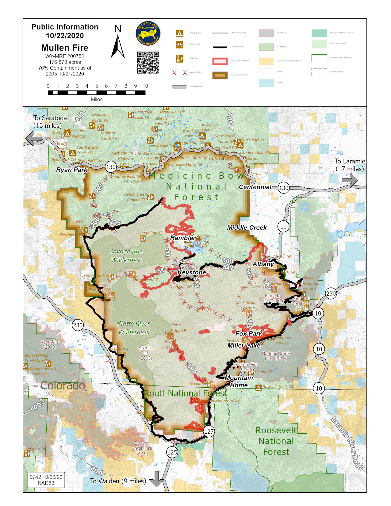
Mullen Fire Map as of 102420
Related Incident:
Publication Type: Announcement
The map has been updated based on infrared mapping that was done last evening (Friday October 23).
Current fire size: 176,878 acres
Containment: 85%
We don't anticipate any changes in these numbers for the foreseeable future.
Mullen Fire Daily Fact Sheet 102320
Related Incident:
Publication Type: News
Please note: This Fact Sheet is the last daily update in this format.
Location
The Mullen Fire is approximately 38 miles west of Laramie, Wyoming.
Size & Resources
Roughly 176,878 acres as of 10/22. Approximately 385 firefighters and support staff.
Containment
81% contained
Overview and Advisories
Smoke from burning stumps and other heavy fuels within the fire was more visible Thursday, particularly along highway corridors.
Because of the current cooling trend, fire behavior is expected to decrease for the next few days.
Approximately one mile of chipping and brushing remains to be completed along Forest Road 225.
Firefighters continue monitoring, mopping-up, removing equipment and repairing damage.
A National Forest area closure remains in place for much of the southern Snowy Range. Travelers on open roads and highways are asked to stay on roadways and not enter the forest.
For evacuation and closure area information, please refer to the Albany County Sheriff Facebook page: https://www.facebook.com/Albany-County-Sheriffs-Office-618424944997540/
Notices
Landowners with private lands affected or damaged by fire suppression activities are invited to submit questions or concerns about repair efforts to 2020.Mullen@firenet.gov. Please include your name, address, phone number, inquiry, question or concern. Email subject line: Private Land Suppression Repair.
Those requesting a permit to remove property on the Medicine Bow-Routt National Forests can email 2020.Mullen@firenet.gov. Please include your name, contact information, description and location of property. Email subject line: Personal Property Recovery Permits.
Fire Weather
Friday: Mostly cloudy and cool with a few showers. Highs 35-40. Winds from the southwest 15-25 mph.
Saturday: Cloudy, mild and windy in the morning, turning colder late with a chance of rain or snowfall. Highs 42-47. Winds from the north 20-30 mph.
Sunday: Record cold and snow accumulations of 4 to 6 inches. Highs: 15-20. Winds from the east 10-20 mph.
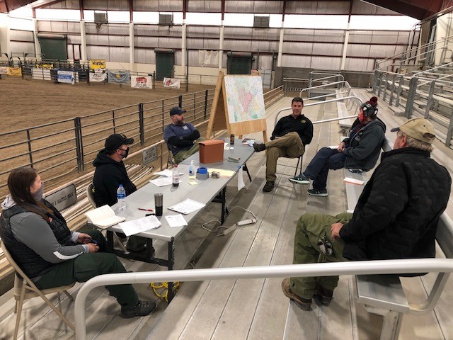
Meetings
Previously recorded sessions may be found here: https://www.facebook.com/MullenFire
Fire Cause
Under investigation. Call Laramie Ranger District anonymous tip line: (307) 745-2392
Closures
Road closures: https://www.wyoroad.info/pls/Browse/WRR.STATIC5?SelectedDistrict=1 and https://cotrip.org/home.htm
Medicine Bow-Routt National Forests: https://www.fs.usda.gov/detailfull/mbr/alerts-notices/?cid=stelprdb5139680&width=full (updated October 15)
Arapaho & Roosevelt National Forests: https://tinyurl.com/yxnxrnt2 (updated October 11)
BLM Emergency Area Closure: https://inciweb.nwcg.gov/incident/article/7208/57387/
General Fire Information
Email: 2020.Mullen@Firenet.gov
Inciweb: http://inciweb.nwcg.gov/incident/7208
Facebook: https://www.facebook.com/MullenFire, #MullenFire_WY
Twitter: Medicine Bow-Routt National Forests and Thunder Basin National Grassland @FS_MBRTB, #MullenFire_WY
Area residents are encouraged to help protect their homes from wildfires using tips from http://www.firewise.org
Mullen Fire Daily Fact Sheet 102220
Related Incident:
Publication Type: News
Location
The Mullen Fire is approximately 38 miles west of Laramie, Wyoming.
Size & Resources
Roughly 176,863 acres as of 10/21. Approximately 423 firefighters and support staff.
Containment
76% contained
Overview and Advisories
More smoke and open flames were visible on Wednesday due to higher temperatures and lower relative humidity. Residents in pre-evacuation areas will continue to see smoke and flames. The chance of fire growth is minimal-to-zero due to upcoming weather conditions.
Today personnel are monitoring the fire, mopping-up, removing equipment and repairing damage. Chipping and brushing operations continue in multiple areas of the fire.
Residents are asked to be alert for hazards near burned areas, including fire-weakened trees, smoldering or burning fuels, firefighting trucks and heavy equipment.
A National Forest area closure remains in place for much of the southern Snowy Range. The closure is being evaluated daily.
For evacuation and closure area information, please refer to the Albany County Sheriff Facebook page: https://www.facebook.com/Albany-County-Sheriffs-Office-618424944997540/
Notices
Landowners with private lands affected or damaged by fire suppression activities are invited to submit questions or concerns about repair efforts to 2020.Mullen@firenet.gov. Please include your name, address, phone number, inquiry, question or concern. Email subject line: Private Land Suppression Repair.
Those requesting a permit to remove property on the Medicine Bow-Routt National Forests can email 2020.Mullen@firenet.gov. Please include your name, contact information, description and location of property. Email subject line: Personal Property Recovery Permits.
Fire Weather
Thursday: Cloudy and turning colder with the chance of rain or snow showers, with accumulation of up to 2” possible. Highs 40-45. Winds from the north 15-25 mph.
Friday: Cloudy, cold and snow flurries. Highs 35-40. Winds from the north 15-25 mph. Only a few showers are likely.
Saturday: Cloudy with a chance of significant snowfall. Highs 41-47. Winds from the north 20-30.
Meetings
Previously recorded sessions may be found here: https://www.facebook.com/MullenFire
Fire Cause
Under investigation. Call Laramie Ranger District anonymous tip line: (307) 745-2392
Closures
Road closures: https://www.wyoroad.info/pls/Browse/WRR.STATIC5?SelectedDistrict=1 and https://cotrip.org/home.htm
Medicine Bow-Routt National Forests: https://www.fs.usda.gov/detailfull/mbr/alerts-notices/?cid=stelprdb5139680&width=full (updated October 15)
Arapaho & Roosevelt National Forests: https://tinyurl.com/yxnxrnt2 (updated October 11)
BLM Emergency Area Closure: https://inciweb.nwcg.gov/incident/article/7208/57387/
General Fire Information
Email: 2020.Mullen@Firenet.gov
Inciweb: http://inciweb.nwcg.gov/incident/7208
Facebook: https://www.facebook.com/MullenFire, #MullenFire_WY
Twitter: Medicine Bow-Routt National Forests and Thunder Basin National Grassland @FS_MBRTB, #MullenFire_WY
Area residents are encouraged to help protect their homes from wildfires using tips from http://www.firewise.org
Stage II Fire Restrictions for Routt National Forest
Related Incident:
Publication Type: News
Stage II fire restrictions emphasized by Routt National Forest and Sulphur Ranger District; Forest closure would be next step
(STEAMBOAT SPRINGS, Colo.) October 19, 2020 – Unprecedented wildfire activity and unsafe Forest conditions have prompted an inter-agency law enforcement effort to address fire restriction violations across multiple counties in northwest Colorado.
There will be a coordinated effort in the coming days and weeks between the USDA Forest Service - Routt and Arapaho National Forests; Garfield, Grand, Jackson, Moffat, Rio Blanco, and Routt counties; and Colorado Parks and Wildlife to aggressively enforce Stage II fire restrictions.
The appropriate level of fire restrictions will be re-evaluated daily as conditions change, and if necessary, the next step would be implementing Stage III restrictions, which would temporarily close all National Forest System lands to public activity.
Stage II fire restrictions currently apply to all Routt National Forest-managed lands located in Garfield, Grand, Jackson, Moffat, Rio Blanco, and Routt counties in northwest Colorado, as well as the Sulphur Ranger District on the Arapaho National Forest.
The following conditions are currently being experienced in the impacted counties:
Severe Drought
Extremely low fuel-moisture conditions
High occurrence of human-caused wildfires
Limited capacity for response to multiple wildfires
Persistent fire-danger weather conditions with no immediate relief forecast
“On-the-ground conditions are extreme and the current fire restrictions we have in place are not being respected,” said Russ Bacon, Forest Supervisor for the Medicine Bow-Routt National Forests and Thunder Basin National Grassland. “This law enforcement saturation effort with our partners is a final effort to avoid closing the Forest.
“Our ultimate intent is to protect public health and safety, as well as natural resources. Restricting public access to the National Forest would be our very last resort and we are hopeful that is not necessary with this coordinated push toward fire restriction compliance.”
Stage II fire restriction prohibitions can be found on both the Routt National Forest and Arapaho National Forest web sites. Restricted activities include the use of charcoal grills and barbecues, coal and wood burning stoves and sheepherder’s stoves and includes use in developed camping and picnic grounds. Wood burning stoves within wall tents are not exempted and are prohibited.
Violation of the fire restrictions is punishable as a class B misdemeanor, carrying a possible fine of up to $5,000 for an individual or $10,000 for an organization, imprisonment of not more than six months, or both. Anyone negligently or willfully starting a wildland fire could also be held responsible for the costs of that fire.
The Medicine Bow-Routt National Forests and Thunder Basin National Grassland entered Stage II fire restrictions on Aug. 20, 2020, after being at the Stage I level since July 3. The Sulphur Ranger District has been in Stage II restrictions since Oct. 8.
Both the Medicine Bow National Forest and Thunder Basin National Grassland in Wyoming remain in Stage II fire restrictions. Critical fire danger conditions still exist on many portions of those units.
Forest visitors should be aware of area closures that are in place for multiple extended-duration wildfires in the area.
Additional information may be found on our website or you can follow the Medicine Bow-Routt National Forests and Thunder Basin National Grassland on Twitter, @FS_MBRTB.
Mullen Fire Daily Fact Sheet 102020
Related Incident:
Publication Type: News
Location
The Mullen Fire is approximately 38 miles west of Laramie, Wyoming.
Size & Resources
Roughly 176,854 acres as of 10/19. Approximately 445 firefighters and support staff.
Evacuation Area Update
Related Incident:
Publication Type: Announcement
Evacuation Area Update
From the Albany County Sheriff’s Office
Effective 10/20/20 at 9:00 AM
The following areas will change from mandatory evacuation to pre-evacuation at the above date and time:
-Porter Ranch/Pelton Creek
-Fox Park
-Miller Lake
-Foxborough
-Dry Park
Those who own property in these areas will be allowed to access their private property only. As a reminder there is still a forest closure in place. Access to Porter Ranch/Pelton Creek, Fox Park, Miller Lake and Foxborough will be from the Highway 230 side. You will be required to stop and check in with the forest security prior to entering. Property owners in Dry Park can access the area through Albany on FS 500.
There are no longer any mandatory evacuation areas related to Mullen Fire. All previous pre-evacuation areas remain the same.