
Mullen Fire Daily Fact Sheet 101320
Related Incident:
Publication Type: News
Location
The Mullen Fire is approximately 28 miles west of Laramie, Wyoming.
Size & Resources
Roughly 176,213 acres as of 10/12, 11:35 pm. Approximately 1215 firefighters and support staff.
Containment
30% contained, on the western and southern edge up through Mountain Home area and a section northwest of Woods Landing.
Overview
Snowfall on the fire yesterday reduced fire activity and on the northern end slowed fire progression into the French Creek drainage. Larger fuels that only smoked in the morning began actively burning in the afternoon as fuels dried. Active fire developed around Albany and Fox Creek Road in the afternoon, but firefighters were able to keep it within established firelines.
Firefighters continue to work near Keystone, Rambler, Foxborough, and Fox Park. Structure protection remains in place.
Fireline has been established near the Middle Fork as a barrier to fire progression toward Centennial. As a precaution, structure protection in Centennial continues to be a priority.
Fire breaks have also been improved south of Ryan Park and the community conducted a cleanup of brush to help firefighters protect structures if needed. Structure protection supplies have been pre-positioned in Ryan Park as a precaution.
In some interior parts of the forest, fire is burning into the deep duff organic layer, creating holes. This type of fire will require a lot of moisture to extinguish.
Colorado Hwy 127 has reopened from Hwy 125 to the Wyoming state line for local residents. Residents along Hwy 127 can access their property but remain under a pre-evacuation order and need to be ready to evacuate quickly if conditions change. The power company is assessing this area to restore power. All other closures and evacuations remain.
Fire Weather
Tuesday: High Wind Watch after midnight. Winds out of the northwest at 15-25 mph with gusts up to 35 mph. Wind gusts up to 45 mph at higher elevations. Highs 50-55.
Wednesday: High Wind Warning. Strong winds will return with a cold front passage on Wednesday. Light precipitation possible. Winds out of the northwest 30-40 mph. Wind gusts 60-75 mph are possible. Highs 45-50.
Meetings
Virtual Community Q&A WEDNESDAY at 5 p.m.
Livestreamed on the Mullen Fire Information page https://www.facebook.com/MullenFire
Fire Cause
Under investigation. Call Laramie Ranger District anonymous tip line: (307) 745-2392
Closures
Road closures: https://www.wyoroad.info/pls/Browse/WRR.STATIC5?SelectedDistrict=1 and https://cotrip.org/home.htm
Medicine-Bow Routt National Forests: https://tinyurl.com/y4gb8bqs
Arapaho Roosevelt National Forests: https://tinyurl.com/y2e3qn3y
BLM Emergency Area Closure: https://inciweb.nwcg.gov/incident/article/7208/57387/
General Fire Information
Email: 2020.Mullen@Firenet.gov
Inciweb: http://inciweb.nwcg.gov/incident/7208
Facebook: https://www.facebook.com/MullenFire, #MullenFire_WY
Twitter: Medicine Bow-Routt National Forests and Thunder Basin National Grassland @FS_MBRTB, #MullenFire_WY
Public and firefighter safety is the number one priority.
Help protect your home from wildfires using tips from www.firewise.org.
Mullen Fire Daily Fact Sheet 101220
Related Incident:
Publication Type: News
Location
The Mullen Fire is approximately 28 miles west of Laramie, Wyoming.
Size & Resources
Roughly 175,564 acres as of 10/11, 12 pm. Approximately 1214 firefighters and support staff.
Containment
Overview
Precipitation on the fire yesterday reduced fire activity and spread; however, strong winds impacted the use of aircraft. Continued strong winds today will limit aircraft operations.
Fire on the north edge continues to progress slowly due to west winds. Structure protection supplies have been pre-positioned in Ryan Park, and the community conducted a cleanup of brush to help firefighters protect structures if needed.
Active fire continues around Albany, west of Keystone, and in the Foxborough and Fox Park areas. Firefighters continue to monitor hot spots near the southeast side of the fire perimeter, and structure protection remains in place in Keystone, Rambler, Albany, Foxborough, Mountain Home, and Fox Park.
Minimal fire progression toward Centennial is expected, but fire activity will increase as drier conditions return with southwesterly winds, warming temperatures, and lower humidity. Fire line has been established in the Middle Creek area between the fire and Centennial. As a precaution, structure protection in Centennial continues to be a high priority.
A Burned Area Emergency Response (BAER) team arrives today to begin assessment of damage to natural resources and prescribe emergency stabilization actions intended to reduce potential future damage from post-fire erosion, flooding, and debris flows.
Fire Weather
Monday: High wind warning. Winds out of the west at 25-35 mph with gusts up to 60 mph. Highs 45-50.
Tuesday: Wind out of the southwest 15-25 mph with gusts to 35 mph becoming west-southwest after noon. High in the 50s.
Meetings
Virtual Community Q&A TODAY at 5 p.m.
Livestreamed on the Mullen Fire Information page https://www.facebook.com/MullenFire
Fire Cause
Under investigation. Call Laramie Ranger District anonymous tip line, (307) 745-2392.
Closures
Road closures: https://www.wyoroad.info/pls/Browse/WRR.STATIC5?SelectedDistrict=1 and https://cotrip.org/home.htm
Medicine-Bow Routt National Forests: https://tinyurl.com/y4gb8bqs
Arapaho Roosevelt National Forests: https://tinyurl.com/y2e3qn3y
BLM Emergency Area Closure: https://inciweb.nwcg.gov/incident/article/7208/57387/
General Fire Information
Email: 2020.Mullen@Firenet.gov
Inciweb: http://inciweb.nwcg.gov/incident/7208
Facebook: https://www.facebook.com/MullenFire/, #MullenFire_WY
Twitter: Medicine Bow-Routt National Forests and Thunder Basin National Grassland @FS_MBRTB, #MullenFire_WY
Public and firefighter safety is the number one priority.
Help protect your home from wildfires using tips from www.firewise.org.
Mullen Fire Daily Fact Sheet 101120
Related Incident:
Publication Type: News
Location
The Mullen Fire is approximately 38 miles west of Laramie, Wyoming.
Size & Resources
Roughly 175,535 acres as of 10/10, 3 pm. Approximately 1224 firefighters and support staff.
Containment
25% contained, mostly along the western edge and down around the Colorado portion of the fire, and a piece to the northwest of Woods Landing.
Overview
Containment has increased on the western edge down around the Colorado portion of the fire.
Fire on the north edge continues to progress slowly due to northwest winds. On the southeast side, firefighters are prepared for spot fires. Firefighters are prioritizing control of fire spread in the finger at Woods Landing. Winds today may impact the availability of aircraft.
Active fire continues north of Albany. Bulldozers and aerial retardant have created a line between the fire edge and Centennial to keep the fire in check to the Middle Creek area. Fire progression towards Centennial is not expected but firefighters are getting structure protection ready as a fallback measure in case winds shift. Structure protection is also being prepared for Ryan Park. The community cleanup of brush will help firefighters protect structures.
Structure protection continues in the Rambler and Keystone areas. The fire has not moved much around Rambler. Most of the fire’s growth yesterday was west of Keystone where the pocket of unburned forest is expected to close over the next day or so.
Hwy 10 has reopened and the mandatory evacuation along Hwy 10 has been changed to pre-evacuation. This includes Woods Landing and Jelm south to Colorado. Residents of that area can access their property but need to remain ready to evacuate quickly if conditions change. The power company is assessing this area to restore power. Hwy 230 remains closed westbound near Woods Landing. Boswell Creek Road is closed where it enters National Forest. All other closures and evacuations remain.
Fire Weather
Sunday: High wind warning. Cold front comes through in the morning bringing light precipitation, changing over to snow. Winds out of the west increasing and switching out of the northwest with gusts of 45 to 55 mph. High in the 40s. 0.5 to 2 inches of snow on fire area. 0.1” to 0.25” of liquid precipitation.
Monday: Wind out of the southwest 25-35 mph with gusts to 50 mph becoming west-southwest after noon. High in the 50s.
Meetings
Virtual Community Q&A TODAY at 5 p.m.
Livestreamed on the Mullen Fire Information page (https://www.facebook.com/MullenFire)
Fire Cause
Under investigation. Call Laramie Ranger District anonymous tip line, (307) 745-2392.
Closures
Road closures: https://www.wyoroad.info/pls/Browse/WRR.STATIC5?SelectedDistrict=1 and https://cotrip.org/home.htm
Medicine-Bow Routt National Forests: https://tinyurl.com/y4gb8bqs
Arapaho Roosevelt National Forests: https://tinyurl.com/y2e3qn3y
BLM Emergency Area Closure: https://inciweb.nwcg.gov/incident/article/7208/57387/
General Fire Information
Email: 2020.Mullen@Firenet.gov
Inciweb: http://inciweb.nwcg.gov/incident/7208
Facebook: https://www.facebook.com/MullenFire/, #MullenFire_WY
Twitter: Medicine Bow-Routt National Forests and Thunder Basin National Grassland @FS_MBRTB, #MullenFire_WY
Public and firefighter safety is the number one priority.
Help protect your home from wildfires using tips from www.firewise.org.Evacuation status change for residents living along Hwy 127 in Colorado
Related Incident:
Publication Type: News
From Jackson County Colorado Sheriff: change in evacuation status for residents living along Hwy 127 in Colorado. There has been no change to the status of Highway 230 from the state line to Woods Landing in Wyoming.
To clear up any confusion on the opening of Highway 127 please read on....
As of 10.10.20 @ 6:00 p.m. the evacuation order has been lifted for residents who live on Highway 127. However, pre-evacuation order is STILL in effect and we ask everyone who returns home to still be prepared to evacuate again. The fire can still easily spot into unburnt vegetation.
Highway 127 is open only for residents returning home and not for any recreational activities.
Frequently Asked Questions Glossary of Terms
Related Incident:
Publication Type: Announcement
1. How do you determine if a line is contained?
A: A fire is considered contained when it is stopped from spreading by a fuel break and firefighters are confident the fire will not cross this perimeter. The fuel break could be a line cleared down to bare ground by firefighters, a natural feature like a stream, or another feature like a road or trail. The fire inside the containment line may still be actively burning and may even jump the line if embers are carried across by strong winds. A fire isn’t controlled until little to no heat remains within the fire perimeter, and the fire poses no threat to crossing containment lines.
2. How far is the line from my location?
A: To see how far a location is from the fire perimeter, please visit the Mullen Fire Interactive Story Map and use the “ruler tool.”
3. What are the chances the Mullen Fire and Cameron Peak Fire would combine?
A: While possible, the chances of the Mullen Fire combining with the Cameron Peak Fire are slim. Although the Mullen Fire crossed the state line and entered Colorado, the two fires are currently over 26 miles apart. The southern boundary of the Mullen Fire has been holding along highway 230 for over a week, and would need to cross this perimeter and work through multiple contingency plans to reach Cameron Peak.
4. When may I check on my property?
A: You may check on your property when the full evacuation order has been lifted by local authorities. Even though there may be limited fire activity in your area, hazards from the recent fire remain. Threats may exist that are not immediately or easily noticed. Hazard trees that have weakened trunks and root systems are a common danger, as are compromised electrical infrastructure such as lines and poles. Until those threats have been mitigated, infrastructure and utilities secured, and emergency services have approved the return, it is safest for the public to stay out of the closed area.
5. What is a BAER Team?
A: BAER (Burned Area Emergency Response) teams rapidly assess the damage to natural resources caused by large wildfires. These specially trained professionals then prescribe emergency stabilization actions intended to reduce potential future damage from post-fire erosion, flooding, and debris flows. Team members include hydrologists, soil scientists, engineers, biologists, and other natural resource specialists.
6. I want to donate something. How can I do that?
A: We appreciate the generosity of this community and recommend that you direct your donations to residents who were affected by the wildfire. Local organizations such as volunteer fire departments and the Red Cross can put your donations to the best use. Incident management teams and the firefighters associated with them are well supplied and cannot accept food or other donations. However, firefighters enjoy seeing signs posted in the community and receiving letters and drawings from kids.
7. How is the Mullen Fire impacting the wildlife?
A: Wildlife and fire have coexisted for hundreds of years. Most forest animals can sense danger and will flee the threat, running or flying away or even standing in streams to avoid a fire. Some animals will unfortunately perish in the fire, usually the elderly or the youngest, which are unable to move as fast. Fire is a part of the natural ecosystem and small, healthy fires help species by providing ash to enrich the soil, allowing sunlight to reach the forest floor and grow new forage, and removing dead and diseased trees and plants.
8. Is the interior of the fire still burning?
A: Yes, there are many areas within the overall fire perimeter that are still actively burning. Wildfires routinely burn in a mosaic pattern across the landscape, leaving unburned fuel within the fire perimeter. Often, these zones will continue burning over time and can produce large amounts of smoke.
9. What is being done to protect the structures within the fire boundary?
A: Structures well within the fire perimeter have generally been prepared for or protected from the main fire by structural fire crews if there was time to do so safely. Once the main threat is over and the majority of the heat has cooled, those firefighters move to the next structure and there is continued monitoring of the others. Crews will return to check on structures as needed until the threat is gone.
10. How will I be notified if I need to evacuate?
A: Your local county sheriff will contact residents with any pre-evacuation notices and again if an evacuation is required. Some counties utilize a reverse 911 system to notify you by phone or text. Please contact your local county sheriff’s office to find out their preferred means of communication.
11. Do the red designated areas mean that everything in that area burned?
A: No. Some of the areas that are shown in red may contain smaller pockets of unburned fuels. Our maps span large areas of land making it impossible to see these detailed areas. Also, there are varying degrees of burn severity/intensity. Even if the entire ground surface has burned it could have been a low intensity burn that consumed only the grass and brush component and left the trees largely intact and living.
12. I have noticed no aircraft is flying. Are you still fighting the fire?
A: Yes, we are still fighting the fire. Aerial resources can only be used when there is appropriate visibility at both the work site and at the airport or heli-spot. Firefighters are constantly working on the ground fighting the fire or monitoring the situation. Firefighters are significantly more efficient with the availability of water and retardant provided by aircraft. However, aerial support alone will not put out a fire. Firefighters on the ground are needed to effectively extinguish a fire.
13. Why isn’t the National Guard fighting the fire?
A: The Wyoming Army National Guard is being utilized to support firefighting efforts. The fire organization is using their facilities in Laramie as an Incident Command Post. Wildland firefighting requires specialized qualifications and training due to the inherent risk of firefighting activities. Most National Guard units have not been trained for this type of work an cannot be utilized in this capacity. The Wyoming National Guard has volunteered the services to the fire organization and we will utilize these skills as opportunities present themselves.
Glossary of Terms
-
Bambi Bucket: A collapsible bucket slung below a helicopter. Used to dip water from a variety of sources for fire suppression.
-
Bucket Drops: The dropping of fire retardants or suppressants from specially designed buckets slung below a helicopter.
-
Contain a fire: A fuel break around the fire has been completed. This break may include natural barriers or manually and/or mechanically constructed line.
-
Control a fire: The complete extinguishment of a fire, including spot fires. Fireline has been strengthened so that flare-ups from within the perimeter of the fire will not break through this line.
-
Cold Trailing: A method of controlling a partly dead fire edge by carefully inspecting and feeling with the hand for heat to detect any fire, digging out every live spot, and trenching any live edge.
-
Chain: A unit of linear measurement equal to 66 feet.
-
Defensible Space: An area either natural or manmade where material capable of causing a fire to spread has been treated, cleared, reduced, or changed to act as a barrier between an advancing wildland fire and the loss to life, property, or resources. In practice, "defensible space" is defined as an area a minimum of 30 feet around a structure that is cleared of flammable brush or vegetation.
-
Direct Attack: Any treatment of burning fuel, such as by wetting, smothering, or chemically quenching the fire or by physically separating burning from unburned fuel.
-
Fire Line: A linear fire barrier that is scraped or dug to mineral soil.
-
Flanks of a Fire: The parts of a fire's perimeter that are roughly parallel to the main direction of spread.
-
Fuel: Combustible material. Includes, vegetation, such as grass, leaves, ground litter, plants, shrubs and trees, that feed a fire. (See Surface Fuels.)
-
Surface Fuels: Loose surface litter on the soil surface, normally consisting of fallen leaves or needles, twigs, bark, cones, and small branches that have not yet decayed enough to lose their identity; also grasses, forbs, low and medium shrubs, tree seedlings, heavier branchwood, downed logs, and stumps interspersed with or partially replacing the litter.
-
Fine (Light) Fuels: Fast-drying fuels, generally with a comparatively high surface area-to-volume ratio, which are less than 1/4-inch in diameter and have a timelag of one hour or less. These fuels readily ignite and are rapidly consumed by fire when dry.
-
Heavy Fuels: Fuels of large diameter such as snags, logs, large limb wood, that ignite and are consumed more slowly than flash fuels.
-
Ladder Fuels: Fuels which provide vertical continuity between strata, thereby allowing fire to carry from surface fuels into the crowns of trees or shrubs with relative ease. They help initiate and assure the continuation of crowning.
-
Mop-up: To make a fire safe or reduce residual smoke after the fire has been controlled by extinguishing or removing burning material along or near the control line, felling snags, or moving logs so they won't roll downhill.
-
Snag: A standing dead tree or part of a dead tree from which at least the smaller branches have fallen.
-
Spot Fire: A fire ignited outside the perimeter of the main fire by flying sparks or embers.
Sources (Links contain complete list of terms)
Mullen Fire Daily Fact Sheet 101020
Related Incident:
Publication Type: News
Location
The Mullen Fire is approximately 38 miles west of Laramie, Wyoming.
Size & Resources
Roughly 174,911 acres as of 11:30 pm 10/9. Approximately 1254 firefighters and support staff.
Containment
21% contained, mostly along the west portion of Hwy 230 in the Platte River Valley in Wyoming, Hwy 125 and Hwy 127 in Colorado, and a piece to the west of Woods Landing.
Overview
Containment has increased on the western edge and more containment is expected in the next 72 hours in the southeast area of the fire along WY Hwy 230 and CO Hwy 127. On the north side, crews are using roads and trails as indirect line to catch the spread of the fire.
Firefighters continue to look for opportunities to cut off fire activity north of Albany; slow progression is expected towards Centennial where structure protection continues. Firefighters are also focused on containing the finger above Woods Landing.
Air resources will continue to provide support with water and retardant drops. Firefighters remain in the area 24 hours a day to perform patrols and structure protection.
Hwy 10 has reopened and the mandatory evacuation along Hwy 10 has been changed to pre-evacuation. This includes Woods Landing and Jelm south to Colorado. Residents of that area can access their property but need to remain ready to evacuate quickly if conditions change. The power company is assessing this area to restore power. Hwy 230 remains closed westbound near Woods Landing. Boswell Creek Road is closed where it enters National Forest. All other closures and evacuations remain.
Fire Weather
Saturday: Red Flag Warning from 12:00 pm to 8:00 pm. Warm, dry, and windy. High 60 degrees. South winds until 10 am, becoming SW 13-18 mph, gusting to 35 mph after 1:00 pm. Minimum RH 16-20%.
Sunday: Colder and very windy with gusts of 45 to 55 mph. High 40 degrees. Mixed precipitation in upper elevations from 9:00 am to 2:00 pm. 0.1” to 0.2” of liquid precipitation, lowest on the southern end of fire.
Monday: Cold and windy. Isolated mixed precipitation early in the day. High in the low 40s. Winds out of the WSW 15-25 mph, gusting to 45 mph.
Meetings
Virtual Community Q&A TODAY at 5 p.m.
Livestreamed on the Mullen Fire Information page (https://www.facebook.com/MullenFire)
Fire Cause
Under investigation. Call Laramie Ranger District anonymous tip line, (307) 745-2392.
Closures
Road closures: https://www.wyoroad.info/pls/Browse/WRR.STATIC5?SelectedDistrict=1 and https://cotrip.org/home.htm
Medicine-Bow Routt National Forests: https://tinyurl.com/y4gb8bqs
Arapaho Roosevelt National Forests: https://tinyurl.com/y2e3qn3y
BLM Emergency Area Closure: https://inciweb.nwcg.gov/incident/article/7208/57387/
General Fire Information
Email: 2020.Mullen@Firenet.gov
Inciweb: http://inciweb.nwcg.gov/incident/7208
Facebook: https://www.facebook.com/MullenFire/, #MullenFire_WY
Twitter: Medicine Bow-Routt National Forests and Thunder Basin National Grassland @FS_MBRTB, #MullenFire_WY
Public and firefighter safety is the number one priority.
Help protect your home from wildfires using tips from www.firewise.org.
Mullen Fire Daily Fact Sheet 10920
Related Incident:
Publication Type: News
Location
The Mullen Fire is approximately 38 miles west of Laramie, Wyoming.
Size & Resources
Roughly 173,747 acres as of 9:55 pm 10/8. Approximately 1186 firefighters and support staff.
Containment
18% contained, mostly along the west portion of Hwy 230 in the Platte River Valley in Wyoming, Hwy 125 and Hwy 127 in Colorado, and a piece to the west of Woods Landing.
Overview
Fire is slowly progressing to the north and northwest due to heavy load of dead and down fuels and firefighters will use French Creek Canyon as a natural containment line. Along the western boundary containment is increasing. There is some heat near Camp Creek but none north of the A-A Ranch to the northwest point of the fire. On the south end pockets continue to burn together with little spotting. Near Mountain Home fire continues slight movement except in recent timber sale areas. At Fox Park fire is slowly eliminating fuels reducing potential for reburn.
Firefighters are focusing on containing the finger above Woods Landing. From Albany north, fire in grass is more easily controlled but slow progression is expected towards Centennial where structure protection continues. Air resources have dropped thousands of gallons of water and retardant.
The mandatory evacuation along Hwy 10 has been changed to pre-evacuation. This includes Woods Landing and Jelm south to Colorado. Residents of that area can access their property but need to remain ready to evacuate quickly if conditions change. The power company is assessing this area to restore power. Hwy 230 remains closed westbound near Woods Landing. Boswell Creek Road is closed where it enters National Forest. All other closures and evacuations remain.
Fire Weather
Friday: Very dry and continued warm with high 62-68 degrees. West winds of 10-15 mph, gusting to 25 mph. Minimum relative humidity (RH) 14-19%.
Saturday: Warm, dry, and windy. High 60-66 degrees. South winds until 10 am, becoming SW 13-18 mph, gusting to 35 mph after 1 pm. Minimum RH 17-22%.
Sunday: Colder and very windy with gusts of 45 to 55 mph. Mixed precipitation in upper elevations from morning into evening.
Meetings
Virtual Community Q&A TODAY at 5 p.m.
Livestreamed on the Mullen Fire Information page (https://www.facebook.com/MullenFire)
Fire Cause
Under investigation. Call Laramie Ranger District anonymous tip line, (307) 745-2392.
Closures
Road closures: https://www.wyoroad.info/pls/Browse/WRR.STATIC5?SelectedDistrict=1 and https://cotrip.org/home.htm
Medicine-Bow Routt National Forests: https://tinyurl.com/y4gb8bqs
Arapaho Roosevelt National Forests: https://tinyurl.com/y2e3qn3y
BLM Emergency Area Closure: https://inciweb.nwcg.gov/incident/article/7208/57387/
General Fire Information
Email: 2020.Mullen@Firenet.gov
Inciweb: http://inciweb.nwcg.gov/incident/7208
Facebook: https://www.facebook.com/MullenFire/, #MullenFire_WY
Twitter: Medicine Bow-Routt National Forests and Thunder Basin National Grassland @FS_MBRTB, #MullenFire_WY
Public and firefighter safety is the number one priority.
Help protect your home from wildfires using tips from www.firewise.org.
Mullen Fire Evacuation Update 1045 am 1092020
Related Incident:
Publication Type: News
The following area has been changed from mandatory evacuation to pre-evacuation:
-Everything along highway 10 to include Woods Landing and Jelm south to the Colorado state line Residents of that area will now be able to access their property and residences but need to remain ready to evacuate quickly if the status changes. The power company is doing assessments in this area in order to restore power. Highway 230 will remain closed to westbound traffic near Woods Landing and Boswell Creek Road will be closed where it enters National Forest. All other closures and evacuations areas remain the same.
Highway 10 changed to preevacuation 1045 am 1092020
Related Incident:
Publication Type: Announcement
Evacuation Area Update:
The Albany County Sheriff's Office has announced a change in the evacuation status of the Highway 10 corridor. The following area has been changed from mandatory evacuation to pre-evacuation:-Everything along highway 10 to include Woods Landing and Jelm south to the Colorado state line Residents of that area will now be able to access their property and residences but need to remain ready to evacuate quickly if the status changes. The power company is doing assessments in this area in order to restore power. Highway 230 will remain closed to westbound traffic near Woods Landing and Boswell Creek Road will be closed where it enters National Forest. All other closures and evacuations areas remain the same.
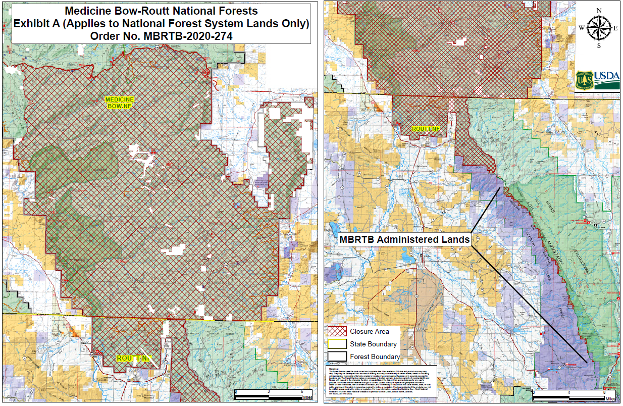
MBRTB Closure Order MBRTB2020274
Related Incident:
Publication Type: Closures
Medicine Bow-Routt National Forests and Thunder Basin National Grassland (MBRTB) fire area closure as of October 1, 2020. View the fire area closure order and closure map (click link to view).