
Medicine BowRoutt National Forests fire restrictions extended to Oct 31
Related Incident:
Publication Type: Announcement
Stage II fire restrictions have been updated to extend through October 31, 2020.
Midday operations update
Related Incident:
Publication Type: Announcement
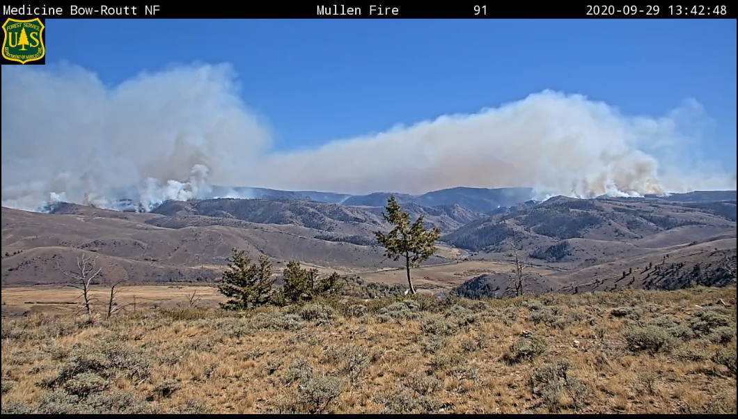
This afternoon, fire activity has increased in several areas of the Mullen Fire. Heavy helicopters are making bucket drops on the west flank. On the east side, part of the fire is moving into the area recently burned by the Badger Creek Fire. More firefighting resources continue to join the firefighting effort. Over the past two days 70 more engines have arrived.
Our interactive Story Map (https://arcg.is/1mnyXL) shows the latest fire perimeter, and includes features to look up an address or measure the distance between your home and the fire.
Morning operations update
Related Incident:
Publication Type: Announcement
Good morning, the Mullen Fire is now 82,649 acres, based on an infrared measurement just before midnight. Firefighters worked through the night to aggressively defend structures.
Our interactive Story Map (https://arcg.is/1mnyXL) shows the latest perimeter, and includes features to look up an address or measure the distance between your home and the fire.
Albany County lifts evacuation Hwy 230 from Meadow Plains to Lake Hattie
Related Incident:
Publication Type: Announcement
Important announcement from the Albany County Sheriff's Office
The evacuated areas west of Hwy 230 from Meadow Plains Road, east towards Sodergreen Lake to Lake Hattie has been lifted. Everything including Meadow Plains Road south west towards Woods landing remains evacuated.
Hwy 230 will be closed westbound at the intersection of Meadow Plains Road. Sheriff’s Deputies will be in the area.
We appreciate everyone’s patience during this difficult time.
Air operations back in the air Monday 928
Related Incident:
Publication Type: News
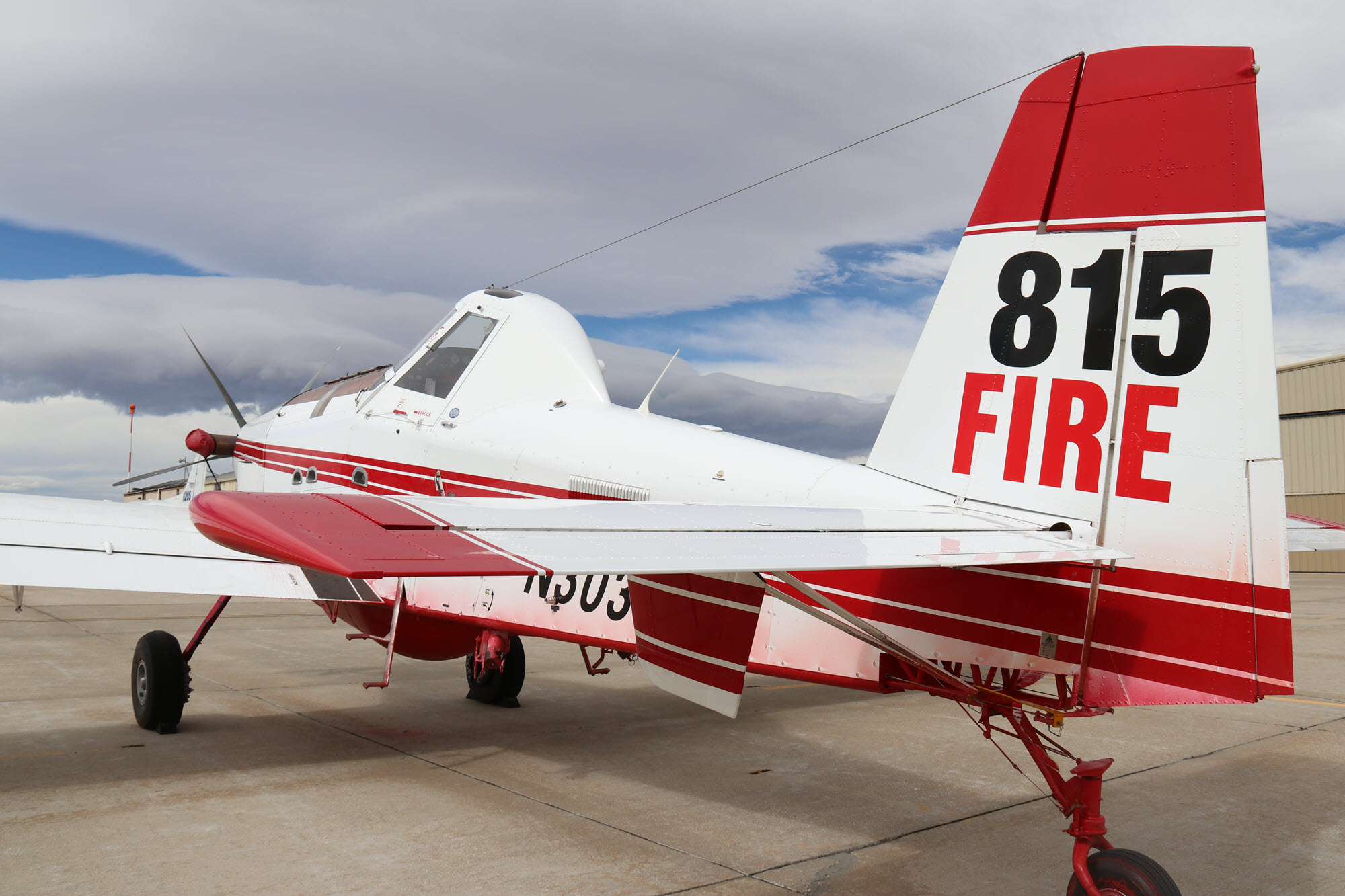
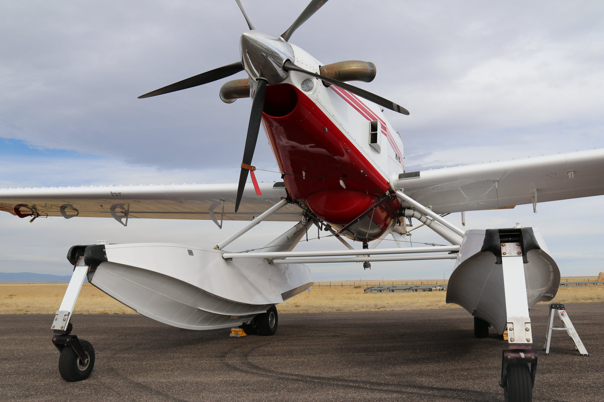
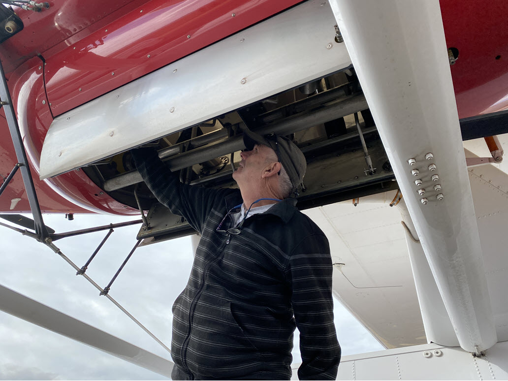
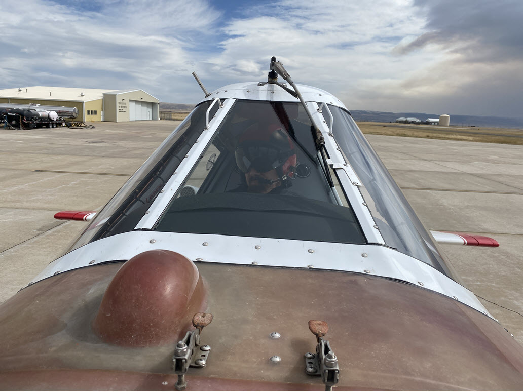
After two days of adverse weather that kept our aircraft on the ground, air operations was back at work on Monday. Pilots were eager to get back into the air, but first needed to de-ice their aircraft after last night’s freezing temperatures – a safety step not usually required on a summer wildfire.
The two planes shown in the attached photos are a Single Engine Air Tanker (SEAT) and its aquatic cousin, often called a “fire boss.” The Mullen Fire’s air fleet includes four of each type of SEAT, along with multiple helicopters, large “super scoopers,” and fixed-wing planes for our Air Attack supervisors. Because so many aircraft are assigned to this fire, the Wyoming Air National Guard is available to support other fires.
Single Engine Air Tankers (SEATs) are nimble aircraft well suited to mountainous terrain. They can carry up to 800 gallons of water or retardant at low altitudes, but at this high altitude they carry less. On this fire, they need only a short time to refill and return to the fire. Our SEATs refill at Laramie, and the fire boss aircraft are scooping water from Rob Roy Reservoir.
A Single Engine Air Tanker (SEAT) with floats is commonly called a "small scooper" or "fire boss." It races across the surface of a lake or reservoir to fill its 800-gallon tank, which is in the body of the plane - the floats are empty. Pilots find that the floats get the least resistance when the water surface is not too smooth... not too choppy... but just right.
Mullen Fire Daily Update for 9292020
Related Incident:
Publication Type: News
Virtual Community Q&A TODAY at 5 p.m.
The meeting will be livestreamed on the Mullen Fire Information page (https://www.facebook.com/MullenFire)
Summary: Crews worked yesterday on structure protection in multiple communities, which included both developed areas close to the fire’s perimeter and those a few miles further to the south and west. Air operations played a big role in tactics after two days of waiting for reduced wind speeds to return to the skies. Today, they use retardant to strategically pre-treat areas adjacent to values at risk.
Firefighters prioritized assessing properties for any damaged or destroyed buildings. They shared their findings with the Albany County Sheriff’s Office who took the lead on directly contacting affected homeowners.
Additional crews have been reassigned to the Mullen Fire after being released from fires in the Pacific Northwest. This allows previously unstaffed areas of the fire to be more closely monitored or to be scouted for possible construction of indirect fire line.
Crews will also be conducting fire severity assessments. Often fires will burn in a mosaic pattern, leaving pockets of both burned and unburned fuels. However, when a fire with high intensity quickly moves through an area, it may leave larger swaths of blackened soil and vegetation. This factors into any whether any stabilization or rehabilitation may be needed at a later date.
No containment will be declared until heat near the perimeter has been deemed unlikely to grow beyond any established fire line. This involves monitoring the fire line and adjacent areas for several days for smoldering stumps or trees, ash pits, or any other heat sources.
Fire Conditions and Weather: Warmer temperatures are expected to return to the area along with a dry air mass. The combination of low humidity and gusting winds will result in near-critical fire weather conditions. Increased fire activity is likely the next several days; extreme fire behavior is possible.
Mandatory Evacuations: Multiple evacuations and pre-evacuations are in place. See the Albany County Sheriff Office’s Facebook Page or Albany County website for the latest list: https://www.facebook.com/Albany-County-Sheriffs-Office-618424944997540 or https://www.co.albany.wy.us/
Road Closures: WY 11 from the junction with County Road 47 (Fox Creek Road.) into Albany. County Road 47 between WYO 11 and WYO 230. WY 230 from the CO border to Meadow Plains Road. WYO 10 from WYO 230 to the CO state line. There is no estimate on when these roads might reopen.
Forest Closure: In effect surrounding the Mullen Fire. For details, see the new Forest Closure Order https://tinyurl.com/yyanh6ey and the new Forest Closure Area Map https://tinyurl.com/y3wh7bv3
Forest and County Stage 2 Fire Restrictions:
- Medicine Bow-Routt National Forests and Thunder Basin National Grassland: https://www.fs.usda.gov/Internet/FSE_DOCUMENTS/fseprd786902.pdf
- Albany County: https://www.co.albany.wy.us/247/Fire-Restrictions
Temporary Flight Restriction: In effect for the fire area: https://tinyurl.com/y3foyxwt
New morning acreage
Related Incident:
Publication Type: News
The
Our interactive Story Map (https://arcg.is/1mnyXL) shows the latest perimeter, and includes features to look up an address or measure the distance between your home and the fire.
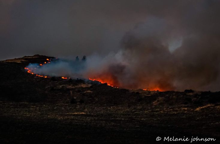
Photo by Melanie Johnson
Evening operations update
Related Incident:
Publication Type: Announcement
The
Printable maps are not ready this evening, but our interactive Story Map (https://arcg.is/1mnyXL) shows the latest perimeter, and includes features to look up an address or measure the distance between your home and the fire.
Mullen Fire Daily Update for 9282020
Related Incident:
Publication Type: News
Virtual Community Q&A TODAY at 5 p.m.
The meeting will be livestreamed on the Mullen Fire Information page (https://www.facebook.com/MullenFire)
Summary
Cooler, cloudy weather and less erratic fire behavior allowed firefighters to return to the southeast end of the fire yesterday to resume structure defense actions and to assess properties in impacted areas including Lower Keystone, Lake Creek, and Foxborough. Next, they will forward their assessments to the Albany County Sheriff’s Office who will directly contact homeowners if notifications are necessary. The Sheriff’s Office will announce when that process is concluded.
Today, crews will continue structure protection work in communities south of the fire. Firefighters will also work the area where the fire crossed Highway 230 south of Woods Landing. They will use the highway as an anchor point to tie fireline into the area burned by the Badger Creek Fire (2017). Other areas of focus will be the 543 Road south of Rob Roy Reservoir and securing possible advance to the Sheep Mountain area.
Fire crews have multiple planes and helicopters on site to assist with suppression efforts, though strong winds and low cloud ceilings have limited their use the last two days. Those aerial resources may be utilized today under more favorable weather conditions.
Fire Conditions and Weather
A cold front moved into the area yesterday, bringing cooler temperatures, cloud cover, and higher humidity. Some light precipitation fell on portions of the fire. The incoming front shifted winds. This northwest wind pattern is expected to continue throughout the week along with a drying trend and increased temperatures. Critical to near-critical fire weather is expected for the next few days.
Mandatory Evacuations
See the Albany County Sheriff FB page for the latest list: https://www.facebook.com/Albany-County-Sheriffs-Office-618424944997540
- East of HWY 11 along Sheep Mountain, from Fox Creek Road, North to Hecht Creek.
- The communities of Lake Creek, Rambler, Rob Roy area, Wold, Beehive, Pelton Creek, Mountain Home, Graham, Fox Park, Foxborough, Albany, Woods Landing and adjacent areas.
- EVERYTHING along HWY 10 to the Colorado State Line.
- Areas near Sheep Mountain to Lake Hattie Reservoir and NORTH of HWY230.
- Fox Creek Road, including areas west of HWY 11 south of the Middle Fork Canyon.
- Keystone Communities: Keystone Proper, Lower Keystone, Langford/Ricker, Moore’s Gulch, 507C Cabin grouping.
Closures and Restrictions
Wyoming 11 is closed from the junction with County Road 47 into Albany. Wyoming 230 is closed from the Colorado border to Sodergreen Lake. County Road 47 (Fox Creek Road) is closed between WYO 11 and WYO 230. WYO 10 is closed from WYO 230 to the Colorado state line. There is no estimate on when these roads might reopen.
Forest Closure
A Forest area closure is in effect surrounding the Mullen Fire. For details, see the new Forest Closure Order https://tinyurl.com/yyanh6ey and the new Forest Closure Area Map https://tinyurl.com/y3wh7bv3
Stage 2 Fire Restrictions in Effect for the Fire Area
- Medicine Bow-Routt National Forests and Thunder Basin National Grassland: https://www.fs.usda.gov/Internet/FSE_DOCUMENTS/fseprd786902.pdf
- Albany County: https://www.co.albany.wy.us/247/Fire-Restrictions
A Temporary Flight Restriction is in effect for the fire area: https://tinyurl.com/y3foyxwt
Mullen Fire Daily Update for 9272020
Related Incident:
Publication Type: News
Virtual Community Q&A TODAY at 5 p.m.
The meeting will be livestreamed on the Mullen Fire Information page (https://www.facebook.com/MullenFire)
Summary
Yesterday, facing extreme fire behavior, firefighters again held the fire outside the Rambler community and kept it from advancing further toward Rob Roy Reservoir. On the southwest flank, fire extended a short distance over the North Platte River, and firefighters promptly began working to prevent more growth. On the northeast, fire crossed the Fox Creek road and moved into the Squirrel Burn area, prompting another Forest closure.
The lower portion of the fire continued pushing beyond Lake Owen to Fox Creek Road. The leading edge slowed as it entered a previously burned area, then crossed WY 230 in a position to threaten Woods Landing and Jelm. With wind gusts reaching 70 mph at times, fire managers recommended a mandatory evacuation of multiple communities in Albany County. (See list below.)
Today, firefighters focus on protecting structures in two ways. Ahead of the fire, they are assessing and preparing structures for the possible advance of the fire as the wind shifts and the fire moves to the southeast. Behind the flaming front, firefighters are entering communities as quickly as possible to perform structure protection actions. Damage assessment information is not yet available. Aerial support will continue as weather conditions allow. Task Forces of additional firefighters from multiple Wyoming fire departments have arrived to assist crews.
Fire Conditions and Weather
Gusty winds will shift to come from the northwest as a cold front passes. A few scattered light snow showers may occur, but are not expected to bring much moisture. Fire activity will remain extreme.
Mandatory Evacuations
See the Albany County Sheriff FB page for the latest list at: https://www.facebook.com/Albany-County-Sheriffs-Office-618424944997540
East of HWY 11 along Sheep Mountain, from Fox Creek Road, North to Hecht Creek. The communities of Lake Creek, Rambler, Rob Roy area, Wold, Beehive, Pelton Creek Mountain Home, Graham and adjacent areas, Fox Park, Foxborough, Albany, Woods Landing. EVERYTHING along HWY 10 to the Colorado State Line.
Areas near Sheep Landing to Lake Hattie Reservoir and NORTH of HWY230. Fox Creek Road including areas west of HWY 11 south of the Middle Fork Canyon. Keystone Communities: Keystone Proper, Lower Keystone, Langford/Ricker, Moore’s Gulch, 507C Cabin grouping
- Centennial remains on pre-evacuation
Wyoming 11 is closed between Wyoming 130 and Albany. Wyoming 230 is closed from Wyoming 10 to the Colorado border. There is no estimate on when these roads might reopen.
Forest Closure
A Forest area closure is in effect surrounding the Mullen Fire. For details, see the new Forest Closure Order (https://inciweb.nwcg.gov/photos/WYMBF/2020-09-17-1921-Savage-Run-Fire/related_files/pict20200825-175313-0.pdf) and the new Forest Closure Area Map (https://inciweb.nwcg.gov/photos/WYMBF/2020-09-17-1921-Savage-Run-Fire/related_files/pict20200825-175227-0.pdf) Stage 2 Fire Restrictions are in effect for the fire area
- Medicine Bow-Routt National Forests and Thunder Basin National Grassland: https://www.fs.usda.gov/Internet/FSE_DOCUMENTS/fseprd786902.pdf
- Albany County: https://www.co.albany.wy.us/247/Fire-Restrictions