
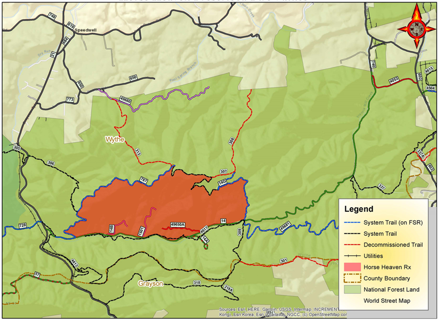
Prescribed Burn in the Horse Heaven area Wythe County
Related Incident:
Publication Type: News
Location: The 1,098-acre Horse Heaven prescribed burn is located three miles south of Speedwell and east of U.S. Route 21. The prescribed fire area is adjacent to and north of Forest Road 14.
Date and Time: The Forest Service plans to begin ignitions the week of April 6th, 2021, weather conditions permitting. Burning is expected to occur over one to two days. Firefighters will continue to monitor the area for several days after the burn.
Objective: Prescribed burns improve wildlife habitat by restoring open woodlands and grasslands to the forest landscape. Prescribed burns also keep the public and homes safe by reducing the buildup of dried leaves and wood in nearby forest land that can lead to uncontrolled wildfires.
Temporary Closures: The Virginia Highlands Horse Trail (Trail # 337) lies within the prescribed fire area and will be temporarily closed during the burn for Public Safety. Forest Service Trail #4617 will remain open but may be impacted by smoke. The following Forest Service Roads (FSR) will also be closed for the duration of the burn: FSR 14B, FSR 14G, FSR 1501, and Forest Heaven Road (FSR 787). These roads will reopen when fire managers determine its safe again for public travel. CC Camp Road (FSR 14) will temporarily be closed during active ignitions along the roadside. As soon as its safe FSR 14 will be reopened for public travel. Public using Forest Service roads are cautioned to slow down, drive defensively, and be prepared to encounter firefighters and equipment along with smoke along the roadway.
Smoke: Residents of Speedwell, Cripple Creek, and Wytheville, Virginia may see or smell smoke. Smoke is expected to move east – southeast towards the communities of Ivanhoe, Fancy Gap, and Independence, Virginia. Smoke impacts in the area are expected to be marginal throughout the day. Nighttime smoke is expected to impact the communities of Elk Creek, Fairville, Galax, Independence and Speedwell.
For your safety and the safety of firefighters please follow posted signs and comply with trail closures when they occur. Depending on wind direction, this prescribed burn may have lingering smoke effects.
Additional Information: For additional information visit Inciweb at https://inciweb.nwcg.gov/incident/7360/.
For more information on our prescribed burn program, please contact the Mount Rogers Headquarters at (276) 783-5196, visit our website www.fs.fed.us/r8/gwj, or follow us on twitter: https://twitter.com/GWJNF1.
A map of the Horse Heaven prescribed burn unit is linked below.
Prescribed Burn in the Bald Mountain area Botetourt County
Related Incident:
Publication Type: News
Location: This 3,589-acre burn will take place in the Bald Mountain area located northeast of Marshalltown, Va. and west of Forest Road 615. The burn will be conducted in partnership with the Virginia Department of Forestry.
Date and Time: The Forest Service plans to begin ignitions on April 6, 2021, if weather conditions are appropriate. This prescribed burn will be completed over two to three days. Firefighters will continue to monitor the area for several days following the burn.
Objectives: Prescribed burns keep the public and homes safe by reducing the buildup of dried leaves and wood in nearby forest land that can lead to uncontrolled wildfires. They also create a mosaic of different aged trees and shrubs to improve wildlife habitat.
Smoke: Depending on wind direction, residents in nearby towns including Fincastle, Eagle Rock and Glen Wilton, as well as travelers along Interstate 81 may see or smell smoke.
Additional Information: For additional information visit Inciweb at https://inciweb.nwcg.gov/incident/article/7360/59091/.
To learn more about our prescribed burn program, please contact the Eastern Divide Ranger District Office at (540) 552-4641 or follow us on twitter: https://twitter.com/GWJNF1.
A map of the Bald Mountain prescribed burn unit is linked below.
Please see the News and Closure tabs for info on current prescribed burns
Related Incident:
Publication Type: Announcement
We appreciate the public's patience and understanding as we conduct prescribed burns to achieve land management objectives, and keep the public and homes safe by reducing the buildup of dried leaves and wood in nearby forest land that can lead to uncontrolled wildfires.
REOPENED Temporary road closures for Bolar Mountain Prescribed Burn
Related Incident:
Publication Type: Closures
UPDATE - These roads have reopened following successful completion of the prescribed burn.
County Roads 600 and 603 may be temporarily closed.
For your safety, please follow posted signs and closures when they occur.
Prescribed Burn in the Bolar Mountain area Bath County
Related Incident:
Publication Type: News
Location: The 1,744-acre Bolar Mountain burn unit is located on both Virginia Department of Wildlife Resources lands and National Forest Service lands, five miles west of Hot Springs and 1.5 miles east of the West Virginia state line and Greenbrier County.
Date and Time: The Forest Service plans to begin ignitions on April 5, 2021, if weather conditions are appropriate. This prescribed burn will be completed over one to two days. Firefighters will continue to monitor the area for several days after the burn.
Objectives: Prescribed burns keep the public and homes safe by reducing the buildup of dried leaves and wood in nearby forest land that can lead to uncontrolled wildfires. This burn will also promote oak regeneration for an overall healthier ecosystem.
Temporary Closures: County Roads 600 and 603 may be temporarily closed. For your safety, please follow posted signs and closures when they occur.
Smoke: The prescribed burn is expected to have lingering smoke effects in the Mountain Grove and Warm Springs areas and along County Roads 600 and 603. Depending on wind direction, residents and travelers in these areas may see or smell smoke.
Additional Information: For additional information visit Inciweb at https://inciweb.nwcg.gov/incident/article/7360/59091/.
For more information on our prescribed burn program, please contact the James River-Warm Springs Ranger Districts Office at 540-839-2521 or follow us on twitter: https://twitter.com/GWJNF1.
REOPENED Temporary trail closures for Loves RunMills Creek Burns
Related Incident:
Publication Type: Closures
UPDATE - These trails and roads have reopened following successful completion of the prescribed burn.
Love’s Run Burn - Sections of Coal Road may be temporarily closed.
Mills Creek Burn - Turkey Pen Ridge Trail (#1237), Mills Creek Trail (#518) and sections of Coal Road may be temporarily closed.
For your safety, please follow posted signs and area closures when they occur.
See map of the Love's Run and Mills Creek prescribed burn units and vicinity linked below.
REOPENED Temporary trail closures for Cub Run Prescribed Burn
Related Incident:
Publication Type: Closures
UPDATE - These trails have reopened following successful completion of the prescribed burn.
The Massanutten South Trail (Forest Trail 416), Fridley Gap Trail (Forest Trail 419), Second Mountain Trail (Forest Trail 580), Morgan Run Trail (Forest Trail 583), Martins Bottom Trail (Forest Trail 579) Cub Run Road (Forest Road 65) and Pitt Springs Road (Forest Road 375) may be temporarily closed during burning operations, which are planned to begin Monday, April 5, 2021.
For your safety, please follow posted signs and comply with trail closures when they occur.
See map of the Cub Run prescribed burn unit and vicinity linked below.
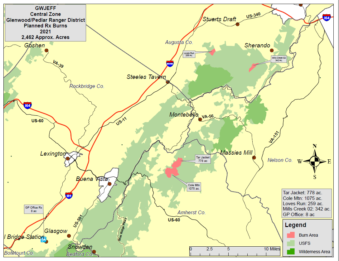
Prescribed Burns in the Loves Run and Mills Creek areas Augusta County
Related Incident:
Publication Type: News
The Forest Service plans to begin ignitions for the Love’s Run and Mills Creek burns on April 5, 2021, if weather conditions are appropriate. These prescribed burns will be completed over one to two days, with firefighters continuing to monitor the area for several days following the burns.
Prescribed burns help keep the public and homes safe by reducing the buildup of dried leaves and wood in nearby forest land that can lead to uncontrolled wildfires. These burns will also further objectives to restore yellow pines in these areas, increasing food and habitat for a diversity of wildlife species.
Locations:
Love’s Run Burn - The 259-acre Love’s Run burn unit is located 4.5 miles southwest of Stuarts Draft.
Mills Creek Burn - The 342-acre Mills Creek burn unit is located 5.5 miles southeast of Stuarts Draft.
Temporary Closures: For your safety, please follow posted signs and area closures when they occur.
Love’s Run Burn - Sections of Coal Road may be temporarily closed.
Mills Creek Burn - Turkey Pen Ridge Trail (#1237), Mills Creek Trail (#518) and sections of Coal Road may be temporarily closed.
Smoke: Depending on wind direction, residents within the vicinity of the burns as well as travelers along Interstates 81 and 64 may see or smell smoke.
Love’s Run Burn - The burn is expected to have lingering smoke effects in the Stuarts Draft area and along the Coal Road corridor.
Mills Creek Burn - The prescribed burn is expected to have lingering smoke effects in the Sherando area and along the Coal Road corridor.
Additional Information: For additional information visit Inciweb at https://inciweb.nwcg.gov/incident/article/7360/59091/.
To learn more about our prescribed burn program, please contact the Glenwood-Pedlar Ranger District Office at (540) 291-2188 or follow us on twitter: https://twitter.com/GWJNF1.
A map of prescribed burning units located on the Glenwood-Pedlar Ranger District is linked below.
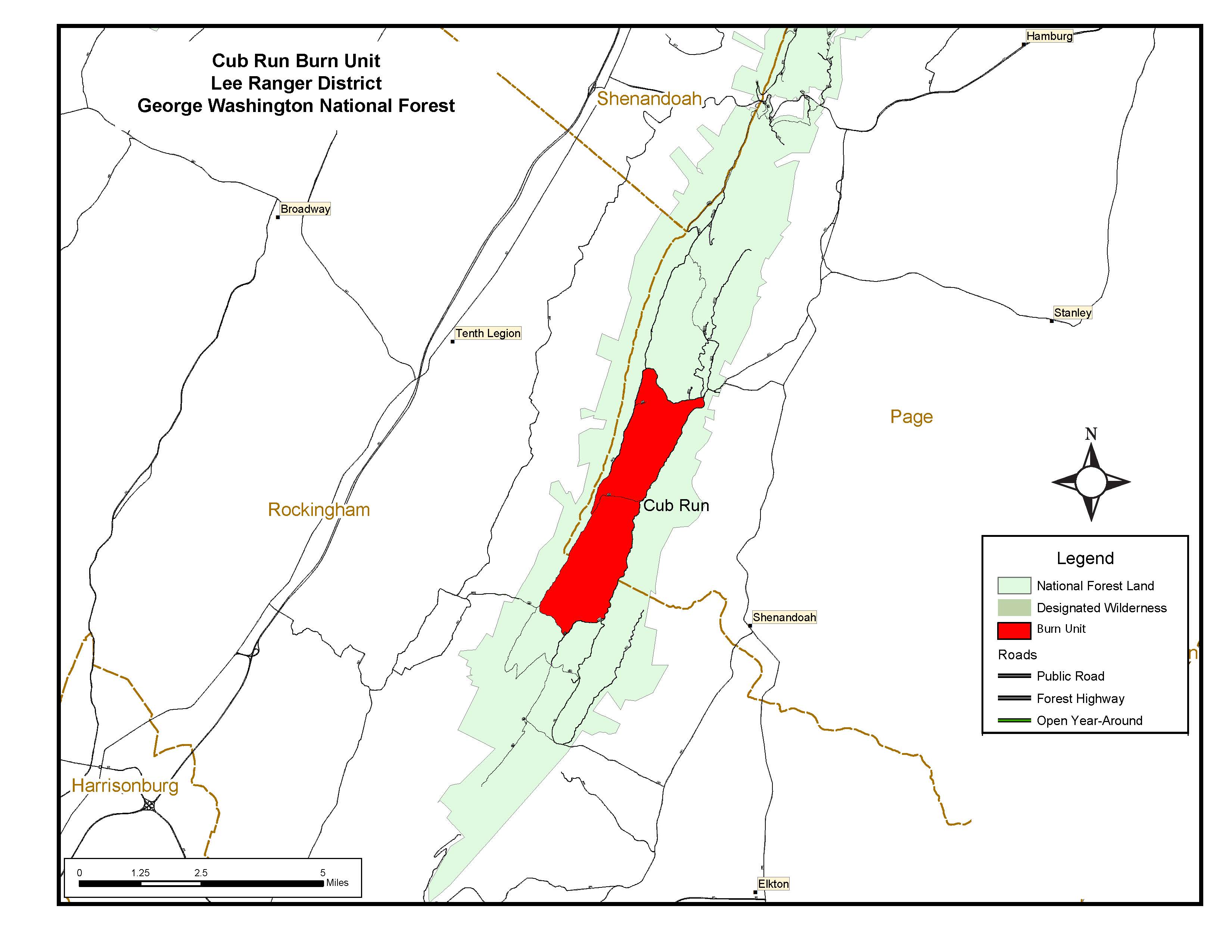
Prescribed Burn in the Cub Run area Page and Rockingham Counties
Related Incident:
Publication Type: News
Location: The 3,578-acre Cub Run burn area is located 2.3 miles west of the town of Shenandoah and 2.9 miles north of the Massanutten Resort.
Date and Time: The Forest Service plans to begin ignitions on Monday, April 5, 2021, if weather conditions are appropriate. This prescribed burn will be completed in two to three days. Firefighters will continue to monitor the area for several days after the burn.
Objective: Prescribed burns keep the public and homes safe by reducing the buildup of dried leaves and wood in nearby forest land that can lead to uncontrolled wildfires.
Additional Information: The Massanutten South Trail (Forest Trail 416), Fridley Gap Trail (Forest Trail 419), Second Mountain Trail (Forest Trail 580), Morgan Run Trail (Forest Trail 583), Martins Bottom Trail (Forest Trail 579) Cub Run Road (Forest Road 65) and Pitt Springs Road (Forest Road 375) may be temporarily closed. For your safety, please follow posted signs and comply with trail closures when they occur.
Depending on wind direction, this prescribed burn may have lingering smoke effects. Residents of Shenandoah, Massanutten, Elkton, New Market and Harrisonburg, and travelers on State Route 722, State Route 620, State Route 602 and U.S. Route 340 may see or smell smoke.
For more information on our prescribed burn program, please contact the Lee Ranger District Office at (540) 984-4101. You can also follow us on twitter: https://twitter.com/GWJNF1.
A map of the Cub Run burn unit located on the Lee Ranger District is linked below.
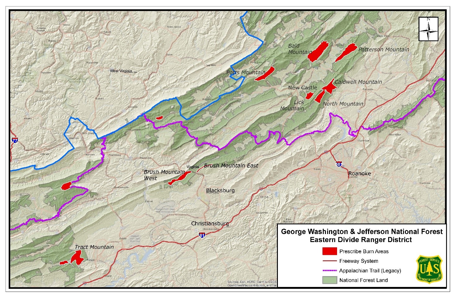
Prescribed Burn in the Patterson Mountain area Sub Unit 2 Botetourt County
Related Incident:
Publication Type: News
Location: This 685-acre burn will take place in the Patterson Mountain area located northeast of Marshalltown, Va. and north of Patterson Creek Road.
Date and Time: The Forest Service plans to begin ignitions on April 3, 2021, if weather conditions are appropriate. This prescribed burn will be completed over one to two days. Firefighters will continue to monitor the area for several days after the burn.
Objectives: Prescribed burns keep the public and homes safe by reducing the buildup of dried leaves and wood in nearby forest land that can lead to uncontrolled wildfires. They also create a mosaic of different aged trees and shrubs to improve wildlife habitat.
Additional Information: Depending on wind direction, residents and travelers around the town of Fincastle and along Interstate 81 may smell and see smoke.
For more information on our prescribed burn program, please contact the Eastern Divide Ranger District Office at (540) 552-4641 or follow us on twitter: https://twitter.com/GWJNF1.
A map of prescribed burning units located on the Eastern Divide Ranger District is linked below.