
REOPENED Temporary trail closures for Cobbler Mountain Prescribed Burn
Related Incident:
Publication Type: Closures
UPDATE - This trail has reopened following successful completion of the prescribed burn.
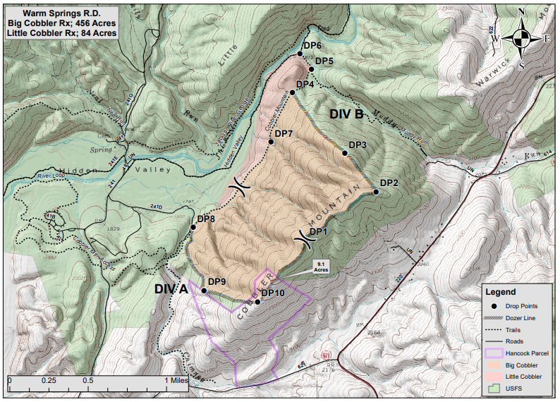
Cobbler Mountain Trail (#611) may be temporarily closed.
For your safety, please follow posted signs and closures when they occur.
See map of the Cobbler Mountain prescribed burn unit and vicinity linked below.
Prescribed Burn in Cobbler Mountain Gold Wing Warbler areas Bath County
Related Incident:
Publication Type: News
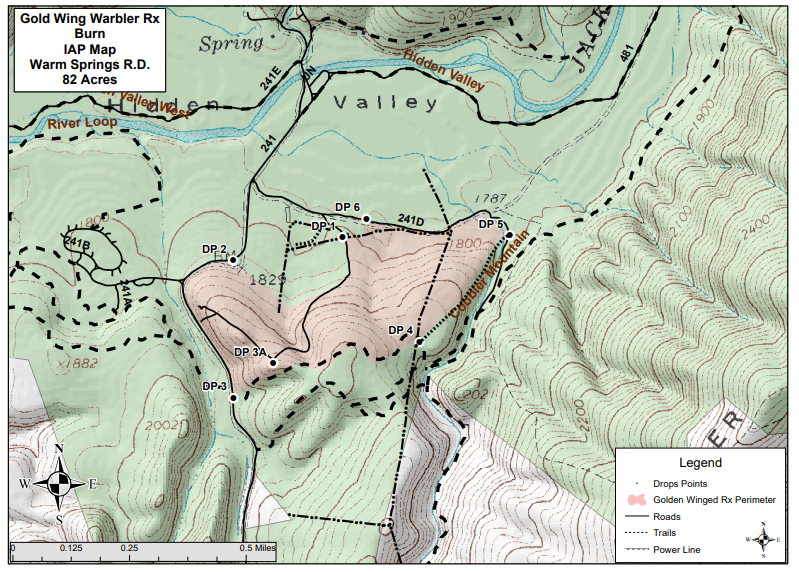
Location: The 540-acre Cobbler Mountain burn unit and the adjacent 82-acre Gold Wing Warbler burn are located on National Forest Service lands 4 miles northwest of Warm Springs, and north of Hidden Valley Road in Bath County. The Cobbler Mountain burn will be done in partnership with the Virginia Department of Forestry.
Date and Time: The Forest Service plans to begin ignitions on April 8, 2021, if weather conditions are appropriate. These prescribed burns will be completed in one day. Firefighters will continue to monitor the area for several days after the burn.
Objectives: Prescribed burns keep the public and homes safe by reducing the buildup of dried leaves and wood in nearby forest land that can lead to uncontrolled wildfires. They also create a mosaic of different aged trees and shrubs to improve wildlife habitat.
Temporary Closures: Cobbler Mountain Trail (#611) may be temporarily closed. For your safety, please follow posted signs and closures when they occur.
Smoke: The prescribed burn is expected to have lingering smoke effects in the Hot Springs, Warm Springs, Mountain Grove, and Minehaha Springs areas and along State Routes 39 and 220. Depending on wind direction, residents and travelers in these areas may see or smell smoke.
Additional Information: For additional information visit Inciweb at https://inciweb.nwcg.gov/incident/article/7360/59091/.
For more information on our prescribed burn program, please contact the Warm Springs Ranger District Office at 540-839-2521 or follow us on twitter: https://twitter.com/GWJNF1.
Maps of the Cobbler Mountain and Gold Wing Warbler prescribed burn units are linked below.
REOPENED Temporary trail road closures Moreland Gap Prescribed Burn
Related Incident:
Publication Type: Closures
UPDATE - These trails and roads have reopened following successful completion of the prescribed burn.
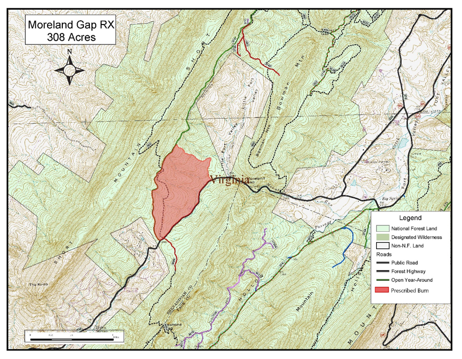
A section of the Massanutten Trail (Forest Trail #408) from Moreland Gap Road (Forest Road 374) to State Route 730, Moreland Gap Road (Forest Road 374) and State Route 730 may be temporarily closed. These areas will reopen when fire managers determine its safe again for public travel.
For your safety, please follow posted signs and comply with trail closures when they occur.
See map of the Moreland Gap prescribed burn unit and vicinity linked below.
Prescribed Burn in the Moreland Gap area Shenandoah County
Related Incident:
Publication Type: News
Location: The 308-acre Moreland Gap burn area is located on Short Mountain four miles east of Mount Jackson, Virginia.
Date and Time: The Forest Service plans to begin ignitions on Wednesday, April 7, 2021 if weather conditions are appropriate. This prescribed burn will be completed in one day. Firefighters will continue to monitor the area for several days after the burn.
Objective: Prescribed burns keep the public and homes safe by reducing the buildup of dried leaves and wood in nearby forest land that can lead to uncontrolled wildfires.
Temporary Closures: A section of the Massanutten Trail (Forest Trail #408) from Moreland Gap Road (Forest Road 374) to State Route 730, Moreland Gap Road (Forest Road 374) and State Route 730 may be temporarily closed. These areas will reopen when fire managers determine its safe again for public travel. For your safety, please follow posted signs and comply with trail closures when they occur.
Smoke: Depending on wind direction, this prescribed burn may have lingering smoke effects. Residents of Mount Jackson, New Market, Edinburg and Luray, and travelers on U.S. Route 11, Interstate 81 and State Route 730 may see or smell smoke.
Additional Information: For additional information visit Inciweb at https:// https://inciweb.nwcg.gov/incident/7360/.
For more information on our prescribed burn program, please contact the Lee Ranger District Office at (540) 984-4101. You can also follow us on twitter: https://twitter.com/GWJNF1.
A map of the Moreland Gap prescribed burn unit is linked below.
REOPENED Temporary trail road closures for New Road Run Prescribed Burn
Related Incident:
Publication Type: Closures
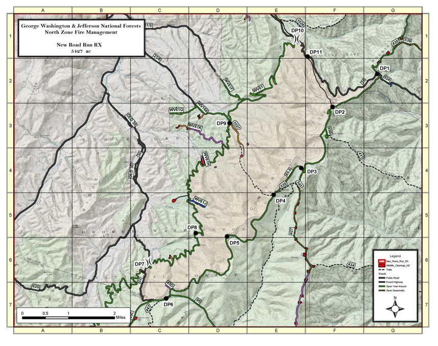
Reddish Knob Road (Forest Service Road 85-5), Little Stoney Road (Forest Service Road 61) and Little Stoney Trail (Forest Trail 1027) will be temporarily closed.
For your safety, please follow posted signs and comply with road closures when they occur.
See map of the New Road Run prescribed burn unit and vicinity linked below.
Prescribed Burn in the New Road Run area multiple Counties
Related Incident:
Publication Type: News
Location: The 5,427-acre New Road Run burn area is located on the western slope of Shenandoah Mountain on the West Virginia-Virginia state line, immediately west of the Little River Inventoried Roadless area and north of the Ramsey Draft Wilderness.
Date and Time: If weather conditions are appropriate, the Forest Service plans to begin ignitions on April 23. Ignitions should be completed in two to three days. Firefighters will monitor the area for several days following the burn.
Objective: Prescribed burns keep the public and homes safe by reducing the buildup of dried leaves and wood in nearby forest land that can lead to uncontrolled wildfires.
Temporary Closures: Reddish Knob Road (Forest Service Road 85-5), Little Stoney Road (Forest Service Road 61) and Little Stoney Trail (Forest Trail 1027) will be temporarily closed. For your safety, please follow posted signs and comply with road closures when they occur.
Smoke: Residents of Harrisonburg, Briery Branch, Ottobine, Clover Hills, Bridgewater, and Sugar Grove, Virginia, and Brandywine, West Virginia, and travelers on West Virginia County Route 25 and Virginia County Route 924, West Virginia Route 32, North River Road (Forest Service Road 95) and Stoney Run Road (Forest Service Road WV 61) may see or smell smoke. Depending on wind direction, this prescribed burn may have lingering smoke effects.
Additional Information: For additional information visit Inciweb at https:// https://inciweb.nwcg.gov/incident/7360/.
For more information on our prescribed burn program, please contact the North River Ranger District Office at (540) 432-0187. You can also follow us on twitter: https://twitter.com/GWJNF1.
A map of the New Road Run prescribed burn unit is linked below.
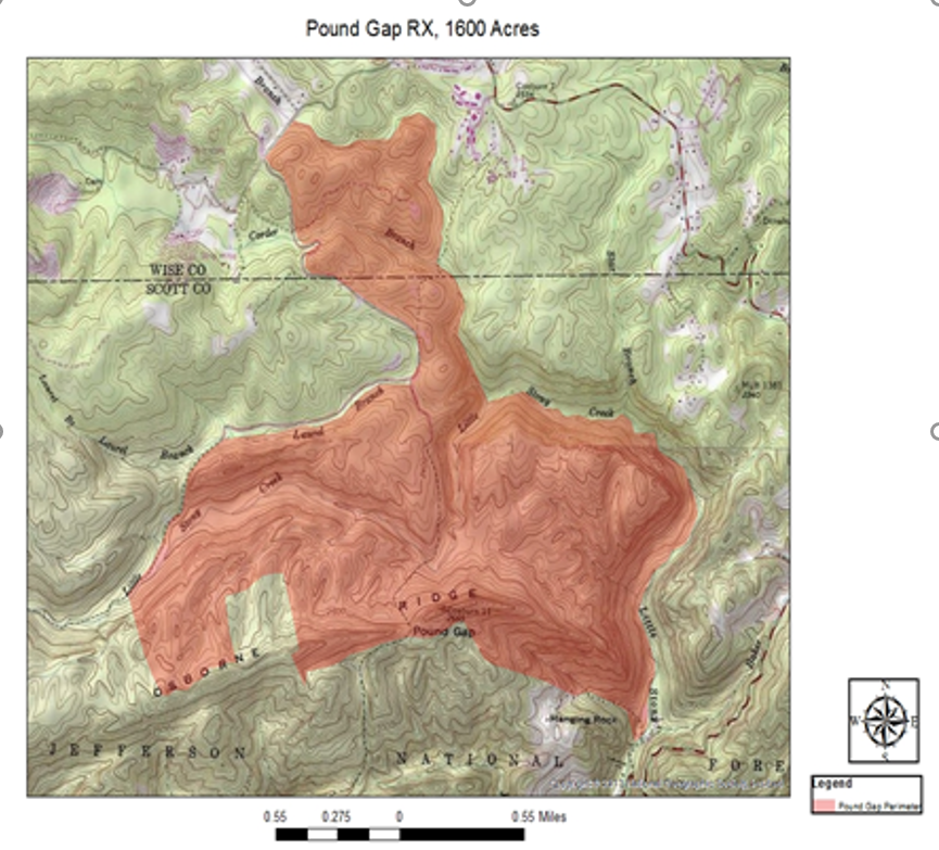
Prescribed burn in the Pound Gap area Wise and Scott Counties
Related Incident:
Publication Type: News
Location: The 1,603-acre Pound Gap prescribed burn unit is located approximately two miles from north Dungannon and adjacent to State Route 664 and Forest Road 700. Ramey Branch Creek and Little Stony Creek are also adjacent to this burn unit.
Date and Time: If weather conditions are appropriate, the Forest Service may begin ignitions on April 7, 2021. Ignitions should be completed in one day. Firefighters will monitor the area for several days after the burn.
Objective: Prescribed burns keep the public and homes safe by reducing the buildup of dried leaves and wood in nearby forest land that can lead to uncontrolled wildfires.
Smoke: Depending on wind direction, this prescribed burn may have lingering smoke effects. Residents of Coeburn and Dungannon and travelers on Highway 72 may see or smell smoke.
Additional Information: For additional information visit Inciweb at https://inciweb.nwcg.gov/incident/7360/.
For more information on our prescribed burn program, please contact the Clinch Ranger District at (276) 679-8370. You can also follow us on twitter: https://twitter.com/GWJNF1.
A map of the Pound Gap prescribed burn unit is linked below.
REOPENED Temporary trail and road closures for Tar Jacket Prescribed Burn
Related Incident:
Publication Type: Closures
UPDATE - These trails and roads have reopened following successful completion of the prescribed burn.
Approximately two miles of the Appalachian Trail along Tar Jacket Ridge between Hog Camp Gap (mile 815.4) and Salt Log Gap (mile 817.6) will be temporarily closed. The trail closure would last for one day and would re-open the following day. Hiker shuttling services are not provided. There is no alternate route for this section. Hog Camp Road may also be temporarily closed during the prescribed burn.
For your safety, please follow posted signs and trail closures when they occur.
See map of the Tar Jacket prescribed burn unit and vicinity linked below.
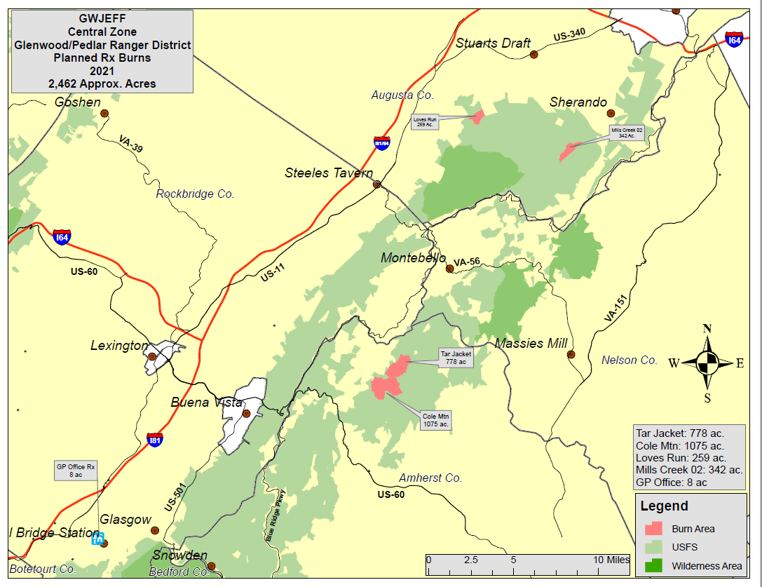
Prescribed Burn in the Tar Jacket area Amherst County
Related Incident:
Publication Type: News
Location: The 778-acre Tar Jacket burn unit is located eight miles northeast of Buena Vista and six miles northeast of Forks of Buffalo.
Date and Time: The Forest Service plans to begin ignitions on April 7, 2021, if weather conditions are appropriate. This prescribed burn will be completed in one day. Firefighters will continue to monitor the area for several days after the burn.
Objective: Prescribed burns keep the public and homes safe by reducing the buildup of dried leaves and wood in nearby forest land that can lead to uncontrolled wildfires. This prescribed burn will also reduce vegetation to improve wildlife habitat and maintain existing fields along the Appalachian Trail that provide scenic views.
Temporary Closures: Approximately two miles of the Appalachian Trail along Tar Jacket Ridge between Hog Camp Gap (mile 815.4) and Salt Log Gap (mile 817.6) will be temporarily closed. The trail closure would last for one day and would re-open the following day. Hiker shuttling services are not provided. There is no alternate route for this section. Hog Camp Road may also be temporarily closed during the prescribed burn. For your safety, please follow posted signs and trail closures when they occur.
Smoke: The prescribed burn is expected to have lingering smoke effects in the Mount Pleasant National Scenic Area and along the Hog Camp and Big Piney Road corridors. Depending on wind direction, residents and travelers in these areas may see or smell smoke.
Additional Information: For additional information visit Inciweb at https:// https://inciweb.nwcg.gov/incident/7360/.
For more information on our prescribed burn program, please contact the Glenwood-Pedlar Ranger District at (540) 291-2188 or visit our website www.fs.fed.us/r8/gwj. You can also follow us on twitter: https://twitter.com/GWJNF1.
A map of the Tar Jacket prescribed burn unit is located below.
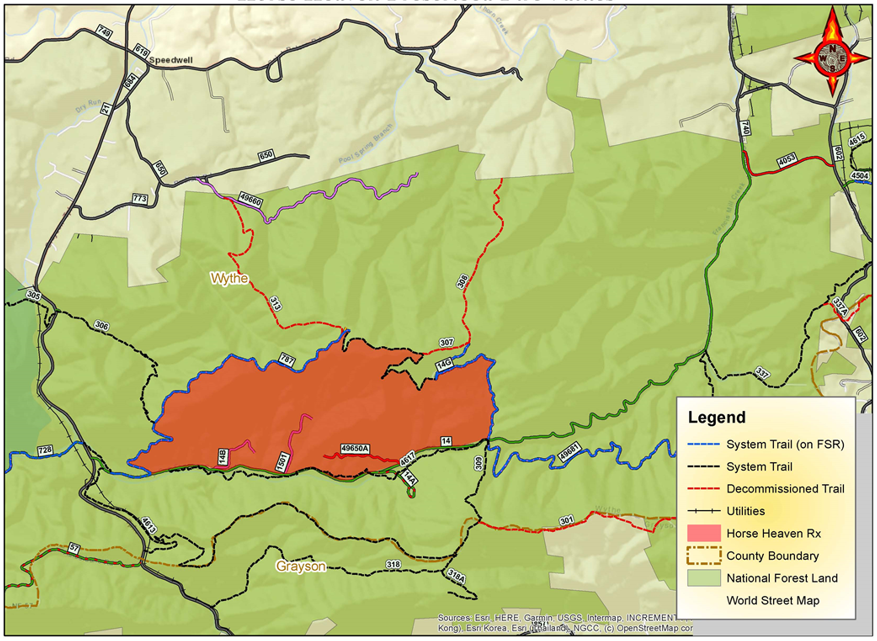
REOPENED Temporary trail road closures for Horse Heaven Prescribed Burn
Related Incident:
Publication Type: Closures
UPDATE - These trails and roads have reopened following successful completion of the prescribed burn.
The Virginia Highlands Horse Trail (Trail # 337) lies within the prescribed fire area and will be temporarily closed during the burn for Public Safety. Forest Service Trail #4617 will remain open but may be impacted by smoke. The following Forest Service Roads (FSR) will also be closed for the duration of the burn: FSR 14B, FSR 14G, FSR 1501, and Forest Heaven Road (FSR 787). These roads will reopen when fire managers determine its safe again for public travel. CC Camp Road (FSR 14) will temporarily be closed during active ignitions along the roadside. As soon as its safe FSR 14 will be reopened for public travel. Public using Forest Service roads are cautioned to slow down, drive defensively, and be prepared to encounter firefighters and equipment along with smoke along the roadway.
For your safety and the safety of firefighters please follow posted signs and comply with trail closures when they occur.
See map of the Horse Heaven prescribed burn unit and vicinity linked below.