
REOPENED Temporary road trail closures Brushy Ridge Prescribed Burn
Related Incident:
Publication Type: Closures
Brushy Ridge Trail (FS Trail #456), as well as County Road 629, Dolly Anne Road and Limekiln Road may be temporarily closed.
For your safety, please follow posted signs and closures when they occur.
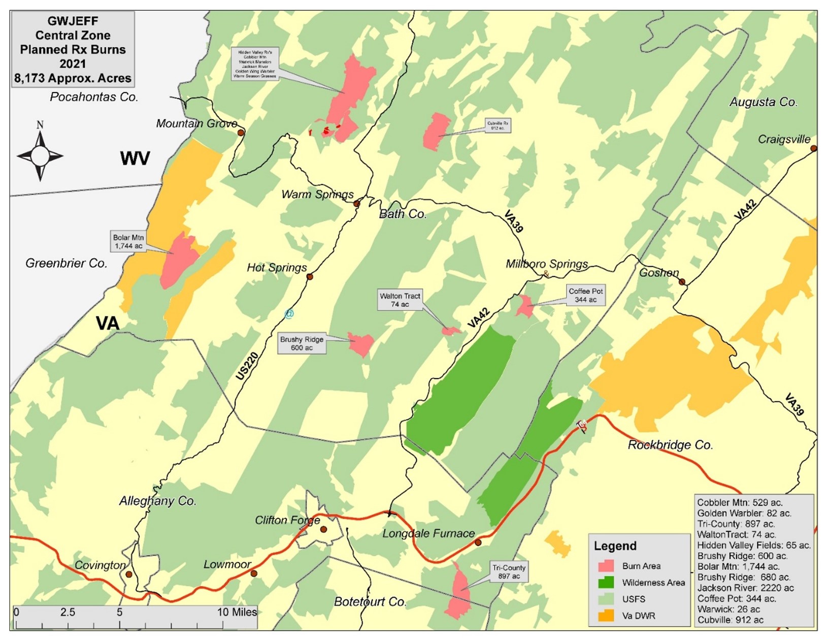
Prescribed burn in the Brushy Ridge area Bath County
Related Incident:
Publication Type: News
Location: The 600-acre Brushy Ridge burn unit is located on National Forest Service lands approximately 8 miles north of Clifton Forge and 2 miles north of Douthat State Park in Bath County.
Date and Time: The Forest Service plans to begin ignitions on April 20, 2021, if weather conditions are appropriate. The prescribed burn will be completed in one to two days. Firefighters will continue to monitor the area for several days after the burn.
Objectives: Prescribed burns keep the public and homes safe by reducing the buildup of dried leaves and wood in nearby forest land that can lead to uncontrolled wildfires. They also create a mosaic of different aged trees and shrubs to improve wildlife habitat, and promote the regeneration of native, fire-tolerant tree species like oaks.
Temporary Closures: Brushy Ridge Trail (FS Trail #456), as well as County Road 629, Dolly Anne Road and Limekiln Road may be temporarily closed. For your safety, please follow posted signs and closures when they occur.
Smoke: The prescribed burn is expected to have lingering smoke effects along County Road 629. Depending on wind direction, residents and travelers in this area may see or smell smoke.
Additional Information: For additional information visit Inciweb at https://inciweb.nwcg.gov/incident/article/7360/59091/.
For more information on our prescribed burn program, please contact the Warm Springs Ranger District Office at 540-839-2521 or follow us on twitter: https://twitter.com/GWJNF1.
A map of prescribed burning units located on the Warm Springs Ranger District is linked below.
PLANNED Temporary road closure Coffee Pot Prescribed Burn
Related Incident:
Publication Type: Closures
Coffee Pot Road may be temporarily closed.
For your safety, please follow posted signs and closures when they occur.
Prescribed burn in the Coffee Pot area Bath County
Related Incident:
Publication Type: News
Location: The 344-acre Coffee Pot burn unit is located on National Forest Service lands approximately 1.5 miles southwest of Millboro Springs and 7 miles west of Goshen in Bath County.
Date and Time: The Forest Service plans to begin ignitions in late April, if weather conditions are appropriate. The prescribed burn will be completed in one to two days. Firefighters will continue to monitor the area for several days after the burn.
Objectives: Prescribed burns keep the public and homes safe by reducing the buildup of dried leaves and wood in nearby forest land that can lead to uncontrolled wildfires. They also create a mosaic of different aged trees and shrubs to improve wildlife habitat, and promote the regeneration of native, fire-tolerant tree species like oaks.
Temporary Closures: Coffee Pot Road may be temporarily closed. For your safety, please follow posted signs and closures when they occur.
Smoke: The prescribed burn is expected to have lingering smoke effects in the Millboro Springs area, as well as along State Routes 42 and 39. Depending on wind direction, residents and travelers in these areas may see or smell smoke.
Additional Information: For additional information visit Inciweb at https://inciweb.nwcg.gov/incident/article/7360/59091/.
For more information on our prescribed burn program, please contact the Warm Springs Ranger District Office at 540-839-2521 or follow us on twitter: https://twitter.com/GWJNF1.
A map of prescribed burning units located on the Warm Springs Ranger District is linked below.
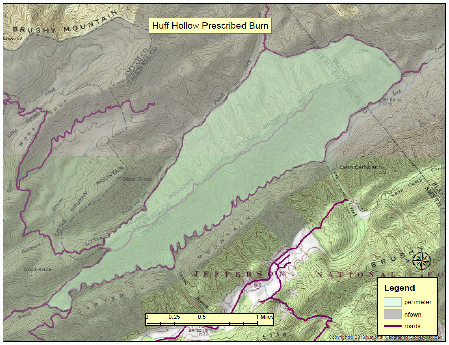
REOPENED Temporary road closures Huff Hollow Prescribed Burn
Related Incident:
Publication Type: Closures
Forest Service Roads 614 (Baker Branch), 618 (Punch and Judy) and 878 (Totten Branch) will be temporarily closed while the prescribed burn is active.
For your safety, please follow posted signs and closures when they occur.
Prescribed burn in the Huff Hollow area multiple counties
Related Incident:
Publication Type: News
Location: The 1,498-acre Huff Hollow prescribed burn unit is located on National Forest Service lands along Little Brushy Mountain, approximately 1.5 miles northeast of Chatham Hill and 1.5 miles east of State Highway 16 in Tazewell, Smyth and Bland Counties. The unit is bordered by Forest Service Roads 614, 618 and 878.
Date and Time: The Forest Service plans to begin ignitions on April 20, 2021, if weather conditions are appropriate. The prescribed burn will be completed in one to two days. Firefighters will continue to monitor the area for several days after the burn.
Objectives: Prescribed burns keep the public and homes safe by reducing the buildup of dried leaves and wood in nearby forest land that can lead to uncontrolled wildfires. Temporary Closures: Forest Service Roads 614 (Baker Branch), 618 (Punch and Judy) and 878 (Totten Branch) will be temporarily closed while the prescribed burn is active. For your safety, please follow posted signs and closures when they occur.
Smoke: Depending on wind direction, this prescribed burn may have lingering smoke effects. Residents of Marion, Wytheville and Bland, as well as travelers on State Highway 16 may see or smell smoke. Hikers on a nearby section of the Appalachian Trail may also see or smell smoke.
Additional Information: For additional information visit Inciweb at https://inciweb.nwcg.gov/incident/article/7360/59091/.
For more information on our prescribed burn program, please contact the Mount Rogers National Recreation Area Office at 276-783-5196 or follow us on twitter: https://twitter.com/GWJNF1.
A map of the Huff Hollow prescribed burn unit is linked below.
REOPENED Temporary trail road closures Cubville Prescribed Burn
Related Incident:
Publication Type: Closures
Jordan Run and Piney Mountain Roads, and Piney Mountain Trail (FS Trail #453) may be temporarily closed.
For your safety, please follow posted signs and closures when they occur.
Prescribed Burn in the Cubville area Bath County
Related Incident:
Publication Type: News
Location: The 912-acre Cubville burn unit is located on National Forest Service lands approximately 5 miles northeast of Warm Springs and 13 miles northwest of Goshen in Bath County.
Date and Time: The Forest Service plans to begin ignitions on April 17, 2021, if weather conditions are appropriate. The prescribed burn will be completed over several days, starting with ignitions along the perimeter of the unit. Firefighters will continue to monitor the area for several days after the burn.
Objectives: Prescribed burns keep the public and homes safe by reducing the buildup of dried leaves and wood in nearby forest land that can lead to uncontrolled wildfires. They also create a mosaic of different aged trees and shrubs to improve wildlife habitat, and promote the regeneration of native, fire-tolerant tree species like oaks.
Temporary Closures: Jordan Run and Piney Mountain Roads, and Piney Mountain Trail (FS Trail #453) may be temporarily closed. For your safety, please follow posted signs and closures when they occur.
Smoke: The prescribed burn is expected to have lingering smoke effects in the Millboro, Burnsville and Williamsville areas, as well as along County Route 609 and Virginia Highway 39. Depending on wind direction, residents and travelers in these areas may see or smell smoke.
Additional Information: For additional information visit Inciweb at https://inciweb.nwcg.gov/incident/article/7360/59091/.
For more information on our prescribed burn program, please contact the Warm Springs Ranger District Office at 540-839-2521 or follow us on twitter: https://twitter.com/GWJNF1.
A map of prescribed burning units located on the Warm Springs Ranger District is linked below.
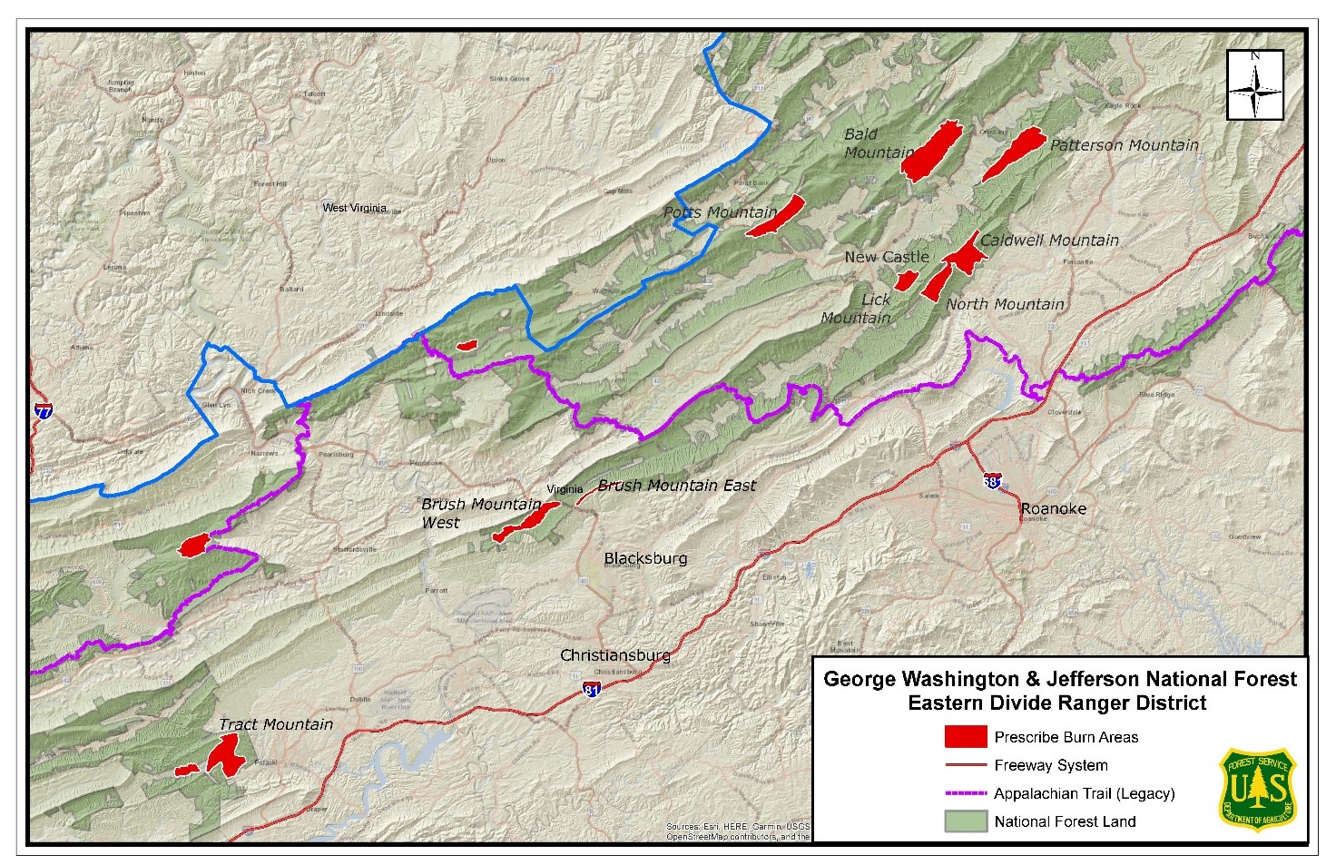
Prescribed burn in the Patterson Mountain area Sub Unit 1Botetourt County
Related Incident:
Publication Type: News
Location: This 1,565-acre burn will take place in the Patterson Mountain area located northeast of Marshalltown, Va. and north of Patterson Creek Road.
Date and Time: The Forest Service plans to begin ignitions on April 13, 2021, if weather conditions are appropriate. This prescribed burn will be completed over one to two days. Firefighters will continue to monitor the area for several days after the burn.
Objectives: Prescribed burns keep the public and homes safe by reducing the buildup of dried leaves and wood in nearby forest land that can lead to uncontrolled wildfires. They also create a mosaic of different aged trees and shrubs to improve wildlife habitat.
Smoke: Depending on wind direction, residents and travelers around the town of Fincastle and along Interstate 81 may smell and see smoke.
Additional Information: For additional information visit Inciweb at https:// https://inciweb.nwcg.gov/incident/7360/.
For more information on our prescribed burn program, please contact the Eastern Divide Ranger District Office at (540) 552-4641 or follow us on twitter: https://twitter.com/GWJNF1.
A map of prescribed burning units located on the Eastern Divide Ranger District is linked below.